
Dispatches from the Front Lines of Climate Change
By definition, global climate change is reflected in a host of changes all over the planet. But changes do not occur uniformly across the globe. Changes in the Arctic have been generally more rapid than those anywhere else on Earth. Strange sights — such as forests of “drunken trees” loosened by thawing permafrost — provide dramatic visual evidence of this rapid change (Figure 1).
Why is Earth Warming?
Greenhouse gases such as carbon dioxide and methane absorb heat emitted from Earth’s surface. Increases in the atmospheric concentrations of these gases cause Earth to warm by trapping more of this heat. Human activities — especially the burning of fossil fuels — have increased atmospheric carbon dioxide concentrations by about 40 percent, with more than half the increase occurring since 1970. Since 1900, the global average surface temperature has increased by about 0.8°C (1.4°F).
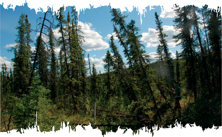
FIGURE 1. This forest of “drunken trees” in Alaska is a clear sign of thawing permafrost. When permafrost thaws it can make the ground buckle, causing trees to lose their footing and tip over at odd angles. Source: National Snow and Ice Data Center, University of Colorado, Boulder/Tingjun Zhang
Arctic Ocean Acidification
As well as warming the atmosphere, excess carbon dioxide is also absorbed by the ocean, forming carbonic acid that makes seawater more acidic (lower pH), a phenomenon called ocean acidification. Ocean acidification threatens the health of marine organisms, such as corals and some shellfish, which have shells composed of calcium carbonate — a material that dissolves at lower pH. As the pH of sea water decreases, it will become more difficult for these organisms to form or maintain their shells, with impacts that ripple throughout the marine ecosystem.
The Arctic Ocean is particularly sensitive to ocean acidification: frigid Arctic waters absorb more carbon dioxide than temperate waters. Additionally, declines in the extent of summer sea ice will expose more ocean area, allowing for greater transfer of carbon dioxide from the atmosphere into the ocean.
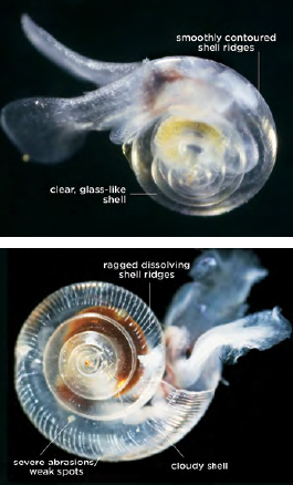
Tiny sea snails called pteropods are one example of an Arctic marine species at risk from ocean acidification. Pteropods swim near the ocean surface and provide food for a variety of fish. Healthy pteropods have smooth, transparent shells (top). In lower pH conditions, pteropod shells can start to dissolve and appear cloudy, ragged, and pockmarked (bottom). Source: NOAA
Temperatures are rising twice as fast in the Arctic as compared to the average global temperature rise (Figure 2). The most dramatic manifestation of this warming is seen during the Arctic winters, which are becoming milder. The temperature of the Arctic Ocean is also increasing, a pattern that is exacerbated as sea ice melts, leaving more of the water’s surface exposed and allowing more heat to be taken up by the open water during the summer months.
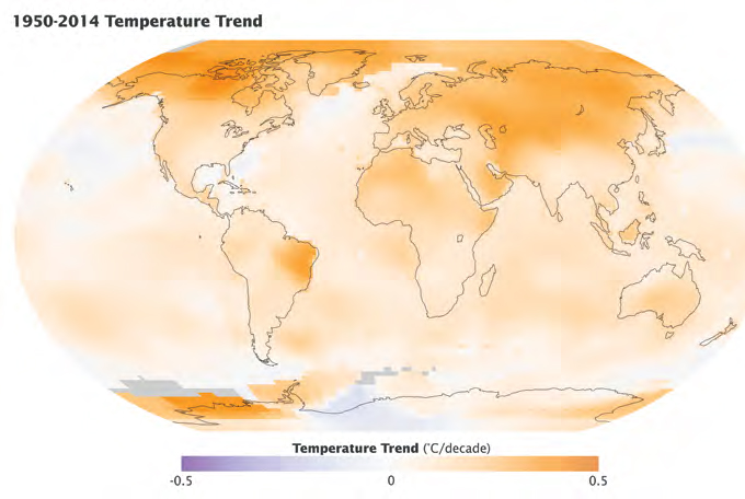
FIGURE 2. Temperatures have risen faster in the Arctic than elsewhere on the globe. This map depicts the temperature trend from 1950 to 2014. This analysis was assembled using publicly available data from roughly 6,300 meteorological stations around the world; ship-based and satellite observations of sea surface temperature; and Antarctic research station measurements. Source: NASA Earth Observatory/ NASA Goddard Institute for Space Studies (GISS)/ Kevin Ward
If you were to stand at the North Pole, the snow and ice under your boots would feel rock-solid, and its white expanse might extend as far as you could see. But you would not be standing on land, because Earth’s North Pole is in the middle of the Arctic Ocean. You would be standing on sea ice — ice floating on the ocean’s surface.
Each summer, as temperatures rise above freezing, the ice begins to melt and the area covered by sea ice shrinks (Figure 3). In winter, sea ice coverage expands again as sea water freezes.
But over the past several decades, warmer temperatures have meant there is less sea ice left at the end of the summer. Using satellites, scientists have found that the area of sea ice coverage each September has declined by more than 40 percent since the late 1970s, a trend that has accelerated since 2007.
In fact, by the end of each of the eight summers from 2007–2014, Arctic sea ice extended over less area than at any time in the preceding three decades — the time period for which we have satellite observations. In 2012, the ice shrank to its smallest extent ever recorded by satellites, with the ice covering only half the area covered just 30 years earlier.
This striking decrease in summer ice has also caused winter ice to become thinner and less stable. Even a few decades ago, a large core of sea ice survived the summer and beyond, thickening and hardening over many winters to become multiyear ice (generally 3–4 meters [10–13 feet] thick). But now, more summer melting means an increasing fraction of winter sea ice cover is first-year sea ice (generally only 1–2 meters [3–7 feet] thick) that melts more quickly and breaks up more easily in the summer, contributing to the overall trend of sea ice loss (Figure 4).
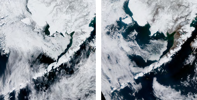
FIGURE 3. These images of Alaska’s Bristol Bay, taken by the Moderate Resolution Imaging Spectroradiometer (MODIS) on the NASA Aqua satellite, illustrate the thinning and thawing of arctic sea ice each spring. The image on the left was taken on April 11 2012, and shows sea ice hugging the shore. Two weeks later, on April 24, the ice had retreated (right). Source: NASA Earth Observatory/ Jesse Allen
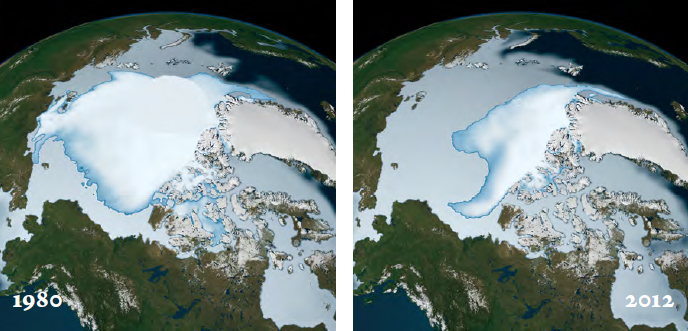
FIGURE 4. The extent of multi-year ice is decreasing rapidly. These visualizations show sea ice coverage in 1980 (left) and 2012 (right). Multi-year ice is shown in bright white, while younger sea ice is shown in light blue to milky white. The data show the ice cover for the period of November 1 through January 31 in their respective years. Source: NASA Earth Observatory
The Science of Predicting Sea Ice
Accurate sea ice predictions are crucial to modeling atmospheric and oceanographic processes, understanding ecological changes, and helping people know what to expect when venturing into the area to extract resources or transport goods. Scientists use satellites, ships, and airplanes to measure the areal extent of ice covering the Arctic Ocean, the thickness of the ice, and other characteristics. These measurements are then integrated with computer models to project what could happen in the future.
Despite sophisticated measurements and computer models, our prediction capability is limited. For example, seasonal forecasts from 21 research groups all underestimated the record-setting summer sea ice loss of 2012. The 2012 National Research Council report Seasonal-to-Decadal Predictions of Arctic Sea Ice: Challenges and Strategies offers strategies to improve sea ice projections.
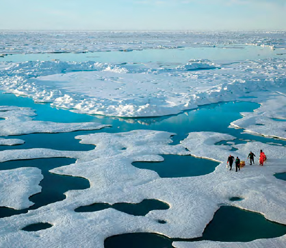
The blanket of ice coating Earth’s northernmost seas is thin and ragged by summer. This photo shows scientists treading carefully over ice in the Canada Basin of the Arctic in July 2005.
Source: NOAA/OAR/OER/Jeremy Potter
Ice is melting at a rapid pace on the land masses that encircle the Arctic Ocean.
Glaciers, many of which have endured since the last Ice Age or longer, are becoming smaller (Figure 5). Those that border bodies of water are increasingly breaking off into icebergs, a process called calving. The icebergs then float away and gradually melt into the sea.
The Greenland ice sheet is essentially an enormous glacier that extends about 1,699,000 square kilometers (656,000 square miles) and covers most of the island of Greenland. In recent decades, this ice sheet has begun to decrease in size and mass as a result of warmer summer temperatures melting ice at the surface, and increased calving of ice at the island’s edges.
Snow cover has also decreased as temperatures rise and snow melts off more quickly in the spring and summer. For example, snow cover in June 2012 was 40 percent below the average from 1971–2000 — the baseline period of observations — in many areas of the Arctic.
This loss of ice from Arctic land masses contributes to sea level rise, alters the way water moves over and through the land, and could affect the circulation of the oceans and atmosphere globally.
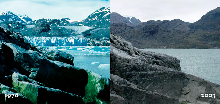
FIGURE 5. Recent losses of land ice are illustrated by comparing a 1976 photograph of Muir Glacier in Glacier Bay National Park and Preserve, Alaska (left) with a 2003 photograph of the same glacier (right). The 1976 photograph shows the calving edge of Muir Glacier (where icebergs break off) extending the width of the fiord, and aside from algae growing on a lighter colored dike, there is no vegetation visible in the photograph. The 2003 photograph documents the disappearance of Muir Glacier from the field of view, and shows vegetation beginning to develop. Source: USGS/Bruce F. Molnia.
Snow largely a no-show for 2014 Iditarod Trail Sled Dog Race
On March 1, 2014, 65 mushers and their teams of dogs left Anchorage, Alaska, on a quest to win the Iditarod — a race covering 1,000 miles of mountain ranges, frozen rivers, dense forest, tundra and coastline. According to local news reports, a lack of snow covering the trail’s harsh terrain made the race especially challenging, and many mushers pulled out of the race due to injuries and broken sleds. This map shows model-estimated snow depth across Alaska as of March 5, 2014. Historical Iditarod trail routes are shown in black. Snow depth increases from gray (one foot or less), to blue, to white (3 feet or more).
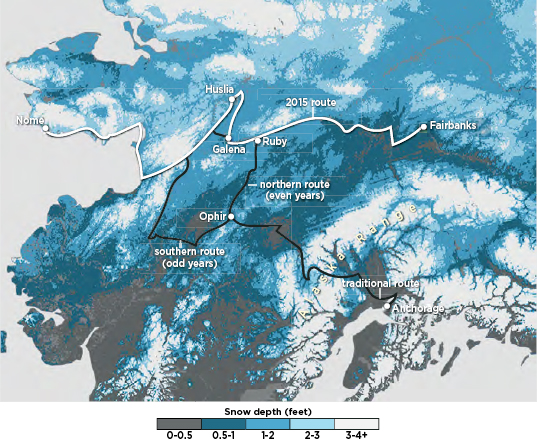
Source: NOAA Climate.gov/ NWS NOHRSC
Although permafrost derives its name from the word “permanent,” it is becoming markedly less so.
Defined as soil, rock, and any other subsurface earth material that exists at or below freezing for two or more consecutive years, permafrost thaws when ground temperatures increase. Permafrost ranges from solid to sporadic, depending on temperature and soil type. Discontinuous (patchy) permafrost is particularly susceptible to thawing. Scientists have seen declines in permafrost over the past 30 years and predict that discontinuous permafrost will likely disappear across much of the Arctic, where ground temperatures are now within 1–2° C (1.8–3.6° F) of thawing.
The effects of changes in permafrost are complex because each area has a unique geological, chemical, atmospheric, and biological environment. When permafrost thaws, it can have significant impacts on an area’s landscape, ecosystem, hydrology, and infrastructure, for example by causing the collapse of roads, bridges, runways and buildings (Figure 6).
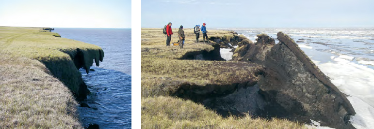
FIGURE 6. Ocean waves erode coastlines the world over, but in parts of Alaska coastal erosion has accelerated due to two climate-driven phenomena: declining sea ice and thawing permafrost. Arctic sea ice absorbs wave energy, dampening the waves that beat against the shoreline, but declines in summertime sea ice cover are creating expanses of open ocean that allow storms to stir up waves. At the same time, thawing permafrost means that land is becoming softer and more vulnerable to erosion. Taken near Drew Point, along Alaska’s northern coast, the photo on the left shows how ocean waves have undercut the land nearest the shore. The photo on the right, taken about a year later, shows chunks of coastline tumbling into the sea. Source: Stratus Consulting/University of Colorado; NOAA Climate.gov
How Do You Measure Permafrost?
To directly measure permafrost, scientists drill into the ground, measure the temperature, and analyze samples to see how long the ground has been frozen. But this approach can only be deployed in a tiny fraction of places where permafrost exists. To determine the extent of permafrost across the entire Arctic — and track its disappearance — scientists use a variety of measurements.
For example, sophisticated sensors on ground-based equipment, aircraft, and satellites provide information about ice and snow on the ground, topography and shifts in the landscape over time, soil characteristics and chemistry, vegetation, and many other factors. These factors can be used to monitor permafrost indirectly.
A 2014 National Research Council workshop summarized in the report Opportunities to Use Remote Sensing in Understanding Permafrost and Related Ecological Characteristics explored how remote sensing technologies could be harnessed to advance knowledge about permafrost.
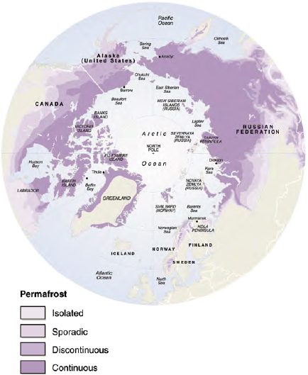
The distribution of permafrost in the Arctic.
Source: Philippe Rekacewicz, UNEP/GRID-Arendal
ARCTIC ECOSYSTEMS ARE CHANGING.
The Arctic is home to living creatures found nowhere else on Earth. Many are highly specialized, having evolved in response to the unique Arctic environment over millions of years. As ice melts and temperatures change, these species face mounting challenges — including the possibility of extinction.
Some of the most recognizable Arctic animals, such as polar bears, seals, and walruses, rely on sea ice as a platform for resting and hunting. Like the Arctic’s human residents, these animals face the loss of habitat and drastically reduced hunting ranges as sea ice recedes.
For example, in past years walruses in the Chukchi Sea (between Alaska and the Russian Far East) would have been found scattered across a large area of sea ice overhanging the shallow waters of the continental shelf, using the ice as a resting platform between dives to forage for clams and worms in the seabed. In recent years, however, that sea ice has largely been confined to the deeper waters of the far north, forcing tens of thousands of walruses to come ashore in Alaska and Russia (Figure 7). From land, the walruses must travel farther to reach their prey, forcing them to expend extra energy and making them more vulnerable to illness, competition, and trampling.
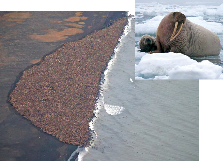
FIGURE 7. In September 2014, an estimated 35,000 walrus came ashore in Point Lay, Alaska. Source: NOAA
INSET: A female walrus and pup rest on an ice floe. Source: U.S. Geological Survey/Sarah Sonsthagen
As the Arctic grows more temperate, some species are seizing the opportunity to expand into new territory. The melting of sea ice has created new expanses of open ocean, allowing large populations of phytoplankton to bloom and causing shifts in the marine food chain. On land, shrubs are expanding in the tundra and invasive insects are sweeping across the forests (Figure 8). As Arctic summers warm and the ice-free season lengthens, more species from the south could begin to spread northward. Competition from these species for food and other resources could potentially lead to major ecosystem reorganization and even extinctions.
Arctic ecologists are particularly concerned about “tipping points” — thresholds where a small change in climate could have major, irreversible ecological impacts. Scientists are investigating how to predict tipping points in the hope of developing strategies to minimize their impacts. The 2011 National Research Council report Frontiers in Understanding Climate Change and Polar Ecosystems identifies key research questions to better understand the ecological impacts of climate change in the Arctic.
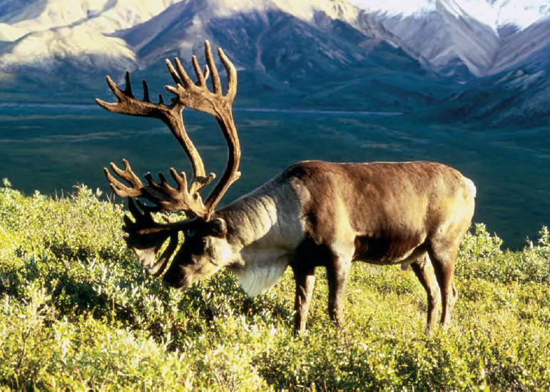
As climate warms, shrubs have started to grow in areas previously dominated by tundra vegetation such as lichens, an important winter food source for caribou. The loss of lichens can lead to declines in the growth and abundance of caribou, which in turn, are an important food source for hunters from the Arctic’s indigenous communities as well as for predators such as bears and wolves. Source: U.S. Fish and Wildlife Service/Dean Biggins
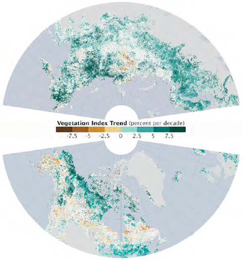
FIGURE 8. As temperatures have risen in the Arctic, the growing season has got longer in the far northern latitudes, bringing major changes to Arctic ecosystems. Instruments on NASA and NOAA satellites have continuously monitored the growth of vegetation from space since the late 1970s. Scientists use that information to calculate the Normalized Difference Vegetation Index (NDVI), an indicator of photosynthetic activity, or the “greenness” of the landscape. These maps show NDVI trends between July 1982 and December 2011 for the northern portions of North America and Eurasia. Shades of green depict areas where plant productivity and abundance increased; shades of brown show where photosynthetic activity declined. There was no significant trend in areas that are white, and areas that are gray were not included in the study. The maps show a ring of greening in the treeless tundra ecosystems of the circumpolar Arctic — the northernmost parts of Canada, Russia, and Scandinavia. Tall shrubs and trees started to grow in areas that were previously dominated by tundra grasses. The researchers concluded that plant growth had increased by 7 to 10 percent overall. Source: NASA Earth Observatory
As Permafrost Thaws, Ancient Treasures are Exposed
As temperatures warm, artifacts and biological specimens that have been frozen in place for thousands of years have begun to emerge from thawing permafrost and eroding coastlines, bearing profound messages about human history and the evolution of life on Earth.
Scientists are racing to take advantage of these great opportunities to understand the region’s rich human history through archaeological discovery — but as these artifacts are exposed to the air, many culturally and historically significant sites will start to decompose and will be lost forever.
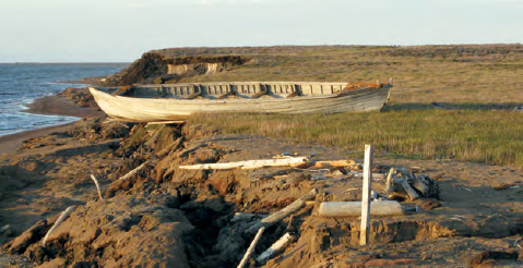
A nearly century-old whaling boat along the Beaufort Sea coast near Lonely, Alaska. The boat washed away to sea just a few months later due to erosion, an example of how rapid change can lead to the loss of historical sites.
Source: USGS/ Benjamin Jones
LIFE IS CHANGING FOR THE PEOPLE OF THE ARCTIC.
The Arctic is home to about 4 million people. They range from city dwellers to oil prospectors to hunters and herders living on the land. Many are members of indigenous groups whose ancestors have lived in the Arctic for millennia. They are citizens of eight different countries who speak dozens of distinct languages.
These unique and diverse Arctic communities face an uncertain future. Thawing permafrost poses particularly significant problems. As permafrost thaws, the shape of the land changes and streams or bodies of water can form in areas that were previously dry. Resulting erosion wreaks havoc on buildings, roads, pipes, and other infrastructure, costing communities hundreds of millions of dollars as they struggle to make repairs and keep up with changing conditions.
Towns situated along the coasts are especially vulnerable. Historically, large swaths of sea ice forming along the shoreline have provided a buffer against coastal storms and waves. As sea ice declines, coastal communities face the full brunt of increasingly strong storms. In addition, sea-level rise threatens low-lying communities, and advancing seas and stronger storms may force some communities to relocate.
The 2014 National Research Council report The Arctic in the Anthropocene: Emerging Research Questions explores the need for actionable Arctic science to better understand how environmental and societal changes will affect the Arctic and the rest of the world.
Threats to an Ancient Way of Life
The Arctic’s indigenous communities exist at the intersection of the modern world and a cultural history thousands of years old. Changes in the Arctic environment — combined with broad political, economic, and cultural shifts — are putting new strains on ancient traditions.
Many Arctic indigenous groups have traditionally moved between seasonal camps and settlements to optimize opportunities for hunting, fishing, herding, and farming. This way of life has faded with the advent of property ownership, government regulations, and housing developments. In addition, melting snow and ice poses problems for subsistence hunters, who typically rely on over-ice forms of transportation such as dog sleds and snow machines to reach animals like seals, walruses, and caribou. Reductions in ice or snow reduce hunters’ range and make travel riskier.
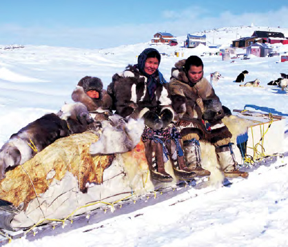
A family with a traditional qamutik (sled) in Cape Dorset, an Inuit hamlet in Nunavut, Canada. Source: Ansgar Walk


