


Below is the uncorrected machine-read text of this chapter, intended to provide our own search engines and external engines with highly rich, chapter-representative searchable text of each book. Because it is UNCORRECTED material, please consider the following text as a useful but insufficient proxy for the authoritative book pages.
26 APPROACH Geospatial research for transportation exists in pilot studies, individual technology analyses, and in-depth comparison projects. However, these results are scattered and reside in archives of research committees, university collaborations, or in-state organizationsâoften behind firewalls. This chap- ter reports the key findings and documented resources related to geospatial data, tools, and technologies. First, the data, tools, and technologies to be examined were chosen or excluded according to relevance to transportation agencies. Relevant data were then compiled and analyzed for common conclusions or contradictions. Lastly, these data were integrated into a structured, searchable, âliveâ database of available online resources. This Synthesis documents a variety of sources that may be of value to transportation agencies to support their cost- effective implementation of geospatial data, tools, technol- ogy, and information. With the vast quantity and types of geospatial research that currently exist, it would be impos- sible to include every source in a single, readable document. However, every effort was made to ensure key representa- tive reports, studies, and collaborations were included in the body of the report. Links to additional documents that are not discussed in this report can be found in Appendix C, the database of sources. Internet hyperlinks are used throughout the text of this document to provide the reader with quick access to refer- ence materials available online. These source links were veri- fied in August 2012. INFORMATION SOURCES Initially, researchers used the Internet to search for publicly available information and data from each state DOT. The rel- evant publications found and associated hyperlinks are listed in a database sorted by state and technology in Appendix C. In addition to specific DOT analysis, several other sources were valuable resources for investigating geospatial technol- ogy use in transportation agencies. These data have strengths and weaknesses specific to each source. For example, indus- try conferences can offer quick and specific information from several service providers; however, this information can be biased and often has not been peer reviewed. Conversely, journal publications typically have a lengthy review process, which improves the professional credibility of the findings, but the lag in publication can prove to be an issue with rap- idly evolving technologies. A list of typical advantages and disadvantages of the relevant information sources examined is presented in Table 6. Relevancy level definitions used in Tables 7 through 10 are as follows: I = focused directly on both transportation and geospatial technology; II = focused on either transpor- tation or geospatial technology; III = broader focus, some of which has relevance to transportation, geospatial tech- nology, or both. Agencies providing geospatial information are listed in Table 7, along with their corresponding relevance level to geospatial projects. These agencies can offer a starting point for research by transportation agency. Further, the information retrieved typically is current and presented for professionals associated with these specific industries. This requires a certain amount of peer and editorial review for verification. Many times the most current guidelines and specifications can be found at the websites of these agen- cies. Because these are agency-specific, they tend to pre- sent material in a manner that is beneficial to their particular agency, similar to a service provider workshop or confer- ence presentation. Continuing education through training sessions, work- shops, webinars, and conferences helps many transportation agency employees become technological leaders in their organizations. Many organizations discussed previously con- duct continuing education courses or have training at their regular meetings. Conference proceedings are valuable resources for learn- ing about or expanding knowledge of a certain technology or workflow. This can be a more cost-effective method of education than pilot studies or dedicated research projects. Organizations often find the cost and time associated with traveling to these conferences to be a limiting factor. In addi- tion, conference presentations often are not peer reviewed before presentation. Once at a conference, however, attendees may converse directly with a significant number of industry experts, attend chapter four LITERATURE REVIEW APPROACH
27 specific presentations on a tool or technique, and disseminate information quickly. Table 8 lists specific conferences rele- vant to geospatial proceedings and their associated relevancy level. In addition, several vendors have user meetings, which can be helpful to those wanting to learn about geospatial workflows and emerging technologies. Peer-reviewed technical journals usually contain some of the most in-depth documented findings of any research information source. These journals require thorough peer review of all research they publish. Most journals do not allow endorsement of or bias toward a particular vendor or service provider. They require the results of studies pub- lished in journals to be documented sufficiently to be repeat- able by someone else. Many journals also now promote data sharing. There tends to be a significant lag time between when a study is performed and its publication in a journal. In certain instances, manuscripts are accepted and published online before print versions are available. Certain journals have been selected and listed in Table 9 with their associated rel- evancy level. E-magazines, blogs, and open forum websites (Table 10) can be beneficial to a transportation agency entering into or evaluating current geospatial tools in use. These data sources tend to provide current information presented by a variety of Data Source Type Advantages Disadvantages Federal/State Agency ⢠Generally substantial internal (and sometimes external) review in development of published results ⢠Due to long review process, reports are under development for a long time ⢠Specific to the goals of the agency, limiting applicability State DOTs ⢠High relevance ⢠Needs-based undertakings ⢠Specific conclusions ⢠Can utilize pooled fund efforts for funding ⢠Some reports are not made publicly available ⢠Funding needs can limit scope and completion of work Conferences ⢠Ability to network and talk directly ⢠Quick dissemination ⢠Large number of experts with multiple views ⢠Can be costly to attend ⢠Travel restrictions ⢠May or may not be peer-reviewed ⢠Proceedings can sometimes be difficult to find Archival Journals ⢠Rigorous peer review process provides a check on the work and its quality ⢠Minimal bias toward a specific service provider ⢠Scientific methods of evaluation ⢠Generally requires rigorous statistical evaluations ⢠Significant lag in publication from research completion; however, many journals are publishing accepted manuscripts online before print versions are made available ⢠Difficult to keep up with the large number of journals E-magazines / Websites ⢠Quick information related to a variety of subjects ⢠Work presented by a variety of service providers ⢠Current information ⢠Generally not a lot of detail in how and how well work was performed ⢠Articles can contain service provider bias ⢠Not necessarily professionally reviewed White Papers ⢠Useful supplemental information ⢠Allows clarification on specific, sometimes recurring technical problems ⢠Quick publication ⢠Often not reviewed by an external audience ⢠Can be too general and may not include proprietary information ⢠Not archived TABLE 6 DATA SOURCE TYPE ADVANTAGES AND DISADVANTAGES
28 service providers and other industry leaders. However, these sources tend to be less formal and not peer reviewed, as are con- ference and journal sources. In addition, this information may contain service provider biases and often omits how informa- tion was obtained or evaluated (e.g., âtrade secretsâ). Vendors and service providers often have helpful documents on their websites regarding examples of technology implementation. A number of agencies and organizations are collecting geospatial data. It can be seen from the DOT questionnaire that DOTs are generally in support of a central clearinghouse to store and retrieve geospatial information (see Figure 19). Table 11 lists some of these clearinghouses and their website addresses. Additional information can be available through univer- sities or agencies funding or conducting research. In some cases, investigations for transportation agencies were per- formed by geospatial faculty and students in universities and have been incorporated into masters or doctorate theses, which are not easily obtainable through general search meth- ods. In many others, the research was funded by the univer- sity, governmental organizations, or one of the many other sources mentioned in this section. Agency / Organization Website Address Category American Association of State Highway Officials (AASHTO) http://www.transportation.org/ I American Congress on Surveying and Mapping (ACSM) (currently merging with NSPS) http://www.acsm.net/ III American Society for Testing and Materials (ASTM) http://www.astm.org/ III American Society of Civil Engineers (ASCE) Geomatics Division http://www.asce.org/Content.aspx? id=2147488648 II American Society of Civil Engineers (ASCE) Journal of Surveying Engineering http://ascelibrary.org/suo/ II American Society for Photogrammetry and Remote Sensing (ASPRS) http://www.asprs.org/ II Coalition of Geospatial Organizations (COGO) http://www.urisa.org/cogo II Federal Emergency Management Agency (FEMA) http://fema.gov II Federal Geographic Data Committee (FGDC) http://www.fgdc.gov I Federal Highway Administration (FHWA) http://www.fhwa.dot.gov I International Federation of Surveyors (FIG) http://www.fig.net/ II Highway Engineering Exchange Program (HEEP) http://www.heepweb.org I International Society for Photogrammetry and Remote Sensing (ISPRS) http://www.isprs.org/ II Joint Board of Geospatial Information Societies http://www.fig.net/jbgis II National Association of Counties (NACO) http://www.naco.org/Pages/default. aspx II National Geodetic Survey (NGS) http://www.ngs.noaa.gov/ II National Oceanic and Atmospheric Administration (NOAA) http://www.noaa.gov/ I Transportation Research Board (TRB) http://www.trb.org/Main/Home. aspx I United States Army Corps of Engineers (USACE) http://www.usace.army.mil/ II United States Department of Transportation (U.S.DOT) http://www.dot.gov/ I United States Geological Survey (USGS) http://www.usgs.gov/ I Surveyors and Geomatics Educators (SaGES) http://www.geoscholar.com/Sages/ III US Geospatial Transportation Mapping Association http://www.usgtma.org/ I State DOTs are listed separately. TABLE 7 AGENCIES WITH TRANSPORTATION AND/OR GEOSPATIAL TECHNOLOGY EXPERIENCE, CATEGORIZED BY RELEVANCE (STATE DOTs ARE LISTED SEPARATELY)
29 Conferences Website Address Category AASHTO GIS for Transportation Symposium http://www.gis-t.org/ I ASPRS http://www.asprs.org/ II ACSM Survey Summit (ESRI) http://www.surveysummit.com/index.html I European LIDAR Mapping Forum (ELMF) http://www.LIDARmap.org/ELMF/ III FIG http://www.fig.net/ II Highway Engineering Exchange Forum http://www.heepweb.org/ II Institute of Electrical and Electronics Engineers http://www.ieee.org/conferences_events/index.html III International LIDAR Mapping Forum (ILMF) http://www.LIDARmap.org/ILMF.aspx II ISPRS http://www.isprs.org/ II Institute of Transportation Engineers http://www.ite.org/conference/ II Photogrammetry Week Conference, University of Stuttgart, Germany http://www.ifp.uni- stuttgart.de/publications/phowo.en.html II SPAR http://www.sparpointgroup.com/ I TRB http://www.trb.org/Main/Home.aspx I TABLE 8 CONFERENCES WITH TRANSPORTATION AND/OR GEOSPATIAL TECHNOLOGY EXPERIENCE, CATEGORIZED BY RELEVANCE Publication Publishing Agency Website Address Category Annals of GIS Taylor and Francis www.tandf.co.uk/journals/tagi II ASTM Testing Journal ASTM http://www.astm.org/ II GeoCarto International Taylor and Francis www.tandf.co.uk/journals/tgei II International Journal of Photogrammetry and Remote Sensing (ISPRS) ISPRS http://www.isprs.org/ II Journal of Computing in Civil Engineering ASCE http://ascelibrary.org/journal/jccee5 I Journal of Spatial Science Taylor and Francis www.tandf.co.uk/journals/tjss II Journal of Surveying Engineering ASCE http://ascelibrary.org/suo/ I Journal of Transportation Engineering ASCE http://ascelibrary.org/journal/jtpedi II Lasers in Engineering Old City Publishing http://www.oldcitypublishing.com/LIE/LIE.html II Photogrammetry Engineering and Remote Sensing ASPRS http://www.asprs.org/ II Remote Sensing MDPI http://www.mdpi.com/journal/ remotesensing II Survey and Land Information Sciences (SALIS) ACMS (NSPS) http://www.acsm.net/ II Transactions on Geoscience and Remote Sensing IEEE http://www.grss- ieee.org/publications/transactions/ II Transportation Research Record (TRR) TRB http://www.trb.org/Main/Home.aspx I TABLE 9 JOURNALS WITH TRANSPORTATION AND/OR GEOSPATIAL TECHNOLOGY EXPERIENCE, CATEGORIZED BY RELEVANCE
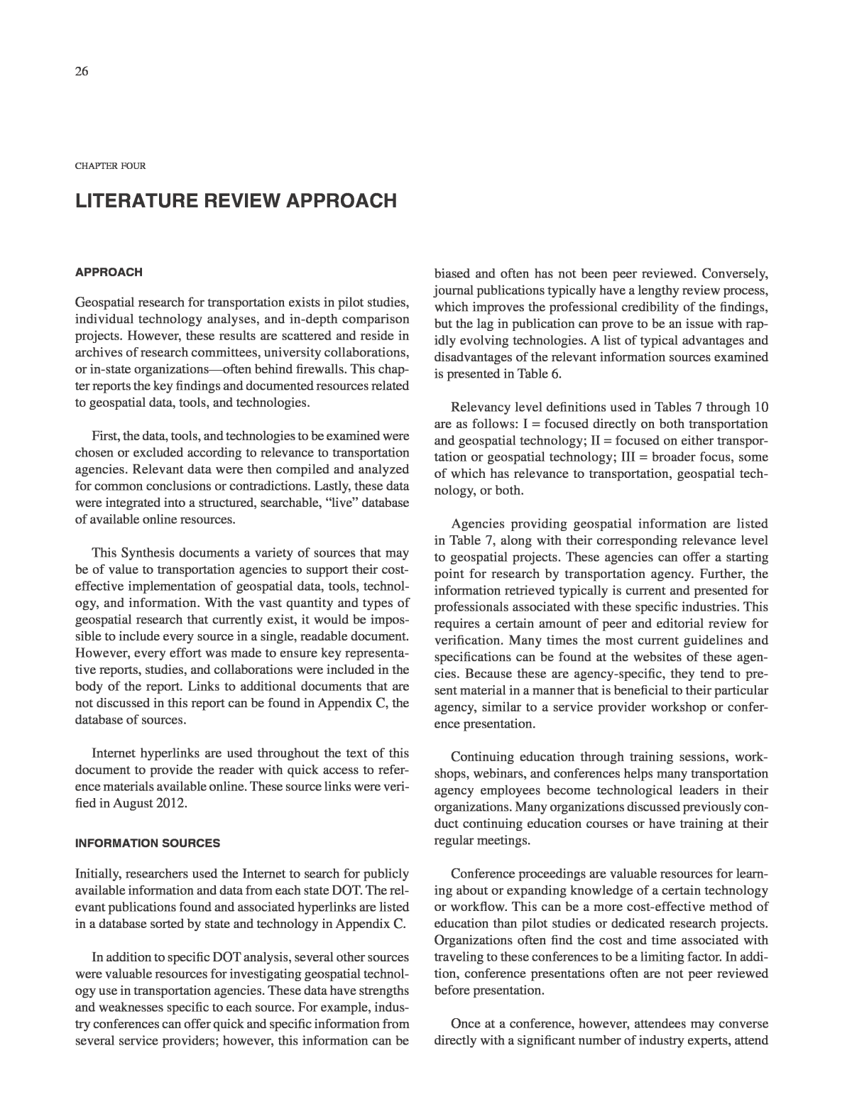
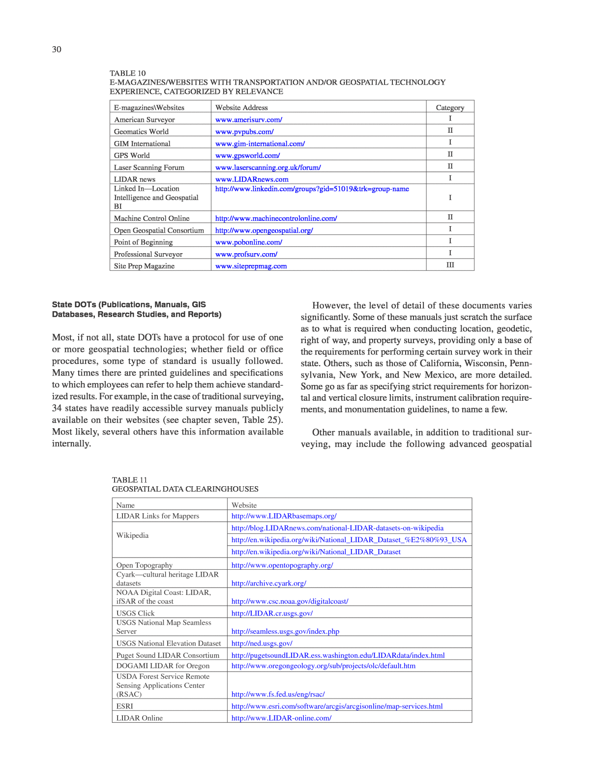
30 State DOTs (Publications, Manuals, GIS Databases, Research Studies, and Reports) Most, if not all, state DOTs have a protocol for use of one or more geospatial technologies; whether field or office procedures, some type of standard is usually followed. Many times there are printed guidelines and specifications to which employees can refer to help them achieve standard- ized results. For example, in the case of traditional surveying, 34 states have readily accessible survey manuals publicly available on their websites (see chapter seven, Table 25). Most likely, several others have this information available internally. However, the level of detail of these documents varies significantly. Some of these manuals just scratch the surface as to what is required when conducting location, geodetic, right of way, and property surveys, providing only a base of the requirements for performing certain survey work in their state. Others, such as those of California, Wisconsin, Penn- sylvania, New York, and New Mexico, are more detailed. Some go as far as specifying strict requirements for horizon- tal and vertical closure limits, instrument calibration require- ments, and monumentation guidelines, to name a few. Other manuals available, in addition to traditional sur- veying, may include the following advanced geospatial E-magazines\Websites Website Address Category American Surveyor www.amerisurv.com/ I Geomatics World www.pvpubs.com/ II GIM International www.gim-international.com/ I GPS World www.gpsworld.com/ II Laser Scanning Forum www.laserscanning.org.uk/forum/ II LIDAR news www.LIDARnews.com I Linked InâLocation Intelligence and Geospatial BI http://www.linkedin.com/groups?gid=51019&trk=group-name I Machine Control Online http://www.machinecontrolonline.com/ II Open Geospatial Consortium http://www.opengeospatial.org/ I Point of Beginning www.pobonline.com/ I Professional Surveyor www.profsurv.com/ I Site Prep Magazine www.siteprepmag.com III TABLE 10 E-MAGAZINES/WEBSITES WITH TRANSPORTATION AND/OR GEOSPATIAL TECHNOLOGY EXPERIENCE, CATEGORIZED BY RELEVANCE Name Website LIDAR Links for Mappers http://www.LIDARbasemaps.org/ Wikipedia http://blog.LIDARnews.com/national-LIDAR-datasets-on-wikipedia http://en.wikipedia.org/wiki/National_LIDAR_Dataset_%E2%80%93_USA http://en.wikipedia.org/wiki/National_LIDAR_Dataset Open Topography http://www.opentopography.org/ Cyarkâcultural heritage LIDAR datasets http://archive.cyark.org/ NOAA Digital Coast: LIDAR, ifSAR of the coast http://www.csc.noaa.gov/digitalcoast/ USGS Click http://LIDAR.cr.usgs.gov/ USGS National Map Seamless Server http://seamless.usgs.gov/index.php USGS National Elevation Dataset http://ned.usgs.gov/ Puget Sound LIDAR Consortium http://pugetsoundLIDAR.ess.washington.edu/LIDARdata/index.html DOGAMI LIDAR for Oregon http://www.oregongeology.org/sub/projects/olc/default.htm USDA Forest Service Remote Sensing Applications Center (RSAC) http://www.fs.fed.us/eng/rsac/ ESRI http://www.esri.com/software/arcgis/arcgisonline/map-services.html LIDAR Online http://www.LIDAR-online.com/ TABLE 11 GEOSPATIAL DATA CLEARINGHOUSES
31 technologies: aerial mapping and photogrammetry, LIDAR specifications, guidelines and best practices, and ROW manuals. These can exist as stand-alone documents, such as those for New York, Connecticut, and Massachusetts. Other states (Indiana and Missouri) prefer to have a large manual divided into sections with each technology generally dis- cussed in a dedicated chapter or two. Several states (includ- ing Montana, North Dakota, and Florida) have a manuals page that contains hyperlinks to many manuals, with topics ranging from erosion and sediment control, to traffic control devices, to photogrammetric standards. Often these manuals and standards exist in specific departmental locations and on a general manuals page, so a person can navigate to these documents through multiple paths. Having these documents accessible rather than hidden provides more freedom to employees, consultants, other DOTs, and the general public to obtain information such as accuracy standards and best practices quickly and easily for quality assurance/quality control (QA/QC) checks. State databases utilizing numerous GIS platforms are becoming standard practice for providing geospatial data to the public. These platforms allow states to display their data with satellite imagery and topographic backgrounds to create relevant, interactive, online tools. These tools provide end users with answers to geospatial-related queries in a mat- ter of seconds. End users may be the general public, DOT employees, other state and federal agency employees, or private businesses. Some of the numerous examples of GIS integration by transportation agencies include land bound- aries; crash statistics; current, planned, and completed building projects; weather; traffic; utilities; topography; railroads; and zoning. This information can exist as separate applications or in collective data clearinghouses in some cases. Examples of states with GIS clearinghouses are Georgia, Illinois, South Carolina, Oregon, and Maine. Several states also include advanced data, such as LIDAR, orthorectified photography, and aerial imagery along with these GIS layers. Research studies for the advancement of geospatial tech- nologies have been undertaken by several states. In addition, studies are performed by some transportation agencies to analyze technologies in use to seek enhancement techniques and evaluate the ROI. Sometimes these research studies are collaborative efforts with pooled funding from multiple transportation agencies, enabling states to share resources and accomplish a common or similar analytical goal that can be provided by dedicated research. Collaborations also have the luxury of bringing in outside consultants to aid with their expertise. No matter how funding is gained, synthesizing these data will be a great benefit to all who look to enter new technology platforms or analyze their current use of advanced geospatial technologies. CURRENT INITIATIVES Fortunately, geospatial technologies recently have received more national attention. MAP-21, the Moving Ahead for Prog- ress in the 21st Century Act (P.L. 112-141), was recently signed into law to fund surface transportation programs at a cost of more than $105 billion for fiscal years (FY) 2013 and 2014. This legislation is quite forward looking. In addition to an emphasis on the use of performance-based versus prescrip- tive specifications, MAP-21 includes financial incentives for the use of 3D technology. In particular, Section 1304 of the legislation authorizes as much as 100% federal financing for projects that contain inno- vative technologies such as âdigital 3-dimensional modeling.â In addition, the FHWA is also promoting the use of 3D through its Every Day Counts (EDC)âDC initiative. This program is âdesigned to identify and deploy innovation aimed at shortening project delivery, enhancing the safety of our roadways, and protecting the environment.â In the recently announced second round of initiatives, 3D modeling, geo- spatial data collaboration, and GPS-based intelligent compac- tion are highlighted. As evidence of the connection, the Utah DOTâs use of mobile mapping to create what they are calling âuPlanâ has been identified as one of the second round of EDC initiatives. The database for this 3D asset management system was col- lected using a variety of sensors, including Mobile LIDAR. This program has the potential to become a model for transpor- tation agencies here in the United States and around the world.
