


Below is the uncorrected machine-read text of this chapter, intended to provide our own search engines and external engines with highly rich, chapter-representative searchable text of each book. Because it is UNCORRECTED material, please consider the following text as a useful but insufficient proxy for the authoritative book pages.
83 9.1 Introduction: Case Study Approach Case studies were prepared for six airports that have designed and implemented compensa- tory wetland mitigation projects. The selected airports are in different FAA regions and vary in size, geographic settings, local weather conditions, types of wetland mitigation projects, and levels of airline service. Data collected from the airports included the type and quantity of wet- land impacts that necessitated the mitigation, permits required, the detailed mitigation plan implemented, and the challenges associated with the mitigation project. The goals of the case studies included identifying the approval and implementation processes for both on-site and off-site mitigation plans as well as identifying both successes and challenges associated with the mitigation plans. Specific data collected include the following information: ⢠Wetland types impacted; ⢠Impact size; ⢠Mitigation type used (on-site, off-site, creation/replication, restoration, preservation, in-lieu- fee/wetland banking, etc.); ⢠Federal, state, or local constraints encountered during the project approval, design, construc- tion, property acquisition, and/or maintenance phases of the project; ⢠Total project cost and sources of funding, wherever available; ⢠The decision process used by the airport to select the method of mitigation; ⢠Required design modifications; ⢠Project timelines from the strategic planning and scoping phases through construction and post-construction monitoring; ⢠Post-construction monitoring requirements and ongoing maintenance needs or issues; and ⢠Where available, any local response to the project and any stakeholder interfacing that may have occurred. The six selected case study airports are: ⢠Cecil Airport: Jacksonville, Florida; ⢠La Crosse Regional Airport: La Crosse, Wisconsin; ⢠Manchester-Boston Regional Airport: Manchester, New Hampshire; ⢠Nut Tree Airport: Solano County, California; ⢠Pullman-Moscow Regional Airport: Whitman County, Washington; and ⢠Denver International Airport: Denver, Colorado. C H A P T E R 9 Case Studies
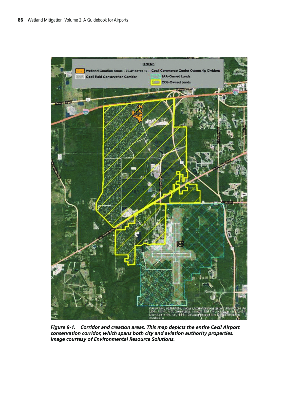
84 Wetland Mitigation, Volume 2: A Guidebook for Airports 9.2 Case Study #1: Cecil AirportâMaster Plan Development and Mitigation In support of planned development for the new Cecil Airport and Cecil Commerce Center, the City prepared a master plan for the former military property. Field studies identified impacts to more than 500 acres of jurisdictional wetlands, one-third of which occurred within airport boundaries. The City worked with several federal, state, and local agencies to develop aviation-compatible mitigation through a combination of on-site wetland preservation and creation projects that also contributed to regional conservation efforts. Cecil Airport is located approximately 20 miles west of Jacksonville, Florida, within the FAAâs Southern Region. It was formerly a U.S. Navy Base (Cecil Field Naval Air Station), which was closed under the federal Defense Base Realignment and Closure Act of 1993. Upon closure, the former base was turned over to the City of Jacksonville (COJ) and the Jacksonville Aviation Authority (JAA). The COJ owns and operates the Cecil Commerce Center (CCC) to the north and the JAA owns and operates Cecil Airport, the southern portion of the property. The airport is approximately 6,000 of the total 17,000 acres and currently has 93 based aircraft and experi- ences more than 100,000 aircraft movements annually (approximately 286 movements per day). Runway 18L-36R is the primary runway, oriented north/south, and is 12,504 feet by 200 feet. Run- way 9R-27L is the secondary runway, perpendicular to the primary runway, and is 8,000 feet by 200 feet. Each runway has a shorter parallel runway, 18R-36L and 9L-27R, respectively. The airport has an active flight training community with on-site military and civilian GA training facilities. GA flights (both local and transient) make up 48 percent of total aircraft movements at the airport, with military operations accounting for the remaining 52 percent. 9.2.1 Wetland Impacts and Permitting In 1999, the COJ and JAA initiated master plans for their respective properties. As part of the master planning efforts, the COJ and JAA undertook a comprehensive effort to identify, assess, and map jurisdictional wetlands throughout the approximately 17,000-acre former mili- tary property. To assess wetland quality, the City, the JAA, and their consultants completed a WRAP. The WRAP included coordination among several agencies including the USACE, USFWS, USEPA, and the St. Johns River Water Management District (SJRWMD). Between the COJ and JAA, implementing the proposed master plans would lead to more than 500 acres of wetland impacts for which mitigation would be necessary. The JAA master plan identified approximately 1,900 acres of airport development and envisioned the construction of additional GA facilities (hangars, pavements, etc.), a spaceport, and other infrastructure that would impact 164 acres of jurisdictional wetlands. To facilitate development during the master planâs 20-year horizon, the COJ and JAA worked with the USACE to obtain a 20-year individual permit for conceptual plan development through- out the property (the CCC and airport). As individual project designs are prepared in the years to come, the COJ and JAA (or leasehold developers) will obtain general or individual permits and provide mitigation on a project-by-project basis. The USACE will modify the individual permit to reflect changes to the conceptual plan. 9.2.1.1 Mitigation and Challenges The abundance of on-site wetlands and the substantial mitigation requirements associated with proposed master plan development presented challenges for the COJ, the JAA, and agencies involved in wetland permitting/mitigation. Unlike other developers, airport operators are fre- quently unable to implement wetland avoidance and minimization strategies because of facility siting requirements and the need to prevent wildlife hazards to aircraft operations.
Case Studies 85 9.2.1.2 Airport Facility Location and Design The locations of many necessary aviation facilities, such as lighting and other navigational aids, are fixed by function. The FAA provides strict guidance on the location of navigational aids and other facilities based on their relation to runways, approach and departure surfaces, and other facilities in AC 150/5300-13A, Airport Design. The location of many airport facilities identified in the master plan could not be adjusted to avoid or minimize wetland impacts. 9.2.1.3 Wildlife Hazard Management The FAA discourages the construction of new water features, including stormwater manage- ment facilities and wetland mitigation sites, within the critical zone for wildlife hazards. The critical zone is defined as the area within 10,000 feet from the nearest operations area for turbine- powered aircraft and the area within 5,000 feet for piston-powered aircraft, because such features could attract wildlife and lead to conflicts (strikes) with aircraft. Therefore, airports are further discouraged from preserving or creating wetlands on site, pursuant to FAA AC 150/5200-33B. 9.2.2 Mitigation Summary To help satisfy compensatory mitigation requirements, COJ and JAA undertook a multi- faceted approach to mitigate for wetland impacts throughout the 17,000-acre property. The approach included obtaining appropriate permits and implementing a comprehensive mitiga- tion plan composed of wetland preservation, upland preservation, and on-site wetland creation in a location compatible with airport operations. 9.2.2.1 Corridor Management Plan: Wetland & Upland Preservation The COJ, JAA, and their consultants undertook extensive outreach and coordination with the U.S. Department of Agriculture, Division of Forestry, and the COJ Parks and Recreation Depart- ment to develop a corridor management plan on the approximately 5,900-acre area along the western property boundary. The corridor management plan documented a commitment to pre- serving and managing the corridor in perpetuity through a conservation easement that would serve as mitigation for a portion of the identified wetland impacts. The USACE, USEPA, USFWS, and SJRWMD approved the corridor management plan. Representatives of the COJ, JAA, surround- ing municipalities, SJRWMD, and the Florida Department of Environmental Protection signed a memorandum of understanding to document their commitment to preserving the corridor. 9.2.2.2 Wetland Creation In addition to preservation, the COJ and JAA committed to construction of 100 acres of on-site forested wetland creation in the conservation corridor. Currently, 72 acres are con- structed in four non-contiguous upland parcels (see Figure 9-1). At its nearest point, the created wetlands are approximately 25,000 feet from the air operations area. The remaining 28 acres of creation will be sited in an appropriate location on JAA property. 9.2.2.3 Furthering Regional Conservation Efforts The corridor management plan is more than the sum of its parts. In addition to providing compensatory mitigation for COJ and JAA master plan development, the corridor also con- tributes to a regional plan to create and maintain an approximately 35-mile wildlife corridor through the state of Florida. The corridor preservation/management project serves many functions, as follows: ⢠Preserves the corridorâs unique resources including abundant wetlands and extensive, rela- tively undisturbed upland forests;
86 Wetland Mitigation, Volume 2: A Guidebook for Airports Figure 9-1. Corridor and creation areas. This map depicts the entire Cecil Airport conservation corridor, which spans both city and aviation authority properties. Image courtesy of Environmental Resource Solutions.
Case Studies 87 ⢠Provides opportunities for passive, natural resource-based public recreation and forestry management that can be integrated with the adjacent Cary and Jennings State Forests; ⢠Contributes to a larger natural wildlife area that extends southward from I-10 and provides a link to the Jennings State Forest, Brannan Field Mitigation Park, and Camp Blanding; and ⢠Provides an opportunity for limited revenue to the airport through sound forestry manage- ment by the Division of Forestry, including the harvest of upland forest products under a long-term plan that includes provisions for stand rotation and wetland buffers. The total on-site mitigation plan comprises approximately 5,900 acres, including: ⢠1,922 acres of wetland preservation, ⢠3,861 acres of upland preservation, and ⢠100 acres of on-site wetland creation. 9.2.2.4 Mitigation Status To date, the City has constructed 72 acres of on-site wetlands and obtained permits to con- struct the remaining 28 acres by 2021. The wetland creation sites were selected based on access, contiguity with existing wetlands (preservation areas), constructability, and likelihood of success. In April 2012, more than 31,000 native trees were planted including bald cypress (Taxodium distichum), pop ash (Fraxinus caroliniana), red maple (Acer rubrum), black gum (Nyssa sylvatica var. biflora), sweetgum (Liquidambar styraciflua), and sweet bay magnolia (Magnolia virginiana). The required 5-year monitoring period (for the 72-acre area) concluded in 2017 and the mitigation was determined to be a success. (See Figures 9-2 through 9-5.) 9.2.3 Involved Agencies and Other Stakeholders ⢠FAA (Southern Region) ⢠EPA ⢠USACE ⢠USFWS ⢠Florida Department of Environmental Protection ⢠Florida Fish and Wildlife Conservation Commission Figure 9-2. Wetland mitigation site after grading. Photo courtesy of Environmental Resource Solutions.
88 Wetland Mitigation, Volume 2: A Guidebook for Airports Figure 9-3. Wetland mitigation site 1 year after planting. Photo courtesy of Environmental Resource Solutions. Figure 9-4. Wetland creation area 1, 2 years after planting. Photo courtesy of Environmental Resource Solutions. ⢠Florida Division of Forestry ⢠SJRWMD ⢠COJ ⢠JAA 9.2.4 Project Outcome The airport succeeded in acquiring permits for a total plan of development from the SJRWMD and USACE. While the plan is conceptual and continually evolves to meet current market demand, having an overall permit that can be modified as appropriate expedites process- ing future construction needs.
Case Studies 89 The JAA specifically coordinated with the SJRWMD, USACE, and the FAA to develop mutually acceptable conservation easement language. The first FAA-approved conservation easement was recorded in early 2009, and subsequent easements have been approved and recorded. The con- servation language was written to provide ongoing wildlife hazard management for Cecil Airport and compliance with Federal Aviation Regulation (FAR) Part 77, âSafe, Efficient Use, and Pres- ervation of the Navigable Airspace.â This project highlights the need for, and intricacies of, bal- ancing site development with safe aircraft operations, resource protection, and FAA compliance. Moreover, the COJ and JAA comprehensive approach to the wetland mitigation plan saved more than $20M when compared to the cost of providing mitigation at an off-site mitigation bank. 9.2.5 Approximate Costs ⢠Planning/Design/Permitting: $150,000 ⢠Construction of Mitigation Site: $1,500,000 to construct 72.49 acres of wetland creation ⢠Post-Construction Monitoring: $100,000 (wetland creation only) ⢠Ongoing Maintenance: Variable (Timber management fees are offset by timber revenue.) 9.2.6 Source(s) of Funding ⢠COJ 65% ⢠JAA 35% 9.2.7 Timeframe ⢠Design/Permitting: 2 years (initial) ⢠Construction of Wetland Creation Site: 72.49 acres complete, 27.51 acres remain to be constructed within the next 4 years ⢠Monitoring: Ongoing; majority will be completed in fall 2017, all monitoring will be com- pleted by 2021 Figure 9-5. Wetland creation area 2, 2 years after planting. Photo courtesy of Environmental Resource Solutions.
90 Wetland Mitigation, Volume 2: A Guidebook for Airports 9.3 Case Study #2: La Crosse Regional Airportâ Taxiway F Relocation Project The relocation of this taxiway resulted in impacts to wetlands and a fishery, both located within a National Wildlife Refuge. As a result, the unique challenges for mitigation included an extensive search to identify and ultimately select two sites (one for each impact) rather than one, and work- ing around the regionâs natural, surrounding terrain. Another feature of this successful mitigation was the identification of long-term stewardship of the two sitesâthe City of La Crosse taking over the fishery mitigation located in a city park that had involved a new open water connection to the Mississippi River, and a conservancy taking over stewardship of the wetland mitigation bank site, which was adjacent to their property. La Crosse Regional Airport is an air-carrier airport located in La Crosse, Wisconsin. The air- port is on French Island near the eastern bank of the Mississippi River, surrounded by waters, wetlands and floodplain forests of the Upper Mississippi River National Wildlife and Fish Refuge (refuge). The airport is in the FAA Great Lakes Region, covers 1,380 acres, and has three runways. The main runway, Runway 18-36, is 8,742 by 150 feet and is the fourth-longest in the state. Runway 13-31 is 6,050 by 150 feet while Runway 3-21 is 5,199 by 150 feet. The airport has a modern two-story passenger terminal with three gates, and passenger service is provided by Delta and American Eagle airlines. There are 11 corporate hangars and eight multi-aircraft T-hangars on the airport property. For the 12-month period ending December 31, 2015, the airport had 26,303 aircraft operations, an average of 72 per day: 68 percent GA, 24 percent air taxi/airline, and 8 percent military. In March 2017, there were 74 aircraft based at this airport: 60 single engines, four multi-engine, eight jets, and two helicopters. The Taxiway F relocation project involved construction of a 3,850-foot taxiway on the west side of Runway 18. The projectâs purpose was to end potential runway incursions from the old taxiway geometry that was an artifact of airport development over the past several decades. The project began in 2003 with a NEPA EA and continued with project design, engineering, mitiga- tion, monitoring, management, and final disposition of mitigation sites in 2014. Participatory funding from the FAA Great Lakes Region, Wisconsin Bureau of Aeronautics (WBOA) and the City of La Crosse continued via several grants throughout this period. The total project cost of the taxiway and associated mitigation was $13,000,000. 9.3.1 Wetland Impacts and Permitting The necessary Taxiway F geometry had a minimized impact of 8.64 acres on riparian wet meadows and aquatic bed wetlands of Lake Onalaska. This lake has among the best sport- and pan-fishery resources in the Upper Midwest. The lake is a National Wildlife Refuge system and an important place where migratory waterfowl rest and feed with up to 300,000 waterfowl counted by refuge staff on single days during migration. Agencies identified the particular area of impact as an important fish breeding and nursery area, dominated by floating-leaved aquatic vegetation. The consultant minimized wetland impacts while adhering to FAA design criteria for the maximum slopes allowed. Also, dredging operations were seasonal to minimize impacts to breeding fish and amphibians. The permitting agencies consisted of the USACE, the WDNR and the USFWS. Because of the high ecological profile of the impacted ecosystem and its function as part of a National Wildlife and Fish Refuge as well as the main aquatic resource of the Central Flyway for migratory birds, the Individual Section 404 permit required the following mitigation criteria: ⢠Wetland banking could not be used. Available wetland banks did not provide suitable wetland habitat or function to compensate for loss, and they were remote from the project;
Case Studies 91 ⢠Wetland mitigation must occur within 2.5 miles of the Mississippi River to compensate for lost wetland functions within the Mississippi River corridor of the Central Flyway; ⢠USFWS policy is that wetland mitigation could not occur within the confines of the refuge, which occupies 240,000 acres over 260 miles of the Upper Mississippi River and adjacent floodplains; and ⢠The mitigation plan must include restoration of an equivalent area of fishery habitat lost to the project (approximately 6 acres). The regional terrain made mitigation even more challenging, as the surrounding six Wiscon- sin counties adjacent to the Mississippi River were unglaciated terrain characterized by well- drained uplands with deeply incised valleys generally lacking hydric soils as well as converted wetland areas suitable for restoration. The extent of the refuge and the requirement to mitigate outside of it made identifying a fishery restoration site even more challenging. It took several years of evaluating 40 wetland restoration areas in seven counties to locate a suitable mitigation site. The site, now called the Sugar Creek Wetland Mitigation, was converted wetland with a drain tile system on a creek terrace located within the Village of Ferryville, 42 miles south of the project and less than 1,000 feet from the Mississippi River. At the same time, a fishery mitiga- tion project was identified in Pettibone Park on Barron Island within the Mississippi River and surrounded by the refuge, but on lands owned by the City of La Crosse. 9.3.1.1 Sugar Creek Wetland Mitigation The wetland mitigation parcel totaled 22 acres, including 10 acres of abandoned hayfield on converted wetland and 12 acres of mature hardwood forest on adjacent slopes. The parcel is on the west bank of Sugar Creek, a trout stream and first order tributary of the Mississippi River, which means it is the smallest size tributary. Sugar Creek drains about 11 miles of steep east-west trending forested coulee terrain. Several residences bordered the woodlands west of the site, while to the northeast it shares a boundary with the 430-acre Sugar Creek Bluff State Natural Area. This area is owned by the Mississippi Valley Conservancy (MVC), a non-profit land trust. The site is 42 miles south of the airport. See Figures 9-6 through 9-8. The consultant team considered the Sugar Creek site suitable for restoration after water table readings and deep soil borings showed absence of wetland hydrology and the presence of over Figure 9-6. Site planted but prior to vegetation growth in 2010. Photo courtesy of Mead & Hunt.
92 Wetland Mitigation, Volume 2: A Guidebook for Airports 12 feet of modern silty alluvium over a pre-settlement hydric soil. Investigations showed that a carefully designed excavation within the deepwater table of the silty alluvium would yield a groundwater-sustained hydrology because of the hydrologic regime sustained by the adjacent cold-water creek. The grading plan design provided an inclined wet meadow above a semi-elliptical waterfowl pond designed to provide pairing, loafing, and foraging habitat with a combination of sub- merged and floating-leaved aquatic bed and littoral wetlands near the shoreline similar to the impacted area. Recognizing that the groundwater contact characteristics of the wet meadow could provide fen (marsh-like) habitat, the wetland scientists developed an extremely diverse seeding and planting specification with 146 native plant species in reference to historical data on fen and wet meadow habitats in the region. The consultant team developed a Hydrologic Figure 9-7. Live stakes at the stream growing at the stream and site interface. Photo courtesy of Mead & Hunt. Figure 9-8. After seed growth in 2013. Photo courtesy of Mead & Hunt.
Case Studies 93 Engineering Center River Analysis System (HEC-RAS) flood model of Sugar Creek to dem- onstrate to the village the effect on the 100-year floodplain if no mitigation was done as well as to design a return-flow pipe to the creek. This pipe was sized to drain a 10-year flood within 24 hours and protect the wet meadow from excessive siltation in the water. At 10 acres, the site was smaller than the acreage required by the agencies. Despite its size, the agencies agreed to accept it as mitigation and assign remaining credit needs to a Wiscon- sin Department of Transportation (WisDOT) statewide mitigation bank in light of the excep- tional effort to achieve high-quality mitigation on the site. MVC facilitated site acquisition, and also partnered with the WisDOT Bureau of Aeronautics on a separately funded agreement to perform wetland management during the 5-year post-restoration monitoring period. Site construction occurred in fall of 2009 and spring of 2010. The site was monitored and man- aged through 2014 with project funding. Groundwater recording wells were installed each year to monitor water levels. The plant community data were analyzed using a quantitative sampling approach that used relative cover, relative frequency, and established coefficients of conservatism for native species and negative integers for invasive exotic plants in order to arrive at a single qual- itative metric to compare with an established performance standard. This approach also allowed a means to track the effectiveness of management actions to control invasive plant species. The consultant discussed annual monitoring results at an annual meeting with the airport, USACE, WDNR, and MVC. Performance standards began to be met by 2011, and by 2014 the project had exceeded all performance criteria by significant degrees, with vegetation comparable to pre-settlement fens and wet meadows of high quality (see Figures 9-9 and 9-10). After project close- out, a permanent conservation easement was established on the site and the WisDOT Bureau of Aeronautics transferred title to MVC for incorporation to the Sugar Creek Bluff State Natural Area. 9.3.1.2 Pettibone Park Fishery Mitigation On Barron Island in the Mississippi River, the City owns and maintains the 167-acre Pettibone Park that contains a 19-acre lagoon with a narrow connection to the Mississippi River. Accord- ing to WDNR fishery staff, the lagoon had a chronic history of fish kills during winter when ice covered the water surface (ice-on conditions) because the narrow connection was insufficient to Figure 9-9. Just Constructed, March 2010. Mitigation site immediately after construction. Photo courtesy of Mead & Hunt.
94 Wetland Mitigation, Volume 2: A Guidebook for Airports maintain a supply of oxygenated water from the river. The 404 permitting team, which consists of the WDNR, the USFWS, and the USACE, considered alleviation of this problem an acceptable form of fishery mitigation and the consultant team studied various alternatives. Excavation of a new open water connection to the river was not possible due to impacts to historic structures and park facilities, so a buried pumped-water system was designed instead. The Pettibone Park lagoon is 5 miles south of the airport. The WDNR established a goal of 5 milligrams per liter (mg/l) of dissolved oxygen (DO) during ice-on conditions, using pumped water from the river with a general winter content of 12 mg/l DO. The WDNR fisheries staff undertook a cooperative study that modeled oxygen consump- tion and water inputs. The study established that a constant inflow of 5 cubic feet per second would meet this performance standard. Therefore, the consultant team designed a redundant system of two submerged pumps, so that a pump was working at all times, each capable of pro- viding this flow. A submerged intake in the river supplied water to a concrete sump, from which two buried outlet pipes ran to a submerged location in the north end of the lagoon. A key facil- ity within the system was a local control station, which was built above the 100-year flood base flood elevation. The system had a remote alarm to alert City staff in the event of a power failure. Construction of the Pettibone pumped water system occurred in 2010 and staff monitored the DO levels through the ice each winter season through 2014. Initial monitoring showed DO levels up to 9 mg/l, which WDNR staff inferred might be caused by too high a pump setting. These levels would lead to adverse current conditions for over-wintering fish. The ongoing monitoring enabled the pump settings to be adjusted gradually to arrive at the required balance of oxygen and current conditions. The success of the project has been confirmed by a continuing absence of fish kills since construction, and anecdotes from local anglers on the quality of ice fishing at the lagoon. The facility was handed off to the City in 2014, with an on-site operations and mainte- nance training session run by the consultant and the pump vendor. (See Figures 9-11 and 9-12.) 9.3.2 Mitigation Summary Mitigation for the wetland impacts included the following: ⢠Restoration of approximately 10.1 acres of wet meadow, shallow marsh, and aquatic bed wetland; Figure 9-10. Same View, 2014. Mitigation site flourishing. Photo courtesy of Mead & Hunt.
Case Studies 95 ⢠Preservation of the restored wetlands and approximately 12 acres of adjacent forested buffer by incorporation into the Sugar Creek Bluff State Natural Area; and ⢠Restoration of 19 acres of over-wintering Mississippi River fishery habitat in Pettibone Park via construction of a pumped-water supply system for supplying oxygenated water during the ice-on season. 9.3.3 Involved Agencies and Other Stakeholders ⢠FAA (Great Lakes Region) ⢠USACE ⢠WDNR ⢠Wisconsin State Historic Preservation Office (WSHPO) Figure 9-12. Standard equipment. Photo courtesy of Mead & Hunt. Figure 9-11. Lightweight seeder and skid steer used during wetland construction to prevent rutting and damage to the surface layer that standard equipment would cause. Photo courtesy of Mead & Hunt.
96 Wetland Mitigation, Volume 2: A Guidebook for Airports ⢠City of La Crosse ⢠MVC 9.3.4 Project Outcome The project outcomes were entirely successful for two main reasons: first, because of the cooperative stewardship relationship fostered between the agencies, the consultant, and MVC on the wetland restoration; and second, because of the cooperative scientific analysis contrib- uted by WDNR fisheries on the design and operation of the Pettibone fishery mitigation proj- ect. Creative and proactive project administration by the FAA, WisDOT BOA, and the City of La Crosse throughout the project also contributed significantly to project success. 9.3.5 Approximate Cost Planning/Design/Permitting ⢠Fishery mitigation site: $164,000 ⢠Wetland mitigation site: $126,000 Construction of Mitigation Sites ⢠Fishery mitigation site: $376,000 ⢠Wetland mitigation site: $842,000 Post-Construction Monitoring ⢠Fishery mitigation site: $92,000 ⢠Wetland mitigation site: $164,000 Note: Site selection studies are not included in costs. 9.3.6 Source(s) of Funding ⢠FAAâ90% ⢠WBOAâ5% ⢠City of La Crosseâ5% 9.3.7 Timeframe ⢠Design/Permitting: 7 years ⢠Construction of Mitigation Sites: 1 year ⢠Monitoring: 5 years 9.4 Case Study #3: Manchester-Boston Regional Airportâ Runway 24 Safety Area Improvement Project The Runway 24 project resulted in impacts to jurisdictional wetlands. The impacts were mini- mized by the construction of an engineered material arresting system (EMAS) that allowed a 400-foot reduction of the runway safety area. The final mitigation package included the restoration/ creation of 4.3 acres of compensatory wetlands, the preservation of 20 acres of wetlands and adjacent upland, and payment of $200,000 to the state in-lieu-fee fund. Manchester-Boston Regional Airport (MHT or the airport) is a publicly owned, small-hub airport located in the municipalities of Manchester and Londonderry, New Hampshire. The
Case Studies 97 airport covers approximately 1,200 acres and is located in the FAA New England Region. MHT has four commercial airlines as well as two cargo carriers and approximately 65 based aircraft. There are two runways: Runway 17-35 (9,250 feet) and Runway 6-24 (7,651 feet). MHT had approximately 51,000 operations in 2016. The purpose of the Runway 24 Safety Area Improvement project was to improve the run- way safety area (RSA) for the approach end of Runway 24 to meet FAA safety criteria. The project included the construction of an engineered material arresting system (EMAS) along with a paved RSA. In order to extend the RSA, the relocation of South Willow Street and the reconfiguration of the intersections on each end of the project were necessary. The project also called for a vehicle service road to be constructed around the new RSA. The completed RSA was approximately 600 feet long and began just east of a 77-foot extension to the existing runway. The placement of fill material was such that the RSA sat above the existing topography. Project planning and design began during the preparation of the Airportâs Master Plan Update in 1997, a process that evaluated six alternative runway alignments. The required NEPA EA fur- ther evaluated the six alternatives. After consulting with the FAA and the project consultants, the airport chose the preferred alternative, which included the EMAS option, as the best practicable alternative to avoid and minimize wetland impacts. Final planning and design of the project commenced in 2005. Construction of the project and the mitigation site occurred in 2007. 9.4.1 Wetland Impacts and Permitting The project permanently impacted approximately 5.2 acres of wetland from fill associated with the construction of an RSA and the relocation of New Hampshire Route 28 around the RSA. Impacted wetland types included Palustrine forested, scrub-shrub, and emergent commu- nities. The impacted wetlands were generally lower-quality wetlands located in areas previously disturbed by fill. The emergent wetlands were in a field mowed periodically. Higher quality wet- lands that were part of a red maple swamp community and were within the floodplain of Cohas Brook were located northeast of the project area. The project required an individual permit from the USACE, a wetland dredge and fill permit from the NHDES, and a Section 401 Water Quality Certification. The airport obtained cover- age under an NPDES construction general permit and with the consulting team, developed a SWPPP. Edits to the Airportâs MSGP reflected changes to the drainage system, as well as addi- tional quarterly visual monitoring and sampling requirements for impaired waters. 9.4.2 Mitigation Summary Mitigation for the wetland impacts included the following: ⢠On-site restoration/creation of approximately 4.3 acres of scrub-shrub wetland that included the use of âblock plantingâ of wetland soils/vegetation removed from the impacted wetlands and transplanted to the restoration/creation area; ⢠Preservation of approximately 20 acres of land that included red maple swamp and forested upland; and ⢠An in-lieu-fee payment of $200,000 to the NHDES Aquatic Resource Mitigation Fund (pro- vided after construction of the restoration/creation site). Coordination with the natural resource agencies and other stakeholders began early in the design process to identify mitigation options and develop an appropriate plan. The mitigation process limited other considered mitigation options to several land preservation areas within the same watershed as the impacts. After review, the airport did not select these options since they
98 Wetland Mitigation, Volume 2: A Guidebook for Airports would fail to achieve a no-net-loss of wetlands and for several of the parcels, the cost prohibited acquisition. The construction of wetland mitigation sites pursuant to permitting needs gener- ated by previous development projects at MHT and major highway improvements to Interstate Route 93 limited the availability of feasible options for wetland restoration or creation within the same watershed and in reasonable proximity to the runway project. The 4.3-acre restoration/creation site was located adjacent to the project area, on property acquired by MHT as part of the RSA project. The site was described as ârestoration/creationâ because it originally contained wetlands impacted through fill activities, and the goal of the mitigation was to lower the site grades to convert the area to wetland again. Since the site was approximately 700 feet from the Runway 24 threshold, the design had to limit the amount of standing water present to prevent creating a wildlife hazard. Five piezometers were installed at the site to allow monitoring of fluctuations in groundwater elevations. Site grading plans were developed using the groundwater elevation data. Height issues associated with penetra- tions of the runway approach surfaces prevented planting trees in the mitigation site. The plant types selected for the restoration/creation site are species that minimize their wildlife attraction. The use of a traditional approach of wetland seed mix and container-grown shrubs established vegetation within approximately three-quarters of the restoration/creation site (see Figure 9-13). A âblock transplantâ technique vegetated the remainder of the site (approximately 1 acre). This method involved the relocation of soil and plant material from the wetlands impacted by the project to the restoration/creation site (see Figures 9-14 and 9-15). An excavator removed indi- vidual, 4-foot-by-4-foot blocks of wetland materials, from the wetland impact area. The blocks were then transported to the restoration/creation site and placed randomly in the site. The project contractor then placed topsoil from the impacted wetlands around the blocks as fill. Vegetation establishment was more successful in the block transplant area than in areas that were planted with container shrubs. In addition to the restoration/creation site, the final portion of the mitigation package was a conservation easement of approximately 20 acres of undeveloped land adjacent to the site. The conservation easement will be managed by the City of Manchester Conservation Commis- sion for the long term. This land included a red maple swamp community, as well as forested Figure 9-13. Container transplant area. Creation/ restoration site four years after construction. Photo courtesy of The Smart Associates.
Case Studies 99 upland. The preservation portion of the mitigation package is just south of a previously pro- tected 16-acre parcel of land. 9.4.3 Involved Agencies and Other Stakeholders ⢠FAA (New England Region) ⢠USACE ⢠NHDES ⢠New Hampshire Natural Heritage Bureau (NHNHB) ⢠New Hampshire Division of Historical Resources (NHDHR) ⢠USEPA ⢠City of Manchester Conservation Commission ⢠The Nature Conservancy Figure 9-15. Block transplant area. Creation/ restoration site four years after construction. Photo courtesy of The Smart Associates. Figure 9-14. Block transplant technique. Photo courtesy of The Smart Associates.
100 Wetland Mitigation, Volume 2: A Guidebook for Airports 9.4.4 Project Outcome One of the challenges encountered during mitigation site design and construction involved existing runoff to the site. The diversion of the existing runoff to a closed drainage system as part of the NH Route 28 relocation meant less runoff reached the site. As a result, it was difficult to predict what elevation would allow for wetland hydrology but not create standing water. An effort was made to lower the elevation of the proposed grading at the site during construc- tion to improve wetland hydrology. These changes were based on soil conditions and water table observations in on-site piezometers and during site excavation. After discussions and a site review with the USACE, the decision was that it would be better to err on the side of having the restoration/creation area be too dry rather than create a wildlife hazard with standing water. Annual monitoring occurred for a period of 5 years after construction of the mitigation site. Monitoring indicated that only a portion of the 4.3-acre site developed appropriate wetland conditions. Re-grading the non-wetland areas to improve wetland hydrology was not worth the cost and the likelihood of success was low. As a result, NHDES agreed that an in-lieu-fee pay- ment would satisfy the mitigation requirements for the project. Therefore, MHT made a payment of $200,000 to the NHDES Aquatic Resource Mitigation Fund, an NHDES-established in-lieu-fee program. The money individual projects contribute to the fund is combined and finances other wetland restoration and preservation projects within the same watershed. Another challenge at the restoration/creation site was the spread of invasive plant species, including glossy buckthorn (Frangula alnus), Autumn olive (Elaeagnus umbellata), purple loosestrife (Lythrum salicaria), and common reed (Phragmites). Movement of the soil and plant material from the impacted wetland areas introduced the species to the restoration/creation. The block transplant area contained the greatest concentration of invasive species, however, invasive plants germinated from the soil in all areas of the site. In general, the invasive species and native species at the site out-competed the container-grown plants, which were not doing very well anyway. Manual removal of the invasive plants took place in the year following construction; however, this was not very successful. Eventually, the spread of Galerucella sp. beetles, which feed on the invasive plant, controlled purple loosestrife. This species of beetle was present at the restoration/creation site and noted during the annual follow-up monitoring. There have been no wildlife hazard issues with the restoration/creation site and preservation area in the 10 years since construction. The restoration/creation site has developed into a mix of scrub-shrub wetland and shrub upland areas with some small trees. Eventually, the trees will need to be cleared when or if they penetrate the runway approach surface. 9.4.5 Approximate Cost ⢠Mitigation Planning and Design: $35,000 ⢠Construction of Mitigation Site: $446,000 ⢠Post-Construction Monitoring: $48,000 9.4.6 Sources of Funding ⢠FAA â 75% ⢠State â 5% ⢠MHT â 20% 9.4.7 Timeframe ⢠Design/Permitting: 2 years ⢠Construction of Mitigation Site: 3 months ⢠Monitoring: 5 years
Case Studies 101 9.5 Case Study #4: Nut Tree Airport Obstruction RemovalâAgency Collaboration to Support Project-Level Mitigation and Regional Riparian Restoration (2013 to 2016) The State of California Department of Transportationâs Division of Aeronautics required Solano County, owner and operator of the Nut Tree Airport, to remove approximately 23 acres of primarily non-native eucalyptus groves adjacent to jurisdictional waters or face operational restrictions up to and including temporary closure. Although the County was able to avoid impacts to jurisdic- tional waters, it was still required to plant more than 2,500 trees of native species in a riparian area as compensatory mitigation. Challenged by the prohibitive costs associated with either land acquisition or mitigation banking credits exceeding $1 million, the County forged a collaborative relationship with a private water agency and a local watershed restoration project that had already designated and acquired easements for riparian planting. The collaborative effort provided the County with a cost-effective opportunity to further regional restoration efforts and fulfill its mitiga- tion requirements. Owned and operated by the Solano County Department of General Services, the Nut Tree Airport (VCB) is a 304-acre GA airport with a single 75-foot by 4,700-foot runway. The air- port is included in the FAA National Plan of Integrated Airport Systems (NPIAS) and located in the FAAâs Western Pacific Region. Nine public-use, five private-use, and one military airport are within a 30-mile radius of VCB, and the airport supports a substantial number of flights when aircraft are diverted from these airports as a result of inclement weather. VCB serves as a base for recreational pilots, supports private and commercial flight training, and provides emergency service opportunities for the community. Of the 175 aircraft based at the Airport, 162 are single-engine aircraft, nine are multi-engine aircraft, and four are gyroplanes. Located in Californiaâs Central Valley near the junction of Interstate 80 and Interstate 505, the once-rural VCB is surrounded by increasingly dense urban, commercial, and industrial development. When two recent obstruction removal projects required tree replacement within riparian areas at mitigation ratios ranging from 1:1 to 10:1, the County was chal- lenged to find an off-site riparian area large enough to accommodate tree planting and comply with mitigation requirements pursuant to the California Environmental Quality Act (CEQA) regulations and CDFW requirements. Innovative thinking and collaboration among state and local agencies provided a unique opportunity that helped the airport fulfill its obligation and further a regional stream restoration project to the benefit of multiple stakeholders. 9.5.1 Wetland Impacts and Permitting Aeronautical studies documented the presence of numerous trees, primarily non-native blue gum eucalyptus (Eucalyptus globulus) on and adjacent to VCB that were obstructions to aviation as defined by FAR Part 77, âSafe, Efficient Use, and Preservation of the Navigable Airspace.â Moreover, eucalyptus trees are known to grow quickly, and hundreds of other trees would soon become obstructions. All the trees provided habitat for wildlife known to pose hazards to aviation, such as large and flocking birds. In addition to complying with FAA policies and grant assurances, the County must also comply with the conditions of its operating permit from the Caltrans, Division of Aeronautics. During annual safety inspections, the Division identified the obstructions as a âdeviation from standards,â and it directed the County to correct the deviation. Failure to do so would put the County at risk for a loss of state grant funds and operational limitations up to and including temporary closure.
102 Wetland Mitigation, Volume 2: A Guidebook for Airports Since 2013, Solano County has completed two obstruction removal projects: ⢠West Side Obstruction Removal, which addressed trees and obstructions adjacent to Horse Creek (2013); and ⢠East Side Obstruction Removal, which addressed trees and obstructions adjacent to Pine Tree Creek (2016) and a small segment of Horse Creek. Each project required the removal of dense eucalyptus groves planted by previous land- owners, including some trees in the creek channels at locations above the mean high-water mark (see Figure 9-16). Solano County coordinated with the CDFW and worked with the Solano County Water Agency to fulfill permit requirements. Although the trees did not require a permit from the USACE, a streambed alteration agreement was required from CDFW as well as compensatory mitigation for the loss of raptor nesting and foraging habitat. 9.5.1.1 West Side Obstruction Removal Project The West Side Obstruction Removal Project removed trees on 3.85 acres, including a 3.47-acre riparian woodland known as the West Grove and a 0.28-acre area of eucalyptus saplings less than 6 inches diameter at breast height (DBH), which were located adjacent to a segment of Horse Creek (see Figure 9-16). Source: Image courtesy of Mead & Hunt, prepared for Solano County, Nut Tree Airport. Obstruction Removal from Riparian Areas Nut Tree Airport, Vacaville, California Source: National Agriculture Imagery rogram Septem er 0 250 500 1,000 1,500 Feet Figure 9-16. Nut Tree Airport obstruction removal project sites.
Case Studies 103 Horse Creek is considered a jurisdictional water of the U.S. The proposed project was not expected to cause permanent impacts to jurisdictional wetlands or waters of the U.S.; however, it would temporarily disturb the bed and banks of North Horse Creek and 680 linear feet of stream bed. The total acreage of stream channel, as defined by the ordinary high-water mark, was 3,430 square feet (0.08 acre). The Airport avoided the temporary impacts by performing all work during the dry season. During CEQA project review, the CDFW determined that a streambed alteration agreement would be required to authorize tree removal adjacent to jurisdictional waters. The agreement required Solano County to plant new trees of native species in a riparian area that, once mature, would also serve as compensatory nesting habitat for the Swainsonâs hawk, a state-threatened species that is known to nest in or adjacent to riparian areas. As a condition of the streambed alteration agreement, the CDFW required the County to replace trees in a riparian area at the replacement ratios summarized in Table 9-1. 9.5.1.2 East Side Obstruction Removal Project The County performed a second obstruction removal project in 2016 to remove trees that had become obstructions in both the 34:1 approach surface at the southern end of the runway and in the 7:1 transitional surface east of the runway. The area included tree removal from approximately 20 acres located within and directly adjacent to airport property (see Figure 9-16). The trees were adjacent to segments of Pine Tree Creek and Horse Creek. Trees identified for removal included a stand measuring approximately 5.6 acres composed primarily of blue gum eucalyptus trees on the banks of Pine Tree Creek and a 0.26-acre stand of eucalyptus on the banks of Horse Creek. Tree removal within the stream zones of Pine Tree Creek and Horse Creek was subject to CDFW jurisdic- tion and required the negotiation of a streambed alteration agreement. The extent of East Grove tree removal and tree replacement requirements are summarized in Table 9-2. 9.5.2 Mitigation Summary Solano County understood that obstruction removal was necessary, but the mitigation require- ments associated with tree removal seemed onerous in terms of both available options and cost. Tree Category Trees Removed Replacement Ratio Native Tree Planting Requirement Native species 6 10:1 60 Eucalyptus <12 inches DBH 489 1:1 489 Eucalyptus 12 to 24 inches DBH 169 2:1 338 Eucalyptus >24 inches DBH 51 3:1 153 Eucalyptus outside Grove <50 2:1 100 Total 707+ 1,150 Source: Solano County, 2013, Western Grove Obstruction Removal and Notification of Lake or Streambed Alteration, Solano County, Nut Tree Airport. Table 9-1. West Side Obstruction Removal: tree removal and replacement. Tree Category Trees Removed Replacement Ratio Native Tree Planting Requirement Oaks (<4 DBH) 34 1.5:1 51 Eucalyptus various diameters DBH 941 1.5:1 1,412 Fruit/Ornamental 24 1.5:1 36 Total 999 1,500 Source: Solano County, 2013, Western Grove Obstruction Removal and Notification of Lake or Streambed Alteration, Solano County, Nut Tree Airport. Table 9-2. East Side Obstruction Removal: tree removal and replacement.
104 Wetland Mitigation, Volume 2: A Guidebook for Airports On-site mitigation was not possible based on the airportâs small size and the need to prevent the creation of new habitat for hazardous wildlife. Few vacant riparian parcels were available for pur- chase in Solano County to accommodate off-site mitigation. Even if parcels were available, the cost to acquire and modify the property for planting, purchase tree stock, design the mitigation site(s), and provide monitoring for a 5-year period would have proven prohibitive. Although mitigation banks offered some opportunity, all of the sites were located well outside of the County, few offered riparian credits, and the cost of available credits in upland areas exceeded $100,000/acre. Airport management worked in partnership with the Solano County Water Agency and the CDFW to identify a cooperative and cost-effective solution. The Solano County Water Agency had been an important stakeholder in the Lower Putah Creek Restoration Project, a regional grass-roots watershed restoration effort that addressed a 24-mile creek segment crossing Solano and Yolo counties. Although Lower Putah Creek remained one of the largest tracts of high- quality wildlife habitat in the counties, the creek channel had not retained its natural form and function as a result of historic mining activities, channel modification, and vegetation removal. The long-term community-based restoration project sought to rehabilitate the creek channel, banks, and associated habitats to create a natural, self-sustaining form and function. The Solano County Water Agency is a wholesale water agency that provides untreated water to cities and agricultural districts in Solano County, and it operates the Putah South Canal, a portion of which is adjacent to the airport. SCWA was an active partner in the Lower Putah Creek Resto- ration Project, and it had negotiated conservation agreements with several property owners with land adjacent to Putah Creek already. In addition, the agency had established a nursery to cultivate native species to be used in subsequent restoration projects and employed dedicated staff to man- age and monitor restoration efforts. However, SCWA needed additional funding to perform fur- ther restoration. The Solano County Water Agencyâs funding shortfall provided the County with an opportunity to fulfill its initial mitigation requirement. The County negotiated an agreement with the Solano County Water Agency through which it would provide a lump-sum fee to plant native species on privately owned parcels associated with the Solano County Water Agencyâs previ- ously negotiated conservation easements. Following approval of the mitigation site by CDFW and payment from the County, the Solano County Water Agency agreed to manage the planting effort, provide on-site irrigation, and undertake long-term monitoring and reporting requirements. 9.5.3 Involved Agencies and Other Stakeholders ⢠FAA (Western Pacific Region) ⢠CDFW ⢠Solano County Water Agency ⢠Solano County ⢠Lower Putah Creek Council 9.5.4 Project Outcome Solano County completed planting during the winter and spring of 2014 to compensate for 2013 West Side Obstruction Removal activities. The County made a one-time lump sum pay- ment of $60,000 to the Solano County Water Agency to support the planting of 1,150 trees. Approximately 93 percent of the trees were identified as âvigorousâ one year after planting. Moreover, the considerable savings the County achieved as a result of the collaborative mitiga- tion approach enabled it to embark on its second obstruction removal project sooner. Based on the success of its initial mitigation project with the Solano County Water Agency, CDFW authorized the County to provide the same mitigation approach as compensation for the East Side Obstruction Removal Project. Upon CDFW approval of a proposed mitigation site,
Case Studies 105 the County entered into an agreement with the Solano County Water Agency in 2016 and paid a one-time lump sum of $90,000 to support the planting of 1,500 trees adjacent to Putah Creek. As with the previous project, SCWA would undertake all planting and follow-up activities. The streambed alteration agreements negotiated between Solano County and CDFW required the replacement of non-native riparian forest areas with a total of 2,650 trees of native species in an appropriate off-site riparian area. Working collaboratively with the Solano County Water Agency and the Lower Putah Creek Council, Solano County was able to fulfill its mitigation requirements for both projects for a total cost of $150,000, while supporting a regional stream and habitat restoration project. The actual mitigation costs could be accommodated by the County so that it did not have to request a federal grant. The cooperation of the project stakeholders furthered multiple goals simultaneously: it allowed Solano County to make the airport safer for aviators by removing obstructions more affordably and helped to further regional environmental goals. However, these project-level and regional successes could not have happened without the creativity and cooperation of various agencies, including: ⢠The Solano County Water Agency, which had made a considerable investment in furthering the regional restoration project and welcomed the opportunity to partner with the airport and share its available resources; ⢠The CDFW, which approved the proposed mitigation sites along Lower Putah Creek as compensatory mitigation, despite their 10-mile distance from the airport; and ⢠Solano County, which agreed to provide financial support for an out-of-county restoration project. 9.5.5 Sources of Funding ⢠Solano Countyâ100% 9.5.6 Cost West Side Mitigation ⢠Permitting: $1,223 ⢠Planting: $60,000 East Side Mitigation ⢠Permitting: $1,165 ⢠Planting: $90,000 9.5.7 Timeframe ⢠Permitting: prior to tree removal (within 90 days of CEQA adoption) ⢠Tree planting: within 1 year of tree removal ⢠Monitoring: 5 consecutive years after planting 9.6 Case Study #5: Pullman-Moscow Regional Airportâ Runway Realignment Program to Comply with FAA Design Standards, Meet Runway Length Requirements, and Improve All-Weather Reliability Pullman-Moscow was operating under an FAA temporary âModification of Design Standards,â which permits an airport operator to continue commercial operations as long as it works toward a long-term solution. The airfield solution included a runway realignment that affected more than
106 Wetland Mitigation, Volume 2: A Guidebook for Airports 17 acres of riverine wetlands and sloped wetlands/ephemeral stream channels, 0.9 acre of depres- sional wetlands, and 8,460 feet of airport creek. After extensive stakeholder coordination, the selected mitigation strategy provided for a conservation easement on land that was located far enough from the airport to meet FAA separation criteria for the prevention of wildlife attractants, while remaining within the same watershed as the anticipated impacts. The projectâs unique feature was the extensive collaboration undertaken by regional and local agencies, who contributed to the local matching funds required to supplement FAA grant funds. Pullman-Moscow Regional Airport (PUW) is a primary non-hub airport located in Whitman County, Washington. The airport is publicly owned by the City of Pullman, Washington, which also operates and sponsors the airport jointly with the City of Moscow, Idaho. The airport is a FAR Part 139 certificated commercial service facility providing scheduled air carrier and general aviation services and is located in the Northwest Mountain Region. The airport accommodates an average of 80 operations per day and has 71 based aircraft. PUW is a non-towered airport and has a single east-west runway (Runway 6-24) that is 6,731 feet long and 100 feet wide. The property is approximately 468 acres. The Runway Realignment Program (Project) involved the following: ⢠Realign Runway 6-24 to meet design standards for C-III aircraft; ⢠Extend the realigned Runway 6-24 from 6,700 feet to 7,100 feet to accommodate existing user needs; ⢠Widen Runway 6-24 from 100 feet to 150 feet to meet design standards for C-III aircraft; ⢠Provide taxiway infrastructure to serve the realigned runway and aircraft parking areas; ⢠Develop revised approach and departure procedures for the realigned runway to provide approach capabilities for a Category I with half-mile and 200-foot visibility [supported by remote visual range (RVR), centerline, and touchdown zone lighting]; ⢠Provide runway and taxiway lighting for new pavement surfaces; ⢠Relocate or replace existing ground based navigational aids; ⢠Relocate or replace existing weather reporting equipment; ⢠Expand or relocate the existing passenger terminal to accommodate existing and future pas- senger demand; and ⢠Acquire land through avigation easement, fee simple, or both as needed to support develop- ment of the preferred alternative identified in the EA. PUW and the FAA have long recognized the non-standard conditions on the airfield resulting from the introduction of larger commercial aircraft serving the airport. Since 1999, four planning studies have occurred to address the situation, and the FAA granted a temporary âmodification to design standardsâ in 2006. This agreement permits commercial operations to continue, provided the airport works toward a long-term solution to meet the required design standards. The airport operator completed an EA in 2014, and the FAA issued a FONSI in December 2014. The EA included an off-site wetland mitigation site located along the South Fork of the Palouse River, which is in the same watershed resource inventory area sub-basin as the airport. Design and construction of the mitigation site was completed in 2015. 9.6.1 Wetland Impacts and Permitting The project activities would disturb land that would directly and indirectly affect approxi- mately 10.3 acres of Riverine wetlands, 7.0 acres of sloped wetlands/ephemeral stream channels, 0.9 acres of depressional wetlands, and 8,460 feet of Airport Creek. The project required an individual permit from the USACE, a Section 401 Water Quality Cer- tification from the State of Washington Department of Ecology, and Hydraulic Project Approval
Case Studies 107 from the State of Washington Department of Fish and Wildlife (WDF&W). The airport obtained coverage under the Washington Department of Ecology Construction Stormwater General Per- mit and developed the associated SWPPP. The airportâs Industrial Stormwater General Permitâs associated SWPPP will be edited to reflect changes to the drainage system. Other permits for the construction of the mitigation site included a WSDOT Utility Construction and Occupancy Permit, Whitman County Roadway Approach Permit, State of Washington Shoreline Substan- tial Development Permit Exemption, and Floodplain Development Permit through the Federal Emergency Management Agency (FEMA). 9.6.2 Mitigation Summary After coordinating with several regulatory agencies and exploring multiple options for mitiga- tion sites, the airport chose a conservation easement area as the preferred mitigation site. The project team created the conservation easement area with the cooperation of the land owner. Essentially, the consultant team worked with the resource agencies to establish criteria for a wetland mitigation site and/or conservation easement area. The team solicited interested land owners and evaluated those against the established criteria. The Colfax site met the criteria and the project moved forward with a concept to create a wetland conservation easement for the property coupled with site improvements. The selected mitigation site encompasses 113.6 acres, located along the banks of the South Fork of the Palouse River, approximately 2.5 miles southeast of the Colfax City Limits. Since wetlands attract wildlife that can be hazardous for airport operations, finding a mitigation site at least 2 miles away from the airport was necessary. The selected site met this requirement while still being within the same watershed as the anticipated impacts. The mitigation project created 9.4 acres of new Riverine wetlands, in-stream habitat improve- ments, and installation of over 19,000 native plantings. The project permanently protects 9,430 linear feet of the South Fork of the Palouse River, its floodplain, and upland buffer with a conservation easement. The mitigation project involved excavating approximately 20,000 cubic yards of material intended to improve the flood storage capacity on site and expand the Riverine wetlands. The installation of wetland and upland native plants occurred from late September to early October 2015 to avoid the hot summer temperatures. Figure 9-17 shows the installation of native plants Figure 9-17. Installation of native plantings. Photo courtesy of Mead & Hunt.
108 Wetland Mitigation, Volume 2: A Guidebook for Airports after site grading. The installation placed root wads in six locations along the riverâs edge and placed habitat boulders in six other locations along the river. The sites of waterfowl nesting platforms were within the riparian area. Although plans defined the overall excavation limits, the engineer used âfield fitâ methods to determine the specific disturbance limits to minimize impacts to variable existing wood vegetation and to identify extents of vertical excavation. The contractor was operating equipment in saturated low-lying terrain, creating the expectation for some leveling to repair areas where track rutting occurred. A temporary bridge crossing provided access across the river. The consultant team selected plant materials based on what was locally available in the quanti- ties needed. The design specified installation of exclusionary fencing around the wetland plant- ings to deter wildlife and protect the plantings. Plantings were installed in graded areas and also in other non-graded areas to provide more habitat diversity. Figures 9-18 and 9-19 show two of those planting areas and associated exclusionary fencing. A temporary well and irrigation system Figure 9-18. Northern Site: Installation of native plantings, no grading required. Photo courtesy of Mead & Hunt. Figure 9-19. Southern Site: Installation of native plantings, after grading. Photo courtesy of Mead & Hunt, Portland.
Case Studies 109 was installed to support watering during the plant establishment period. The project included control of the yellow star thistle (Centaurea solstitialis), which is a noxious weed, in the conserva- tion easement areas. The plantings required a 2-year warranty period. The airport is obligated to monitor and maintain this site for a period of 10 years post- construction to ensure the site develops as designed. In order to protect the restoration work and investment in the site, the property has been permanently protected with a conservation easement. The conservation easement is held by the Palouse Land Trust. 9.6.3 Involved Agencies and Other Stakeholders ⢠Washington Department of Ecology ⢠FAA (Northwest Mountain Region) ⢠FEMA ⢠USACE ⢠WDF&W ⢠WSDOT ⢠City of Moscow, Idaho ⢠City of Pullman, Washington ⢠Whitman County 9.6.4 Project Outcome The contractor requested that clearing and grubbing occur in conjunction with excavation efforts for project efficiency. This approach was found acceptable with a modification to the âfield fitâ directive and payment approaches. There were some challenges locating a source for the full quantity of 5-gallon willows and root wads. The remainder of the construction generally progressed per plan and schedule. The first annual monitoring in mid-2016 identified a few issues, including damage to some of the exclusionary fenced areas, stressed (9 percent) and dead (2 percent) plants within the fenced areas, low upland planting survival (20 percent) and some scouring along the river banks that impacted some planting plugs. In addition, advancing noxious weeds [creeping or Canada thistle (Cirsium arvense)] were present. The irrigation system was energized in April 2016 to support establishment of the new plantings. The installed planting plugs were thriving, which is known as fair-good recruitment in mitigation terms. Repair work identified during the first annual monitoring was addressed soon after. One such repair was the replacement of approximately 3,400 pine plantings that failed to thrive. Some of the mortality was due to wildlife browsing and a portion was due to installation tech- niques and/or other stresses or environmental conditions associated with the transplanted materials. This effort included planting tubes for additional protection of the replacement plantings. Monitoring will be ongoing until 2025. 9.6.5 Cost ⢠Planning/Design/Permitting: $130,000 ⢠Construction of Mitigation Site: $1,220,000 + $297,000 (to acquire conservation easement) ⢠Post-Construction Monitoring: $12,000 per year for 10 years ($120,000) ⢠Ongoing Maintenance: $20,000 through 2016 ⢠In-Lieu-Fee: $ N/A
110 Wetland Mitigation, Volume 2: A Guidebook for Airports 9.6.6 Source(s) of Funding ⢠FAAâ91.5% ⢠Pullman-Moscow Regional Airport (Co-Sponsored by City of Pullman and City of Moscow)â3.8% ⢠Washington State Department of Transportationâ1.1% ⢠Whitman County, Washingtonâ0.2% ⢠Latah County, IDâ0.1% ⢠Port of Whitman, Washingtonâ0.2% ⢠University of Idahoâ0.4% ⢠Washington State Universityâ0.7% ⢠Schweitzer Engineering Laboratoriesâ0.7% ⢠Ed and Beatriz Schweitzerâ0.7% ⢠Passenger Facility Chargesâ0.6% A unique aspect of this project and something for which the airport is very proud is the regional collaboration that is enabling this project. Each of the local partners listed above has made a significant contribution to the local match and/or to the operational budget of the airport. The cities of Moscow and Pullman are the official sponsors in the eye of the FAA, but the board who owns the airport is made up of the local entities listed above. 9.6.7 Timeframe ⢠Design/Permitting: 2 years ⢠Construction of Mitigation Site: 3 months ⢠Monitoring: 10 years 9.7 Case Study #6: Denver International Airportâ Wetland Mitigation Compliance As part of the initial phase of airport construction, Denver International Airport (DIA) obtained a USACE permit to impact 15 acres of wetlands in 1989. The permit required the airport to create 22.5 acres of wetlands to offset these impacts. In 1998, the airport found that 13.1 of the 22.5 acres of wetland creation were unsuccessful and that additional annual losses could be expected. The airport worked with the USACE and local agencies to develop an alternative mitigation plan that would guarantee success and meet the requirements of the permit while still considering airport priorities (e.g., cost, long-term viability, wildlife hazards). The alternative sites were better suited for constructed wetlands, had more reliable water supplies, and successfully provided mitigation for wetlands impacted during original airport construction. DIA is approximately 16 miles northeast of Denver, Colorado, in the FAAâs Northwest Mountain Region. The airport has been in operation since 1995 and is owned by the City and County of Denver. The airport property is approximately 34,000 acres, making it one of the largest airports by land cover in the U.S. The airport experiences an average of 1,567 aircraft operations per day. Of the current operations, 78 percent are commercial, 21 percent are air taxi, and the remaining divide between local GA and military use. The airport has six run- ways: Runway 16R/34L, DIAâs largest runway, is 16,000 feet long by 200 feet wide, running north-south. Runways 7/25 and 8/26 run east-west, while Runways 16L/34R, 17L/35R, and 17R/35L run north-south. These runways are all 12,000 feet long by 150 feet wide.
Case Studies 111 9.7.1 Wetland Impacts and Permitting In 1988, as part of the initial phase of airport construction, DIA requested USACE authoriza- tion to impact approximately 15 acres of jurisdictional wetlands. Natural Sciences Associates, Inc. completed the wetland delineation, for which the USFWS verified the jurisdictional limits of the wetlands using the Cowardin classification system. The Section 404 Permit, issued in 1989, required 22.5 acres of wetland creation to offset the 15 acres of proposed wetland impact (a mitigation to impact ratio of 1.5:1). The wetland creation project was implemented by 1993, and following a 1998 monitoring event and report, the airport determined that only 9.4 acres of the required 22.5 acres created were viable. The report also indicated significant annual losses were occurring in the creation area and that the wetlands could never be self-sustaining given the original projectâs reliance on a well for its water supply. To help address permit compliance issues, Wright Water Engineers, Inc. evaluated wetland impacts that had resulted from airport development and determined that, of the 15 acres originally permitted, only 6.0 acres were impacted. In addition, they found 2.2 acres that were impacted, but not authorized in the original USACE permit. This new assess- ment then reduced the mitigation requirement to 12.3 acres (to maintain a mitigation ratio of 1.5:1) from the original 22.5. 9.7.1.1 Mitigation and Challenges Based on the monitoring report DIA consultants completed in 1998, only 9.4 acres of the original 22.5 acres of created wetlands remained. The report revealed that the permitted mitiga- tion site was lacking in successful wetland creation. The Upper Pond site was losing 83 percent of its water supply to seepage, had a poor selection of plant material and planting methods, as well as a prevalent weed source. The Lower Pond site was going to have to be monitored in per- petuity (a costly endeavor). The USACE did, however, acknowledge that 0.2 acres of the original 22.5 acres of required creation was successful and self-sustaining. In addition, future requested impacts to wetlands to support construction of a stormwater flood control pond (1.2 acres), documented in the 2002 monitoring report, meant 1.8 acres of additional mitigation was required. Therefore, in total, 14.1 acres would be required to mitigate the 9.4 acres of impact. DIA, through their consultants, evaluated multiple mitigation sites to reach the goal of creating self- sustaining wetlands that would have benefits to wildlife, water treatment, and drainage within the watershed. 9.7.1.2 Alternative Mitigation Sites Wright Water Engineers, Inc. identified potential sites using aerial mapping and ground sur- veys. Denver Water, the water supply agency servicing the City and County of Denver, evaluated the technical and legal feasibility of providing reliable water supplies to the potential sites. DIAâs in-house legal team evaluated the viability of property and conservation easement acquisition. A total of 38 alternative sites were evaluated for the required 14.1 acres of wetland creation, and it was found that only a few had the size and availability for self-sustaining wetland creation. Lack of consistent water supply, land availability, water rights constraints, and high cost were limiting factors that narrowed the potential alternatives sites from 38 sites to three. 9.7.2 Mitigation Summary Evaluations of both the alternative and original mitigation sites took place to ensure that future efforts for wetland creation guaranteed their success. The evaluation of the existing and proposed sites helped determine which areas could be successful and by which methods. These evaluation criteria are discussed below.
112 Wetland Mitigation, Volume 2: A Guidebook for Airports 9.7.2.1 Water Requirement Water retention for the creation of the Upper Pond site was obtained through the pumping of the Moffitt well, which was the primary source of water for the initial wetland creation that was unsuccessful. Analyses of the aquatic needs of the Upper Pond site revealed that between the seepage rate and the amount of water that the well could effectively pump into the wetland system, creating a wetland of sufficient size was not obtainable. Improper construction of the check dam had also led to a harmful migration of water. Therefore, the preferred alternative sites all had more reliable sources of water, like shallow groundwater, which could be intercepted and exposed, and stormwater. Denver Water also had an existing water right or could secure a right through the exchange system. 9.7.2.2 Plant Material and Planting Methods For the original mitigation site, many of the newly planted vegetation came from seeded mix and required certain parameters to take root and germinate successfully. Problems included the following: (1) clay soils were not well-suited for germinating the seeds; (2) the seed mix included plants that were not well adapted to the area, allowing for upland plant invasion; (3) the use of root cuttings to establish some species was unsuccessful; and (4) non-wetland species were also planted. The preferred alternative sites had existing plans for wetland creation that were com- posed of suitable habitat and appropriate proper vegetation. 9.7.2.3 Alternative Mitigation Sites For DIA to comply with the original USACE permit, mitigation had to occur in the same watershed. In the end, 14.1 acres of wetlands had to be created. So, the preferred alternative sites had to satisfy both the acreage requirements and support the creation of self-sustaining wetlands. DIA and other involved stakeholders produced a list of goals for the mitigation, as follows: ⢠Bring DIA in compliance with the Section 404 permit; ⢠Have mitigated wetlands be as self-sustaining as possible; ⢠Provide benefits to meeting water quality, wildlife, drainage, etc. for DIA and surrounding area; ⢠Enable wetlands to be managed by a separate agency in the future; and ⢠Comply with federal, state, and local laws that apply. Based on the evaluations and these goals, the three properties selected for the mitigation were North Side Park, Barr Lake State Park, and Box Elder Creek. (See Figures 9-20 and 9-21.) 9.7.2.4 Mitigation Status The final mitigation sites were selected for their consistent water supply and in consideration of the FAAâs restrictions for waterfowl attractants on airports. Construction of these three sites was initiated and completed from 1999â2000. The USACE deems wetland creation successful when mitigation sites achieve wetland plant cover of 85 percent and have self-sustaining hydro- logic conditions. In 2002, the hydrologic and vegetative summary of all three sites was completed and the USACE determined no remedial action was required. Table 9-3 shows the summary of these results. The mitigation was believed to be a success and DIA provided 1.11 acres more than the USACE permit required. Figures 9-22 and 9-23 show two areas within the Barr Lake mitigation site. These following photos show the existing water resource enhanced by constructing the mitigation area, contributing to the overall footprint of water resources within the Barr Lake State Park. This exist- ing lake helped to make the state park an excellent alternative mitigation site. Photos courtesy of DIA.
Case Studies 113 Figure 9-20. Lake adjacent to Barr Lake. Figure 9-21. Lake adjacent to Barr Lake. Site Created Acres % Site Consisting of Wetland Plants1 Barr Lake State Park 7.55 93 Box Elder Creek 5.56 96 North Side Park 1.90 95 Pond H2 0.20 100 Total 15.21 Source: DIA. 1 Minimum 85% requirement from the USACE. 2 Part of original mitigation area (only portion that was successful and self-sustaining). Table 9-3. Results of final mitigation sites at DIA.
114 Wetland Mitigation, Volume 2: A Guidebook for Airports 9.7.3 Involved Agencies and Other Stakeholders ⢠FAA (Northwest Mountain Region) ⢠City and County of Denver, Department of Aviation/DIA ⢠USACE ⢠Colorado Parks and Wildlife ⢠City and County of Denver, Department of Parks and Recreation ⢠Denver Water ⢠Pollard Property Figure 9-23. Barr Lake Mitigation Site. Photo courtesy of DIA. Figure 9-22. Barr Lake Mitigation Site. Photo courtesy of DIA.
Case Studies 115 9.7.4 Project Outcome DIA was successful in the mitigation plan, creating 15.21 acres of wetlands, representing 1.11 acres more than what was required to mitigate impacts on airport property. The wetlands were all determined to have at least 85 percent of wetland plant species cover with sustainable water income, requiring no further maintenance. The created wetlands provide important eco- logical benefits such as functional wildlife habitat, water quality enhancement, and groundwater recharge. After the submittal of the 2002 monitoring report to the USACE, it was determined that the wetlands met all requirements outlined by associated permits and no further monitor- ing was required. 9.7.5 Sources of Funding ⢠Airport Capital Fundâ100% 9.7.6 Cost (Approximate) ⢠Original site construction: $750,000 ⢠Reclamation of original site: $47,000 ⢠Compliance evaluation, mitigation plan and design: $370,000 ⢠Water rights engineering and legal support: $25,000 Barr Lake State Park ⢠Property conservation easement: $120,000 ⢠Construction: $138,000 ⢠Water lease: $1,000â2,000 (annual cost $2,000 in perpetuity) Box Elder Creek ⢠Property conservation agreement: $58,000 ⢠Water lease: $900â1,800 (annual cost $2,000 in perpetuity) ⢠Construction: $240,000 ⢠Weed mitigation: $6,000 North Side Park This was no cost to DIA since it was being constructed by the City and County of Denverâ funding was provided through the Department of Parks and Recreation. 9.7.7 Timeframe ⢠Initial mitigation and permitting: 1988 ⢠Determination of actual impacted wetlands: 1998 ⢠Construction of mitigation sites: 1999â2000 ⢠Completion of monitoring mitigation sites: 2002
