


Below is the uncorrected machine-read text of this chapter, intended to provide our own search engines and external engines with highly rich, chapter-representative searchable text of each book. Because it is UNCORRECTED material, please consider the following text as a useful but insufficient proxy for the authoritative book pages.
73 This chapter of the guidance contains documentation for each of the tools and methods developed to assist practitioners in identifying and evaluating right-sizing opportunities. The documentation is organized as follows: ⢠Introduction. Outlines the right-sizing challenge addressed and the demonstrated decision- support solution. ⢠Data and Overview of Procedure. Describes the input data required for the method and provides a step-by-step process for analysis. ⢠Example Analysis. Illustrates the procedure through application to example data. ⢠Discussion. Discusses potential extensions of the method, as well as caveats or other com- mentary regarding the use and interpretation of results. Readers are encouraged to skip ahead to the tools and methods they deem most appropriate to their situation, based on the guidance provided in Chapter 3. 4.1 Trip Length Analysis to Assess Modal Balance Introduction C H A P T E R 4 Technical Guidance Any given area will generate a mix of both long and short trips, and most corridors will also see a mix of both long and short trips. For right-sizing, it is helpful to understand if an area or corridor leans heavily toward long or short trips, because this can be one indicator of underly- ing infrastructure needs and can support identification of a current or emerging âmismatchâ between infrastructure and trip-making patterns. If the future is unlikely to have many short trips, then heavy investments in active-mode infrastructure may be unwise because such infrastructure will be underutilized. If existing or future conditions reveal many short trips but existing infrastructure is still geared toward high-speed automobile traffic, then there may be many people in vehicles who could easily be attracted to active modes if it were safe and inviting. For remaining short vehicle trips, these trips can often be accommodated at lower, safer design speeds without excessive incon- venience to drivers. Method/Tool Right-Sizing Decision-Support/Problem Addressed new assets like transit, bicycleâpedestrian facilities, or different classes of local streets can be productive (or why unproductive). aggregate volumes to understand how different trip-making patterns may point to a reconfiguration of the balance between modes. Trip Length Analysis to Assess Modal Balance Right-Sizing Problem Addressed: Agency seeks to know where and when Summary of Solution: Support transportation planners in looking beyond
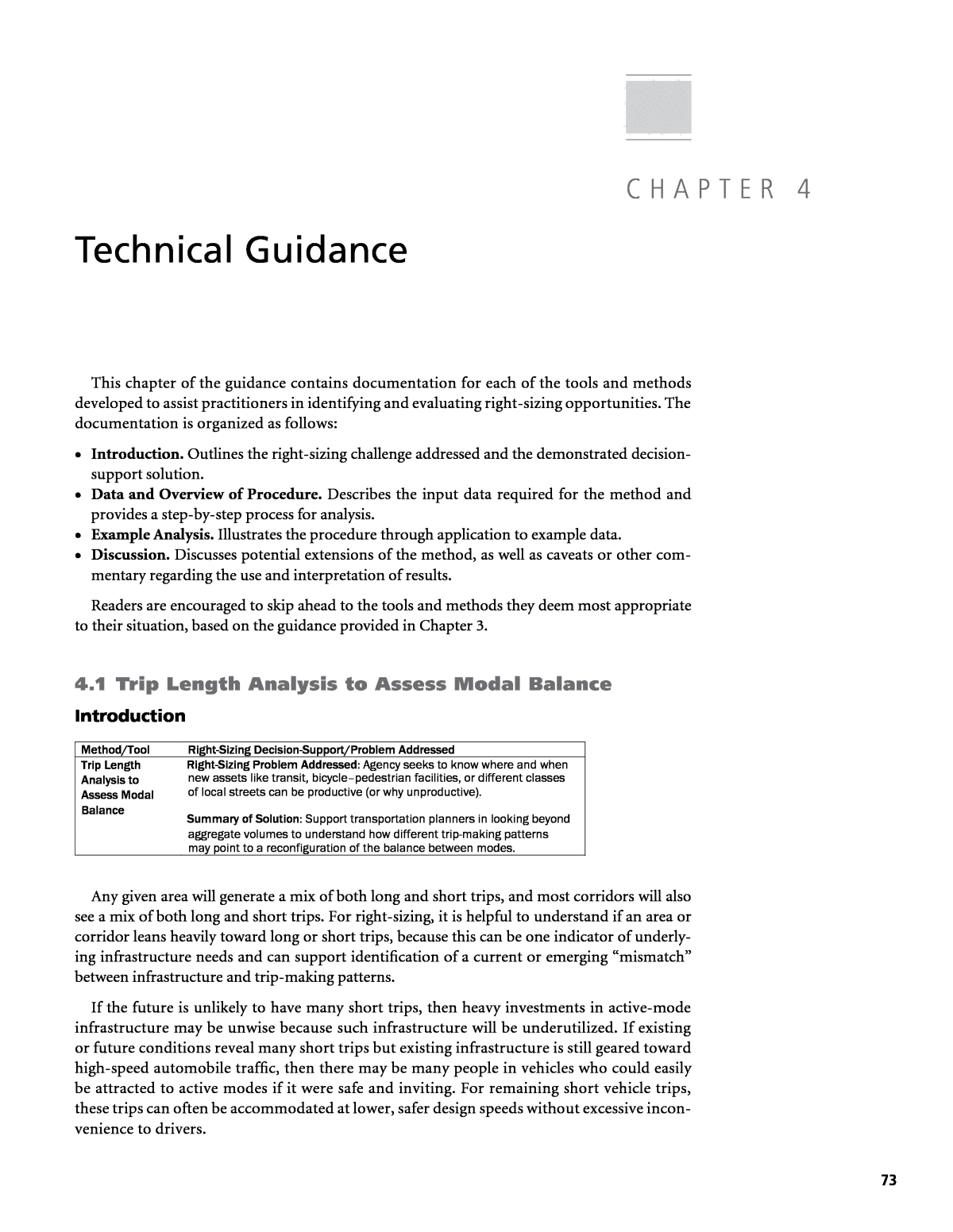
74 Right-Sizing Transportation Investments: A Guidebook for Planning and Programming Land uses within districts and along key corridors often change considerably over time. Initial infrastructure attributes may have once been right for the context but, if that context has changed or will soon change, then it would be poor practice to perpetuate the status quo. Trip length analysis is one approach for discovering such places. Typi- cal situations in which this method is most relevant involve corridors and districts that in the past were very low density and had considerable separation between residential uses and commercial uses but now have (or will soon have) higher densities and a stronger mix of uses. The basic premise is illustrated in Figure 6. The top of the figure shows how the corridor may have been in the 1970s, with a âbedroom communityâ dominated by homes on the left and a large district of jobs on the right. In such cases, the majority of vehicles on the corri- dor would have to travel the entire length of the corridor for any work or shopping-related activity. Now suppose that the same corridor by 2015 has diversified considerably and average densities have measur- ably increased. Traffic counters may still measure 30,000 vehicles at any point on the road, implying erroneously that nothing has changed. A closer look, how- ever, would reveal that where there used to be 30,000 unique vehicles averaging 5-mile trips on the corridor, densities have more than doubled and there are now 60,000 unique vehicles, but each vehicle averaging just over 2 miles on the corridor, resulting in the same VMT on the corridor. Thus, the corridor of the 1970s may have served the community well with a 45 mph speed limit, no bike facilities, and very limited pedestrian features, because the great majority of users were on long-distance vehicle trips where high speeds were desirable. However, there may now be significant latent demand for alternative modes that could materialize if the corridor were reinvented for the emerging context. The next section explains two methods for analyzing emergent contexts to identify where trips are relatively long and therefore more likely to appreciate high-speed private or public motorized transport, or relatively short and therefore more likely to benefit from a focus on making active mode transport safe and inviting, perhaps at the relative expense of longer motorized trips. The two methods are limited data method and travel demand model method. Defining Long Versus Short Trips ⢠Long: Above 10 miles Auto or transit, higher speeds desirable ⢠Medium: 5â10 miles Auto or transit, higher speeds less essential ⢠Short: 1â5 miles Strong demand for motorized and non-motorized modes ⢠Walkable: 0â1 miles Auto-based trips are circulatory, parking-anchored Figure 6. Illustration of same average annual daily traffic but changing trip lengths and user needs.
Technical Guidance 75 Data and Overview of Procedure Best Practice Right-Sizing Actions for Short-Trip, at-Grade Corridors The Institute of Transportation Engineers and Congress for the New Urbanism have together published guidelines for designing walkable urban thoroughfares. A few best practice recommendations from that guidance for corridors that have or soon will experience a shift toward shorter trip lengths follow from the Institute of Transportation Engineers and Congress for the New Urbanism (2010): ⢠Ten-foot travel lanes, 35 mph maximum speed limit. ⢠Barrier separation between traffic and bike/pedestrians (can include well-utilized on-street parking). ⢠Uniform street trees within parking lane or within park strip. ⢠Park strip/pedestrian buffer of 5â10 feet rather than the more typical historic 0â4 feet. ⢠Off-street cycle track where possible. Trip Length Analysis, Limited Data If assessing a single arterial corridor and you have limited data, this process will help deter- mine whether the corridor likely leans toward long trips or short trips that could be attracted to active modes. Attributes of corridors that skew toward long trips and are unlikely to change much are 1. Many corridor segments of a third of a mile or longer where land uses within 1,000 feet of the corridor are dominated by single-family homes. 2. Significant numbers of single-family homes abut the corridor, but they are generally well kept and of higher value, and thus unlikely to see pressure for conversion to mixed uses that would result in a diversification of trip types and lengths. 3. Plans do not call for mixed uses or indicate any significant likelihood of additional commer- cial at key intersections. 4. Existing bike and pedestrian activity is very low. Bike and pedestrian crashes are below average. Indicators of short trips, or trends toward short trips, and therefore a priority for complete street investments and active mode safety enhancement are 1. Within 1,000 feet of the corridor, there are considerable multi-family units frequently adja- cent to general commercial. ⢠Limited data approach: Description of the type of current and anticipated future development within 1,000 feet of the corridor Descriptive information on level of bike and pedestrian activity Bike and pedestrian crash data, relative to an average for comparable facilities ⢠Regional travel demand model approach: Table of zone-to-zone trips Table of zone-to-zone network mileage Needed Input Elements
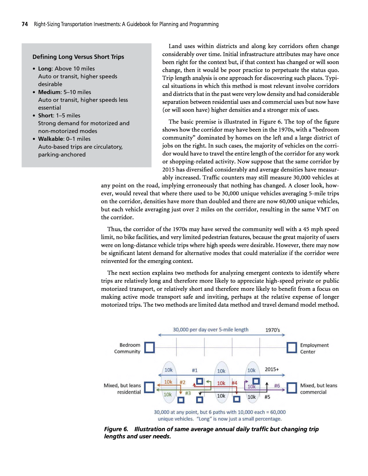
76 Right-Sizing Transportation Investments: A Guidebook for Planning and Programming 2. Communities regard the corridor as economically blighted and/or are actively promoting more multi-family and mixed uses. In such cases, trips may not yet be particularly short, but there is reason to believe they soon will be, and right-sizing decisions toward that end can help communities achieve land use goals. This indicator points to right-sizing in anticipation of higher densities and a stronger mix of uses. 3. Communities are adopting form-based codes, and developers are actively seeking to aggre- gate under-utilized parcels to create townhomes and larger projects. 4. Existing bike and pedestrian activity is relatively high. Bike and pedestrian crashes are above average. Trip Length Analysis, Regional Travel Demand Model Where a travel demand model is easily accessible, trip-length analysis can be undertaken more formally on a zone-district or corridor basis. Zone-based analysis will identify broad areas where complete street investments will prove more valuable. To conduct the analysis, follow these general steps: 1. Determine person miles traveled (PMT) between each traffic analysis zone by multiplying the total person trips between each zone by the number of miles between each zone. 2. Sum PMT from each zone to all other zones and divide by the sum of trips to calculate average trip length. 3. Interpret results as an indicator of right-sizing potential. These steps are illustrated by an example in more detail that follows. Consider the illustration of the four districts or cities shown in Figure 7 (each district made of multiple travel analysis zones). Suppose that, in the 1970s, most districts were either heavily commercial or heavily residential. By 2015, average annual daily traffic (AADT) has grown somewhat, but total person trips have grown even more, from 3,000 to 6,000 trips per day. Land uses are far more mixed than they were before, resulting in far higher percentage of intra-district trips than occurred in the past. Computing Person Trip Miles. Table 22 depicts this situation numerically and graphically (resembling a figure), using hypothetical data that are easily available from most travel demand models. The top tables show the total number of person trips produced by each district and Figure 7. Illustration of changing uses in four districts.
Technical Guidance 77 attracted to other districts. Notice that in the 1970s, intra-district trips (the diagonal) are rela- tively low compared with 2015, because in the 1970s it was harder for a trip to stay in the same district due to monolithic land uses. The middle tables show total road network miles between each district, which does not change over time. PMT is then simply the number of trips mul- tiplied by the distance between each district. Notice at the bottom that while the total number of person trips has increased 100% from 3,000 to 6,000, PMT has only increased by 38%. This implies average trip length has gone down. Notice each table has a row-sum area and column- sum area, both of which are used in the next step. Computing Average Trip Length. In modeling parlance, there are two types of trips: pro- ductions and attractions. Attracted trips are trips attracted by commercial areas from residential areas. Produced trips are the opposite: trips produced by residential areas that are attracted to commercial areas. Most districts have both jobs and housing. If there is more housing, then production trip length will be longer than attraction trip length because residents of the district must go further to get to the average job, while the typical job in the district will have plenty of residents nearby. However, if there are more jobs, then attractions will have a longer length because the area will import workers and shoppers from further away, while any residents in these commercial districts will have ample jobs nearby. 1970's Total Person Trips 2015 Total Person Trips District 1 2 3 4 Tot A District 1 2 3 4 1500 800 300 400 3000 2000 1650 850 1500 6000 1 280 100 100 50 30 1 1000 700 200 50 50 2 570 300 200 50 20 2 1250 300 800 100 50 3 1050 600 300 100 50 3 1400 400 400 500 100 4 1100 500 200 100 300 0.27 4 2350 600 250 200 1300 1.24 Tot P 3000 Internal vs External 0.75 6000 Internal vs External 0.87 Miles Between Districts Miles Between Districts 1 2 3 4 1 2 3 4 36 29 32 53 36 29 32 53 1 36 2 5 9 20 1 36 2 5 9 20 2 29 5 1 6 17 2 29 5 1 6 17 3 32 9 6 3 14 3 32 9 6 3 14 4 53 20 17 14 2 4 53 20 17 14 2 Person-Miles Traveled Between Districts (PMT) Person-Miles Traveled Between Districts (PMT) 1 2 3 4 1 2 3 4 17100 5900 2450 2240 27,690 18500 8450 5350 5850 38,150 1 1,750 200 500 450 600 1 3,850 1400 1000 450 1000 38% 2 2,340 1500 200 300 340 2 3,750 1500 800 600 850 3 8,200 5400 1800 300 700 3 8,900 3600 2400 1500 1400 4 15,400 10000 3400 1400 600 4 21,650 12000 4250 2800 2600 27,690 38,150 1970 Person Trips 3000 1970 PMT (1000s) 28 2015 Person Trips 6000 2015 PMT (1000s) 38 Pct Change 100% Pct Change 38% Attractions Pr od uc tio ns Attractions Pr od uc tio ns In te rn al vs Ex te rn al In te rn al vs Ex te rn al Table 22. Person trips, miles, and person miles traveled.
78 Right-Sizing Transportation Investments: A Guidebook for Planning and Programming Thus, it is possible to compute the average trip length for productions separately from attrac- tions and then add them together to determine the average of both productions and attractions. Table 23 shows how this is done. First, compute production trip lengths: miles per trips is com- puted as the ârow sumâ of all PMT from Table 22, divided by the row sum of the total trips. The result is miles per trip for each production in the district. To compute attraction trip lengths, list the column sum of PMT next to the column sum of total trips and divide to get miles per trip for attraction trips. To determine the average of both productions and attractions, simply add the PMT of both productions and attractions, then add the total production and attraction trips, and then divide to determine the average miles per trip, regardless of whether it is a production or attraction trip. In this example, even though person trips have increased by 100%, average trip length has been reduced by 33%. This means that the typical corridor in the area will have seen annual daily traffic grow considerably since 1970 but less than double even though person trips have doubled. Interpreting Results in the Context of Right-Sizing. Now consider the average trip lengths for District 1 (yellow cells in Table 23). In 1970, the average was 11 miles, while now the average is closer to 7 miles. While 7 miles is still farther than most people will walk or bike, a bell-curve distribution of those trips will reveal significantly more trips in the 0â2 mile range than existed in the past, perhaps enough to warrant complete street investment. If actual counts of walk- ing and biking in District 1 are low, this may be somewhat deceptive, as this could be caused by dangerous or unattractive conditions more than a lack of eligible short trips. This method Dist. Person-Trip Miles (3) Total Trips (1) Miles per Trip Dist. Person-Trip Miles (3) Total Trips (1) Miles per Trip Pct Change 1 1,750 280 6 1 3,850 1,000 4 -33% 2 2,340 570 4 2 3,750 1,250 3 -25% 3 8,200 1,050 8 3 8,900 1,400 6 -25% 4 15,400 1,100 14 4 21,650 2,350 9 -36% 27,690 3,000 9 38,150 6,000 6 -33% Dist. Person-Trip Miles (3) Total Trips (1) Miles per Trip Dist. Person-Trip Miles (3) Total Trips (1) Miles per Trip Pct Change 1 17,100 1,500 11 1 18,500 2,000 9 -18% 2 5,900 800 7 2 8,450 1,650 5 -29% 3 2,450 300 8 3 5,350 850 6 -25% 4 2,240 400 6 4 5,850 1,500 4 -33% 27,690 3,000 9 38,150 6,000 6 -33% Dist. Person-Trip Miles (3) Total Trips (1) Miles per Trip Dist. Person-Trip Miles (3) Total Trips (1) Miles per Trip Pct Change 1 18,850 1,780 11 1 22,350 3,000 7 -36% 2 8,240 1,370 6 2 12,200 2,900 4 -33% 3 10,650 1,350 8 3 14,250 2,250 6 -25% 4 17,640 1,500 12 4 27,500 3,850 7 -42% 55,380 6,000 9 76,300 12,000 6 -33% P+A Average P+A Average Conditions in 1970's Conditions in 2015 Productions (Use Row-Sum) Productions (Use Row-Sum) Attractions (Use Col-Sum)Attractions (Use Col-Sum) Table 23. Trip lengths for productions versus attractions and by district.
Technical Guidance 79 suggests that despite low counts, there may be considerable latent demand to travel by active modes if such travel can be made safe and enticing. Furthermore, for trips that remain in vehi- cles, the average vehicle trip has shifted more toward intra-district circulation and less toward long-distance commuting. For short circulation trips, drivers are less bothered by low speeds, so it is reasonable to consider traffic-calming design and lowering the speed limit to improve the alternative mode experience. Another interesting observation is the difference in trip length for productions versus attrac- tions. Consider the green cells for District 4 (see Table 23). In the past, District 4 was a collection of homes and not really a city at all. Trips produced by residents of District 4 were virtually all attracted to jobs and services in other districts. Now District 4 has become a much more inde- pendent city with grocery stores and many population-attendant jobs and services. Residents are still attracted to the larger city frequently, but much less so. That is reflected in the drop of production trip lengths from 14 to just 9 miles (productions = people going from home to jobs and services). Attraction trip lengths in 1970 were just 6 miles (attractions = people coming to jobs and services). This value is much shorter than 14 because few people come from the larger city to the smaller one, so attraction-based trips tend to be residents of District 4 going to their local gas station or visiting friends, and so forth. But by 2015, this 6 miles has been reduced to just 4 miles, which suggests an increasing share of residents are staying in District 4 more often than in the past now that there are more and more services. Example Analysis Using a regional travel demand model, Salt Lake City previously followed the process just described to generate a trip length diagram for Salt Lake County, Utah, shown in Figure 8 (analysis Figure 8. Trip length analysis for Salt Lake County, Utah.
80 Right-Sizing Transportation Investments: A Guidebook for Planning and Programming by Metro Analytics on behalf of Salt Lake City). Notice locations dominated by short trips tend to be near the historic CBD. Industrial and commercial areas tend to be blue, meaning they have few residents nearby and tend to import workers and shoppers from far away. Extreme residential areas tend to be blue or dark green. These usually have a few retail services such as gas stations and grocery stores but almost no industrial or office jobs, so many residents of those areas commute long distances. Such a map can be helpful in identifying locations where active-mode investments are likely to be heavily utilized. In this example, Salt Lake City wanted to know if it made sense to convert 300 West (the area outlined in bold red) into a complete street. A trip length comparison shows that trips generated within the area are short relative to the rest of the county. There is considerable under-utilized land in the area, and a market analysis suggested a complete street there would likely attract more than 1,000 households and another 1,000 jobs into the corridor that would have other- wise gone elsewhere. The city estimated based on local knowledge and judgment that the redis- tributed development would tend to come from the area within the black boundary. Using the process noted earlier, average trip length for 300 West was determined to be 5.5 miles, while the average trip length within the black border was 7.5 miles. A benefitâcost analysis then determined that developing 1,000 residential units and 1,000 jobs in an area with 5.5-mile trip lengths would significantly reduce VMT relative to the same devel- opment in a 7.5-mile area. The analysis also determined that while the complete street would slow traffic, which has a negative economic benefit, slower also means safer and more attractive to alternative modes, which would produce a positive benefit that exceeds any negative benefit. Beyond just this one quantitative measure, there are also equity benefits to more types of users than drivers and quality-of-life benefits. Table 24 shows the overall positive benefitâcost ratio for this example, which occurs largely by relocating future development into a shorter trip-length area where it can benefit from complete street conditions. This application of a benefitâcost evaluation also relates to the trade-offs between safety and travel time that are further illustrated in the development-sensitive safety analysis in Section 4.3. Discussion Time series or cross-sectional analysis. Trip-length analysis can be used both to compare past trip lengths to present or likely future trip lengths and to compare across a geography in Expected Accidents in the 40th Year 40-Year Benefit Summary Based on Initial $15m Cost Type Discount Rate Safety Benefit Total Benefit Benefit / Cost Ratio Benefit of reduced VMT Cost of slower travel No Build Build Reduction Property Damage Injuries 144 127 Fatalities Not Claimed -43% -48% 82 66 N/AN/A 3% 7% $29 $11 $107 $47 $89 $33 7.2 3.1 -$47 -$25 Table 24. Benefitâcost analysis: relocating future development into a shorter trip-length area.
Technical Guidance 81 The process is easiest within a spatial information system that can handle multiple data sets, such as a GIS. While this is not the only tool, it is the most widely used tool and will be a reference for the remainder of the procedure: 1. Obtain a base linear referencing system (LRS). This road network should have a unique seg- ment identification that can be used to link tabular information to it. The data can then dynamically segment the LRS by milepost. the same time, as in the Salt Lake City case. For example, due to lack of data, it may be chal- lenging to determine how trip lengths in an area have changed over time. It might be simpler to determine what they actually are now or are likely to be in the future and to prioritize complete street and active mode investments toward existing or emerging hot spots for short trips. Big Data Analytics. Emerging data sources are making it increasingly possible to assess trip-making patterns based on observed activity as recorded by devices such as cell phones or in-vehicle GPS units (e.g., see State Smart Transportation Initiative at https://www.ssti.us/wp/ wp-content/uploads/2017/07/SSTI_Connecting_Sacramento_Tripmaking.pdf). The data sources provide another resource beyond travel models for exploring current conditions. An angle of future exploration might determine how to utilize these data sources to discern latent demand for non-motorized short trips that are made in vehicles, primarily because alternative mode infrastructure is unavailable or unattractive. 4.2 Roadway Utilization/Cost Screening Introduction Method/Tool Right-Sizing Decision-Support/Problem Addressed cycle and preservation costs are going to low-utilization, potentially redundant facilities. outliers in the road network that impose disproportionately high life cycle costs for the level of traffic (or other metrics of utilization) that they serve. Roadway Utilization/Cost Screening Right-Sizing Problem Addressed: Agency needs to understand where life Summary of Solution: Systematic screening procedure for identifying This screening process simply classifies roadway facilities based on the accumulated life cycle cost in relation to historic and/or projected utilization. Its purpose is to identify areas or single pavement segments where the life cycle cost per trip (LCT) is highest. These locations are poten- tial candidates for right-sizing opportunities either needing modified construction practices, alternative uses, jurisdictional transfer, or some other right-sizing strategy to mediate the poten- tial imbalance in the system from over investment. As a screening method, this process can provide relatively easy diagnostics of potential overbuild in the roadway network. Extensions of this method can look beyond volume to other metrics of utilization to understand the network supported by ongoing transportation network investments. Data and Overview of Procedure ⢠A consistent road network that is either segmented in the same lengths as the tabular data or that the tabular data can be dynamically segmented upon ⢠Current traffic volumes for the roads ⢠Maintenance records associated with the road segments Needed Input Elements
82 Right-Sizing Transportation Investments: A Guidebook for Planning and Programming 2. Secure the following data sets in a form that can be linked to the road network, either as static tables, or more ideally as links to the relevant databases (i.e., through a SQL) that can be updated seamlessly in the future for real-time analysis: â Current traffic volumeâAADT. â Maintenance and repair records that contain quantified values for labor and material costs. Alternately, records could be paired with another table to be monetized. This is usually found in a maintenance management system or a similar information system. â Records of capital improvement projects. 3. Per the roadway segments, calculate the maintenance repairs and capital improvements done for the roadways during a certain timeframe. This analysis may be done in longer blocks of time to accumulate multiple actions per segment. For example, a road may receive a crack seal treatment or be resurfaced every 4 to 5 years, but the road is milled and overlaid every 12 to 15 years. A 10-year horizon may not capture the total repair picture. As a default, it is recommended to look at 20 to 25 years to match the design life of a roadway. 4. Join the summarized maintenance and capital improvement data with the roadway volumes. Calculate the LCT as = ΣLCT Life-Cycle Costs ($) Current Traffic Volume where life-cycle costs include maintenance and capital improvements. 5. View the outputs in either tabular format or spatially on a map. Single out the highest values of LCT as candidates for potential right-size decision making. The thresholds will vary by area according to the inputs previously outlined, because the LCT values are relative accord- ing to the geographic area. It is therefore recommended to take the top 10% of segments as candidates and/or those segments that fall into the top two quintiles. Example Analysis As an example of this methodology, Figure 9 shows a network of arterials. Traditionally, for pavement the preservation investment deci- sion is based on the pavement condition score (present serviceability rating, IRI, or related measure). The figure shows the network and the pavement condition reflected in a scale where red is bad, green is average, and blue is good. Note the three segments that are labeled. Of the three segments, the traditional criterion offers a clear choice of preservation priori- ties. Segment A is in poor condition, Segment B is in fair condition, and Segment C is in excellent condition. A classic pavement manage- ment methodology would target the very poor (red) and poor (yellow) segments for improvement and then prioritize them according to a costâbenefit equation (based on agency or agency plus vehicle operat- ing costs). Thus, among these three segments, Segment A would be the most likely target for investment. Looking at the network according to the individual inputs for the Roadway Utilization/Cost Screening, as shown in Figure 10, the user can see where high daily traffic occurs and where historical maintenance and capital improvements (combined and normalized per mile) were focused. Both maps continue to use the red/green/blue scaling to reflect where traffic and cost, respectively, are highest (shown in red). Screening for Candidate Projects Objective: identify segments and locations where there is a potential imbalance between resources and markets served. Next Steps: agency staff can evaluate right-sizing opportunities, such as modified construction practices, alternative uses, jurisdictional transfer, or some other right-sizing strategy.
Technical Guidance 83 The screening method combines these two variables into an equation, which was identified previously as LCT. As shown in Figure 11, application of the method (with the given LCT for- mula) illustrates the outcome of this effort and labels Segments A, B, and C again for compari- son. These three segments all perform poorly according to the equation, because the costs per daily vehicle for these segments are above $20 per vehicle. This is well above the network average of $1.95 per vehicle (keeping in mind that these values are specific to this example geography and do not reflect standards for other areas or a national average). Combining the LCT results (Figure 11) with the results from the classic pavement management process shown in Figure 9 Figure 9. Pavement conditions.
84 Right-Sizing Transportation Investments: A Guidebook for Planning and Programming Figure 10. Comparative traffic volumes and historic preservation outlays. reveals that while Segment A has poorer pavement condition than Segments B and C, Seg- ment A also has a high LCT. Therefore, the segment warrants special attention before making a preservation outlay to determine if either through a design, materials, or another decision, its ongoing preservation cost can be reduced (to bring it more in line with the demand served) or if its investment priority may be lower than other segments with poor pavement conditions (but revealed to represent efficient investments in the final analysis). When brought into programmatic review of all the poor condition segments shown in Fig- ure 9, the LCT screen reveals Segment A as the most likely candidate for a right-sizing strategy. An agency might consider reduced preservation standard or other remedies to reduce preser- vation cost. The screening also suggests a review of outlays for Segments B and C to consider potential right-sizing remedies before their next preservation expenditure.
Technical Guidance 85 Note that there are nuances to interpreting the data results: Segment C is in the highest quantile of the LCT screening. It does have low volumes and an above-average maintenance cost allocation. However, the pavement condition is excellent. This could potentially mean an improvement was just completed, resulting in the spike on cost. While the LCT calculation is correct, this candidate might be dropped from the list because no right-sizing action is necessary. This segment should be flagged for reference in future years to make sure it does not repeat- edly appear as a candidate. Repeatedly being screened as a candidate would be an indicator that Figure 11. Right-sizing candidates revealed by the screening.
86 Right-Sizing Transportation Investments: A Guidebook for Planning and Programming right-sizing strategies may be beneficial. Segment B has high volume and cost totals (Figure 10), as well as a fair pavement condition (Figure 9). The LCT calculation accounts for this high cost on high traffic roads as this would be a normal expectation of the roadway wearing down with use. Nevertheless, the screening allows for comparison with other high-volume roadways in the network. This would identify (as it has) a segment like Segment B that may have higher than expected LCT ratios, thus making it a potential candidate for a right-sizing strategy, such as modified construction practices to reduce the frequency of treatment actions on this segment. Discussion The screening process is easy to implement and to adapt to current asset management and programming processes. The screening process can be modified to screen based on other indica- tors of need beyond volume. The Roadway Utilization/Cost Screening illustrates potential inef- ficiencies in funding spent per a network segment. Spatially, the denominator in the equation could change to any network attribute (i.e., lane miles) or network type (sidewalk network or transit system). The identification of inefficiencies remains constant and is simply a screening to identify the opportunity for a different solution, such as rightsizing the network, or its compo- nents because the roadway system is over-engineered for the traffic it carries, resulting in high maintenance costs and a high LCT. Potential modifications to the LCT calculations according to agency specific needs include to ⢠Expand the volume denominator to include additional modes (i.e., bicycle) or to count pas- senger rather than vehicular trips to place additional benefit to higher-occupancy cars and transit. ⢠Focus on indicators of specific affected user groups that are of known strategic importance, such as volumes of truck traffic, commodity value, or measures of specific commodity flows. ⢠Relate the network costs to area-based measures of the market served. This could include population or employment counts or specific indicators such as measures of agricultural production. This approach can elaborate on spatial equities across regions and districts, rural versus urban areas, and environmental justice issues. Note that the appropriate screening metrics may vary by area type. Whereas in urban areas, networks may be more oriented toward serving people (as counted through trips or population metrics), rural area networks may be intended to serve agricultural or other forms of resource- based production that are better reflected in goods-oriented measures. The screening is also versatile in the network considered and whether it is applied to historic and/or projected utilization. The screening can be used statewide or regionally, on all roads or by functional class, and could even be stratified by funding source (federal-aid eligible roads versus state-owned/nonâfederal-aid eligible roads). The screening could also be used with forecasted data through a travel demand model for traffic and pavement management system for the costs, along with planned capital improvement costs (if not captured elsewhere). This could highlight future inefficiencies and actually predict right-sizing candidates long before an investment date or programming cycle is reached. This method is ideal for use in a TAMP as required under the MAP-21 and FAST Act (see 23 U.S.C. 101(a)(2), MAP-21 § 1103, https:// www.fhwa.dot.gov/map21/docs/title23usc.pdf). Finally, within the screening methodology described, the user may wish to account for roads that have already been right-sized in future screenings. The user can do this by simply comparing the screened list of roads to a working list of roadways that have been right-sized (however right- sizing is defined within a broader program), thus removing those roads previously right-sized
Technical Guidance 87 from the candidate list. A user would do this to avoid counting past maintenance totals against the roadways prior to the roadways being right-sized. For example, if Segment A had recently been improved through a right-sizing action yet the repair costs prior to the right-sizing were still being totaled in the screening process, the user would need to manually realize this fact and remove Segment A because of this recent change to the roadway characteristics. Alternatively, the user could work some definition logic into the scripting that tabulates the maintenance on a segment based on a pre-identified date. This date could be different for every segment, which means that once a roadway is rebuilt or right-sized in 2015, for example, no action prior to 2015 would be calculated in the screening total. This would remove the effort to keep a separate list and avoid any variances in the results. 4.3 Development-Sensitive Safety Analysis Introduction Method/Tool Right-Sizing Decision Support/Problem Addressed investments that compromise travel speed to accommodate a changing development context become beneficial. account the comparative benefits of increased land use density, complete streets features, and urban transportation amenities, as well as travel time, reliability, and crash costs or savings. Development- Sensitive Safety Analysis Right-Sizing Problem Addressed: Agencies need to understand when Summary of Solution: Apply a costâbenefit analysis that takes into This methodology is designed to help an agency rightsize corridors or other facilities in situ- ations where the development context surrounding a facility is changing the potential sources of value generated by that facility. It is implemented, along with an example analysis, within the accompanying Excel workbook DevelopmentSensitiveSafetyAnalysis. The method allows the user to account for differences in trip lengths and volumes associated with a new develop- ment pattern that may be enabled by complete streets amenities. The method also enables users to account for anticipated crash reductions (by selecting crash rate modification factors from suggested sources) in comparison with likely speed changes associated with a different corridor design. Data and Overview of Procedure ⢠Characteristics include the projectâs first year of operations, the first year that the land use change is expected to occur (enabled by the right-sized street design), and an estimated growth rate of background traffic. Characteristics also include the incremental annual rate at which the land use change is expected to occur (in terms of the percentage of the full build-out that is expected to occur in each year, starting with the first year of the change). ⢠(undiscounted) for the project and no-build scenario. ⢠traffic levels, the current acreage of build-out, and the percentage of acres on which density is expected to change during the project life. Also, assumptions regarding the type (residential versus commercial) and scale (square footage, number of dwelling units, and number of jobs) of new development in the build versus no-build scenarios. ⢠5 years) by severity level (property damage, injury levels, and fatalities) and crash modification factors associated with changes in speed and specific changes in roadway characteristics, by which the analyst will derive best versus worst case post- build crash rates. Needed Input Elements Project Characteristics. Cost Streams. Planned public expenditures for each year of the analysis period Development Assumptions. Information about the size of the project area, existing Crash Assumptions. Crash history for the corridor or network affected (recommended
88 Right-Sizing Transportation Investments: A Guidebook for Planning and Programming Elements for Specifying a Development-Sensitive Safety Scenario. In the Excel workbook provided, the first four tabs (colored red) represent input assumptions about the corridor or sub-area to be analyzed. Within each of these tabs, the cells shown in beige indicate specific values that the user must enter to define the right-sizing scenario. Elements Showing Results of the Analysis. The fifth tab (the BCA tab) is in gold and pres- ents the findings of the analysis, including the present value of costs or savings to users associated with the change in relation to the present value of benefits. The sixth through ninth tabs are green and show intermediate calculations associated with the scenario. These are available to enable the practitioner to trace the intermediate calculations of benefits. The sixth tab shows travel characteristics associated with the project characteristics, development assumptions, and crash assumptions provided in the scenario. The seventh tab shows the benefit streams resulting from the application of the fixed factors and discount rates, and the eighth tab shows how the benefit streams are collapsed into comparative agency and user costs (and savings) between the right-sizing case and the base-case (yielding the summary of benefits). Cells shaded in blue represent intermediate calculations and cells shaded in yellow represent simple applications or transformations of the user inputs. The ninth tab includes fixed factors (or factors for monetizing travel characteristics), which should be periodically checked as U.S. DOT or other agencies issue updated guidance for the most current values (see, for example, https://www.transportation.gov/sites/dot.gov/files/docs/mission/office-policy/ transportation-policy/284031/benefit-cost-analysis-guidance-2018_0.pdf). Elements Only Relevant for the Example Application. At the back of the workbook are four tabs in blue that are not intended for user input but that document some of the source data used in the application example that follows. The final tab in purple represents data in the example that follows as it was received from the Utah DOT. Step 1: Define Project Characteristics The first step in development-sensitive safety analysis (supported by the first tab on the work- book) entails defining the overall parameters for the area or system to be considered in the improvement. The parameters include the following. They are the first year that the facility will operate with the right-sized features, an assumption regarding the background traffic growth rate (independent of whether the improvement occurs); the first year in which the changes in land use associated with the right-sizing are expected to occur; and the annual rate at which the incremental development (the development associated with the right-sizing change) is expected to occur. The first year the facility will operate will be understood throughout the analysis as the beginning of the planning horizon. It is important to note that the faster the assumed rate of incremental development, the sooner the need (and potential benefit) for the right-sizing improvement will be found. For example, if the beginning year of land use change is presumed to be 2025 and the annual phase in percent- age is 100%, the assumption is that in the year 2025, 100% of the land use change will occur, and there will be no further change after that. By contrast, if the assumption is that the first year is 2056 (near the end of the planning horizon) and the annual phase-in percentage is 5%, then it is unlikely that 100% of the potential land use change will even occur before the end of the planning horizon. A critical aspect of creating a right-sizing scenario of this type is developing assumptions about how much change in land use there can be (in Step 3) and the timing and rate of the change in the right-sizing scenario. Step 2: Define Base Versus Build Case Cost Streams In the second step (facilitated by the second tab of the workbook), the user should enter the outlays that the affected agency (or agencies) expect to make for the right-sizing solution
Technical Guidance 89 in comparison with the base-case outlays that would be made without the solution. These outlays should be entered in undiscounted constant dollars. (For more guidance on typical cost categories to include and other guidance on standard BCA practices, review https://www. transportation.gov/sites/dot.gov/files/docs/mission/office-policy/transportation-policy/284031/ benefit-cost-analysis-guidance-2018_0.pdf.) The tool will apply the discounting. Step 3: Define Land Use Development Scenario Defining the land use scenarios (facilitated in the third tab of the workbook: Development Assumptions) is critical to assessing a right-sizing safety improvement. In this step, the user defines how the land use characteristics of the area immediately served by the project will differ between the right-sizing scenario and what would occur without the right-sizing change (or its associated land use changes). This comparison is to be presented in terms of the anticipated land use conditions by the final year of the analysis horizon (in this case, 36 years from the first year of operation as determined in Step 1). Development scenario may reflect increased or decreased density. When considering a land use scenario, note that the scenario can reflect densification (additional build-out) or dis- persion (declining development or density). The tool can be applied in a scenario in which density is declining, to consider when and whether a new facility design allowing for increased speed and trip length should be considered. The tool can also be applied in an area of increasing density, to analyze reductions in speed from associated infrastructure changes. No âchicken versus eggâ assumption. The âchicken versus the eggâ assumption is a philo- sophical debate regarding how land use change relates to infrastructure design. Some methods require an assumption about development, which then leads to an assumption about infra- structure needs. Other methods presume an infrastructure scenario will create a market for new development. This tool is agnostic on the question of causality and simply compares a land use scenario in which the facility is right-sized versus one in which the scenario is not. The rationale for what makes the scenario occur (or what makes the scenario likely) is a debate that takes place outside of the tool (but that may be informed by the toolâs findings). The âright-sizing scenarioâ simply represents a scenario in which there is land use change paired with an infrastructure investment to accommodate that change. This is compared with a base case in which neither the land use nor transportation changes are in place. The tool can be used to mix and match differ- ent assumptions about the relative amount of land use change and the relative intricacy of the infrastructure investment by simply making changes in the development and crash assumptions, as well as the relative costs of the infrastructure changes considered. Overall development scenario assumptions. The first set of inputs includes the length of the corridor (or the number of linear miles of roadway on the network subject to the right- sizing), the underlying traffic level expected, and the acreage of land adjacent to the potentially right-sized area. These assumptions are the same, regardless of whether the right-sizing scenario occurs. However, key development characteristics that will likely differ between a right-sizing scenario and a âbusiness as usualâ base case include the percentage of the adjacent acres expected to densify, the floor-area-ratio currently on the sensitive acres, and the additional floor-area-ratio that may be gained or lost, depending on whether the right-sizing scenario occurs. The nature of new development (occurring with increased density). The transportation performance effects of new development (and key economic considerations such as the value of time and other factors) depend very much on the nature of the new or changed land use develop- ment characterizing a right-sizing scenario. The tool requires an assumption about the percent- age of the affected development that will be residential versus commercial. This assumption is to be provided as a characteristic of the scenario to be tested and hence must be developed as part of the planning process outside of the tool. As there is more commercial development there will
90 Right-Sizing Transportation Investments: A Guidebook for Planning and Programming be more commuting (and potentially delivery) traffic and may have more economic effects than residential. Based on these percentages, the tool estimates how many incremental residential and commercial square feet of development are likely to change in the area served, in the project no build and build scenario. Based on this square footage, the spreadsheet then estimates how many dwelling units or jobs will likely occupy those square feet. Suggested values of 700 square feet per dwelling unit and 350 square feet per job are offered in the example, but these may differ depending on context and can be customized. Local land use planners and developers should be helpful in defining these assumptions. Once assumptions are made about the nature of affected development, the tool will estimate the changes in trips based in the study area as a function of the type of development. Changes in travel characteristics. The next step considers how the change in development pattern will affect trip lengths. In this part of the analysis, the practitioner considers the charac- teristics of those trips displaced by the land use change in the study area (shown by the tool in Rows 49â51 of the Development Assumptions tab). If (1) a trip once based outside of the study area is attracted to now be based in the study area or (2) a trip once based in the study area is now based in a different type of area, the practitioner must consider how the nature of the trip is likely to change. Will the trip be longer or shorter? Is it more likely to use alternative modes? Could there be a difference in auto occupancy? Will the percentage of truck trips change? The practitioner must also make assumptions about the prevailing speeds under each development assumption and what percentage of the traffic will be subject to congestion. Caution about over-modeling travel characteristics It is not necessary to predict these changes with precision or to get lost in an overly intricate modeling exercise. The objective of this part of the analysis is simply to describe the general nature of differences between the current state and the potential future state of the study area. The objective is not to eliminate uncertainty but rather to manage uncertainty by testing out iterations of âwhat ifâ scenarios to see how solid the potential right-sizing benefit could be. Iteratively testing and determining that a right-sizing approach will be beneficial under a wide range of development assumptions (and understanding the assumptions that would have to hold for a change to offer right-sizing benefits) will prove more productive and empowering than getting bogged down in modeling efforts that seek to be â100% accurateâ in anticipating characteristics. Sources of development scenario transportation assumptions To start testing development assumptions, if a travel model or other private data sources are available, the practitioner can identify an area with similar density and land use characteristics today as the study area may have envisioned build-out to arrive at a travel profile including trip lengths, modal shares, speeds and percentage of VMT subject to congestion. Private data sources can include StreetLight, AirSage, or other âBig Dataâ sources (to learn more about trip making with big data, refer to the State Smart Transportation Initiative website at https://www.ssti.us/wp/wp-content/uploads/2017/07/SSTI_Connecting_Sacramento_Tripmaking.pdf). Public sources can also be used to arrive at such a profile. For example, the Census Longitudinal Origin-Destination Employment Statistics (also known as LODES) tables can be used to build block-to-block worker flow matrices and summarize key modal and trip length characteristics. A state or MPO could also conduct selected special counts and speed studies at locations matched to the right-sizing candidate area by development density, traffic level, and distance from major surrounding downtowns or other major traffic generators.
Technical Guidance 91 Step 4: Define Safety Characteristics and Anticipated Crash Modification Factors The final set of inputs needed by users addresses the safety performance of the corridor or network studied (shown on the fourth tab of the workbook titled Crash Assumptions). The workbook shows a 7-year crash history of crashes by severity (shown in Cells A5âF12). This type of information can be obtained from a state DOT, department of public safety, or in some cases a local police department. The tool will use this information to compute existing/historical crash rates occurring today (prior to the potential right-sizing change). The practitioner must consider which aspects of the right-sizing change could affect crash rates. Changes in speed will affect fatalities, injuries, and property damage (even in the absence of any other changes). Crash rates may also be affected by other design changes such as whether on-street parking is permitted, whether there is access density or access management (driveways), and the absence or presence of medians or bike lanes. Crash modification factors (CMFs) can be specified in Cells A32âA38 of the Crash Assumptions tab. The spreadsheet is set up to allow for a âbest caseâ and âworst caseâ CMF in order to enable further sensitivity testing. The methodology as implemented also reduces the effectiveness of each individual design change, allowing for the fact that crash reduction effects are typically not completely additive. Caution about over-modeling travel safety As with trip characteristics, the objective with crash modification factors is not to predict with certainty crash outcomes. Instead, the objective is to make a reasonable comparison between the observed safety performance of todayâs facility and the incremental change in crash propensity associated with the right- sizing features (which the tool then contextualizes relative to changes in other scenario trip characteristics such as speed, volume, trip length and others). Practitioners should not understand the tool as a predictive tool but rather as a sensitivity testing tool that enables users to test crash modification factors to consider how effective each safety countermeasure included in the right-sizing scenario would have to be to achieve right-sizing benefits, given the other assumptions made and the current observed performance. The inherent uncertainty of right-sizing requires acceptance that the practitioner will not have a ârightâ answer regarding future performance but may be able to evaluate the merits of a right-sizing proposal based on the likelihood that a particular assumption can hold given (1) the amount of change it would require from the status quo and (2) whether the assumption holds in other areas matching the envisioned future of the right-sizing candidate. Sources of development scenario crash assumptions Because crashes are well reported and well studied, there are a number of sources for selecting crash modification factors for right-sizing safety analysis. Practitioners are referred to NCHRP Report 617: Accident Modification Factors for Traffic Engineering and ITS Improvements (Harkey et al. 2008), NCHRP Research Report 841: Development of Crash Modification Factors for Uncontrolled Pedestrian Crossing Treatments (Zegeer et al. 2017), and the forthcoming research from NCHRP Project 17-72 (http://apps.trb.org/ cmsfeed/TRBNetProjectDisplay.asp?ProjectID=3875) and NCHRP Project 17-76 (http://apps.trb.org/cmsfeed/ TRBNetProjectDisplay.asp?ProjectID=4052) for specific guidance in this area. There are also online sources, including an FHWA Clearinghouse of Crash Modification Factors (see http://www.cmfclearinghouse.org/). The FHWA Clearinghouse has reviews by engineers from throughout the world on the consistency with empirical outcomes and best practices. These sources can affect the type of modification factors, as well as the values, the practitioner may select to use in Cells A32âE38 of the right-sizing safety workbook.
92 Right-Sizing Transportation Investments: A Guidebook for Planning and Programming Step 5: Interpret Reports and Compare Benefits Once a right-sizing scenario is completely defined (in Steps 1â4), the practitioner can look to the BCA summary on the sixth page of the workbook to consider the benefits (or disbenefits) associated with the combination of development assumptions and right-sizing actions. In the example shown, the report enables the user to see the expected cumulative losses in travel time and reliability associated with the speed reductions (due to safety treatments and increasing densities) in relation to the potential changes in crash costs (which are generally lower when speeds are reduced, and designs can better accommodate more complex travel envi- ronments). Also reported are changes in emissions and vehicle operating costs (which may be increased by slower speeds but reduced by shorter trips). The BCA summary report enables the user to see how the combination of factors associated with the right-sizing scenario create the benefit and also indicate whether the scenario would have positive or negative net benefits, and the expected benefitâcost ratio. Iterative Use of the Tool The tool is for iterative sensitivity testing. For example, the user may note the findings in the BCA summary from an initial analysis and then go back and test different CMFs to determine what minimum safety performance benefit would be needed for a right-sizing option to be ben- eficial (holding other assumptions constant). In a similar way, the user may establish a fixed set of assumptions about travel characteristics and associated CMFs for different levels of develop- ment and then determine what the magnitude and rate of build-out for land use changes would have to be in order for the right-sizing change to be worthwhile. There is not a single right way to use the tool. Rather, the tool empowers practitioners to engage in the right-sizing discussion to both formulate and evaluate the business case for ele- ments of a right-sizing solution, and under what circumstances it can be justified on the grounds of improved safety and safety-related characteristics. It should also be noted that while this methodology is designed around safety in changing travel environmentsâeven if safety is held constant and there are not CMFs at allâthe method can still be used to evaluate changes in density, speed, and modal characteristics as well. Example Analysis As an example of this methodology, an analysis of the 300 West corridor in Salt Lake City, Utah, is considered. The corridor currently has proximity to Downtown Salt Lake City and is considered ripe for redevelopment. However, its current design characteristics are seen as so dated and misaligned with the best and highest use of land and other infrastructure in the area as to be an impediment to economic growth. Existing problems include ⢠Underutilized seven-lane segments. ⢠Extra-wide lanes and underutilized parking encourage speeds in excess of 45 mph. ⢠Sidewalks that exist abut the curb and have power poles, hydrants, and so forth blocking them. ⢠High pedestrian crossings at unsafe locations. ⢠Stark hardscape impedes efficient development. ⢠Excessive driveways and dangerous, uncontrolled left turns. ⢠High cost of failing pavements and utilities. Blocked Sidewalks Too Fast Worn Out Current outdated/design characteristics of 300 West Corridor.
Technical Guidance 93 ⢠No acceptable bike facilities in corridor with latent bike demand. ⢠Eleven out of 12 bus stops are not ADA compliant. There are approximately 200 acres adjacent to 300 West, about half of which are significantly underutilized as reported by local economic and real estate organizations. If rebuilt as a com- plete street, experience elsewhere in the city and across the country suggests 300 West is likely to attract at least 1,000 new residents and 1,000 new jobs that otherwise would have occurred in locations with higher trip lengths and lower walk/bike/transit shares. The City of Salt Lake has proposed a right-sizing solution to (a) align the facility with both the best and highest use of the street itself, (b) enable significantly better and higher uses of surrounding land, and (c) induce a more efficient regional devel- opment and trip pattern. Project highlights include ⢠Sections with seven lanes reduced to five lanes, ⢠Lane width reductions, ⢠New, buffered sidewalks, ⢠Mid-block pedestrian crossings, ⢠Underutilized parking removed, ⢠Protected bikeways installed, ⢠Trees and improved aesthetics, ⢠Upgrade of 11 of 12 non-ADA compliant bus stops, ⢠Fiber optics and utility upgrades, and ⢠Rejuvenate failed pavements. While all parties involved understand the misalignment on the corridor, part- ners also recognize that changes in the design of the street could potentially reduce traffic speeds, the costs of the enhanced infrastructure could be significant, and design changes may or may not improve safety conditions as envisioned. There are questions about how realistic or aggressive the underlying assumptions of the right-sizing scenario are. The development-sensitive safety analysis provides a mechanism for identifying, articulating, and testing the specific assumptions and circumstances under which the investment can be justified. Use of the tool offers a business case related to the investment and elevates the dialogue from simple recognition of the misalignment to a discussion about specific improvement features, what they cost, and the plausibility of envisioned changes in terms of development pattern, safety, and travel characteristics. Step 1: Define Project Characteristics For the 300 West Corridor, the project is envisioned to begin in 2021, generating benefits through a horizon year of 2057. The underlying compound annual growth rate expected in traffic is 0.2% (according to the MPO travel model). Furthermore, it is anticipated by the city and local development community that after the new facility begins to operate, the changes in land use may not begin to occur until 5 years later (given the time it takes to plan and begin implementing development) and will occur at a rate of 3.5% until the right-sized development pattern is fully built-out. Table 25 shows how these characteristics are represented in the first tab of the Excel workbook. Step 2: Define Base Versus Build Case Cost Streams The city determines the cost streams for the investment in terms of the anticipated out- lays both with and without the project. The project forgoes operational and maintenance Wheelchair user on 300 West Corridor using non-ADA compliant ramp.
94 Right-Sizing Transportation Investments: A Guidebook for Planning and Programming improvements in 2017â2019, instead fully replacing the misaligned infrastructure in 2020 and 2021, putting the entire facility on a different maintenance cycle thereafter. Once the new facil- ity is in place, ongoing operations and maintenance costs will tend to be lower, with most of the additional agency outlays for implementing the right-sizing occurring in 2020 and 2021. Table 26 shows the undiscounted values for the first 13 years of the cycle to demonstrate this pattern. Within the tool workbook, these values are discounted at 3% and 7% for further use in the analysis. The difference between the scenarios drives the net cost used in the analysis (the far right columns). Step 3: Define Land Use Development Scenario Many of the assumptions about the land use characteristics are derived from a comparison of land use and transportation characteristics of the 300 West study area (shown in the bold red polygon in Figure 12) and the significant area to the south of the study area, currently exchang- ing trips with the central business district (shown in the red circle). A comparison of trip lengths, speeds, and travel times from the Wasatch Front Regional Council (MPO) travel demand model proved an appropriate source of information for many of the assumptions used in this case. Additional land use characteristics are also implicit in the nature of the study area itself (such as the amount of available land, square footage, and occupancy). Figure 13 provided by the Salt Lake City Corporation shows significant detail on the parcels surrounding the project and is First Year of Operation 2021 % Compound Annual Growth Rate in Overall Traffic 0.20% Beginning Year of Land Use Change 2026 % of Annual Incremental Phasing in of Densified Development 3.50% Project Characteristics Table 25. Example project characteristics. Project Year Calendar Year Capital Costs ($2017) O&M Costs ($2017) Capital Costs ($2017) O&M Costs ($2017) Capital Costs ($2017) O&M Costs ($2017) 0 2017 116,067 0 0 -116,067 1 2018 116,067 0 0 -116,067 2 2019 206,472 0 0 -206,472 3 2020 0 1,000,000 0 1,000,000 0 4 2021 0 14,000,000 0 14,000,000 0 5 2022 23,213 0 0 -23,213 6 2023 46,427 0 0 -46,427 7 2024 69,640 0 0 -69,640 8 2025 92,853 0 0 -92,853 9 2026 116,067 15,581 0 -100,486 10 2027 235,968 31,162 0 -204,806 11 2028 0 46,743 0 46,743 12 2029 0 89,091 0 89,091 13 2030 23,213 0 0 -23,213 BUILD PROPOSED PROJECT CASE 2017 Dollars (Undiscounted) BUILD Minus BASE 2017 Dollars (Undiscounted) BASELINE - NO PROJECT CASE NO BUILD 2017 Dollars (Undiscounted) Table 26. Example cost streams.
Figure 12. Development of land use characteristics through regional comparisons. Legend RDA Project areas TRAX Light Rail Stop Homeless Resource Center (HRC) 1300 S Bicycle Bypass (waiting on approval) Figure 13. Study area details.
96 Right-Sizing Transportation Investments: A Guidebook for Planning and Programming complemented by parcel-level data available from the city about historical and potential uti- lization. Consideration of the development capacity as shown in the figure, validated through discussions with real estate brokers and comparison with other developing areas in the city, provides a basis for reasonable assumptions about the anticipated development pattern. Table 27 shows the key development characteristics used in the tool to describe this scenario. The corridor is 2.1 miles long and has underlying volume (AADT) of 17,000 and 200 acres of adjacent land potentially served by the project. Both the city and real estate officials interviewed indicate 30% of these acres are likely to densify regardless of whether the project occurs, but the densifying acreage is estimated as 50% if the project is completed. The floor area ratio for those areas that densify are generally understood as likely to increase from .15 to .30 under the 50% densification scenario by consensus of municipal and development partners. The new development is estimated to be 70% residential and 30% commercial and to be developed with 700 square feet per dwelling unit and 350 square feet per job. Finally, the available travel demand model indicates likely trips associated with this land use to be seven per dwelling unit and eight per job. The total number of household and non-household-based trips affected by the potential right- sizing are thereby calculated by the tool as 6,403 and 6,273, respectively (as shown in Table 28). A comparison of travel characteristics regarding mode-choice, trip length, and truck utilization (between where the trips are currently based and where they will be based in the right-sizing scenario) shows that the affected trips are assumed to be 0.1% more likely to be on a non-auto Both No Build Build 2.1 17000 200 30% 50% 0.15 0.15 0.15 0.3 Residential Commercial 70% 30% Both No Build Build 392 1,307 336 1,120 DUs Jobs 915 784 7 8 Person-trips per day per unit (jobs tend to be retail and food, which attract more trips per job than other jobs). Likely Source: Travel Demand model Incremental jobs (assume 350 SF / Job) Incremental residential dwelling units (DUs) (assume 700 SF / DU) Measures of New Activity Concentrated in Study Area Due to Land Use Change Increase over no build Development Scenario Assumptions Project Area Characteristics Nature of New Development (occurring due to increased density) Share of new SF that would be residential / non-residential, respectively Project Area Characteristics Existing floor area ratio (to avoid double counting when replacing old with new) Additional floor area ratio of new development within the study area, above todayâs base (calculations based on this increment) Base AADT on the corridor, both build and no build Total acres directly adjacent to changing area Percent of acres where land use is expected to densify Corridor length, miles Table 27. Key development characteristics.
Technical Guidance 97 mode, have an average length of 5.54 miles compared with 7.46 miles, and that truck utilization is expected to be unaffected by the change. Further comparisons show that trips in locations matching the anticipated future land use profile already have lower speeds (37 to 42 miles per hour) than in areas from which the new development is attracted in the scenario (speeds of 40 to 45 miles per hour), and that these speeds would be further reduced to 36 miles per hour by the increased density and design fea- tures of the right-sizing scenario. The design features include narrower lanes, reduced number of lanes, increased crossings, and so forth. Because truck traffic is not expected to be displaced (as shown in the previous table), it is assumed truck speeds will be unaffected. The scenario defini- tion also assumes that the 65% of hours spent in congested conditions in the build case will be less than the 75% of hours spent in their current location under the base case. Finally, the scenario assumes that 5% of the displaced trips may change their modal character- istics from auto mode to a non-auto mode due to the walkability characteristics of the right-sized corridor. This assumption was seen as reasonable given the 0.1% difference in existing non-auto share between the two areas (as shown in the second table of this section) and the number of amenities included in the right-sizing package. Table 29 shows this assumption and summarizes how the tool represents the culmination of the other assumptions/scenario characteristics, in terms of a vehicle trip summary that may be expected by the horizon year of the analysis. Household Based Trips Non-Household Based Trips 6,403.32 6,273 Increased person-trips over base-year (Note: Trips in corridor, but would have been in suburban location otherwise) 12,676 Total person-trips above no-build (DU+Job based trips) Existing Locations New Location 0.9 0.8 Pct of trips by car, had development occurred at suburban location, versus pct by car at Proposed New Location 11,400 10,100 Person-trips by car, if suburban versus if Proposed New Location 1.39 1.39 Auto occupancy factor, both locations (federal guidance) 8200 7300 Vehicle trips 7.46 5.54 Average trip length at each location (Taken from Travel Demand model) 0.03 0.03 Freight Trucks 0.12 0.12 Delivery Trucks on corridor Overall Increases in Trips Based in the Study Area That Would Have Been Based Elsewhere in No Build Differences in Traffic Characteristics Between New Location and Default/Base-Case Location Project Area No Build Project Area Build Default (Sprawl Location) - No Build Project Area Build 42 36 45 36 Starting 85th% speed cruise speed: General Traffic 37 36 40 36 Starting 85th% speed cruise speed: Trucks & Delivery 0.6 0.6 0.6 0.6 Reduction factor to account for signals, congestion, etc. 25.2 21.6 27 21.6 General Traffic average speed, with stop lights & congestion 22.2 21.6 24 21.6 Truck average speed, with stop lights & congestion 0.65 0.65 0.75 0.65 Pct Congested, peak 0.1 0.1 0.1 0.1 Pct Congested, off-peak On-Corridor Trips Displaced Trips Trip Characteristics Between Densified/Urban Area and Default Area Trip Characteristics Table 28. Scenario travel characteristics.
98 Right-Sizing Transportation Investments: A Guidebook for Planning and Programming Step 4: Define Safety Characteristics and Anticipated Crash Modification Factors The Salt Lake case also entailed considering safety characteristics for the scenario. Table 30 summarizes 7 years of past safety performance for the study area (as currently built) using data from a DOT crash database. Using the sources described earlier in this section, the Salt Lake case selects and applies crash modification factors for each feature of the right-sizing scenario (Table 31). The column to the right indicates the sources for the selected CMFs. Furthermore, because in some cases there is a range of CMFs that may apply, the tool allows for a best-case assumption and a worst-case assumption to be considered, based on the variability in CMFs. In this case, the variability in CMFs was 1.5. The default of the tool is to calculate BCAs based on the worst-case scenario. Step 5: Interpret Reports and Compare Benefits Table 32 gives the summary of benefits for the Salt Lake example. The summary shows that the scenario analyzed yields a positive net present benefit and has a benefitâcost ratio greater than 1. However, more important, the analysis shows that the improvement in safety Project Area No Build Project Area Build Default (Sprawl Location) - No Build Project Area Build N/A 0.95 2.1 2.1 7.46 5.54 17,000 16,250 8,200 7,300 14,450 13,700 6,970 6,200 510 510 250 220 2,040 2,040 980 880 On-Corridor Trips Displaced Trips Pct of trips by car, had development occurred at suburban location, vs pct by car at 300 West Complete Street (assume 5% converts to walking, biking, transit) Number of freight trips Number of delivery trips Vehicle Trip Summary, Horizon Year Trip Characteristics Summary Average trip length at each location (Taken from WFRC model). Used for VMT below. For on- corridor, only count on-corridor part of trip. Off corridor count entire trip, since the differential is relevant. Number of vehicle trips Number of car trips Table 29. Vehicle trip summary. Background Annual VMT 35,700 0.04 Million VMT Severity Property Damage Minor Injuries Significant Injuries Serious Injuries Fatalities (None) 2010 27 18 7 1 0 2011 24 7 16 2 0 2012 34 14 12 3 0 2013 35 9 5 2 0 2014 23 14 12 0 0 2015 29 14 14 0 0 2016 48 18 22 3 0 7-Yr Ave 31.4 13.4 12.6 1.6 0.00 Note: There were no fatalities in 7 years, but it is reasonable to assume no build would average 1 every 10 years. Total Base Year/Background Crashes in Study Area Table 30. Crash history.
Technical Guidance 99 Best Case/Worst Case Reduction Factor = 1.5 Best-case Best-case Worst-case Worst-case CMF Reduced* CMF Low Reduced* 15% reduction in speed, effect on fatalities 0.9 0.9 0.93 0.93 Elvik, R., Chris tensen, P., and Amundsen, A., Speed and Road Accidents: An Evaluation of the Power Model . Os lo, Norway, Transportokonomisk Institutt, (2004) 15% reduction in speed, effect on injuries 0.9 0.9 0.93 0.93 Elvik, R., Chris tensen, P., and Amundsen, A., Speed and Road Accidents: An Evaluation of the Power Model . Os lo, Norway, Transportokonomisk Institutt, (2004) 15% reduction in speed, property damage 0.9 0.9 0.93 0.93 Elvik, R., Chris tensen, P., and Amundsen, A., Speed and Road Accidents: An Evaluation of the Power Model . Os lo, Norway, Transportokonomisk Institutt, (2004) Remove on-street parking 0.9 0.97 0.78 0.93 Highway Safety Manual (2010) Raised Median 0.9 0.97 0.78 0.93 Reduce driveways 0.9 0.97 0.75 0.92 Elvik, R. and Vaa, T., Handbook of Road Safety Measures (2004) Protected/buffered Bike Lanes 0.9 1.00 0.95 1.00 Chen et a l ., Evaluating the Safety Effects of Bicycle Lanes in New York Ci ty, June (2012) *Italic assumes each feature is not 100% additive (relative to a project with just one CMF), so benefit is reduced accordingly. Note: New bike lanes also have their own CMF, but assume benefits already shown more than account for any added benefit of bike lanes. All CMFs come from CMF clearinghouse, and are 4-star rated or higher. Crash Modification Factors for Project Area Project items that will result in better safety Table 31. Crash modification factors for project improvements. Benefit 3% discount rate (in $millions) 7% discount rate (in $millions) Undiscounted (in $millions) Vehicle Operating Costs $27.4 $10.6 $62.3 Business (Freight) Time and Reliability Costs -$24.4 -$12.8 -$44.7 Value of Personal Time and Reliability -$3.7 -$4.6 $1.6 Safety $70.2 $30.7 $147.9 Environmental: Non-CO2 -$0.2 -$0.1 -$0.3 Total Benefits $69.3 $23.7 $166.8 Costs 3% discount rate (in $millions) 7% discount rate (in $millions) Undiscounted (in $millions) Capital Investment Costs $13.4 $11.5 $15.0 Operation and Maintenance Costs -$1.0 -$0.8 -$1.3 Total Costs $12.3 $10.7 $13.7 3% discount rate (in $millions) 7% discount rate (in $millions) Undiscounted (in $millions) Net Present Value $57.0 $13.0 $153.1 3% discount rate (in $millions) 7% discount rate (in $millions) Undiscounted (in $millions) Benefit/Cost Ratio 5.62 2.21 12.17 Benefit Cost Summary Table 32. Analysis results.
100 Right-Sizing Transportation Investments: A Guidebook for Planning and Programming (attributable to slower speeds and right-sizing features) and reduction in vehicle operating costs (associated with shorter trips and more efficient operations in the right-sized area) are sufficient to offset the significantly higher travel times and potential reliability costs of a denser and slower facility. Discussion While this understanding of scenario benefits is helpful, the intended use of the tool is to pres- ent these benefits alongside the scenario characteristics. For example, the narrative should be âto achieve the envisioned $13 million net benefit stream (at 7% discount rate), the right-sizing scenario would have to (1) cost no more than $10.7 million (discounted at 7%); (2) increase density on 20% of the acres in the study area, 70% of which would have to be residential, and all of which would have to occur between 2026 and 2056; and (3) enable the newly built density to make trips that are nearly 2 miles shorter while still traveling at a speed of 36 mph on the corridor and reduce crashes to about 73% of what they are today.â The ensuing dialogue supported by the tool is envisioned to include developers, engineers, planners, and other right-sizing partners and to address the following types of questions: ⢠Who has the $10 million and would find such an outcome worth such an investment (or $13.7 million if undiscounted)? ⢠Are these conditions achievable and, if so, how? ⢠What can the right-sizing partners do to make them achievable? ⢠If the parties do not agree with this scenario, what aspects are questionable? What other assumptions or scenarios are worth testing? Through iterative application of this tool, it is expected that right-sizing partners can arrive at more than just a vision (of the type that might arise from a corridor study). Instead, the tool can help facilitate identification of roles and specific performance targets (in terms of land use, safety, traffic management, and infrastructure) that justify and may be used to trigger the right- sizing actions. 4.4 Stratified Return on Investment Calculator Introduction Method/Tool Right-Sizing Decision-Support/Problem Addressed assessing how well a right-sizing solution meets diverse criteria about the efficient mix of components or level of investment in infrastructure features. Summary of Solution: Provide a consistent decision-support framework for considering differential return on investment from the perspective of multiple entities involved in a potential right-sizing scenario. Stratified ROI Calculator Right-Sizing Problem Addressed: Right-sizing partners have difficulty The ROI Calculator facilitates comparison of the costs and benefits of right-sizing projects to promote discussion among the partners involved. The user specifies the right-sizing projects, the potential partners, the criteria that represent success to each partner, and the projectsâ effects on each criterion. The ROI Calculator identifies the project scenarios that best achieve partnersâ goals and describes the distribution of costs and benefits across the project scenarios. This can inform discussion and decision making by the partners and identify opportunities to modify the project to meet partnersâ goals. Two macro-enabled Excel-based versions of the calculator are provided. The first version, âRight-sizing ROI Calculatorâ is empty, while the second version, âRight-sizing ROI Calculator_ Example Dataâ is populated with example information.
Technical Guidance 101 Tool Purpose Each right-sizing project is unique, both in its physical attributes and in its institutional and political framework. Because the need to rightsize is almost by definition unplanned, potential partners in a right-sizing project need a starting point for negotiation. The ROI Calculator is intended to provide foundational analysis to facilitate discussion and consensus seeking. The calculator informs leaders and decision makers of state DOTs, MPOs, city and county govern- ments (e.g., mayors, city councils, county executives, and county commissions), universities, non-profits, other major land holders, and other major stakeholders. It also informs planning and engineer staff, who lay the groundwork for discussions among organizational leaders. The ROI Calculator is suitable for early and intermediate project phases. The ROI Calculator can be used early in the planning process to explore possibilities for cooperation and to identify project scenarios that achieve partnersâ goals. The calculator can also serve intermediate phases to build a foundation for moving from broad discussions to commitments and decisions. The ROI Calculator places right-sizing projects within the context of partnersâ responsibility to the greater transportation system through the selection of criteria, which should reflect their overall missions. Because the calculator accommodates these real-life goals, its results account for the larger systems that influence agencies. Tool Applications The ROI Calculator can serve a full range of right-sizing project types and scenarios. These include projects encompassing transfer of ownership or management of a segment of the trans- portation network to align the level of ownership or management with the level of use. The transfer may involve nearly any set of agencies. An illustrative example involves asset transfer from a state DOT to a local government. Transfer of the asset may be desirable if the primary purpose of the segment has changed significantly since its construction, for instance if local traf- fic and non-automotive modes have displaced through traffic. Rightsizing the stateâs network by relinquishing responsibility to a local government can increase responsiveness to local needs and better align the geographic scope of funding with the scope of use. Universities or other campus-based institutions whose plans entail the partial pedestrianization of local roads some- times encounter a similar transfer from local to institutional management. The ROI Calculator can also accommodate physically reshaping the portion of the right-of- way dedicated to different uses (e.g., automotive traffic, transit, bicyclists, or pedestrians). The calculator helps reveal how a project benefits the users of the right-of-way and if the scale and distribution of those benefits justify project costs. Data and Overview of Procedure ⢠⢠⢠Units of measurement (the tool will suggest defaults if desired). The predicted values for criteria under each scenario. These values should be estimated outside the ROI calculator based on planning factors, engineering judgment, or computerized aids like traffic models, travel demand models, and land use models. Thresholds delineating âexcellentâ and âpoorâ results for each criterion. The user defines the thresholds for each criterion that represent an excellent or a poor result. Alternatively, the calculator can auto- populate them based on the maximum and minimum criteria values across project scenarios. Importance of each criterion. Criteria are weighted on a four-point scale of importance from âsomewhat importantâ to âextremely important.â Needed Input Elements Scenario definitions may be useful to summarize the problem motivating right-sizing and right-sizing objectives. For record keeping, descriptions of each scenario can also be saved in the tool. Partners are organizations involved in the right-sizing project and the amount (or percentage) each partner will contribute to the right-sizing project under each scenario. Criteria that signify success for each partner. The tool provides example criteria from which to select. In addition, for each criterion the user will input:
102 Right-Sizing Transportation Investments: A Guidebook for Planning and Programming The ROI Calculator is contained entirely within an Excel workbook. The calculator consists of five data-input steps and a final step that provides results. 1. Step 1 asks the user to define the project scenarios under consideration. 2. Step 2 asks the user to designate up to four potential right-sizing partners and their likely financial contribution to each project scenario. Step 2 also includes a tool to help the user estimate each partnerâs likely financial contribution and a tool for estimating life-cycle costs. 3. Step 3 asks the user to select criteria that signify success to the partners. A dropdown list allows the user to choose from predefined criteria. Units for criteria selected from the drop- down list may be auto-populated. Users can also manually enter criteria and units. 4. In Step 4, the user inserts an estimate of each criterionâs value in each scenario. These pre- dicted values are computed outside the ROI Calculator. The user also specifies definitions of poor and excellent for each criterion. Alternatively, these can be auto-populated by the calculator based on maximum and minimum criteria values across project scenarios. 5. In Step 5, the user specifies the importance of each criterion by rating it on a four-point scale from somewhat important to extremely important. 6. Step 6 provides the results, summarizing benefits and costs by scenario and also showing the performance by criterion for each scenario. Implementation Guidance with Example The following subsections provide instructions for inputs in each step of the ROI Calculator and have accompanying images to illustrate the progression through the calculatorâs interface. The process is illustrated with a hypothetical example. Practical Example The figures throughout this section are populated with notional data from a practical example, which is described and interpreted in text boxes located near the figures. The example considers three right-sizing project scenarios that include three partners: a state DOT, a local government, and a developer. The state DOT currently owns and manages a road segment passing through a city. Over time, the state route has become congested with local traffic, and numerous businesses and residences have opened along the route. A developer is considering a major residential and commercial project adjacent to the road segment that is a high priority to the city government. The developer has made full investment contingent on changes to make the road more amenable to local, non-motorized uses. The state DOT is considering whether its mission of safe intrastate and Interstate movement can best be achieved under the current ownership and management configuration, or if it would better serve its mission to transfer or reconfigure the road segment for local uses. In the latter scenarios, most through traffic would be rerouted. The state DOT, local government, and developer have informally discussed their goals and project funding. Home Page The ROI Calculator begins with a home page linking to five data-input steps and a results tab. The home page includes a brief description of each step and a clickable button to bring the user directly to that step (Figure 14). The ROI Calculatorâs interface on the home page and on the
Figure 14. Screenshot of home page.
104 Right-Sizing Transportation Investments: A Guidebook for Planning and Programming following pages emphasizes buttons to navigate within the ROI Calculator and manipulate data (e.g., insert default values or clear previous entries). Each step in the ROI Calculator has a common design format. At the top center is the name of the step in white text on blue background. To the left are buttons to return the user to the home page or to the previous step. To the right is a button that advances to the next step. Cells await- ing input are indicated with light yellow shading. The ROI Calculatorâs core design elements are visible in Figure 15. Some steps use a tabbed format to access data inputs for scenarios and/or partners. Blue tabs correspond with scenarios, and green tabs correspond with partners. Step 1: Define Project Scenarios In Step 1, the user defines the scenarios. The only required information is the scenariosâ names, which auto-populate later steps. Other project information may also be entered for record keep- ing. The scenarios can include a status quo âno actionâ scenario as well as alternatives. Up to four scenarios may be compared in the calculator at any time. More scenarios may be analyzed in multiple copies of the calculator. Definitions of the input fields in Step 1 are as follows: ⢠Scenario Name: A descriptive name for each scenario (e.g., transfer to local government). ⢠Project Description [optional]: Scenario characteristics such as timeline, length, internal project numbers, and any other characteristics that are useful for record keeping. ⢠Right-Sizing Information [optional]: In this box, the user may enter information about the right-sizing problem and objective or any additional right-sizing information that is common to all the project scenarios. Figure 15 shows a screenshot of the tab for Step 1, populated with user input for the hypo- thetical example. Step 2: Identify Partners In Step 2, the user specifies the partners in the right-sizing project and each partnerâs financial contribution under each scenario. Users can enter up to four partners. As shown in Figure 16, the user input fields are as follows: ⢠Name: Names of the partner organizations involved in the right-sizing project. ⢠Total financial contribution: This measures the financial contribution of the partners to the right-sizing project for each scenario. It may include capital expenses only or it may also include maintenance and other recurring costs. All future costs should be converted to present value before being summed to generate the partnersâ total financial contributions The user may not know specific funding contributions early in the planning process. There- fore, the ROI Calculator includes a tool that can be accessed by clicking on the button labeled âTool for Estimating Partner Costsâ to help the user estimate each partnerâs likely financial contribution. The Tool for Estimating Partner Costs is shown in Figure 17. The user can experi- ment with different cost allocations by entering the total project capital costs for each scenario and the percentage contribution for each partner under each scenario. The tool automatically calculates each partnerâs contribution to the scenario. When the user has produced a satisfac- tory cost allocation, clicking on the âPopulate to Step 2â button for the corresponding scenario populates the partnersâ financial contributions in Step 2. Clicking on the âGo Backâ button in the upper left of the tool returns the user to Step 2. The user can also access the âTool for Estimating Life Cycle Costsâ by clicking on the button with these words. Figure 18 shows a screenshot of the life-cycle cost tool. This tool allows the user to enter costs incurred and revenues earned over the projectâs life span and discounts these costs to present value. Costs and revenues can be entered for any year over a user-defined time period of up to 30 years, in the rows labeled âNominal Costâ and âNominal Revenueâ included for each partner under each scenario tab.
Figure 15. Screenshot of Step 1.
Figure 16. Screenshot of Step 2.
Figure 17. Screenshot of Step 2B.
Figure 18. Screenshot of Step 2C.
Technical Guidance 109 For projects with similar life spans, the net present value allows for accurate comparison of each partnerâs monetary costs under each project scenario. The net present value of monetary costs for each partner under each scenario may be transferred to the âtotal financial contributionâ cells in Step 2 by clicking the button labeled âLink Results to Step 2.â Sometimes the projects being compared have different life spans, which prevent net present values from being directly comparable. For projects with significantly different life spans, it is better to compare the equivalent annual annuity, which converts the net present value to an equivalent annual payment that can be made over the project life span. The scenario with the lowest equivalent annual annuity corresponds to the project scenario that would have the lowest cost if life spans were the same. In other words, the project with the lowest equivalent annual annuity is cheapest, accounting for project life span. The user designates the life span by entering the project scenariosâ start and end years. The start year is the first year in which costs are incurred. Costs may be incurred before the design year (first year of operation), as well as in operational years. The end year refers to the end of the projectâs expected life span. The end year may differ among project scenarios. Practical Example The partners are considering three scenarios. The first scenario would transfer ownership and road management to the local government, which would enhance the pedestrian, bicycle, and transit infrastructure along the route. In the second scenario, the state DOT would retain ownership and management responsibility, but the city would still contribute $2 million to infrastructure upgrades. The state DOT would heavily consider local traffic needs while still facilitating through traffic. The third scenario is status quo. The only spending under the third scenario is for existing maintenance obligations to be borne by the state DOT. The tool for estimating life-cycle costs shown in Figure 18 may be used to convert the costs that would be incurred over multiple future years to a net present value for each project scenario and each organization. In this tool, the costs and revenues associated with the DOT, city government, and developer actions are discounted from the year in which they are expected to be incurred to the projectâs start year. Step 3: Select Criteria In Step 3 (Figure 19), the user defines criteria that characterize success for each partner. The criteria will be used to evaluate the specified scenarios. Users enter information in two fields: ⢠Indicator: The user designates the criteria that each partner uses to define success of the right- sizing initiative. The user can select criteria from a dropdown list or may type new criteria. In some cases, such as collisions, it may be useful to designate the category (e.g., cause of colli- sion) if different categories entail different solutions. Criteria should ideally match partnersâ goals as precisely as possible and distinguish ranges of success. ⢠Units: For each indicator the user also specifies the units of measurement for that criterion. Non-numeric units such as level of service between A and F may be used, in addition to binary variables like a 0/1 indicator for the presence of bike lanes. The âauto-populateâ button can be used to automatically assign units to criteria selected from the dropdown menu. Custom criteria and units should be entered last because the auto-populate button resets the units column.
Figure 19. Screenshot of Step 3.
Technical Guidance 111 Step 4: Enter Criteria Values In Step 4, the user enters estimates of the values for each criterion for each partner under each scenario and also defines thresholds for poor and excellent outcomes for each criterion. Tabs allow the user to switch among partners (Figure 20). Users complete the following fields: ⢠Criteria Values: In the yellow-shaded boxes, users enter estimates of each criterion for each partner under each scenario. Values should be estimated based on analysis outside the ROI Calculator using planning factors, engineering judgment, or computerized aids like traffic models, travel demand models, and land use models. The calculator does not ask the user to specify a future year for which estimates are valid. However, a year that either is shortly after the design year (first year of operations) and is consistent among scenarios should be chosen, and criteria should have attained roughly static equilibrium values. All values should be entered in numeric form, which may require conversion of categorical or binary variables to numbers (such as 1 through 6 for levels of service A through F or 1 and 0 for binary variables). ⢠What is Poor? and What is Excellent? In these columns, the user may manually enter threshold values by typing directly into the corresponding cells. Alternatively, a series of buttons allow the user to auto-populate excellent and poor thresholds by selecting either âLowerâ or âHigherâ in the column labeled âBetter Values Areââ. If the user specifies whether higher or lower values are preferred, the ROI Calculator will automatically com- pare scenarios and apply the maximum and minimum values to define excellent and poor. Practical Example The state DOT defines success around safety and mobility. Therefore, it has selected several criteria relating to traffic speed, perceived safety on a five- point scale, collisions, and conflict points in intersectionsâ design. The city government is approaching the project with the intent of enhancing pedestrian infrastructure, meeting sidewalk requirements related to the Americans with Disabilities Act, and making adjacent properties more attractive to development. The developer is primarily concerned with reducing projected commercial and residential vacancies below a baseline estimate. Practical Example The state DOT predicts that the status quo will produce the highest average speed on the segment and best serve through traffic. However, the status quo scenario performs worst on many of the safety-related criteria because non- motorized traffic will continue to be intermingled with high-speed motorized traffic. The city expects Scenarios 1 and 2 to perform better than the status quo scenario on pedestrian level of service, ADA compliance, and average property values. The developer also anticipates fewer commercial and residential vacancies with Scenarios 1 and 2.
Figure 20. Screenshot of Step 4.
Technical Guidance 113 Step 5: Weight Criteria by Importance Criteria are not equally important to partnersâ perception of success. The ROI Calculator accounts for the differences among criteriaâs importance in estimating the benefit that each scenario provides to partners. As shown in Figure 21, radio buttons allow the user to select the level corresponding with a criterionâs approximate importance to the partner, from somewhat important to extremely important. All criteria are assumed to hold at least some importance to partners. The user can change ratings by selecting a new radio button or clicking the button labeled âClear Importance Ratings,â located on the right side. The ROI Calculator will ignore importance ratings in empty rows. An importance rating must be assigned to each criterion. Practical Example The state DOT rated preventing collisions to be extremely important. Perceived safety and reducing the number of conflict points are rated very important, whereas change in traffic speed is rated important. The city government has assigned the highest importance rating to meeting ADA requirements and lower importance to other criteria. The developer has rated lowering the commercial vacancy rate to be more important than lowering the residential vacancy rate, because its projectâs viability depends most heavily on commercial clients. Step 6: Results The results tab, shown in Figure 22, summarizes ROI Calculator results in several ways. The Summary Benefits table shows the percentage of the importance-weighted criteria for success that each partner obtains under each scenario. A score of 0% indicates that the partner attained none of its goals as defined by the criteria in that scenario, while a score of 100% means that all goals have been achieved. Values between 0% and 100% should be interpreted keeping in mind the influence of two user-designated variables, described as follows. ⢠Thresholds for excellent and poor values: All values above the excellent threshold are considered to have fully met that criterion, whereas all values below the poor threshold have failed to fully meet that criterion. Values between the poor and excellent thresholds are scored based on their relative distance from the thresholds. ⢠Importance weighting: Scores for each criterion are weighted by importance such that more important criteria influence the results more than less important criteria. To the right of the âSummary Benefitsâ table is the âSummary Costsâ table. The Summary Costs table shows the partnersâ expected financial contributions. Projects and benefits cannot be directly compared because benefits have no units while costs are in dollars. Their proximity allows the user to assess whether the achievement of a given percentage of the user-defined ben- efits offsets the monetary cost to the partner. In the summary benefits table, the tool highlights the scenario that achieves the highest aver- age benefit across partners with a green box. Similarly, in the summary costs table, the tool highlights the scenario that achieves the lowest cost with a green box. These may be different scenarios. The box may not automatically reposition when results change. In this case, the user can click the button labeled âHighlight Highest Average Benefitâ to reposition the box to the highest-achieving scenario. Cells in the summary benefits and summary costs tables are also color coded, with the greatest benefits and lowest costs in green, and the opposite outcomes in red.
Figure 21. Screenshot of Step 5.
Figure 22. Screenshot of Step 6 (results).
116 Right-Sizing Transportation Investments: A Guidebook for Planning and Programming Below the summary benefits table is a set of tabs that allow the user to view the achievement of each criterion for each partner under each scenario. The percentages show the extent to which the project scenario achieves the criterion. For example, a score of 50% is halfway between the excellent and poor thresholds. This table can be used to identify the criteria that should be the focus of efforts to increase project benefits by redesigning or reimagining the project scenario. Practical Example Scenario 2 (âretain by state and repurpose ROWâ) generates the highest average benefit. The state DOT achieves 88% of its importance-weighted goals with Scenario 2 versus 66% for the city government and 79% for the developer. By contrast, Scenario 1 (âtransfer to local governmentâ) achieves an average of 67% of the benefits that the partners are seeking, largely because it performs less well on the safety criteria that are very important to the state DOT. Scenario 3 (âno changeâ) achieves only 8% of the benefits sought by the partners since it neither addresses conflicts among modes nor supports the local development sought by the city and the developer. However, Scenario 2 is also the most expensive scenario, costing $10 million versus just $1 million for the status quo scenario. The partners will need to discuss the results to determine if the benefits justify the price and if the costs can be shared in a way that makes the projectâs execution more feasible. If Scenario 2 is deemed too expensive, it may be possible to modify the status quo scenario to address the partnersâ largest concerns at lower cost. Scenario 3 performs most poorly in reducing the number of collisions involving pedestrians and in reducing conflict points. Similarly, ADA compliance is the local governmentâs most important factor, and Scenario 3 performs poorly on ADA compliance. It may be possible to target interventions to improve performance on these criteria at lower costs even if funds are insufficient to address other project aspects. Practical Example The charts help to visualize the distribution of costs and benefits. They show that the state DOT bears the vast majority of the costs of Scenario 2 (âretain by state and repurpose ROW,â marked in gold) even though the scenario achieves substantial benefits for all partners (Figure 24a). Disproportionate distribution of costs and benefits may hinder project execution. The pie charts convey a similar message since the state DOTâs $7 million financial contribution for Scenario 2 (âretain by state and repurpose ROWâ) covers the majority of scenario costs (chart in upper right of Figure 24b). Results are also presented visually. The user may access the table of figures (Figure 23) by clicking on the âSee Chartsâ button in the upper right of the Step 6 tab or by clicking on the Step6_Charts tab at the bottom of the screen. From the table of figures, clicking go next to a chart name moves directly to the respective cluster of charts (Figures 24a and b). Charts show the percentage of achievement of goals by partner and scenario and costs by partner and scenario as bar charts and as pie charts. Charts corresponding with scenarios that have not been run or partners that are not included are empty.
Figure 23. Screenshot of Step 6 (charts).
(a) Figure 24. Results charts: distribution of benefits and costs: (a) bar chart. (continued on next page)
(b) Figure 24. (Continued) Results charts: distribution of benefits and costs: (b) pie chart.
120 Right-Sizing Transportation Investments: A Guidebook for Planning and Programming Discussion Caveats and Limitations Like all tools, the right-sizing ROI Calculator makes assumptions and has limitations that the user should remember when interpreting results. These limitations are summarized as follows. Projects must meet threshold criteria to be appropriate for right-sizing. Not all trans- portation assets will be eligible for all forms of right-sizing. For example, if considering a juris- dictional transfer, users should check the segment of the transportation network against several factors that could impede its ability to be redesigned or transferred. These factors include the following: ⢠The receiving or sending governmentâs ability to absorb liability related to the segment (in the case of transfer from one government to another). ⢠The receiving or sending governmentâs ability to preserve and maintain the infrastructure or service (in the case of transfer from one government to another). ⢠The receiving or sending governmentâs ability to assume financial liability for the infra- structure and/or service (in the case of transfer from one government to another). ⢠The receiving or sending governmentâs legal ability to buy or sell, modify, or abandon a facility. The right-sizing ROI Calculator accommodates a fixed number of scenarios and partners. The right-sizing ROI Calculator can accommodate up to four partner organizations and up to four scenarios. These numbers can be expanded by making multiple copies of the right-sizing ROI Calculator for parallel runs (with some additional post-processing in the case of more than four partners). The right-sizing ROI Calculator evaluates performance at an indefinite time in the future. The use of the infrastructure by the public will necessarily change over time through demo- graphic, economic, and technological trends. Each project scenario reaches a mature equilibrium at a different rate. Nonetheless, the right-sizing ROI Calculator requires the user to provide a single value for each criterion. Therefore, the user should select a future year shortly after the design year at which infrastructure use will be stable, and benefits will have been fully realized. Even though the user can select different years for each scenario, it is strongly recommended to select analogous points in each scenarioâs life cycle for maximum comparability among scenarios. The calculatorâs role changes as a function of the project phase in which it is implemented. Use of the tool in early project phases provides ample opportunity to influence the discussion within and among partners. However, it should also be recognized that partnersâ goals may evolve through subsequent internal discussion. By contrast, the results of analysis conducted with the right-sizing ROI Calculator will be more stable in the intermediate project phase, but there will be less opportunity for the results to shape the discussion. The definition of the best scenario depends on partnersâ goals, engineering constraints, and political feasibilities. The right-sizing ROI Calculator highlights the scenario that on average best achieves the partnersâ definitions of success. This recommendation must be checked against constraints imposed by the administrative and political environment, any engineering or policy constraints, and the distribution of benefits and costs. Those constraints and other important factors are not modeled and should be considered qualitatively or through separate tools. The results should be periodically reassessed if a status quo/no action scenario is initially selected. Many times a decision by partners to take no action will not resolve the problems that raised the prospect of right-sizing in the first place. Moreover, right-sizing may become more attractive over time as trends continue. It is useful to reassess periodically no action decisions by
Technical Guidance 121 rekindling discussion among partners and rerunning the right-sizing ROI Calculator to support their discussions. The reassessment period may be set to align with the partnersâ planning pro- cesses or it may be independent. However, it should occur at a relatively short interval (e.g., 2 to 4 years) if conditions around the road segment are changing quickly or if the tool had previously indicated a viable alternative scenario. The calculatorâs results depend on the quality and comprehensiveness of inputs. The right-sizing ROI Calculatorâs function is to streamline the evaluation of data and knowledge that the user already has or that the user can obtain about the project scenarios under consid- eration. The calculator does not create or verify this foundational data and knowledge. Entry of incomplete information can skew outcomes in multiple ways. A partnerâs right-sizing goals may change, along with the criteria that describe their achievement. It is likewise important that the criteria reflect a broadly based consensus within the organization rather than a given userâs or departmentâs isolated opinions. The userâs predicted values for criteria could also prove to be inaccurate. It is recommended to test predictions for accuracy in multiple ways, such as checking for convergence among forecasting methods or consulting experts about the forecastsâ reasonableness. Although the right-sizing ROI Calculator requires precise estimates of costs and benefits, uncertainty still exists and should be acknowledged. While precise estimates for costs and benefits must be input into the right-sizing ROI Calculator, in reality there may be considerable uncertainty around the costs and benefits scale and the probability of realization of any particu- lar combination of estimates. The user should be careful to use the tool in a way that does not overstate the estimatesâ level of certainty. It is recommended that the user create at least three configurations of costs and benefits before using the tool: an ideal configuration with low (but reasonable) costs and high (but reasonable) benefits, a worst-case configuration with high costs and low benefits, and a best-estimate configuration, featuring moderate values that represent the most likely outcome. These three configurations should be run in the right-sizing ROI Calculator. The best-estimate configuration should feature most heavily in discussion because it is most likely, but the other two configurations should be kept close at hand as a reminder of the range of possible outcomes. Future Research Needs The right-sizing ROI Calculator can be improved based on future research. The current right- sizing ROI Calculator suggests a broad set of criteria that partners may use to define success of the right-sizing project. More research may narrow the list to reduce user burden. An additional advance that will require substantial research and development is to integrate this right-sizing ROI Calculator with a suite of models that are frequently used to generate hypothetical values for criteria corresponding with each scenario, such as traffic models and travel demand models. 4.5 Funding and Development Awareness Method Introduction Method/Tool Right-Sizing Decision-Support/Problem Addressed demands and changing conditions) often control how a projectâs purpose, need, and scope are defined. entities (public and private) with potential incentive to invest in a transportation system or facility, based on improved awareness of surrounding development trends. Funding and Development Awareness Method Right-Sizing Problem Addressed: Available public funds (instead of market Summary of Solution: Identify the full community of potential funding
122 Right-Sizing Transportation Investments: A Guidebook for Planning and Programming The funding and development awareness method is a simple assessment process to provide situational awareness for project planners and designers. The procedure enables an agency to roughly identify (1) the functions served by the existing and possible future transportation infra- structure in an area in relation to (2) the entities that are funding (or that could potentially fund) the infrastructure portfolio at different levels. The method identifies a set of ideas for examining real estate trends or potential redevelopments that might expand the opportunity for use of non- traditional funding sources or create the opportunity for new ones. This method can be applied in right-sizing agreements involving state and local units of government together with develop- ers, major employers, or other governmental entities using resources like county or municipal tax assessor data as well as possible real estate market data. These sources of non-traditional transportation project information are combined with basic roadway inventory information to expand awareness of funding options and allow larger and different projects to be considered by designers when scoping new projects. Projects are often conceptualized with transportation improvement categories, funding sources, and project level goals as pre-determined boundary conditions. Roadway widening or safety projects, for example, usually rely on local, state, or federal funding sources from designated categories. If project designers were aware of real estate market trends or business enterprise considerations around the proposed project, they might be able to modify a design, incorporating additional elements or an improved project design that would not only better meet the community and technical needs but also provide additional funding. Data and Overview of Procedure ⢠City Comprehensive Plan describing vision, goals, growth, and development policies ⢠For the area near the project: Land use plan and zoning map Project goals and funding sources Property value and tax assessments, preferably for past 5 to 10 years Recently issued building permits Development plans for property Needed Input Elements 1. Early in the project scoping and planning stage after the initial purpose and need statements have been prepared, the project team should contact the city or county planners to identify potential development or redevelopment efforts that might be under consideration. This would include the normal project scoping meetings and would also include â A review of the cityâs comprehensive plan and zoning map to determine the likely direction of development in the area. â Recent zoning changes and building permits. â Public engagement findings that might indicate neighborhood support for particular development or redevelopment efforts. 2. All of the normal roadway project data should also be examined to understand the size and shape of the project driversâe.g., congestion levels, pavement or bridge condition, safety, multimodal travel needs, environmental issuesâand how they relate to other societal and economic factors. The goal of this step is to understand how a broader/larger/different project design concept might relate to the background project needs. Figure 25 compares a typical process with a broader right-sized process, and Figure 26 com- pares typical project scoping and broader right-sized scoping. 3. The tax assessorâs database should be analyzed for â Recent change in assessed value near the project to quantify growth/decline trends. â Change in county and/or city values to benchmark project areaâs trends against broader trends.
Technical Guidance 123 â The economic values of new land use types or development intensity to calculate assessed value of land and improvements per square foot. â Calculated changes in land and developed property value over the most recent 5 to 10 years; pay particular attention to developed property that has changed character or intensity. 4. Use the information that follows to begin a discussion with potential partners of right-sizing opportunities. Identifying the right-sized project will be an iterative process that may be as simple as a few steps with different project concepts or could be part of a multi-stakeholder negotiation. For comparison, a regular project examines purpose and need for the project and develops design concepts that meet those requirements. This is typically constrained to a set of inside-the-right- of-way options or consideration of purchasing additional land to implement the project. In redeveloping or newly developing areas, the solution set should also include discussions with the landowners and developers to assess their interest in participating in the project scoping and funding. The project and the eventual land development should benefit from a joint consider- ation of project design. Obviously, any substantial changes in scope would be negotiated with the landowners and developers, but many projects do not consider how the two efforts might benefit from a broader set of design considerations. The tax and land value information will give the project planners a better idea of the scale of changes that might be possible. Example Analysis If project developers were aware of real estate market trends, redevelopment possibilities, and the value of land and improvements, they could better identify project changes that might make economic sense for the developers and provide a better project for the public. This is different from a typical publicâprivate partnership project, in which the private entity is constructing and/or operating the project. Rather, it is more of a design and funding partnership between land developers and transportation agencies, in which each is doing its own project in close proximity to the other, or where a developer is willing to chip in additional funding for enhance- ments that the transportation agency then implements. Identify congestion problem. Collect traffic volumes and speed data, environmental data, and so forth. Investigate possible congestion solutions. Narrow solution: Add traffic lanes and improve signal operations. Identify congestion problem. Examine development context, community vision, and goals. Determine that future land uses will be dense mixed-use in a relatively small area. Collect traffic volumes and speed data, environmental data, and so forth plus pedestrian, bike, and parking data. Investigate possible congestion solutions, with broader multimodal and development context in mind. Broader solution set: Add bike lanes, increase sidewalk width, improve signal operations, and create parking information and management system for retail and office customers. Implement parking policies to accommodate parking needs for adjacent neighborhood residents. Typical Current Practice Funding and Development-Aware Process Figure 25. Comparison of typical process and broader right-sized process.
124 Right-Sizing Transportation Investments: A Guidebook for Planning and Programming Consider this project context: A pedestrian improvement project is considered along and across a congested six-lane arterial with 40,000 average daily vehicle volume and at least 20,000 daily pedestrian and bicycle cross- ings. The street borders a major university that has experienced significant recent growth and that expects that growth to continue. The first high-rise apartment building in the area has been approved, and it appears that others may be on the way. The existing development is one- to two-story retail, restaurant, and office buildings. The initial project concepts included wide sidewalks and shared use paths, improved street crossings, and changes to the signal plans to enhance pedestrian and bicycle safety. The proj- ect budget for several blocks along the six-lane street was in the $2 million range. The project developers could examine the cityâs development policy and the city councilâs recent actions and expressed intent and note their support for higher-density development (15 to 20-story apart- ment and condominium buildings) adjacent to the university as a way to decrease the auto traffic and increase the likelihood of walk and bike trips. They could also note that one family, who has a number of other developments in the region, owns a 12-acre section of property adjacent to the street. If they check the tax records, they would find property values in excess of $1 million per acre. All of these factors suggest that the project planners should consider other project elements that might provide more pedestrian crossing capacity and safety to accommodate dramatically greater pedestrian volumes. These could be even wider sidewalk and shared-use paths and more complicated traffic signal and design ideas that might include the so-called Barnes Dance (where there is a signal phase in which all car traffic sees a red indication and pedestrians can move in any directionâincluding diagonallyâin the intersection). The possible development and likely pedestrian traffic increase would also encourage project planners to think about more costly options such as street underpasses for pedestrians. These could be connected or planned with connections to adjacent development in mind. The developers may not pay for all of the increase in project cost, but a forward-looking project can better address current and future needs. The funding alignment procedure is intended to be a simple step in the project development process, which provides important context regarding potential funding interests in a project. Purpose and need Clean sheet design Budget and right-of-way constraints from perspective of asset owner Project solution within bounds of above constraints Example narrow solution: Add traffic lanes and improve signal operations. Purpose and need Clean sheet design involving additional partners (e.g., developers, major employers, landowner interests). Consider future land uses and changes in neighborhood or development character, density, and so forth. Budget and right-of-way constraints, considering possible resources of both asset owners and potential partners. Adjust project scope to supporting land development concepts that create value for a landowner/developer, with associated funding. Example enhanced solution: Final project design might include narrower street lanes; bike lanes; increased sidewalk widths; access management techniques such as medians, backage streets, driveway consolidation; improved signal operations, more transit accommodations; improved pedestrian routes, and so forth. Funding and Development-Aware ScopingTypical Project Scoping Figure 26. Comparison of typical project scoping and broader right-sized scoping.
Technical Guidance 125 It can provide a significant basis for reaching out to municipal, county, state, or private sector partners and also provide meaningful intelligence on the underlying needs surrounding a project. The recommended process also opens up important lines of communication between governmental entities early in the process. Discussion Some initial limitations may occur. Those limitations include when required partners do not have the data elements indicated in the procedure or protocols do not exist to facilitate the secure sharing of such information. Other limitations could be that planners in one agency are not proficient in the use of another agencyâs databases, mapping tools, or other capabili- ties, or the hours of partner agency staff and other resources are not allocated to this process. Through the partnerships and capacity-building aspects of the policy guidance (as covered in Section 2.4) those limitations may be overcome. 4.6 Congestion Threshold Testing Introduction Method/Tool Right-Sizing Decision-Support/Problem Addressed in the most congested facilities or periods of the day (achieving limited results), overlooking opportunities for a more pragmatic conversation about balanced investment and congestion management across a region or across different hours of the day. by facilitating a conversation about diminishing marginal returns and relaxing congestion threshold targets. Congestion Threshold Testing Right-Sizing Problem Addressed: Congested urban areas often over-invest Summary of Solution: Support right-sizing in the context of growing areas Traditional planning practice includes a computer model of the financially constrained future system plan, which represents an estimate of the likely affordable future transportation network. This is loaded with population and employment demographic information and then tested with peak traffic loadings. In major urban areas, the resulting performance measures and graphics typically illustrate many miles of system failure, with much of the freeway and major street sys- tem projected to be very congested. In the past, many project decisions were in fact made with a goal of accommodating peak-hour weekday traffic volumes (or even the thirtieth highest hour of the year). Given the inability to solve all congestion, most metropolitan regions have attempted to bal- ance congestion across their region. However, there are few analytical approaches that provide consistent results. Sometimes the focus is providing freight movement with a predictable travel time that sustains a port, intermodal system, or manufacturing plants. Sometimes the funding projections cause reevaluation of the amount of project and program improvement that can be implemented. In other cases where environmental considerations are paramount, the region chooses to promote land use and public transportation solutions rather than roadway investments. What is missing from this entire conversation is an estimate of when the system will succeed instead of fail, and a determination of the best investment and resource allocation plan to achieve that success. If congestion will be a serious problem for 4 hours each workday, even with considerable investment, should we instead ask: what should the system design be in the fifth hour? And, more How many hours of undesirable congestion can a region handle? How many of the 24 hours each day should be uncongested?
126 Right-Sizing Transportation Investments: A Guidebook for Planning and Programming fundamentally, what is the proper target hour for the uncongested system? In a congestion sense, this can be thought of as âhow many hours of a network with undesirable traffic congestion levels is a region able to handle before the citizens and businesses feel too much âtraffic painâ?â Or this can be thought of as, âhow many hours of the day should we seek to have a relatively uncongested network?â The rationale behind considering different congestion thresholds is that a peak-hour analysis tends to identify recurring needs that may already exceed the marginal returns of incremental infrastructure investment. An attempt to âsolve the peak-hour congestion problemâ will not succeed in most metropolitan regions. Showing needs to invest in highly deficient facilities can be an important component of defining the background problem but does not address the reality of the typical congested corridor in a large or medium city. In contrast, by âbacking offâ that peak hour volume and instead considering multiple hours (e.g., the peak hour, the fourth highest hour and the sixth highest hour of the day), projects can be sized and deployed in corridors so that congestion is more evenly distributed across the region. Incremental invest- ments could be informed by a system-level comparison rather than a focus on an individual corridor or road segment. This might be manifest in the planning process as âwe have funding to provide sufficient capacity (in all modes) so that the fourth or fifth highest hour of the day is uncongested everywhere.â This congestion threshold testing methodology was developed as an easily deployed approach for urban areas to help technical staff and the public engage with a common vocabulary about the trade-offs between investment and congestion. The following method outlined uses different percentages of peak-hour traffic volume loaded onto transportation network models to assess which peak hour of the day can be accommodated on the network with an acceptable level of congestion. This will allow planners and project designers to have a more holistic view of conges- tion conditions throughout the day and across the region, including identifying persistent and significant problem locations that span both peak and off-peak times. Typical planning practice has been to develop a travel demand model with various road (and in some cases transit) network configurations. Typical models include ⢠Current network, ⢠Existing plus committed investments, ⢠Planned future year, and ⢠Financially constrained future year. These networks are then âloadedâ with a variety of factors that span a range from relatively simple to complex. Without getting into the details of how the various models work, in a general sense, these models typically include the following elements: ⢠Zones covering a small geographic area to organize the connections between land uses and the transportation network. ⢠Expected population demographics. ⢠Expected employment demographics. ⢠Trip generation processes to estimate the number of trips that would occur. ⢠Techniques of mode share estimation to identify car, transit, and non-motorized modes. ⢠Trip distribution procedures to create traffic on particular roadway (and transit) links. The preceding list is a simplified version of a process that is months or years long and involves many stakeholders, collaborations, and iterations to calibrate a model to use to investigate future conditions (see What Is Travel Demand Modeling? available at http://www.virginiadot.org/ projects/resources/vtm/What_is_Travel_Demand_Modeling.pdf). The congestion threshold testing method takes advantage of the final computer model prod- uct with a relatively simple tweak, to create a much richer understanding of the congestion
Technical Guidance 127 patterns that exist in the networks. The congestion threshold testing method can also be used as an interim step to evaluate congested network locations and possibly make changes to the future investment scenarios. The results provide information for transportation planners and designers about right-sizing decisions at the network and corridor levels. The congestion threshold testing method can help answer a number of questions: ⢠What is the right service level target for a region, given a variety of investment or funding levels? ⢠How should adjacent projects (and the system as a whole) be sized to provide similar service levels? ⢠Which projects should be studied and how should they be scaled or scoped? ⢠Which hourly factors should be used to study the âhighest hourâ that meets citizen expecta- tions and budget forecasts? Data and Overview of Procedure ⢠Base year and future year travel demand models (with associated population and employment forecasts) ⢠Hourly volume pattern during the day (can be as simple as one set of 24 hourly values, or as complex as different hourly patterns for each area type and roadway functional class combination) Needed Input Elements The basic goal of the congestion threshold testing method is to test a variety of traffic volume levels to examine the resulting congestion levels. A combination of analytical and visual analyses can be performed to provide information that technical and non-technical stakeholders can use to understand the trade-offs between investments and benefits. This can be accomplished with travel demand models with almost any level of detail. If the region has developed peak period or time-of-day travel demand models that allow investigation of morning, midday, and evening travel patterns, this method can examine different flow pat- terns (e.g., home to work or work to home). If not, the trip distribution table can be multiplied by some percentage (e.g., 90% or 80%) based on the regional hourly traffic volume variation to simulate a less congested hour of the day. Table 33 illustrates a typical hourly percentage distribution of daily traffic. Such tables may also be developed for a set of travel model area types, which, for example, include different hourly percentage for trips originating in down- town, urban, suburban, or rural areas. There are a few logical approaches to modifying a peak-hour model: ⢠Reduce the population and employment zonal totals to simulate lower demand but retain the relative distributions. This approach does not provide much information for transportation system planners or designers. An analysis of lower demand is hard for planners and designers to use for future analyses. It is also hard to create useful messages; the analysis can be described as âwhat if 20% of the jobs go somewhere elseâ; this is difficult to communicate. ⢠Reduce the traffic demand before the trip assignment phase of the planning model. This approach has the effect of reducing the number of trips that are generated, but the follow- ing step in the modeling process assigns trips to roads to satisfy the trip needs. This step will result in a different travel pattern than the one seen with the original home/job/shop/other pattern. The lower volume of trips being accommodated will likely mean that the trips will be distributed to different roads than the roads in the base case. Major freeways will still be congested due to the attractiveness of the freeway, but some major streets will be uncongested.
128 Right-Sizing Transportation Investments: A Guidebook for Planning and Programming This approach will show costly needs on freeways but give no guidance on when roads would be expected to be uncongested. This analysis answers a different question: âwhat happens to travel routes if the traffic demand is reduced?â The changed travel paths previously mentioned will not show the locations where investments are needed to accommodate the xth highest hour of the day. ⢠Reduce the traffic volume on each roadway link after trips have been assigned to the network. This approach involves taking the link-level volumes resulting from the Table 33 hourly pat- terns and multiplying by percentages to load smaller volumes of the peak hour (e.g., 90%, 80%, and 60%) using the same relative travel patterns. The travel model would then be rerun to generate system performance measures such as vehicle miles of travel, vehicle hours of travel, travel delay, and other congested system and travel measures. The vehicle measures can also be converted to person measures inside the model or as a post-processed multiplication method with average vehicle occupancy values. Graphic displays can also assist the planning agency in their deliberations. Example Analysis Figure 27 illustrates an example congestion map for an urban region peak hour. The measure shown is delay per mile of roadway to improve the ability to incorporate sections of varying road section lengths. Most of the red colors are on major freeways and a few arterial street sections. This base map could be for current conditions or for future conditions. Hour Example Urban Area Hourly Volume Midnight â 1A 1.0% 1A â 2A 0.6% 2A â 3A 0.6% 3A â 4A 0.5% 4A â 5A 0.8% 5A â 6A 2.5% 6A â 7A 6.0% 7A â 8A 7.9% 8A â 9A 6.9% 9A â 10A 4.8% 10A â 11A 4.5% 11A â Noon 4.7% Noon - 1P 4.9% 1P â 2P 5.0% 2P â 3P 5.4% 3P â 4P 6.7% 4P â 5P 7.7% 5P â 6P 8.0% 6P â 7P 6.3% 7P â 8P 4.5% 8P â 9P 3.5% 9P â 10P 3.1% 10P â 11P 2.4% 11P â Midnight 1.7% Total 100.0% Table 33. Hourly volume as percentage of daily traffic volume.
Technical Guidance 129 Figures 28 through 30 illustrate the results that might be developed by multiplying the base travel volumes by 90%, 80%, and 60%, and then coloring the road sections with the same scale as with the base map. Major road sections remain in the red color (very congested) range on all four maps, but many roads show improvement. The number of red segments declines significantly from the 100% analysis and the 60% analysis. The 60% analysis pinpoints those segments that represent more malignant congestion locations and that may have a significantly larger share of daily traffic subject to congestion. Figure 27. Example of peak-hour delay per mile values.
130 Right-Sizing Transportation Investments: A Guidebook for Planning and Programming Figure 28. Example of 90 percent of peak-hour traffic volume (delay per mile values).
Technical Guidance 131 Figure 29. Example of 80 percent of peak-hour traffic volume (delay per mile values).
132 Right-Sizing Transportation Investments: A Guidebook for Planning and Programming Figure 30. Example of 60 percent of peak-hour traffic volume (delay per mile values). Discussion A variety of system performance measures can be calculated and compared, along with the user cost or economic effect estimates to assist in right-sizing analyses. Travel delay, travel time reliability, and congestion cost are relatively standard measures that can be used to describe system performance conditions. Applying federally accepted values of time and mileage to the respective peak, 90%, 80%, 70%, and 60% threshold-based needs estimates in comparison to free-flow conditions provide the basis for economic analyses (U.S. Department of Transporta- tion 2016, U.S. Department of Transportation 2018).
Technical Guidance 133 In programming processes involving a benefitâcost analysis, the comparative benefits of projects that cut off user costs at the lower congestion threshold levels (90%, 80%, 70%, and 60%) while creating lower congestion costs can also be instructive in identifying those corri- dors with deep underlying network efficiencies. Lighter peak-period congestion problems may be symptomatic of overall network crowding. In the system analysis, a section-level deficiency can cause other deficiencies elsewhere. The post-assignment traffic analysis can help agencies avoid spending funds on large prob- lems that cannot be solved or scoping investments to address the entire congested part of the network instead of underlying locations from which other congestion emanates. These might be bottlenecks caused by narrow rights-of-way, corridors where the public has said âno more added capacity projects,â or sections where downstream roads cannot be expanded. In cases like this, an agency should avoid widening a road that will only serve as a parking lot for a perenni- ally congested section. The method can furthermore support both planning and programming processes by identifying the proper amount of congestion that should be addressed and where the funding should be spent. Variations on this approach could be created by examining both morning and evening peak period travel patterns and applying percentages of the peak volume for each of those. If the goal is to identify a network optimized for freight movement, the noontime peak period might be the proper basis for the right-sizing analysis. The other travel hours between the two peak periods are typically uncongested; if projects can be implemented so that the noon peak hour is relatively uncongested, there would be several hours of uncongested system to support freight movement and manufacturing. Possible performance measures to evaluate at each congestion percentage threshold include ⢠Speed: vehicle miles of travel divided by vehicle hours of travel. ⢠Travel rate: vehicle hours of travel divided by vehicle miles of travel (this measure varies in the same way that travel time does). ⢠Travel delay in person hours. ⢠Percentage of congested network: measured in lane miles of congested roadway. ⢠Percentage of congested travel: measured in person miles of congested travel. These are several approaches to using the congestion threshold testing method to understand the transportation network and travel demands. The key is to match the analysis methodology to the analytical needs and to the questions being asked. 4.7 Asset Deficiency Mapping Method Introduction Method/Tool Right-Sizing Decision-Support/Problem Addressed or condition standards for certain classes of roads or bridges but are unaware of the practical implications of doing so. to relax pavement performance standards. Asset Deficiency Mapping Method Right-Sizing Problem Addressed: Agencies may need to relax performance Summary of Solution: Assess the spatial network implications of decisions The asset deficiency mapping method is appropriate for agencies seeking to test differ- ent funding levels or performance standards for their highway and bridge preservation pro- grams. The assessment is applied at a network level to reflect the potential impact of relaxing performance standards for a given class of assets in efforts to better align funding to available
134 Right-Sizing Transportation Investments: A Guidebook for Planning and Programming resources. DOTs, as required by MAP-21 legislation, have performance standards for bridge and pavement assets that receive federal aid. This evaluation method encompasses federal- and state- maintained assets and can be expanded for application to assets such as guardrail or others. The method can also be applied across functional class levels within a single asset class. For example, an analysis to test an attempt to right-size pavement standards could show the entire network or show implications stratified into sub-systems (including Interstate or principal arterials, and so forth) or stratify results into analysis of urban and rural networks. Data and Overview of Procedure Federal State-owned NBI Rating Scale (from 0â9) Deck (Item 58) â¥7 6 or 5 â¤4 â¥7 6 to 4 â¤3 Superstructure (Item 59) â¥7 6 or 5 â¤4 â¥7 6 or 5 â¤4 Sub-structure (Item 60) â¥7 6 or 5 â¤4 â¥7 6 or 5 â¤4 Culvert (Item 62) â¥7 6 or 5 â¤4 â¥7 6 to 4 â¤3 Good Fair Poor Good Fair Poor Table 34. Changing performance measure standards to relax thresholds: example. ⢠Spatial data for each asset included in the evaluation ⢠Condition data for each asset ⢠Performance measures for each asset ⢠GIS software Needed Input Elements The process is easiest within a spatial information system that can handle multiple data sets, such as GIS. There will be database analysis, but the tool is based on a spatial context that neces- sitates the proper software. Within this system it is recommended to 1. Gather network and asset data into spatially accurate data set(s) with condition or perfor- mance data in the attribute tables. 2. Identify performance measures for the state DOT prior to the analysis. This can be as detailed ranges that are discussed as good/fair/poor or A-B-C-D-F (for example), or simple acceptable and unacceptable thresholds. These qualitative measures should be supported with a defini- tive quantitative threshold according to the asset being measured. For example, according to the final FHWA rule making on performance measures, pavement IRI threshold dividing acceptable from unacceptable is 170 in./mi for all roads (see § 490.311). 3. Apply the measures to the asset condition data to establish a baseline of existing conditions for the analysis. 4. Change the performance measure thresholds to relax the standards. This should apply to assets that are state-owned and not under the direct reporting of the FHWA. State- maintained bridges, for example, could change culvert and deck measures from the federal aid eligible measures, as shown in Table 34 (see § 490.409). 5. Reapply the measures to the same assets, capturing the new rating in a separate field. For some assets, this new rating should be different from the baseline rating from Step 4. 6. Quantify the difference between the two measures in order to map it. To change the quali- tative rating to a quantitative scale, determine a conversion process, that is, excellent = 5, good = 4, and so forth. This can be user defined as the only difference is the key to the effort. Apply this conversion to both the baseline and new rating.
Technical Guidance 135 Table 35 provides an example of converting from qualitative to quantitative states. 7. Map the asset according to the field that captures the difference. The delta or change (as assets pass up/down across the measure thresholds) will be reflected spatially. 8. The data now exist to create a heat map. A heat map is a two-dimensional representation of data, in which values are represented by colors, usually in a cold (blue) to hot (red) color spectrum to provide a visual summary of information. The effort to turn data into a heat map is intuitive to a GIS. For example, according to ESRI, makers of ArcGIS, the process includes Create a layer with features before using tools in either the Density toolset of the Spatial Analyst toolbox or the Mapping Clusters toolset of the Spatial Statistics toolbox. Use the Point Density, Line Density, or Kernel Density tools from the Spatial Analyst toolbox to calcu- late the density of features and create a heat map. See https://support.esri.com/en/technical-article/000012211. The paper outlines the pro- cess for the desktop version of ArcGIS. The heat map process is also possible in ArcGIS Online as a modification to the symbology of the line work. For this analysis, kernel density is recommended from the toolbox. Kernel density uses an algorithm to calculate density of point features around each neighborhood. The algorithm determines the default search radius (bandwidth), which allows for better weighting of highly dense points and smoother outputs. 9. View the output on a mapped area to pinpoint the most intensely colored areas. These areas should be reviewed for potential right-sizing decision making. An example that illustrates this mapping is in Figure 32. Example Analysis As an example of this methodology, Figure 31 shows a network of arterials. The highlighted segments (green) show where the relaxed performance standard in the current programming cycle results in a change of pavement condition levels (i.e., from âfairâ to âgoodâ). Next, applying the process described through the kernel density effort, the map in Figure 32 can be produced for the asset deficiency mapping. Using the density map, versus a simple identi- fication map shown in Figure 31, allows the user to see clustering and areas that may incur higher maintenance needs into the future because of the change in performance standards. The red area is the more intense clustering of assets that had the performance rating change because of the relaxed standards. The color scheme can change to the user preference. Compared with the previous map showing just the selected segments, this map illustrates the density for the number of segments in a general area that are influenced by the change in standards. The red heat locates the high-density area. When combined with multiple segment types (e.g., pavement, bridge, or guardrail), the heat map would show numerous assets in a transition potential for the performance measures. Good 3 Good 3 0 Fair 2 Good 3 1 Good 3 Excellent 4 1 Record 1 Record 2 Record 3 Asset DifferenceBaseline Rating Baseline Quantity New Rating New Quantity Table 35. Example of conversion from qualitative to quantitative scales.
136 Right-Sizing Transportation Investments: A Guidebook for Planning and Programming On a programmatic level, using the heat map across the state would first show those transition areas influenced by the change in performance measures. Second, as performance measures are changed, this results in incurring deferred maintenance on the segments, as actions are likely to be lower priority for those segments on the border between goodâfair rather than those in fair or poor. While perception is that more of the network is better when the standards are relaxed and, in the example, the mileage of good pavement increases, the relaxed standards in fact increase the deferred maintenance costs as roads decrease past points in time where treatment alternatives are legitimate options. For example, pavement condition of an 80â70 may be fair and the agency knows a heavy crack seal is an option for the roads. However, lowering the measure thresholds to 75â65 for fair now might alter the improvement options slated for fair pavement as a seg- ment rated 62 is cited for mill and overlay in the pavement management system. This is a costlier treatment type; thus, the performance management process reflects the decisions made but asset management drives which choices should be made. Figure 31. Network segments (green) affected by change in performance standard.
Technical Guidance 137 Anticipating these potential challenges, the mapping exercise also highlights âhot spots,â where there may be high future costs spatially co-located due to deferred maintenance resulting from standards changes. This can support policy dialogue about distributional equity as well as regional or district-level resource planning across a state. Discussion According to the FHWA (see https://www.fhwa.dot.gov/tpm), transportation performance management is a strategic approach that uses system information to make investment and policy decisions to achieve national performance goals. Performance management and the use of per- formance measures help ensure that investments are performance driven and outcome based. However, the asset management methodology and proper engineering maintain the condition of the asset and overall network functionality. It is important to be cognizant of the network ramifications as decision makers potentially change performance standards. Notwithstanding, the evaluation process outlined can be a useful tool for planners to under- stand and visualize the impacts related to changing performance standards. On the program Figure 32. Wider network implications of relaxed performance standards.
138 Right-Sizing Transportation Investments: A Guidebook for Planning and Programming level, the method can be applied across different functional classes and area types, as mentioned previously. Regarding the area type, it is important to be aware that segmentation in the urban settings may be shorter than in the rural areas. This would potentially lead to a density of seg- ments in a smaller area, thus creating a more intense heat signature for an urban area when compared with a rural area. Small variations in the spatial aspects of the network should be considered when applying the method. The methodology is designed for use on a program level but could also be used as a screen- ing tool within a GIS system for projects that could be right-sized. Performing a similar process can identify where the greatest impact of the change in measures would be felt potentially. The change over time or with an annual plan could be mapped, showing the intensity of change that is both positive and negative. As the method becomes a part of the annual business process and planners become aware of network nuances, the process has the potential to expand and reveal more about changing measures. An advancement or enhanced potential for this process would be to map the delta of the true condition rating (e.g., 76 on a pavement segment) and the modified threshold. For example, if the threshold was relaxed from 80 to 75, thus moving the segment from unaccept- able to acceptable, then identifying the compromised condition scores should be mapped. In this case, this would mean 4 (taking the 80 original threshold and subtracting the 76 condition rating). The 4 would be the realized impact of the relaxed standard even though the threshold was moved 5 points on the scale (80 to 75). Mapping this realized impact would show the user where in the network the most movement occurred for segments that changed between the baseline and new designation because of relaxing standards. The 4, compared with the 1 used in the methodology example, would add a weighted aspect to the heat map. This segment would then cause a more intense heat on the map. 4.8 Project Scoping Method Introduction Method/Tool Right-Sizing Decision-Support/Problem Addressed Right-Sizing Problem Addressed: Agencies develop projects out of specific budgets or programs, based on a too narrow set of performance needs, often scoping projects that fail to take into account the full range of long- term needs a facility may have. Summary of Solution: Reduce the risk of over-build or under-build by incorporating information about multiple types of performance deficiencies, as well as possible sensitivity of needs to different economic and technical futures into the projectsâ scoping processes. Project Scoping Method One of the principal issues of right-sizing identified by planners and designers is accounting for uncertainty when determining the appropriate scope of any given project. Project and invest- ment decisions are increasingly being made with multiple attributes in mind and with concerns about maximizing the overall benefits and creating a transportation system and services that support societal, environmental, and economic goals. In effect, if planners in the project devel- opment process can better pinpoint which elements belong within the scope of a given project and when those elements are likely to be needed, planners can significantly reduce their risk of over-build or under-build and be in a better position to analyze and communicate key project, program and policy decisions. Because most projects begin as a way to address a particular problem as identified by a topic area, modal analysis, or stakeholder concern, a project or program can be smaller in scope or not configured or scheduled correctly. The resulting projects are also not communicated in a
Technical Guidance 139 way that provides taxpayers with a full story of the project benefits. For example, pavement reha- bilitation projects are described with phrases like âextended service lifeâ and âsmoother riding surface.â More approachable measures like delay and cost savings from congestion projects or reduced crashes and serious injuries from safety projects are usually mentioned for those types of projects. But the broader set of considerations or benefits are typically ignoredâthe pavement rehabilitation that increases surface friction and reduces wet weather crashes and freight com- modity damage due to rough roads or the safety project that reduces (at a minimum) congestion related to crashes. A more systematic and comprehensive approach might begin by combining all available data sets to find system elements that are problem areas across several dimensions and then using that information to ensure that all needs are considered and appropriately dealt with when scoping a project. Many of the broader analytical needs can be satisfied by simply organizing information that is already used for analysis and displaying it on a map. These maps can be visually stacked to provide analysts with consistent information on several important topics in one view. The project scoping method described in this section is based on a tool that is in develop- ment at the Texas Transportation Institute. The concept for this tool is described in more detail in Texas A&M Transportation Institute Policy Research Center Report 14-27-F (Schrank and Lomax 2017). The idea of spatially layering performance information is similar to the way that diners get the taste of many flavors in a tostada, a regional dish that layers food ingredients such as vegetables, meat, or cheese on top of a tortilla. They experience all of the ingredients and fla- vors in each biteâthus, the name for the TTI tool under development is TOol using STAcked Dataâthe TOSTADA. For the sake of this toolkit, the guidance effectively leverages data and examples from that process as a means of demonstrating the applicability and practicality of the method. As with all the tools and methods presented here, customized applications would depend on an individual agencyâs available data and analytical systems. Many decision makers, officials, and even the public want greater transparency in the decision- making process. This method supports that goal by enabling transportation agencies to effi- ciently review project needs and scoping with respect to a wide range of âmappableâ factors. Geographic comparison of asset condition and system performance is easier with a map over- lay and matching process. The project scoping right-sizing tool/method allows analysts to see condition and performance of many asset elements arranged in redâyellowâgreen-style maps. Within this visualization context, it is easier for planners to identify the worst conditions and performance in current or future years as well as to demonstrate where change, risk, and uncer- tainty can most significantly affect project scopes. Then, when the project is delivered, ensuring the public understands all the benefits in terms and quantities they care about will also improve the transparency and accountability of the agency and the project selection process. Data and Overview of Procedure Data for each of the assets or performance elements that are to be included in the analysis. Could include any geographic information system element. Suggestions are ⢠⢠⢠⢠⢠⢠⢠Traffic speed and volume; could also include travel delay or travel time measured in person hours. Truck volume, which is typically focused on large trucks but could also include a focus on truck-sized groups. Commodity flow data, including volume and value. Pavement condition measured in international roughness index, present serviceability index, or more detailed pavement element ratings. Bridge condition and/or load rating information. Crash or safety data. Link-level trip purpose or trip length data from a travel model or other source to support analysis of the travel markets served. Needed Input Elements
140 Right-Sizing Transportation Investments: A Guidebook for Planning and Programming This process provides a spatially comprehensive and visually consistent level of information. This mapping process informs project comparison, project selection, improved public engage- ment, and awareness of the relationship of transportation costs and benefits. The project scop- ing method utilizes GIS toolsâcomputer systems designed to analyze, store, and manipulate geographical dataâto demonstrate the individual data map layers. Each map has a color scale showing performance; the data can be for current condition and performance or for future scenarios based on one or more investment schemes. The previous text box describes a few factors that could be used; the map slices in Figure 33 illustrate the ideas at the segment level. The data from each information layer are tied together by a consistent means, in this dem- onstration case, a common linear referencing system. In this way, every section of road through- out the analysis region will have all of the data elements from all of the layers linked to it. Implementation of this concept could include dozens of performance measures from nationally recognized âgo-toâ measures to local or state mandates or measures of regional interest. The project scoping data set can be constructed with the following steps: 1. Obtain the data containing the underlying indicators (or performance measures) for each map layer. â There could be multiple performance measures for each map layer. Each of those measures or a combination of those measures can be represented on each map layer. 2. Preprocess the data. â Screen erroneous values/outliers or faulty observations by running quick quality control procedures. These might involve upper bounds and lower bounds, values that do not agree with ratios formed by other data elements, or quantities that are not likely to be physically possible. â Identify abnormal, but valid, data corresponding to extreme events (e.g., congestion due to a major weather event). â Produce representative summary statistics over a certain period of time (e.g., a year) for each road segment in terms of underlying performance measures and/or factors derived from multiple performance measures. 3. Develop a standard geography. This might be the state or regional roadway inventory net- work or a network of a travel demand model. The easiest approach will be to choose the map that has the most similar sectioning format that satisfies the ultimate use cases. Short segments are typically easier to combine than to divide longer segments, but the data must be collected in detailed ways. Figure 33. Project scoping method: displaying multiple project elements.
Technical Guidance 141 4. Conflate (or match) all of the networks onto the same scale. This typically involves some effort since the data set sections and mapping coordinates are not always done with the same quality or ultimate intent. Automated methods can match upward of 95% of segments and be coded to point to likely solutions for a few other percentage points. But the final layers typically require some hands-on examination of individual road links. 5. Perform final conflation of all of the map layers to place them onto the same network seg- mentation. Some road sections will not have data for all measures; the analyst should decide how to address this. The sections could be ignored or values estimated for those measures and sections. 6. Perform exploratory data analysis to identify a relevant scaling scheme for performance and condition measures. The several indices or performance measures can reflect large value vari- ations within a single data layer and across multiple layers. â Various indices may have different ranges of values. Delay per miles could have units of millions of hours, with no upper end while pavement and bridge ratings may be bounded from 0 to 5 or 10 or 100. An appropriate scaling (or normalization) of individual indices will need to proceed before combining several indices. â Converting raw values of the index or performance measure to ranks within each map layer is one of the ways to deal with different ranges across multiple layers. However, the ranks do not reflect the magnitude of the difference between an extreme value and an average value. Nor do the ranks describe the cost of addressing the problems posed by these values. Example Analysis Policy makers and transportation professionals can use the results to understand transporta- tion problems and economic effects. Transportation professionals can use the maps as a form of common dialogue with decision makers and the public to âmake the caseâ for appropriate improvements based on objective information. The maps and associated data layers can increase the ability to compare a variety of data sets and elevate the discussion of transportation problems and opportunities. Figures 34 through 38 demonstrate the TOSTADA concept on a regional scale using data compiled by the Texas A&M Transportation Institute. Five data typesâcongestion, pavement condition, bridge condition, safety, and freight valueâare shown for this location. In this example, congestion, safety, and freight value have higher factor scores (indicated by different color codes, with reds and oranges indicating more extreme problem levels), meaning that the location experiences congestion, has a history of crashes, and has a significant amount of freight movement. The pavement and bridge conditions have average scores (indicated by color codes with more yellows indicating moderate performance level), which indicate they are in good condition. The analyst will have all of this information for this section of roadway and can make decisions accordingly. Discussion A TOSTADA-like project scoping database and tool can be used for many different purposes. Some of these uses are easier to build into the existing processes while other uses are more dif- ficult from an institutional or data perspective. ⢠Problem determination. Find segments/areas that perform poorly based on a given set of criteria. ⢠Communicate project outcomes. Illustrate the range of effects from projects rather than only describing the results using the funding category terms.
less congested more congested Figure 34. Congestion data.
Technical Guidance 143 ⢠Needs assessment. Determine the amount of facilities that are performing below a certain threshold within the system. ⢠Project evaluations. Compare possible projects with a combination of performance and asset condition. This comparison allows the user to review possible locations for a certain treatment type to determine the potential return at those locations for those types of treatments. ⢠Project prioritization. Compare planned projects to determine the set that would provide the greatest benefits. ⢠Future funding optimization. Determine the best set of system improvements based on future funding levels and where and when those improvements should be made. This process might also be operated as a way to study funding level changes. Figure 35. Pavement condition.
Figure 36. Bridge condition.
Figure 37. Crash risk.
lowest value highest value Figure 38. Freight value.
Technical Guidance 147 The project scoping method could be deployed in three phases: Phase 1. Use the data layer maps to identify locations where several attributes are coded with red or orange (high priority) colors. Possible projects, policies, or programs can be studied to address the situations with significant existing problems. This approach might also be used with future condition and performance estimates. Phase 2. Use the information to describe all the effects of project and program spending. A pavement project, for example, may also have safety benefits. Construction to reduce congestion also frequently improves safety and pavement condition and allows increased freight movement. Benefit discussions, however, are often focused on the original intent of the project or are related to the funding category. The layered data will allow a fuller accounting of the benefits of transportation investments. Phase 3. Project prioritization and selection can be informed by a much broader set of effects. Funding can be directed toward the projects that offer the most return on investment across a broad set of categories. Instead of pavement projects graded only on how well the pave- ment and ride quality are improved, they could also receive credit for the safety effects and the increased amount of freight moved on the smoother road surface. A project that increases the freight-carrying capacity of a bridge and improves the pavement surface while adding capacity might appear to be a much better investment than if the discussion focused only on eliminating a structurally deficient bridge from the needs list. The project scoping method is part of a growing set of tools and techniques that allow the public and decision makers to understand the full effects of transportation spending. Too often these discussions have focused on engineering evaluations when there are important economic development and quality-of-life concerns addressed by the projects, programs, and policies being enacted. The integrated maps can provide a comprehensive and consistent level of infor- mation for informed project comparison and selection, improved public engagement, and awareness of the relationship of transportation concerns. The example shown demonstrates the visualization power of displaying the layered information and having the data in one location. With the need to proactively rightsize the understanding of transportation needs and solu- tions when developing project scopes, the mapping framework can also be adapted to display different sets of performance deficiencies based on alternative economic, technology, climate, and other scenarios. This would further enhance the ability to consider appropriate project scope as a function of future uncertainty. 4.9 Roadway Spacing Analysis Introduction Method/Tool Right-Sizing Decision-Support/Problem Addressed Right-Sizing Problem Addressed: Communities planning for horizon-year forecast needs may fail to adequately prepare for post-horizon needs associated with full development build-out. Summary of Solution: Create networks with sufficient mobility and connectivity for intended future land use and supported activity. Roadway Spacing Analysis A substantial challenge of the local or regional planning process is that horizon-year plans often fail to adequately prepare for post-horizon needs. For example, consider this typical pro- gression of plans and the all-too-common effects: ⢠1960 plan for 1980 (20 years): A small rural highway accesses a huge area capable of hold- ing a million residents at build-out. However, by 1980, that area is forecast to hold just
148 Right-Sizing Transportation Investments: A Guidebook for Planning and Programming 10,000 residents, models report ânothing substantial neededâ so plans recommend an 84-foot right-of-way for a minor arterial to serve this area. Homes and businesses are set up accordingly. ⢠1980 plan for 2000 (20 years): By 1980, the actual development proved to be 15,000 rather than 10,000, although that is largely irrelevant because the forecast for the next 20 years is now at 70,000. Updated forecasts show the corridor should instead be 120 feet. The corridor is already about half developed at 84 feet. Alternative paths for a second corridor are becom- ing constrained. ⢠2000 plan for 2020 (20 years): Updated forecasts show that, by 2020, there will now be 300,000 residents, and a small freeway would be fully utilized. A few other collectors and minor arterials have since been built, but they provide limited connectivity, thus offering limited utility in terms of overall support for traffic circulation. Since no one anticipated a need to preserve for a freeway, all potential paths would affect hundreds of homes and busi- nesses. A path of least resistance is identified, but right-of-way preservation efforts are stymied since few agree on which path is best. ⢠2020 plan for 2050 (30 years): Seeing that previous 20-year horizons were a little shortsighted, most communities now plan for 30 years. But it is likely that within that 30-year window, there are large greenfield (currently undeveloped) areas that will only be partially developed by 2050, and hence they are inadvertently being under-planned, just as in the past. Thus, Americaâs â60-year history of 20-year plansâ generally fails to establish robust, resilient networks, and the mistakes of the past 60 years are often still perpetuated. Communities gener- ally fail to consider post-horizon needs until they reach that horizon and sadly discover too late that ongoing development has blocked too many options. They are then forced to either toler- ate the pain or âbuild their way outâ at great expense. And while everyone focuses on billion- dollar solutions to yesterdayâs problems, todayâs urbanizing greenfields are being inadvertently told their future will be just fine, as long as they have good access control on their 84-foot right-of-way. That may well be true for the horizon year in question. But it may also be woefully inadequate for post-horizon needs. This method will help communities break this cycle of under-sizing their transportation networks and will encourage corridor preservation for post-horizon eventual needs. Spatially Planning for Build-Out as a Complement to Horizon-Year Needs In the early 1990s, the Institute of Transportation Engineers (ITE) published a useful guide- line pertaining to ideal macro-level network spacing (Edwards 1992). Their recommendation was that for any area likely to eventually achieve fully suburban densities, communities should plan to preserve space for a modest-sized freeway every 5 miles, a principal arterial every 2 miles, a minor arterial every 2 miles, and a collector street at every 1/2 mile to fill in all remaining gaps. Figure 39 illustrates this spacing. ITE estimated that most urban/suburban areas with this configuration would have enough redundancy to ensure relatively few significant congestion problems. Using this benchmark, it is possible to assess large areas such as cities, counties, and regions to compare how they are emerg- ing against what they might have been and could yet still be in still developing greenfield areas. Comparing Actual Grid Versus ITE Ideal Right-sizing analysis does not always necessitate reliance on travel demand models and other complex methods that can at times appear as âblack boxesâ for future needs identification. Rather, there are some simple techniques that can also be used in support of right-sizing. The procedure outlined here is a simple way for any urbanized area (city, county, or region) to
Technical Guidance 149 Figure 39. Guideline for ideal macro-level network spacing. visually compare their existing + planned networks against the ITE roadway spacing guideline. The result can reveal areas that are overly dependent on a few key facilities, and thus probably have or will have significant congestion. It also highlights areas that meet or exceed the half- mile minimum grid, and thus probably have tolerable congestion even if localized density is relatively high. The comparison makes it easy for mayors, city councils, and other policy makers to see deficiencies and discover opportunities to create better macro-connectivity for their remaining development areas. For fully developed areas, the method helps explain why there is so much congestion and can be used to encourage stakeholders to enhance connectivity where still possible. Data and Overview of Procedure ⢠GIS file identifying existing roadways as collector, minor arterial, major arterial, expressway/parkway, and freeway. ⢠Similar GIS file for horizon-year plans, and any illustrative or corridor preservation efforts to be built after the horizon year. ⢠Travel demand model networks can be ideal for this, as they naturally ignore local streets and collectors too short or dendritic to offer any circulatory value beyond the local neighborhood. Needed Input Elements Comparing ITE Ideal Grid to Existing Plus Future Map 1. Existing Plus Future Network: In GIS, classify all existing and planned future roads of significance (usually above 2,000 vehicles per day) into four classifications: collector, minor arterial, major arterial, and expressway/freeway. Color-code the result. 2. Establish Ideal Grid Datum (Reference) Alignments: If possible, create datum alignments that generally match the location of an existing northâsouth freeway and an eastâwest free- way (or major arterial if the area does not have or does not want freeways). These datum lines should be perfectly straight. 3. Half-Mile Offsets: Using an offset function, create parallel lines exactly ½ mile apart. The first alignment parallel to the freeway should be a collector. The next alignment parallel to the freeway should be a major arterial, then a collector again, then a minor arterial, and so forth. 4. Ideal Grid Result: The result will be a freeway/expressway every 5 miles, major arterial every 2 miles, minor arterial every 2 miles, and collectors on all remaining 1/2 mile marks. 5. Ideal Grid Geographic Markers: Where possible, highlight geographic features and label freeways or other roads that the ideal grid might generally match up with, to help people get their bearings within the pattern.
150 Right-Sizing Transportation Investments: A Guidebook for Planning and Programming Using the Results to Influence Right-Sizing 1. Application to fully built-out communities: Show Ideal Grid next to Existing Plus Future. In meetings and presentations, highlight loca- tions where existing conditions are inadequate. Are there large areas with missing high capacity roadways? Where are locations sparse on both high and low capacity roadways? If those areas are already fully developed, odds are most will recognize those areas as highly congested. Awareness of missing alignments that can no longer be created emphasizes the need to hunt for opportunities to improve connectivity and to utilize creative techniques such as âalternative intersections,â mixed uses, and multi-modal enhancements. Virginia Department of Transportation offers various resources that can serve as one starting point for exploration of alternative intersections (see http://www.virginiadot.org/ info/alternative_intersection_informational_design_guides.asp). 2. Application to emerging communities: Highlight areas with significant undeveloped greenfield areas that are likely to see strong urbanization in a 30â50 year time frame. Are plans underestimating high and low volume roadway needs when compared with the ideal? If so, governments with jurisdiction in those areas would do well to create illustrative corridor preservation alignments generally following what appear to be environmentally responsible alignments. 3. Create modified ideal: To blend the ideal pattern into the existing plus future network, focus on rapidly urbanizing areas with sparse grids. In GIS, add aerial photograph background and draw new alignments along what appear to be âpaths of least resistance.â Also, upgrade exist- ing alignments if guided to do so by comparison with the ideal grid. 4. Gain community buy-in: Meet with rapidly urbanizing communities and show them both the ideal grid for their area and the modified âbest fitâ given existing conditions. Encourage the community to adjust the best fit as necessary, given their local knowledge and political realities. Publishing Grids Over Aerial Photos and Online Formats In addition to supporting graphics for presentations, GIS files can be used to overlay aerial photographs and street maps in an interactive online format. This way each community can zoom in, study the enhanced-network suggestions, and then discuss the pros, cons, and feasibility of potential changes. They may decide on alternative alignments or determine that some segments will be too hard to create, and they can instead focus on what they can do to mitigate for inadequacies in the macro-network. Whatever the outcome, the exercise will at least focus debate on a master architecture from which communities can derive incremental phases of network âright-sizing.â A concerted effort by MPO and DOT staff to advertise the existence of online maps or downloadable GIS files can help communities compare their existing plans with potential enhancements created by MPOs or DOTs to determine the desirability of adjusting their plans to account for suggestions. Alternative or Innovative Intersections Alternative or innovative intersections reimagine typical intersections, adopting tactics such as managing or eliminating left turns to provide communities with new ways to reduce delay, increase efficiency, and provide safer travel.
Technical Guidance 151 5. Initiate immediate corridor preservation for at-risk segments: Once there is general buy-in on future alignments that should eventually exist if the community ever expands into that space, even if it is beyond the planning horizon, identify segments that are at risk due to pending development and then focus on preserving those locations. Example Analysis Example: Salt Lake County, Utah In 2012, Salt Lake County used this process to review its expected 2040 roadway plan against these ITE guidelines (analysis and mapping by Metro Analytics). The result is shown in Fig- ure 40. I-15 and SR-201 were the starting freeways (grid datum alignments), then all other lines were offset by ½ mile. At every 5-mile mark, an existing roadway generally along that align- ment is shown as a point of reference within this ideal grid. Observations. In the circle labeled âstateâs worst congestion,â there are not only two missing eastâwest freeways but also missing collector streets. Thus, every street in the area is forced to serve both long-distance and short-circulation trips. Figure 40. Expected and guideline roadway spacing.
152 Right-Sizing Transportation Investments: A Guidebook for Planning and Programming Uses. This graphic has been used by many leaders to communicate where they are not right- sized and to encourage greenfield communities to do everything possible to create a stronger grid. Where the grid is incurably inadequate, it also focuses attention on the need for creative solutions. Example: Utah County, Utah Utah Countyâs geography is less rectangular than Salt Lake City and serves as a good compari- son of the process for complex locations. The analysis steps and figures that follow (Figures 41 through 44) illustrate a roadway spacing analysis in this more complex context (analysis and mapping by Metro Analytics). Step 1: Ideal grid overlay: Overlay âperfectly squareâ grid as per ITE guidelines and compare side by side with horizon-year network plans. Notice many emerging areas are vastly under-sized for full build-out. However, these areas still have the opportunity to rethink plans and preserve accordingly (see Figure 41). Step 2: Ideal network, modified to existing conditions: Adapt ITE ideal grid to existing roadways and environmental features. Greenfield areas can be shown as âperfect squaresâ for illustration. For âdeveloped-but-under-plannedâ areas, upgrade functional class where pos- sible but also attempt to insert more collectors and arterials where aerial photographs suggest that may be possible. The result will create conversation opportunities with local stakeholders about the practicality of enhancing connectivity in these developed areas (see Figure 42). Figure 41. Step 1: ITE grid overlayâUtah County.
Technical Guidance 153 Step 3: Compare current plans with conceptual âmaster architectureâ: This shows what is planned for the horizon year versus what arguably should be preserved for build-out. The first network should be effectively a subset of the second network. Thus, the second network becomes the â100-year master architectureâ for corridor preservation, and the first network is an extrac- tion of fiscally constrained horizon-year needs that are fully consistent with the architecture (see Figure 43). Step 4: Identify urgent preservation needs: With the master architecture in place, identify corridor segments that are threatened with extinction due to emerging development. Many of these segments may not even be on the horizon-year plan but will need preservation efforts none- theless if they are to remain viable for eventual inclusion in a horizon-year plan. For less urgent corridors, attempt to get them on plans for the relevant agencies and communities (see Figure 44). Discussion The following discussions address extensions, qualifications, and future directions for the roadway spacing analysis. Grid Spacing and Area TypeâRight-Sizing Grids for Fixed or Changing Conditions The concept of classifying land into âtransectsâ was developed in the field of landscape archi- tecture to associate different development typologies with design elements deemed appropriate Figure 42. Step 2: Adapt ITE ideal gridâUtah County.
Figure 43. Step 3: Compare actual to ideal gridâUtah County. Figure 44. Step 4: Prioritize corridors.
Technical Guidance 155 for that transect (see Figure 45). These typologies can be helpful by themselves but face a limitation in terms of the implied permanence of any given âtransectâ over time. In reality, many areas will even- tually intensify from one transect to the next transect. Therefore, an extension of this pattern-based thinking aimed at âincremental urbanismâ would instead seek to create conditions in which land can easily evolve, moving gracefully through all transects if and when there is market demand to do so. The street network is the most long-lasting feature of urban areas, generally experiencing only modest changes even over thousands of years from the way it was first established. A rural area may do well if its grid connectivity is less than ½ mile, given the primary focus of networks in such an area on providing access to agricultural or other resource-based forms of production (future research might explore links between network spacing and intensity of production). However, if it is reasonably foreseeable that a rural area will start to transition to a suburban area at some point within 30 to 50 years, that area would do well to at least identify general alignments for preservation that on average follow this ITE guidance to preserve pathways with appropriate right-of-way and access control for the eventual function. Figure 46 classifies five basic network types that are common in urbanized areas. If a commu- nity desires to develop an activity center or to facilitate incremental urbanism within a certain space, where that space may transition easily over time from village-scale densities to fully urban as market demand dictates, then that space should adopt a localized grid where there are between 8â20 streets per mile, and the majority of streets are continuous through the space. This is not to say the space ever will be anything more than a T3 village, but it easily can intensify if there is ever a market and desire for such. Figure 45. Transects illustrating development typologies (Source: transect image from Duany 2002. Modified graphic developed by research team and published at www.StreetPlan.net).
156 Right-Sizing Transportation Investments: A Guidebook for Planning and Programming Dendritic networks cannot easily intensify beyond suburban densities, and such areas can suf- fer land use degradation over time, as the market has no mechanism to replace decaying struc- tures with larger, more valuable structures. However, dendritic networks can support T4-scale mixed-use development along arterials if those arterials are designed for complete streets. ADT and LOS Relationships to Network Spacing and Right-of-Way The dendritic grids in Figure 46 will generally experience ADTs in the range of 10,000 to 20,000 vehicles per day on any continuous roadway with just one lane each direction, and between 30,000 to 45,000 per day on any arterials with two lanes each direction. The upper end of these ranges is generally well into severe congestion, despite supporting relatively low-density T3 development. Because it is virtually impossible to retrofit built-out areas for grids that can support urbanism above T3, it is useful to predict in advance how much volume is tolerable or desirable on any given street and then add additional streets per mile to stay under that thresh- old. Such an exercise may benefit from experimentation with travel demand models, to test the scale of development desired against the number of and size of collector and above streets, to settle on the grid spacing that achieves a desirable level of service (usually D in urban areas). âFive-Mile Freewaysâ as Community Conversation Starters ITEâs recommendation for a modest-sized freeway every 5 miles is meant to reduce pressure on other freeways that otherwise could eventually face pressure to super-size them at extremely high cost per lane mile. However, not every community will consider a freeway every 5 miles to be ideal. The general concept of an âideal gridâ overlay is to reveal the big picture of mobility issues faced by sub-regional areas. It is not an attempt to suggest anything specific or to advocate things that the community cannot fund or tolerate. Instead, it is a conversation starter to help people avoid the pitfalls of another 60 years of 20-year plans. It can help communities appreciate that when the area is fully developed, the com- munities will benefit from a network that has significant capacity and redundancy. Moreover, Source: StreetPlan.net Figure 46. Basic grid types and supportable transects.
Technical Guidance 157 âfreewaysâ can be substituted for lower-speed expressways, parkways, tollways, or even urban boulevards with high-frequency transit. The point is that unless there are facilities designed for longer-distance vehicle trips, then freight and other long-distance trips have no choice but to exacerbate congestion on the general circulatory network. Multi-Modal Ideal Grids, Small-Area Connectivity This general concept can also be applied to transit networks, bike networks, walkable boule- vards, and small-area plans. For example, transit planners have proposed an ideal urban service grid, in which everyone is âwithin walking distance of one northâsouth line and one eastâwest line. So you can get from anywhere to anywhere, with one connection, while following a rea- sonably direct L-shaped pathâ (Walker 2010). ITEâs ½-mile grid is a benchmark minimum for vehicles, but there is nothing wrong with even finer grids and alternative mode grids, especially within emergent activity centers. For example, a town center plan for a small area might recom- mend a grid of streets spaced generally every 200 to 400 feet but not farther than 700 feet. A high connectivity activity center plan might also require a high share of 4-way intersections with few dead-ends or T-intersections. This is an area ripe for additional research or community-based planning efforts to define parameters for such networks. 4.10 Performance Based Practical Design Checklist Introduction Method/Tool Right-Sizing Decision-Support/Problem Addressed compiling and delivering the STIP by looking for ways to modify individual project scopes or design standards. Summary of Solution: Apply a PBPD checklist when defining the scope of projects before inclusion in the STIP. Performance Based Practical Design Checklist Right-Sizing Problem Addressed: Agency seeks to right-size projects when This methodology is intended to help an agency review projects for inclusion in the STIP to ensure (a) that their scope is appropriate to current and emerging economic needs and (b) that least-cost solutions are considered. In the pre-STIP stage of project development, a DOT can make a first pass through the checklist to validate the project is warranted and that it enters the STIP with the right overall scope. A second pass after inclusion in the STIP can add further value in helping the designer or project manager identify and select the most efficient design alterna- tive, relaxing standards where appropriate. Data and Overview of Procedure ⢠design (or proposed initial design if a new project) and proposed scope, purpose, and need for projects advanced for consideration in an STIP cycle. ⢠forecasts or projections from models, and history of related projects, land use changes, or other developments in the area served by the project. ⢠⢠zoning, and economic development entities with knowledge of the project context. Needed Input Elements Proposed Project Characteristics. Description of proposed project limits, existing Performance Information. This includes safety history, traffic growth history, any Cost Streams. Cost estimate for project as initially proposed. Points of Contact. Points of contact for the project proponent, as well as key planning, Table 36 is an example of a PBPD checklist. The table is derived from a Utah DOT checklist in a practical design guide (see https://www.udot.utah.gov/main/uconowner.gf?n=3142031557718121).
158 Right-Sizing Transportation Investments: A Guidebook for Planning and Programming Safety Will the project maintain or improve safety? Have local planning and zoning authorities been consulted to identify potential future changes in traffic levels, access density, or bicycle/pedestrian activity? Are there any effective low-cost measures that can improve safety? Has a crash analysis been done to confirm improvements are addressing the primary safety problems that are being experienced? Wider Context What are the purposes of the corridor and nature of the community? Since the last improvement, has traffic growth and development been consistent, or is the trend changing? If changing, what is the basis for volume and capacity assumptions? Have maximum and minimum traffic forecasts or capacity thresholds been considered? Have there been significant requests for exceptions to the design standards, suggesting a need to review functional classification or jurisdictional ownership? If capacity deficiency is a rationale, have previous capacity expansion efforts succeeded? If not, what is different about this project? System Optimization What is the problem the project will solve? What are the possible solutions and do they effectively solve the problem? Will the project be maintainable and buildable? Does the solution optimize the infrastructure life-cycle cost? Does the solution provide an operational improvement? Does the solution improve connectivity and coordination with other systems? Can we design a system that can be flexible for future expansion? Is a construction project the right solution? (versus enforcement or education) Public Input Who are the stakeholders? Has community input been considered? How will decisions be communicated after gathering public input? Do we ourselves have a good understanding of the problem? Is the problem clearly documented? Do the stakeholders understand and agree with the problem? How do stakeholders define success? What kind of support exists from city or local jurisdictions and primary users of the facility? Cost Efficiency Has âminimum expected valueâa been met? Have private, municipal, county, and non-federal beneficiaries and funding partners been considered? Can any element of the project be eliminated, phased, or separated to a more appropriate project and still address the problem? Have we identified the alternatives and the benefit/cost (value) of each in relation to risk? What is the return on investment (e.g., quantifying time, money, or economic growth)? What is the life span of the solution? What are the future maintenance/operation costs? What is the minimum fix and what will trigger a larger, more expensive fix? aSee Section 2.4 for additional discussion of using benefitâcost methods to understand minimum and maximum expected value under uncertainty. How is the area used for alternative travel? (e.g., bus, pedestrian, bike, or rail) What is the design speed for this segment of the corridor? Is the solution in harmony with the rest of the corridor or future plans for the corridor? Table 36. Sample performance-based practical design checklist.
Technical Guidance 159 While there is no âone-size-fits-allâ approach to practical design, the general categories and questions in the table are offered as a starting point for agencies that wish to build a design checklist into their right-sizing strategy. This checklist can be implemented within the following procedure: 1. Initial review of proposed STIP projects. When a project is presented for consideration in the STIP prioritization cycle, a DOT project manager or design engineer reviews the proposed project against the checklist. The project manager will note from the review any alternatives to the project itself, or alternative scopes, functions, or purposes and needs. 2. Identification and follow-up on right-sizing opportunities. Based on the review, the project may (a) be recommended to enter the STIP as proposed or (b) precipitate a project memo- randum to be shared with the project proponent and key partners related to the project (including local city/county planning and public works officials) to validate or modify the project scope (and cost estimate) accordingly. If option (b) is recommended, the findings from the checklist may result in one of the following possibilities: â A modified version of the project is advanced to the STIP with a right-sized cost, purpose, need, and scope; â The project is not advanced, but an alternative project or solution is developed either for the current cycle or a subsequent cycle of the STIP; or â The project is withdrawn and an alternative solution to the problem altogether is sug- gested (which may involve a different agency or combination of agencies). 3. Project refinement and delivery after programming. Once the project is included in the STIP, a second iteration of the checklist is recommended to enable the designer to consider specific features (within the given scope, purpose, and need for the project as programmed) that may support right-sizing by minimizing life-cycle costs and maximizing long-term effi- ciency. At this step, right-sizing may dovetail into the more general approaches of context- sensitive solutions and value engineering. Example Analysis For example, consider a project proposed in a DOT district that seeks to widen a 2-lane rural arterial to 4 lanes, with the following characteristics: 1. AADT = 8,000 vehicles per day (3% trucks) 2. Crash rate = 0.44 per hundred million vehicle miles traveled or HMVMT The project is predicated on complaints from the county public works department that the curvature of the road makes it difficult for cars and trucks to travel at the posted speed of 45 miles per hour (mph) and an assertion that a design standard of 65 mph would make the local community safer and more accessible in the long term. Review Using the PBPD Checklist In a review of the location using the PBPD checklist, a number of factors came to light regarding the envisioned project scope. Most notably: Safety. Despite complaints from the proponent, the actual safety performance of the facility (0.44 fatal per HMVMT) was less than typical rural arterials (0.67 per HMVMT). Local planning and zoning studies suggested that there is no additional access or development suggested along the corridor, and in fact the local community seeks to develop its downtown (several miles from the corridor) and actually seeks to SLOW DOWN traffic coming into the city due to increasingly complex uses and modes within the nearby town.
160 Right-Sizing Transportation Investments: A Guidebook for Planning and Programming Wider Context. There is no meaningful variability in the forecast for the corridor, and the traffic level has been relatively stable for over 10 years without significant increase in volume, and none predicted. System Optimization. While the design speed for the corridor is less than the typical design speed for a rural arterial, there is no indication that this slower speed significantly affects house- holds, businesses, or system users. As documented in the safety review, the crash performance on the corridor is not an issue as empirically observed. Public Input. The greatest public concern voiced about the project is from homeowners who do not want to cede their land to the DOT to provide the right-of-way for the corridor. There has also been an outcry from the local town population with concerns that the new design proposed by the city would actually exacerbate the concerns about the speed of traffic entering the community. Cost Efficiency. A standard benefitâcost analysis applied to the corridor finds safety, mobility, and environmental benefits inadequate to substantiate the significant costs of the highway expansion project. Identification and Follow-Up on Right-Sizing Opportunities Based on the review, the DOT prepares a project memorandum documenting the preceding issues for discussion with the proponent (in this case the county engineer). In the review, as the inefficiencies of the proposed project are discussed, the underlying issue is raised that the county engineer developed the project due to concerns raised directly with motor carriers about the curve of the road and safe truck speeds for accessing the nearby freeway during inclement weather. In the discussion, it comes to light that when the road ices or when there is significant snow, it is exceptionally difficult for trucks to use the facility to get from the Interstate into and out of town. This issueâwhile not experienced by local stakeholders or appearing in typical performance measuresâhas been a concern to both the motor carriers and to the local public works and law enforcement agencies. The local planning department suggests that as part of a downtown revitalization (currently envisioned by the city), the city will be considering new options for reuse of significant land just outside the city (on another side of town) in proximity to an alternative freeway connection. An alternative project is suggested that would involve a new interchange in much closer proximity to town, allowing for more direct truck access. Furthermore, the new alternative project would require significantly less right-of-way acquisition, reduce truck travel times between the freeway and the city, and be within the limits served by the cityâs snow and ice removal program. The outcome in this case would be withdrawal of the costly highway expansion project from the STIP selection process and subsequent development of the interchange project instead, with the potential transfer of land and other relevant assets from the city to the DOT as part of the agreement. Discussion While this is a simple example of how utilization of a performance based practical design checklist can enable the development of more economical and right-sizing project options, the general principles can apply in contexts more diverse and complex as well. The example dem- onstrates that the underlying role of the checklist is not so much to âkillâ projects as to give
Technical Guidance 161 designers and other partners opportunities to consider underlying issues and arrive at better and more right-sized options before committing the agency to the more resource-intensive environ- mental or pre-design processes of the DOT. It is understood that the project in this example may have had difficulty making it through a National Environmental Policy Act of 1969 process and may have been unlikely to have ever been selected in a prioritization process even using typical BCA measures. The significant ele- ment of this example, however, is that the use of the PBPD checklist both (a) saved the agency from the use of further resources to evaluate and score an inefficient project in the STIP process (or try to develop an unsuccessful project in the initial stages of the National Environmental Policy Act of 1969 only to find the project unjustifiable) and, more important, (b) led the agency not to simply reject a bad project but also to a better understanding of the real need and to the arrival at a right-sized solution and far more viable and justifiable project.
