2
Defining and Contextualizing WUI Fires
This chapter describes how and why fires at the wildland-urban interface (WUI) have become more severe. Maps of WUI communities and fires in the contiguous United States illustrate the extent and distribution of WUI fires; however, quantifying the impacts of these fires, and even precisely defining the WUI interface, remains a challenge. An operational definition of the WUI as used in this report is provided, as are some descriptive examples of WUI fires. Key terms used throughout this chapter and the report are provided in Box 2-1.
DEFINING THE WUI
The WUI is conceptually defined as “the line, area, or zone where structures and other human development meet or intermingle with undeveloped wildland or vegetation fuels” (FMB, 2019). Many slight variations on this broad definition exist in government guidelines, academic research papers, and news coverage about the problem of WUI fires; however, this report required a more precise, technical definition. Therefore, this report uses
a definition of the WUI adapted from the Federal Register (2001). The purpose of the Federal Register notice, from the US Department of Agriculture and Department of the Interior, was twofold: first, to precisely define the WUI, and second, to identify among WUI communities which areas are at high risk from wildfire based on a set of contributing factors. The definition of the WUI used in the Federal Register notice was modified from “A Report to the Council of Western State Foresters—Fire in the West—The Wildland/Urban Interface Fire Problem” dated September 18, 2000. Under this definition, “the urban wildland interface community exists where humans and their development meet or intermix with wildland fuel.” There are three categories of communities that meet the Federal Register definition of the WUI: interface, intermix, and occluded. The Federal Register notice included a list (created in collaboration with states and tribal entities) of hundreds of communities in proximity to federally owned wildlands that were at high risk of wildfire based on this definition (Federal Register, 2001). The list included communities that later suffered extensive damage due to fire after the publication of the notice, as described later in this chapter.
The Federal Register also describes three factors that put WUI communities at higher risk of loss from wildfire: (1) the potential of the topology to intensify fires and the distribution of fuels; (2) the density of structures and the unique value of those structures; and (3) the lack of infrastructure to support firefighting response, primarily the accessibility of roads and sources of water. At Congress’s request, this Federal Register notice identified high-risk WUI communities to help the Departments of Agriculture and the Interior plan and prioritize federal projects to reduce wildfire risk. Although these risk factors are important from a preventative perspective, this report addresses the chemistry taking place both during and after wildfire, not before; therefore, this report will not address these risk factors in detail.
Subsequent analyses by the US Forest Service operationalized the Federal Register listing of WUI communities. These analyses provided a precise definition of interface and intermix communities that could be applied to areas not covered by the original notice (Figure 2-1; Stewart et al., 2007). Intermix communities have alternating areas of housing and wildland, whereas interface communities are at the edge of a large area of wildland. This definition allowed for the development of mappings and the quantification of the extent of these communities over time.


Figure 2-2 provides mappings of interface and intermix communities in the contiguous 48 states in 2010. Today, about a third of all housing units in the United States are in the WUI. This is true even though only 9 percent of the total land area within the lower 48 states is WUI (Marks, 2021). (In vast wildland areas, very little WUI exists, but every house in these wildlands is in the WUI, as seen in the upper and lower panels, respectively, of Figure 2-2.) While both intermix and interface WUI communities are found across the United States, housing units in the intermix WUI are more highly concentrated in eastern states, while interface WUI communities (houses at the edge of a large wildland area) appear to be slightly more common in the West. Because of limitations in data availability that currently preclude making a distinction between intermix and interface from a chemistry perspective, the remainder of this report is written about the WUI overall (rightmost panel of Figure 2-2).
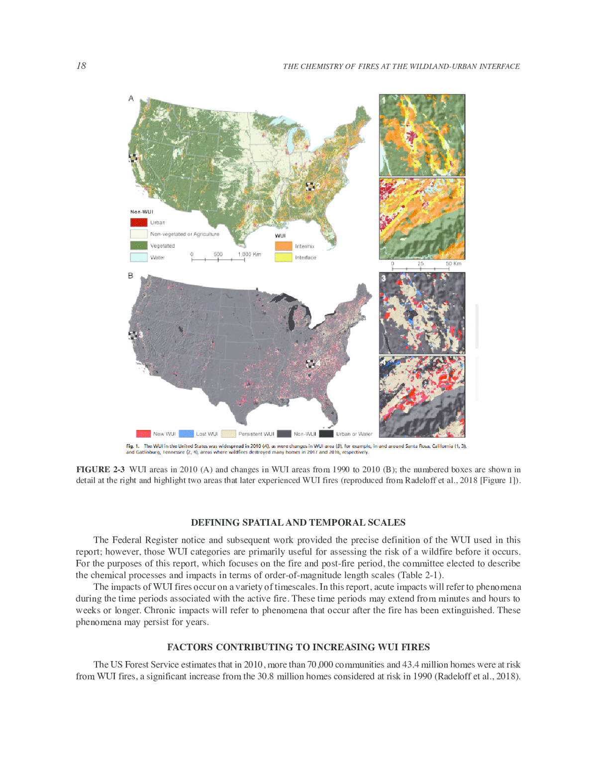
In the two decades since the Federal Register definition was published, the WUI has evolved across the United States, primarily through expansion. Radeloff et al. (2018) used US Census data to estimate that from 1990 to 2010, the number of new houses in WUI communities in the United States grew from 30.8 to 43.4 million and land area grew from 581,000 to 770,000 km2. This made WUI land area the largest growing land use type in the contiguous United States. Figure 2-3 shows WUI areas in 2010, highlighting two areas that experienced WUI fires that are described in the examples later in this chapter (Northern California and Gatlinburg, Tennessee). Although this report uses the definition of the WUI developed by the US Forest Service (Stewart et al., 2007), recent studies have suggested alternatives (Ager et al., 2019; Hanberry, 2020).
Finding: The number and spatial extent of WUI communities is growing rapidly.

DEFINING SPATIAL AND TEMPORAL SCALES
The Federal Register notice and subsequent work provided the precise definition of the WUI used in this report; however, those WUI categories are primarily useful for assessing the risk of a wildfire before it occurs. For the purposes of this report, which focuses on the fire and post-fire period, the committee elected to describe the chemical processes and impacts in terms of order-of-magnitude length scales (Table 2-1).
The impacts of WUI fires occur on a variety of timescales. In this report, acute impacts will refer to phenomena during the time periods associated with the active fire. These time periods may extend from minutes and hours to weeks or longer. Chronic impacts will refer to phenomena that occur after the fire has been extinguished. These phenomena may persist for years.
FACTORS CONTRIBUTING TO INCREASING WUI FIRES
The US Forest Service estimates that in 2010, more than 70,000 communities and 43.4 million homes were at risk from WUI fires, a significant increase from the 30.8 million homes considered at risk in 1990 (Radeloff et al., 2018).
TABLE 2-1 Spatial Scales of Atmospheric Processes Impacting the Chemistry and Exposures Associated with WUI Fires
| Length Scale (distance from flame front; km) | Descriptor | Atmospheric Processes Occurring at This Length Scalea |
|---|---|---|
| ≤1 | Immediate | Complex heat transfer from fire to fuels; rapid temperature evolution; effects of meteorologically induced and buoyancy-induced fluid dynamic interactions; chemical production of many of the emissions associated with health effects; chemical interaction with fire retardants; extremely high potential exposures |
| 1–10 | Near-field | Large-scale deposition of emissions; chemistry associated with mixing of fire plume with ambient air; some rapid initial aging of fire plume due to reactive intermediates; fire residues contaminating burned area |
| 10–100 | Local | Some aging may have occurred; concentrations and potential exposures are still high |
| 100–1,000 | Regional | Additional mixing of fire plume with ambient air; complex gas and particulate matter chemistry |
| >1,000 | Continental | Long-range transport of plumes with complex gas and particulate matter chemistry |
a This order-of-magnitude scale is used conceptually in this report to demarcate differences in chemical and physical processes and define how exposure may be impacted. These demarcations are not precise and are influenced by factors like meteorology and topography.
In the past ten years, wildfires have destroyed tens of thousands of structures (USFS, n.d.). Three main factors have driven the increase in WUI fires: (1) the expansion of areas at the WUI, (2) climate change, and (3) land management practices at the WUI.
The Expanding WUI
In 2000, the WUI made up 465,614 km2 of the continental United States, a 52 percent expansion from 1970. Researchers project that its geographic size will grow by more than 10 percent by 2030 (Theobald and Romme, 2007). While population growth in general has increased the number of people living in the WUI, stronger effects have come from the deconcentration of populations (e.g., moving to the suburbs and exurbs), population shifts to the American West and Southeast, and an increased interest in “natural amenities” such as living in woodland areas. This is expected to continue (Hammer et al., 2009; Marks, 2021). Some research suggests that the main drivers of the migration to the WUI are demographic trends, including “socioeconomic objectives (e.g., rising housing prices in urban areas, access to resources and amenities, aesthetics, and increased access to nature) and structural societal limits (e.g., zoning laws, growth incentives, and land use)” (Peterson et al., 2021).
Increased development at the WUI has also increased human contact with wildland areas (Radeloff et al., 2018). Human-started wildfires accounted for 84 percent of all wildfires in two decades (1992–2012) of government records (Balch et al., 2017), so increased development at the WUI has also increased the risk of accidental fires at the WUI.
Simultaneously, as WUI areas expand, fires that start in wildland areas are more likely to burn wildland vegetation near WUI developments (Radeloff et al., 2005). These fires therefore have a greater chance of igniting homes or other structures at the WUI. Increased human contact with the WUI, as well as increased wildfire contact with human development and suburban/urban structures, both due to the rapid expansion of new construction at the WUI, resulted in 44.9 percent of the WUI and 17.5 million people between 2000 and 2010 being at risk of a wildfire occurring (Thomas and Butry, 2014). Furthermore, WUI communities are more vulnerable to fire events because geographical barriers make it harder to suppress fires in the WUI (Peterson et al., 2021).
Impacts of Climate Change
As the risk of wildfires coming into contact with communities at the WUI increases, so does the risk of wildfires igniting and spreading faster than humans can control them. Climate change has increased the frequency and
length of droughts, particularly in the American West, which dry out soil and vegetation (USGCRP, 2018). This makes wildland vegetation more likely to ignite and to burn rapidly once ignited, reaching more communities at the expanded WUI (Peterson et al., 2021).
Greenhouse effects caused by increased atmospheric carbon dioxide concentrations have dried the air at the same time as droughts have become longer and more common (Liu et al., 2014). This makes it easier for fires to spread and reduces the likelihood of a precipitation event that would control or exterminate the fire. Based on climate projections, the risk of wildfires is projected to continue to increase in most areas of the world as climate change worsens (Bowman et al., 2020; Hurteau et al., 2019; Liu et al., 2015; Sun et al., 2019; Turco et al., 2018). While extreme drought conditions are more prevalent in the American West, drier weather conditions across the United States pose a risk for wildfire spread in any climate. For example, the Chimney Tops 2 Fire in Great Smoky Mountains National Park and nearby Gatlinburg, Tennessee, occurred in 2016 when much of the southeastern United States had been under “exceptional drought,” or extremely dry, conditions in the months before the fire.
While the short-term effects of climate change, like drought, directly increase fire risk, in the long term, the situation is more complex. Over years or decades, climate can affect factors like fuel buildup, with a drought in one year reducing the amount of fuel available the next. A recent study used a model to integrate ecohydrology, fire spread, and fire effects to simulate 60 years of vegetation, fuel development, and wildfire in an area in the southern Sierra Nevada, California. The study modeled increased temperature and drought, both with and without wildfire. In the short term, high temperature, low precipitation, and high fuel loading led to increased area burned, as expected. However, in the long term, increased temperature led to decreased vegetation and increased fuel decomposition, which reduced fuels and area burned. After the first decade, cycles of large fire years occurred (Kennedy et al., 2021).
Zhong et al. (2021) model how land use and land cover changes will change local atmospheric conditions, including increasing land surface temperature and reducing precipitation, which will in turn lead to longer fire seasons and more extreme fire-weather conditions across the United States. As land use changes exacerbate wildfire risk, climate change and increasing development into the WUI exacerbate the conditions under which a wildfire can ignite and spread. This creates a feedback loop in which fires at the WUI become more likely, frequent, and dangerous.
Land Management at the WUI
Past wildland management practice has been recognized as an additional driver of increasing WUI fire threat. The wildland ecosystem in the western United States mostly evolved with wildfire disruption of the landscape (Hessburg, 2021). However, fire exclusion and suppression have been the emphasis of wildland fire management in the region in the past century (Calkin et al., 2015; Stephens and Ruth, 2005). This land management practice and past logging activities have contributed toward changes in forests in terms of vegetation age, structure, continuity, and density (Calkin et al., 2015; McIntyre et al., 2015; Schoennagel et al., 2017). Fire exclusion has resulted in fuel accumulation and wildlands that are less fire resistant, and evidence indicates that a transition has occurred from a regular, less intense surface fire regime to infrequent, large crown fires in the region (Calkin et al., 2015; Schoennagel et al., 2017). Ironically, the increase in assets at risk due to the growth of the WUI and sociopolitical pressures continues to compel the suppression response to wildfires (Calkin et al., 2015; Kolden, 2019), although there is a growing realization of the need to rectify current wildland management practices (Hessburg, 2021; Kolden, 2019; Schoennagel et al., 2017).
Finding: The threat of severe fires at the WUI is growing rapidly.
THE IMPACTS OF WUI FIRES
Wildfires have major economic, environmental, and social impacts. These include the costs associated with material losses, damage to human health, environmental destruction, and the operational costs of disaster response, such as firefighting efforts. Because of the wide range of impacts, numerous ways exist to measure the incidence
TABLE 2-2 Statistics that Describe Impacts of WUI Fires in the United States
| Measure of Impact | Statistic | Year | Reference |
|---|---|---|---|
| Fire-exposure-related civilian deaths | 15 deaths* | 2017 | Thomas et al., 2017 |
| Fire-exposure-related firefighter deaths | 18 deaths* | 2017 | Thomas et al., 2017 |
| Acute-smoke-exposure-related civilian deaths | 2,940–21,095 deaths* | 2017 | Thomas et al., 2017 |
| Civilian injuries | 88 injuries* | 2017 | Thomas et al., 2017 |
| Firefighter injuries | 260 injuries* | 2017 | Thomas et al., 2017 |
| Costs due to injuries | $177,450,535* | 2017 | Thomas et al., 2017 |
| Total acres burned (from all wildfires) | 10,122,336 acres | 2020 | NIFC, 2020 |
| Structures destroyed by fire | 17,904 | 2020 | NIFC, 2020 |
| Residences destroyed by fire | 9,630 | 2020 | NIFC, 2020 |
NOTE: NIFC = National Interagency Fire Center; * estimated values or ranges.
and severity of wildfires. Table 2-2 provides statistics from recent WUI fires, showing several types of impacts and how they were measured. The sources listed in the table are the most recent available, at the time of this report, that are specific to WUI fires. While some impacts, such as number of deaths and costs of property damage, are straightforward to measure, other impacts, like the effects of psychological distress, are not.
The 2021 fire season provides many examples of the growing complexity of impacts of WUI fires as well as the complexity of measuring those impacts. The Caldor Fire was only the second fire (after the Dixie Fire, during the same season) ever to burn across the natural boundary of the Sierra Nevada Mountains (Reinhard and Patel, 2021). As a result, 22,000 residents of Lake Tahoe were told to evacuate, and many lost their homes. The smoke from the fire affected millions of people in several states. In 2020, one in seven Americans (about 47 million people) experienced dangerous air quality from wildfire smoke (Carlsen et al., 2020; based on an analysis of US Environmental Protection Agency AirNow data). Effects of smoke exposure include discomfort (such as headaches, fatigue, and sore throats), severe health effects (for example, particulates exposure can cause cardiac events), and disruption of activities, as people were told to stay indoors. In some cases, the conditions persisted for weeks or even months. Entire communities were lost to fires, such as the town of Greenville, California—a town where people had relocated after losing homes in Paradise, which was destroyed by 2018’s Camp Fire. Dry conditions made the fires difficult to control. For example, the Marshall Fire, which destroyed communities in Louisville and Superior, Colorado, in December 2021, burned grasslands in a suburban region that were extremely dry due to months of drought. The US Forest Service stopped performing prescribed burns of federal lands in 2021 because the agency was overwhelmed with fighting wildfires (Sommer, 2021).
In the United States, in many cases, there is a lack of high-quality data specific to WUI fires. It is difficult to extract WUI-specific data for several reasons. First, fires are heterogeneous; they may start as purely wildland fires and later enter populated areas, burning structures and other elements of the built environment for only part of the event timeline. Second, smoke travels long distances, affecting ambient and indoor air quality at regional or even continental scales, which are well beyond the immediate fire zone. When effects are geographically distant from the fire, it can be difficult to confidently attribute environmental impacts, disease, and exacerbation of health conditions to the fire and the emissions that originated at the WUI. Finally, wildfires have both tangible and intangible impacts; while the tangible impacts might be straightforward to measure, “the intangible and potentially long-term wellbeing costs associated with physical injury, pain, psychological distress and behavioral change are much more difficult to evaluate” (Johnston et al., 2021, p. 2).
Fire Incidence by Region
While the expansion of WUI land areas has been more rapid in the eastern United States than in the West, almost half of the WUI in the East is characterized by low-severity fire regimes (Theobald and Romme, 2007).
Only 12 percent of the WUI in the West is characterized as low severity, resulting in a greater risk of wildfires occurring in the western United States.
Some of the greatest densities of WUI communities are in the eastern United States, where intermix communities are widespread (Figure 2-2). As Figure 2-3 shows, WUI areas are growing rapidly in the eastern United States. These denser populations and growing WUI areas mean more people in potential wildfire regions. In 2020, over 33,000 fires occurred in eastern states and burned just under 0.7 million acres (Wibbenmeyer and McDarris, 2021). By contrast, the 26,000 wildfires in the West burned approximately 9.5 million acres. While these larger wildfires in the West attract attention and can have large regional impacts, the size of a fire is not necessarily predictive of economic damage. The Marshall Fire, described later in this chapter, was the most economically destructive fire in Colorado history, yet burned a relatively small area of 6,200 acres. Factors that influence fire severity include land use, vegetation, terrain, weather, and fire history. Although the US Forest Service led the development of Wildfire Risk to Communities (wildfirerisk.org), there are no current federal definitions related to fire risk or fire severity specific to the WUI. California has defined “Fire Hazard Severity Zones” that provide a more nuanced view of this issue at the state level; however, the details of how California determines these zones are not transparently available (OSFM, 2021).
Finding: WUI fires have different characteristics in different regions of the United States that likely lead to different risks, but a comprehensive mapping of communities at risk of fire, and the severity of that risk, is not available.
Demographics of Impacted Populations
Not all populations are equally affected by WUI fires. The limited number of studies that exist examine different regions and draw a variety of conclusions about which populations are most impacted. A 2021 study used wildfire data from the California Fire and Resource Assessment Program and the National Interagency Fire Center and demographic data from the American Community Survey to examine the populations living in areas burned by wildfire in California from 2000 to 2020 (Masri et al., 2021). In addition to a near doubling of the populations in affected areas (largely due to an increase in the area burned by wildfires), the study found that these areas contained lower proportions of racially minoritized groups in general but higher proportions of Native American populations; higher proportions of older residents; and higher proportions of low-income residents, lower median household incomes, and lower home values.
By contrast, a 2020 study of fires in Southern California since 1980 found that WUI neighborhoods in that region are predominantly white and affluent, with increasingly expensive housing (Garrison and Huxman, 2020). Another 2020 study looked specifically at the risks of wildfire to residents of subsidized housing in California (Gabbe et al., 2020). This study was motivated by the difficulties low-income households face in recovering from such disasters, as well as the fact that policy makers can reduce the risk to current and future subsidized housing. The study found that a higher proportion of subsidized housing is located outside the WUI, but that residents of 140,000 subsidized housing units as well as other vulnerable populations in the WUI do live at risk.
These three studies of impacts in California highlight an important point about the availability of information on WUI fires and wildfires more generally: the literature on WUI fires is often focused on the West, particularly the State of California. As discussed earlier in this chapter, WUI fires are not strictly a western phenomenon; however, likely due to a variety of contributing factors, western fires are more strongly represented in the existing research that informed this report. The committee acknowledges the potential bias that this fact introduces to its work. Until broader research can fill in information gaps on the demographics of impacted populations in the East, and elsewhere in the United States, the existing literature, which focuses on the West, can be used to analyze the problem of WUI fires, with an acknowledgment of the limitations.
Finding: Although the majority of the WUI is found in the eastern United States, research on the impacts of WUI fires is more abundant for California than other US states.

To begin addressing these information gaps, simple geographic information system analyses could be conducted to combine existing data sets in new ways. In Figure 2-4, national data on the distribution of low-income households has been combined with Radeloff et al.’s WUI maps and a data set that shows the spatial distribution of burned areas from 2021 wildfires (EPA, 2021; Radeloff et al., 2018; Wiedinmyer et al., 2011). The data set on burned areas uses thermal hot spot detection to locate fires; therefore, the data set includes open biomass burning, including wildfires, agricultural fires, and prescribed burning (Wiedinmyer et al., 2011).
This analysis, done by the committee using the above sources, shows that, while 32.5 percent of households in the contiguous United States are categorized as low income (i.e., with income less than two times the federal poverty level; data from the Census Bureau’s American Community Survey 2014–2018), 28.5 percent of households in the WUI are categorized as low income, and 36.3 percent of households in WUI areas that burned in 2020 are categorized as low income. This analysis is a simple example of the types of insights that could emerge from combining a precise definition of WUI communities with other mappings. These types of analyses could inform future research or help decision-makers prioritize research.
Finding: Quantitative and widely accepted definitions of WUI communities would enable mappings of risk and help define future research priorities.
USING EXAMPLES TO CONTEXTUALIZE WUI FIRES
The earlier sections of this chapter discuss how pervasive WUI communities and fires are; however, few data are available on how WUI fires differ from other wildfires. For the purposes of this report, the committee chose to explore a set of recent examples of the state of available information. The five WUI fires presented in this section
and discussed throughout this report took place in North America within the past 10 years. They were identified by the committee through their own research and through conversations with experts as cases that exhibit distinct characteristics and for which a comparatively large amount of documentation is available. This section provides some situational details for each example fire. A table that contains the results of the committee’s literature search for each fire can be found in Appendix C of the report. Later chapters refer to what is known about these fires to enable a deeper discussion of the information needs in WUI fire research.
Waldo Canyon Fire (2012)
The Waldo Canyon Fire was first reported on Saturday, June 23, 2012. It began in the Pike National Forest, approximately three miles west of Colorado Springs, Colorado. The fire burned 18,247 acres over 18 days and was reported as fully contained on July 10, 2012 (City of Colorado Springs, 2013). About 19 percent of the burn was classified as high severity, 40 percent as moderate severity, and 41 percent as low severity. In the severe Colorado wildfire season of 2012, the Waldo Canyon Fire stands out with its high social impact, which was due to its close proximity to Colorado Springs and other communities. The fire forced the evacuation of more than 32,000 people, including 22,000 residents within a two-hour period on June 26, 2012 (Chin et al., 2016). There were two documented fatalities (City of Colorado Springs, 2013).
The Waldo Canyon Fire was, at the time, the most destructive wildfire in Colorado history, destroying more than 300 homes, mostly in the Mountain Shadows neighborhood. These homes were downslope of a major topographic ridge that normally would have kept the fire from spreading. However, erratic winds exceeding 100 km per hour, which were fueled by dry conditions, caused the fire to cross the ridge into the residential neighborhood (Chin et al., 2016). The Colorado Springs Fire Department invited the National Institute of Standards and Technology (NIST) and the US Forest Service Fire and Environmental Research Applications Team to collect post-incident data from the fire, specifically in the Mountain Shadows community. The report found that 1,455 primary structures had existed in the community. Of these, over 300 primary structures, as classified in that report, were completely destroyed, and over 100 more structures were damaged (Maranghides et al., 2015). The Waldo Canyon Fire had losses estimated at US$454 million (FEMA, 2021). An investigation by the US Forest Service and the Federal Bureau of Investigation later determined that the fire had been caused by human activity.
Horse River Fire (2016)
On May 1, 2016, a fire started to the southwest of Fort McMurray, Alberta, Canada, in what became known as the Horse River Fire. Fort McMurray is a city bordered by boreal forest in the Athabasca oil sands region of Alberta and had a population of 78,382 in 2015 (MSB, 2015). The fire quickly spread to populated areas, exacerbated by record-setting high temperatures and low humidity (McGrath, 2016). More than 88,000 residents of the city and surrounding areas were evacuated on May 3, 2016 (McGee, 2019). The fire was declared contained on July 5, 2016, but was not fully extinguished until August of the following year.
Over 1.4 million acres of land were burned (Gabbert, 2017), including 2,579 homes (Wood Buffalo Economic Development, 2017). At the time, the Horse River Fire was the costliest natural disaster in Canadian history, with insurance claims amounting to C$3.58 billion (Suncor Energy Inc., 2018). Today, it remains the most expensive wildfire in Canadian history. There were no fatalities and no injuries. The specific cause of the fire is still unknown, but law enforcement determined that it was most likely the result of human activity.
Chimney Tops 2 Fire (2016)
The 2016 wildfire that engulfed Gatlinburg, Tennessee, became known as the Chimney Tops 2 Fire. First observed around 5:30 p.m. on November 23, it started as a 1.5-acre wildland fire in Great Smoky Mountains National Park, about 5.5 miles away from city limits (Culver, 2016). The steep topography of Chimney Tops prevented firefighters from immediately extinguishing the fire. When high winds picked up four days later on November 27, the fire rapidly grew to 35 acres. The next day, in addition to causing the original fire area to spread, high wind conditions carried firebrands up to one mile and caused new fires to ignite to the north,
closer to the city. On November 28, the fire traveled three miles toward Gatlinburg in less than five hours. That evening, the entire Gatlinburg area including nearby Pigeon Forge, which included over 14,000 residents, was placed under a mandatory evacuation order.
A few hours later, around 2:00 a.m. on November 29, the weather shifted, with wind speeds dying down, replaced by steady rain. While the fire was not fully contained until about two weeks later, its rapid spread had ended. There were 14 deaths, 2,500 destroyed or damaged structures, and about 17,000 acres burned (Guthrie et al., 2017). One year after the fire, damages were estimated at over US$500 million (Songer, 2017). The cause of the fire was determined to be arson.
Camp Fire (2018)
The Camp Fire was first reported on November 8, 2018, in Butte County, California. Strongly driven toward populated areas by northeasterly winds, it was 100 percent contained on November 25, 2018, after burning 153,336 acres over 17 days (Mohler, 2019). Burned areas included both interface- and intermix-type WUI (Kramer et al., 2019). Nineteen percent of the fire area was classified as very low soil burn severity, 63 percent as low soil burn severity, 16 percent as moderate soil burn severity, and 2 percent as high soil burn severity (WERT, 2018). The fire destroyed the town of Paradise, California, and damaged the neighboring communities of Magalia, Butte Creek Canyon, and Concow.
The fire resulted in 85 fatalities and three documented injuries (CAL FIRE, 2019). Some 18,804 structures were destroyed, including 13,696 single-family residences, 276 multi-family residences, 4,923 other, minor structures, and 528 commercial structures. An additional 462 single-family residences, 25 multi-family residences, and 102 commercial structures were damaged, but not completely destroyed (Hawks, 2018). In 2019, California Department of Forestry and Fire Protection investigators determined that the cause of the Camp Fire was electrical transmission lines that ignited vegetation at two ignition sites (Mohler, 2019). Pacific Gas and Electric Company, the utility responsible, later pleaded guilty to 84 counts of involuntary manslaughter and paid damages to the wildfire’s victims. The Camp Fire was the costliest disaster worldwide in 2018, totaling US$16.5 billion in losses (NIST, 2021; Ruiz-Grossman, 2019).
NIST prepared an extensive case study of the fire’s spread based on abundant observations by first responders and other first-hand witnesses (Maranghides et al., 2021). Because this fire is recent, the committee acknowledges that relevant chemistry data and analyses may still be unpublished at this time.
Marshall Fire (2021)
At 10:00 a.m. on December 30, 2021, high winds, which blew over 115 miles per hour in some places, helped drive fast-moving grass fires that rapidly spread through the densely populated suburban areas of Superior and Louisville in Boulder County, Colorado (CPR, 2021; Markus, 2022). The most destructive fire in Colorado history, the Marshall Fire destroyed over 1,000 residential structures and businesses and burned over 6,000 acres (Metzger, 2022). Burn severity information was not available at the time of the publication of this report. High winds created 40-foot-high flames in some areas. At 11:44 a.m. on December 30, residents east of the fire were placed under an evacuation order as firefighters struggled to contain the fire, which was burning in multiple places (Brown and Paul, 2022). Two hours later, a reverse-911 call ordered more residents to evacuate as high winds continued.
The fire was extinguished by heavy snowfall on Friday, December 31, when up to 10 inches of snow blanketed the Denver suburbs. As temperatures dropped below freezing, 7,500 customers of the electric company, Xcel Energy, were without electricity, and 13,000 people in the Boulder area were without gas (CPR, 2022). One person was found dead and another reported missing (CBS Denver, 2022). President Biden approved a major disaster declaration on January 1, 2022. The total value of homes destroyed is estimated at more than $500,000,000, while the value of commercial damage is still being calculated (Cobb, 2022).
This fire occurred only a few months before this report’s publication. The cause of the fire is still unknown (Boulder OEM, 2022). Facts about the event will continue to emerge; although many researchers took part in post-fire chemical analyses of air, water, and soil, chemical data will take time to appear in the peer-reviewed literature.
FINDINGS FROM RECENT EXAMPLES OF WUI FIRES
Appendix C describes the literature available on these fires, which the committee used in later chapters, along with additional data from wildfires that the committee found relevant. Despite these studies being relatively widely studied, there are still significant data gaps, especially information on the fuels, combustion, emissions, and atmospheric chemistry.
Finding: There is a paucity of chemical information available about WUI fires.
Where data are available (e.g., from state and local agencies), it often must be drawn from air and water quality monitoring networks, and these networks are not designed specifically for collecting data relevant to wildfires and their emissions. However, supplemental data collection is not generally prioritized during WUI fires, as authorities’ first concern is life and property protection. Additionally, the lack of technological and workforce availability limits research efforts. These are some of the challenges facing the research efforts needed to understand the effects of WUI fires.
States like California do more sampling and chemical testing in areas affected by fires than other states do (CalRecycle, 2022). For example, Colorado recommends against testing soil at affected parcels prior to residents returning to rebuild, “as testing can be difficult, expensive and may cause delays in being able to handle the waste” (CDPHE, 2020, p. 1).
Finding: Advancing the understanding of WUI fires will take advance planning and prioritization of data collection during WUI fires.
REFERENCES
Ager, A. A., P. Palaiologou, C. R. Evers, M. A. Day, C. Ringo, and K. Short. 2019. “Wildfire Exposure to the Wildland Urban Interface in the Western US.” Applied Geography 111: 102059. https://doi.org/10.1016/j.apgeog.2019.102059.
Balch, J. K., B. A. Bradley, J. T. Abatzoglou, R. C. Nagy, E. J. Fusco, and A. L. Mahood. 2017. “Human-Started Wildfires Expand the Fire Niche across the United States.” Proceedings of the National Academy of Sciences of the United States of America 114 (11): 2946–2951. https://doi.org/10.1073/pnas.1617394114.
Boulder OEM (Boulder Office of Emergency Management). January 6, 2022. “Boulder County Releases Updated List of Structures Damaged and Destroyed in the Marshall Fire.” https://www.bouldercounty.org/news/boulder-county-releases-updated-list-of-structures-damaged-and-destroyed-in-the-marshall-fire/ (accessed January 31, 2022).
Bowman, D. M. J. S., C. A. Kolden, J. T. Abatzoglou, F. H. Johnston, G. R. van der Werf, and M. Flannigan. 2020. “Vegetation Fires in the Anthropocene.” Nature Reviews Earth & Environment 1 (10): 500–515. https://doi.org/10.1038/s43017-020-0085-3.
Brown, J., and J. Paul. January 6, 2022. “The Minute-by-Minute Story of the Marshall Fire’s Wind-Fueled Tear through Boulder County.” Colorado Sun. https://coloradosun.com/2022/01/06/marshall-fire-boulder-county-timeline/.
CAL FIRE (California Department of Forestry and Fire Protection). 2019. “Camp Fire Incident.” https://www.fire.ca.gov/incidents/2018/11/8/camp-fire/.
Calkin, D. E., M. P. Thompson, and M. A. Finney. 2015. “Negative Consequences of Positive Feedbacks in US Wildfire Management.” Forest Ecosystems 2: 9. https://doi.org/10.1186/s40663-015-0033-8.
CalRecycle. 2022. Wildfire Cleanup Process and Order of Operations. https://calrecycle.ca.gov/disaster/wildfires/operations/.
Carlsen, A., S. Mcminn, and J. Eng. 2020. “1 in 7 Americans Have Experienced Dangerous Air Quality Due to Wildfires This Year.” National Public Radio. https://www.npr.org/2020/09/23/915723316/1-in-7-americans-have-experienced-dangerous-air-quality-due-to-wildfires-this-ye (accessed February 25, 2022).
CBS Denver. January 21, 2022. “Marshall Fire: Investigators Consider Underground Mine Fire in Origin.” CBS Denver. https://denver.cbslocal.com/2022/01/21/marshall-fire-boulder-county-underground-mine-fire/.
CDPHE (Colorado Department of Public Health and the Environment). November 5, 2020. “Important Wildfire Debris Guidance.” https://www.larimer.org/sites/default/files/uploads/2020/cdphe_important_wildfire_debris_guidance_0.pdf.
Chin, A., L. An, J. L. Florsheim, L. R. Laurencio, R. A. Marston, A. P. Solverson, G. L. Simon, E. Stinson, and E. Wohl. 2016. “Investigating Feedbacks in Human-Landscape Systems: Lessons Following a Wildfire in Colorado, USA.” Geomorphology 252: 40–50.
City of Colorado Springs. 2013. Waldo Canyon Fire Final After Action Report. Colorado Springs, CO: City of Colorado Springs.
Cobb, E. January 30, 2022. “‘A Hurricane of Fire’: How the Marshall Fire Tore through Boulder County.” Daily Camera. https://www.dailycamera.com/2022/01/30/hurricane-of-fire/.
CPR (Colorado Public Radio). December 31, 2021. “Boulder County Fires: More Than 500 Houses Burn, Tens of Thousands Evacuate as Fires Continue to Spread.” CPR News. https://www.cpr.org/2021/12/30/boulder-county-grass-fires/.
CPR. January 1, 2022. “Boulder County Fires: Three Missing from Marshall, Superior Are Suspected Dead; Thousands without Gas and Electricity in Freezing Temps.” CPR News. https://www.cpr.org/2022/01/01/boulder-county-fires-water-shut-off-in-superior-thousands-without-gas-and-electricity-in-freezing-temps/.
Culver, A. December 13, 2016. “Timeline: Gatlinburg Wildfires.” WATE. https://www.wate.com/news/local-news/timeline-gatlinburg-wildfires/ (accessed December 23, 2021).
EPA (US Environmental Protection Agency). 2021. EJScreen: Environmental Justice Screening and Mapping Tool, 2021 version. www.epa.gov/ejscreen (accessed October 19, 2021).
Federal Register. January 4, 2001. “Urban Wildland Interface Communities within the Vicinity of Federal Lands That Are at High Risk from Wildfire.” Federal Register 66 (01-52): 751–777. https://www.federalregister.gov/documents/2001/01/04/01-52/urban-wildland-interface-communities-within-the-vicinity-of-federal-lands-that-are-at-high-risk-from.
FEMA (Federal Emergency Management Agency). February 11, 2021. “Cedar Heights Saved during Waldo Canyon Fire.” https://www.fema.gov/case-study/cedar-heights-saved-during-waldo-canyon-fire.
FMB (Fire Management Board). 2019. Federal Wildland Fire Policy Terms and Definitions. https://www.nwcg.gov/sites/default/files/docs/eb-fmb-m-19-004a.pdf.
Gabbe, C. J., G. Pierce, and E. Oxlaj. 2020. “Subsidized Households and Wildfire Hazards in California.” Environmental Management 66 (5): 873–883.
Gabbert, B. November 21, 2017. “Official Report Shows Fort McMurray Fire Created Lightning-Started Fires 26 Miles Away.” Wildfire Today. https://wildfiretoday.com/2017/11/21/official-report-shows-fort-mcmurray-fire-created-lightning-started-fires-26-miles-away/.
Garrison, J. D., and T. E. Huxman. 2020. “A Tale of Two Suburbias: Turning Up the Heat in Southern California’s Flammable Wildland-Urban Interface.” Cities 104: 102725.
Guthrie, V. H., M. J. Finucane, P. E. Keith, and D. Bart Stinnett. 2017. After Action Review of the November 28, 2016, Firestorm. Spring, TX: ABS Group. https://wildfiretoday.com/documents/AAR_ChimneyTops2.pdf.
Hammer, R. B., S. I. Stewart, and V. C. Radeloff. 2009. “Demographic Trends, the Wildland–Urban Interface, and Wildfire Management.” Society & Natural Resources 22 (8): 777–782. https://doi.org/10.1080/08941920802714042.
Hanberry, B. B. 2020. “Reclassifying the Wildland–Urban Interface Using Fire Occurrences for the United States.” Land 9: 225. https://doi.org/10.3390/land9070225.
Hawks, D. 2018. Camp Fire. Carson City, NV: Nevada Division of Forestry.
Hessburg, P. F. 2021. “Wildfire and Climate Change Adaptation of Western North American Forests: A Case for Intentional Management.” Ecological Applications 31 (8): e02432.
Hurteau, M. D., S. Liang, A. L. Westerling, and C. Wiedinmyer. 2019. “Vegetation-Fire Feedback Reduces Projected Area Burned under Climate Change.” Scientific Reports 9 (1): 2838. https://doi.org/10.1038/s41598-019-39284-1.
Johnston, D., Y. K. Onder, H. Rahman, and M. Ulubasoglu. 2021. Evaluating Wildfire Exposure: Using Wellbeing Data to Estimate and Value the Impacts of Wildfire. https://mpra.ub.uni-muenchen.de/109652/.
Kennedy, M. C., R. R. Bart, C. L. Tague, and J. S. Choate. 2021. “Does Hot and Dry Equal More Wildfire? Contrasting Short- and Long-Term Climate Effects on Fire in the Sierra Nevada, CA.” Ecosphere 12: e03657. https://doi.org/10.1002/ecs2.3657.
Kolden, C. A. 2019. “We’re Not Doing Enough Prescribed Fire in the Western United States to Mitigate Wildfire Risk.” Fire 2 (2): 30.
Kramer, H. A., M. H. Mockrin, P. M. Alexandre, and V. C. Radeloff. 2019. “High Wildfire Damage in Interface Communities in California.” International Journal of Wildland Fire 28 (9): 641–650.
Liu, Y., S. Goodrick, and W. Heilman. 2014. “Wildland Fire Emissions, Carbon, and Climate: Wildfire–Climate Interactions.” Forest Ecology and Management 317: 80–96.
Liu, Z., M. C. Wimberly, A. Lamsal, T. L. Sohl, and T. J. Hawbaker. 2015. “Climate Change and Wildfire Risk in an Expanding Wildland–Urban Interface: A Case Study from the Colorado Front Range Corridor.” Landscape Ecology, 30 (10): 1943–1957.
Maranghides, A., D. McNamara, R. Vihnanek, J. Restaino, and C. Leland. 2015. A Case Study of a Community Affected by the Waldo Fire – Event Timeline and Defensive Actions. NIST Technical Note 1910. Gaithersburg, MD: NIST.
Maranghides, A., E. Link, W. Mell, S. Hawks, M. Wilson, W. Brewer, C. Brown, B. Vihnaneck, and W. D. Walton. 2021. A Case Study of the Camp Fire – Fire Progression Timeline. Gaithersburg, MD: NIST. https://nvlpubs.nist.gov/nistpubs/TechnicalNotes/NIST.TN.2135.pdf.
Marks, J. 2021. “The Wildland Urban Interface Is Growing in the United States.” Geography Realm. https://www.geography-realm.com/the-wildland-urban-interface-is-growing-in-the-united-states/ (accessed February 26, 2022).
Markus, B. January 5, 2022. “Boulder County Firefighters Lost Crucial Early Minutes Because They Couldn’t Find the Start of the Marshall Fire.” CPR News. https://www.cpr.org/2022/01/05/boulder-county-marshall-fire-timeline/.
Masri, S., E. Scaduto, Y. Jin, and J. Wu. 2021. “Disproportionate Impacts of Wildfires among Elderly and Low-Income Communities in California from 2000–2020.” International Journal of Environmental Research and Public Health 18 (8): 3921. https://doi.org/10.3390/ijerph18083921.
McGee, T. K. 2019. “Preparedness and Experiences of Evacuees from the 2016 Fort McMurray Horse River Wildfire.” Fire 2 (1): 13.
McGrath, M. May 5, 2016. “‘Perfect Storm’ of El Niño and Warming Boosted Alberta Fires.” BBC News. https://www.bbc.com/news/science-environment-36212145.
McIntyre, P. J., J. H. Thorne, C. R. Dolanc, A. L. Flint, L. E. Flint, M. Kelly, and D. D. Ackerly. 2015. “Twentieth-Century Shifts in Forest Structure in California: Denser Forests, Smaller Trees, and Increased Dominance of Oaks.” Proceedings of the National Academy of Sciences 112 (5): 1458–1463.
Metzger, H. January 3, 2022. “Perimeter of Marshall Fire 100% Contained after Burning over 6,000 Acres.” Colorado Politics. https://www.coloradopolitics.com/denver/marshall-fire-100-percent-contained/article_6ee3eb84-f49a-5bbe-8ea7-d2a26bec620d.html (accessed March 25, 2022).
Mohler, M. May 15, 2019. “CAL FIRE Investigators Determine the Cause of the Camp Fire.” California Department of Forestry and Fire Protection. https://www.fire.ca.gov/media/5121/campfire_cause.pdf.
MSB (Government of Alberta Municipal Services Branch). 2015. 2015 Municipal Affairs Population List. http://municipalaffairs.alberta.ca/documents/msb/2015_Municipal_Affairs_Population_List.pdf.
NIFC (National Interagency Fire Center). 2020. Wildland Fire Summary and Statistics Annual Report. https://www.predictiveservices.nifc.gov/intelligence/2020_statssumm/annual_report_2020.pdf.
NIST (National Institute of Standards and Technology). February 8, 2021. “New Timeline of Deadliest California Wildfire Could Guide Lifesaving Research and Action.” https://www.nist.gov/news-events/news/2021/02/new-timeline-deadliest-california-wildfire-could-guide-lifesaving-research.
OSFM (Office of the State Fire Marshal). 2021. “Fire Hazard Severity Zones.” https://osfm.fire.ca.gov/divisions/wildfire-planning-engineering/wildfire-prevention-engineering/fire-hazard-severity-zones/.
Peterson, G. C. L., S. E. Prince, and A. G. Rappold. 2021. “Trends in Fire Danger and Population Exposure along the Wildland–Urban Interface.” Environmental Science & Technology 55: 16257–16265. https://doi.org/10.1021/acs.est.1c03835.
Radeloff, V. C., R. B. Hammer, S. I. Stewart, J. S. Fried, S. S. Holcomb, and J. F. McKeefry. 2005. “The Wildland-Urban Interface in the United States.” Ecological Applications 15 (3): 799–805.
Radeloff, V. C., D. P. Helmers, H. A. Kramer, M. H. Mockrin, P. M. Alexandre, A. Bar-Massada, V. Butsic, T. J. Hawbaker, S. Martinuzzi, A. D. Syphard, and S. I. Stewart. 2018. “Rapid Growth of the US Wildland-Urban Interface Raises Wildfire Risk.” Proceedings of the National Academy of Sciences 115 (13): 3314–3319. https://doi.org/10.1073/pnas.1718850115.
Reinhard, S., and J. K. Patel. September 5, 2021. “Caldor Fire’s March to the Edge of South Lake Tahoe.” The New York Times. https://www.nytimes.com/interactive/2021/09/05/us/caldor-fire-lake-tahoe.html (accessed February 24, 2022).
Ruiz-Grossman, S. January 12, 2019. “California’s Camp Fire Was the Most Expensive Natural Disaster Worldwide in 2018.” Grist. https://grist.org/article/californias-camp-fire-was-the-most-expensive-natural-disaster-worldwide-in-2018/.
Schoennagel, T., J. K. Balch, H. Brenkert-Smith, P. E. Dennison, B. J. Harvey, M. A. Krawchuk, N. Mietkiewicz, P. Morgan, M. A. Moritz, R. Rasker, M. G. Turner, and C. Whitlock. 2017. “Adapt to More Wildfire in Western North American Forests as Climate Changes.” Proceedings of the National Academy of Sciences 114 (18): 4582–4590.
Sommer, L. August 10, 2021. “With Extreme Fires Burning, Forest Service Stops ‘Good Fires’ Too.” NPR https://www.npr.org/2021/08/09/1026137249/with-extreme-fires-burning-forest-service-stops-good-fires-too (accessed March 25, 2022).
Songer, J. November 27, 2017. “Gatlinburg One Year after the Devastating Wildfires Then and Now.” AL.com. https://www.al.com/outdoors/2017/11/gatlinburg_one_year_after_the.html.
Stephens, S. L., and L. W. Ruth. 2005. “Federal Fire Policy in the United States.” Ecological Applications 15 (2): 532–542.
Stewart, S. I., V. C. Radeloff, R. B. Hammer, and T. J. Hawbaker. 2007. “Defining the Wildland–Urban Interface.” Journal of Forestry 105 (4): 201–207. https://doi.org/10.1093/jof/105.4.201.
Sun, Q., C. Miao, M. Hanel, A. G. L. Borthwick, Q. Duan, D. Ji, and H. Li. 2019. “Global Heat Stress on Health, Wildfires, and Agricultural Crops under Different Levels of Climate Warming.” Environment International 128: 125–136. https://doi.org/10.1016/j.envint.2019.04.025.
Suncor Energy Inc. 2018. Volume 2 – Environmental Impact Assessment. Lewis In Situ Project. https://open.alberta.ca/dataset/f9e55e85-c164-4227-8be6-b45fb32f812f/resource/c3b4bfd4-c43f-495d-be5d-8e1d80e89554/download/vol2_sec18_socioeconomic.pdf (accessed March 25, 2022).
Theobald, D. M., and W. H. Romme. 2007. “Expansion of the US Wildland–Urban Interface.” Landscape and Urban Planning 83 (4): 340–354. https://doi.org/10.1016/j.landurbplan.2007.06.002.
Thomas, D. S., and D. T. Butry. 2014. “Areas of the U.S. Wildland–Urban Interface Threatened by Wildfire during the 2001–2010 Decade.” Natural Hazards 71: 1561–1585. https://doi.org/10.1007/s11069-013-0965-7.
Thomas, D., D. Butry, S. Gilbert, D. Webb, and J. Fung. 2017. The Costs and Losses of Wildfires: A Literature Survey. NIST Special Publication 1215. https://doi.org/10.6028/NIST.SP.1215.
Turco, M., J. J. Rosa-Canovas, J. Bedia, S. Jerez, J. P. Montavez, M. C. Llasat, and A. Provenzale. 2018. “Exacerbated Fires in Mediterranean Europe Due to Anthropogenic Warming Projected with Non-stationary Climate-Fire Models.” Nature Communications 9 (1): 3821. https://doi.org/10.1038/s41467-018-06358-z.
USFS (US Forest Service). n.d. “Fire Adapted Communities.” https://www.fs.usda.gov/managing-land/fire/fac.
USGCRP (US Global Change Research Program). 2018. Fourth National Climate Assessment, Volume II: Impacts, Risks, and Adaptation in the United States. Edited by D. R. Reidmiller, C. W. Avery, D. R. Easterling, K. E. Kunkel, K. L. M. Lewis, T. K. Maycock, and B. C. Stewart. Washington, DC: US Global Change Research Program. https://doi.org/10.7930/NCA4.2018.
WERT (State of California Watershed Emergency Response Team). November 29, 2018. CAMP FIRE Watershed Emergency Response Team Final Report. https://ucanr.edu/sites/Rangelands/files/304942.pdf.
Wibbenmeyer, M., and A. McDarris. 2021. “Wildfires in the United States 101: Context and Consequences.” Resources for the Future. https://www.rff.org/publications/explainers/wildfires-in-the-united-states-101-context-and-consequences/ (accessed February 25, 2022).
Wiedinmyer, C., S. K. Akagi, R. J. Yokelson, L. K. Emmons, J. A. Al-Saadi, J. J. Orlando, and A. J. Soja. 2011. “The Fire INventory from NCAR (FINN): A High Resolution Global Model to Estimate the Emissions from Open Burning.” Geoscientific Model Development 4 (3): 625–641. https://doi.org/10.5194/gmd-4-625-2011.
Wood Buffalo Economic Development. 2017. Wood Buffalo Economic Development Regional Data. http://www.oscaalberta.ca/wp-content/uploads/2015/08/Wood-Buffalo-Regional-Data-2017.pdf.
Zhong, S., T. Wang, P. Sciusco, M. Shen, L. Pei, J. Nikolic, K. McKeehan, H. Kashongwe, P. Hatami-Bahman-Beiglou, K. Camacho, D. Akanga, J. J. Charney, and X. Bian. 2021. “Will Land Use Land Cover Change Drive Atmospheric Conditions to Become More Conducive to Wildfires in the United States?” International Journal of Climatology 41 (6): 3578–3597. https://doi.org/10.1002/joc.7036.
This page intentionally left blank.