
5—
Rivers and Streams
Human activity has profoundly affected rivers and streams in all parts of the world, to such an extent that it is now extremely difficult to find any stream which has not been in some way altered, and probably quite impossible to find any such river. The effects range from pollution to changes in the pattern of flow, and they have become increasingly marked during the past two or three centuries.
H. B. N. Hynes, 1970
There is a phenomenal resiliency in the mechanisms of the earth. A river or lake is almost never dead. If you give it the slightest chance by stopping pollutants from going into it, then nature usually comes back.
Rene Dubos, 1981
OVERVIEW
Rivers and streams have many of the same economic, recreational, and environmental values and uses as lakes. However, the stresses associated with human use may have begun earlier on rivers because of their importance as transportation routes when roads were few and as sources of power when the Industrial Revolution was in its infancy in the United States. Unfortunately, rivers also served as convenient and inexpensive means of waste disposal because the flow
carried away industrial and human waste. During early settlement days in the United States, human communities and factories were widely spaced, and waste discharges relatively minor and nonpersistent, especially when compared to those of today's industrial society. As a consequence of the spacing, volume, and degradability of early wastes, rivers were able to cleanse themselves through natural processes before the water reached the next downstream user. As settlements expanded in size and became more closely spaced, the wastes began to contain a larger percentage of persistent toxicants, the ecological damage became more severe, and the possibility of self-cleansing was more limited. At the same time, agricultural, mining, and timber harvesting activities accelerated, resulting in widespread alteration of watersheds, floodplains, and riparian zones that in turn altered water and sediment regimes in rivers and streams, adversely affecting plant and animal communities. Flow regimes and dilution capacity were reduced or altered by dams, irrigation, and interbasin transfer of water. The cumulative impact of all these changes was frequently missed because of the incremental nature of the changes. Even when their effects became impossible to ignore, the automobile made it easier for a more mobile population to escape to pristine aquatic sites with aesthetic and recreational appeal than to set about repairing those sites damaged by anthropogenic activities.
The changes that have stressed flowing water systems have impaired their value for both human use and environmental services. Stresses arise from (1) water quantity or flow mistiming, (2) morphological modifications of the channel and riparian zone, (3) excessive erosion and sedimentation, (4) deterioration of substrate quality, (5) deterioration of water quality, (6) decline of native species, and (7) introduction of alien species. The locus of the problem can be in the watershed, along the riparian or floodplain zone, or in the channels and pools.
The most extreme form of stress, common in the arid West, is the complete appropriation of water flowing on the surface, either by direct withdrawal or by pumping from the riparian zone (see Box 5.1). Only slightly less extreme is the conversion of reaches of free-flowing rivers to a series of lakelike impoundments (e.g., the Willamette River; see Box 5.2 and Appendix A). In these cases, the free-flowing river no longer exists, and restoration of some semblance of the natural system would require drastic measures such as reduction of water withdrawals or removal of dams. In some cases (the Willamette and Columbia rivers), a few species of migratory sport fish (salmon) are maintained on dammed rivers by using hatcheries and fish ladders, but this is aquaculture, not restoration.
|
Box 5.1 The Santa Cruz River, Southern Arizona The Santa Cruz River is a typical example of many rivers and streams in the valleys of the western United States that have experienced pronounced ecological changes during the past century. It is not an example of a restoration activity, but rather an illustration of how human activities and rapid urbanization of the floodplain can bring about irreversible changes to a stream system. The Santa Cruz River is a dry, and usually insignificant, stream throughout most of its length. It rises in oak woodlands and grasslands southeast of Tucson. The headwaters of the Santa Cruz are gathered into a shallow, perennial channel that courses southward into Mexico and briefly follows a 56-km westerly course before reentering the United States some 10 km east of the border town of Nogales, Arizona. In Sonora, Mexico, the river's perennial flow is captured by wells and infiltration galleries for agricultural and municipal consumption. Since the late 1960s, effuent discharges from the Nogales wastewater treatment plant have accounted for the permanence of flow for several kilometers north of the border, where all of it infiltrates into the sandy streambed, resulting in a normally dry stream further north. The river is entrenched most dramatically within the San Xavier Indian Reservation, with vertical banks up to 10 m high and 100 m apart, where the river meanders around the base of Martinez Hill. To the north of Martinez Hill, sections of the riverbanks have been soil cemented as a precaution against flood damage in the heavily urbanized floodplain. Annual flow along the river is extremely variable. During the 68-year period of available records at the Congress Street gauging station, 72 percent of all annual flood peaks occured during the months of July and August, 19 percent during September and October, and 9 percent November through February. No annual peak flows have been recorded during the months of March, April, May, or June (Betancourt and Turner, 1988). In this century, the greatest geomorphological changes in the Santa Cruz River were caused by floods occurring in 1905, 1915, 1977, and 1983 (the greatest recorded event, which had a peak discharge of approximately 1,500 m(3)/s at the Congress Street gauge), and all are associated with El Nio conditions (warmer than average episodes in the tropical Pacific). Prior to extensive pumpage for agriculture and consumptive use in the Tucson Basin, the amount of water leaving the basin (i.e., stream flow, evaporation, and transpiration) equaled the amount entering, and ground water storage was nearly constant (Betancourt and Turner, 1988). |
|
According to Betancourt and Turner (1991), the radical lowering of the ground water table and channel entrenchment after 1940 helped eliminate native phreatophytes to the advantage of salt cedars (salt cedars commonly survive in habitats where ground water is unavailable). The cottonwood and mesquite bosques south of Martinez Hill, a popular picnic spot for Tucsonans in the 1930s and 1940s, vanished, leaving the floodplain treeless. Ground water pumpage also eliminated the influence of a near-surface water table by partially controlling downcutting. As a result, channel degradation propagated upstream for kilometers. Downstream of Martinez Hill and within the limits of the city of Tucson, the rate of downcutting is most likely influenced by urbanization of the floodplain. Channel bed degradation has been monitored at the site of a bridge (Aldridge and Eychaner, 1984). The elevation of zero flow at this site (Congress Street) dropped 3 to 4.5 m between 1946 and 1980. Improvement of the Santa Cruz drainage through the city has encouraged urbanization of the floodplain. The proximity of the Santa Cruz River to the inner city has increased the value of the real estate for urban development. Much of this development, however, has occurred piecemeal. Planning seems to have occurred during low-flow years and before local authorities could have responded to federal legislation concerning floodplain hazards. This problem is not specific to the Santa Cruz floodplain, but to many other communities in the arid and semiarid Southwest as well. Prior to the beginning of the twentieth century, the 80-km reach of the Santa Cruz River throughout the Tucson Basin was characterized by lengthy segments of unincised alluvium interrupted by short and discontinuous gullies. Marshes and wet meadows are reported to have occupied these short reaches of perennial flow. A near-surface water table prevented longitudinal expansion and coalescence of arroyos. Today, a continuous channel defines the river's course through the Tucson Basin, and the water table is more than 100 m below the land surface. The disappearance of marshes and wet meadows is the ecological consequence of the lower water table. Sloped soil-cemented banks of the Santa Cruz designed to improve flow conveyance through the Tucson Basin will likely result in greater stream power in the downstream reaches and may also result in migration of the headcut in the upstream reaches. The rate at which this occurs will depend on the frequency and intensity of flood-producing storms in the coming years. Migration of the headcut upstream will increase the amount of sediment transport further downstream. |
Another way in which the character of rivers is drastically altered is by cutting off interactions with the riparian zone and floodplains. This may be done directly, by channelization and leveeing (Kissimmee, Illinois, and Mississippi rivers), and indirectly, by regulating the flood regime (navigation dams on the Mississippi). According to the American Rivers Conservation Council (Echeverria et al., 1989), of approximately 3.2 million miles of rivers in the United States, 2.9 million miles remain undammed, while 600,000 miles of river are dammed. The committee could not find a recent national assessment of the number of stream and river miles affected by channelization or leveeing, but the total is probably much greater than the number of miles of river dammed. In the Illinois River, for example, half the floodplain has been leveed (Bellrose et al., 1983), and most of the Lower Mississippi River is leveed (Fremling et al., 1989). Although water resource agencies track their own development projects, the only nationwide inventory of rivers and streams was conducted in the 1970s (U.S. DOI, 1982) in response to passage of the Wild and Scenic Rivers Act of 1968 (P.L. 90-542). The purpose of the inventory was to identify those rivers worthy of the designation wild and scenic, and so narrow were the criteria that less than 2 percent of total river mileage qualified for inclusion on the list. Therefore, there remains a need for a comprehensive up-to-date nationwide assessment of rivers, comparable to the National Wetland Inventory (Tiner, 1984). It would be useful to know how many miles of free-flowing, unchannelized rivers remain in the United States, where these reaches are located, and what the current trends (net gains or losses) are.
Progress has been made in controlling conventional pollution (sewage and other organic wastes) from point sources. In many parts of the United States, water quality has been maintained or restored since the institution of the clean water acts, starting around 1965, although problems remain in some reaches (CEQ, 1989; ORSANCO, 1990). In some cases (e.g., the Willamette and Illinois rivers), water quality in certain critical reaches is maintained only by dilution, and fish and other aquatic organisms are affected by a legacy of toxic substances in sediment deposits. Also, national water quality assessments are based on lake or channel sampling that does not include floodplain pools and backwaters; so the status of these important nursery areas for fish and wildlife is poorly documented.
Since the passage of the Federal Surface Mining Control and Reclamation Act of 1977 (P.L. 95-87), mining companies have been required to restore both land and water affected by mining and acid mine drainage, in most cases to their premining uses. A federal tax on coal provides funds to restore lands abandoned before the act
|
Box 5.2 The Willamette River The term river restoration is often misunderstood and misapplied. For example, the Willamette River in northwestern Oregon is a badly perturbed ecosystem—one greatly altered from its original ecological condition—yet it has been described by some as a river restoration success story. The Willamette River restoration has been directed primarily toward water quality restoration, protection of beneficial uses of the river water, and management of certain species of game fish. The restoration also includes reservoir management and research intended to reduce ecological disturbances in the river occasioned by changes in water temperature caused by the release of water from reservoirs. Although attention has been given to land use planning in the basin and, in some cases, to stream-bank reclamation, the Willamette River today is in an unnatural condition that requires constant management, and no holistic effort has been made to recreate the river's natural antecedent biological or ecological conditions. Dams on the Willamette and its tributaries have altered the normal temperature and flow regimes of the Willamette and its tributaries, and have led to damaged native wild salmonid populations. Dams serve not only as barriers to migration of organisms within the river, but also as sediment barriers and as obstructions to the flooding of riparian areas and thus to the return of nutrients and sediment to the land. Much of the Willamette's water quality improvement has been accomplished by augmenting summer water flows with impounded water to dilute pollutants. Point source industrial discharges are also regulated in amount and concentration through a discharge permit system. As water treatment standards become more rigorous in the future to compensate for increased human population in the Willamette River basin, more treatment of wastewater may be employed, further reducing flow in certain Willamette tributaries. This may tend to lower water quality. Little effort appears to have been made to restore native aquatic life other than anadromous game fish species, and much of the anadromous fish restoration has involved replacement of wild fish by hatchery stock. The river restoration effort has not yet been successful in maintaining natural fish migration routes or in recreating the predisturbance native fish community |
|
structure, species by species, to its previous percentage composition. Without augmentation of river flow when necessary, water quality would be unacceptable. Without hatchery production and release of salmonids, the sport fishery would be severely limited, and without regulation of municipal and industrial waste discharges, the water's high quality could not be guaranteed. The 13 dams on the river, the past riprapping and channelization, and the dredging (in the lower river) are all indications of the inescapable major impacts that human activities have had on the river. Thus the Willamette River restoration effort does not meet the criteria for restoration used in this report. Rather it is an example of river reclamation in which a severely polluted river was cleaned up so that its beneficial uses could again be enjoyed by the public. Just as clear-cutting a diverse, complex forest ecosystem and replacing it with a stand of Douglas fir produces a tree farm rather than a restored forest, so, too, does taking a highly disrupted and polluted river system and merely abating the pollution fail to suffice to ''restore" the river. Water quality improvement alone, in the absence of a systematic attempt to recreate a fluvial system's diverse and abundant wildlife and plant communities, is not necessarily equivalent to, or sufficient for, restoration. |
went into effect and to identify and set aside lands unsuitable for mining in the future. The decision to forgo mining on certain lands will be based on its high value for other uses, including habitat for rare or endangered species.
Although much remains to be done in restoring streams affected by mine drainage and point sources, a variety of federal, state, and local programs are in place to deal with these problems. There is no comparable nexus of programs to deal with restoration of streams, rivers, riparian zones, and floodplains affected by intensification of land use, yet agriculture and urban development are prominent factors in the deterioration of stream habitats, according to a national fisheries habitat survey conducted by the U.S. Fish and Wildlife Service (Judy et al., 1984; Guldin, 1989). In 1985, agriculture was reported by states as the primary nonpoint source of pollution in 64 percent of affected river miles (CEQ, 1989). Existing soil conservation programs are designed to reduce soil erosion on cropland, but they
do not necessarily improve or even maintain water quality or habitat in adjacent streams. Greenways along waterways in cities usually serve as parks rather than as a means of restoring the natural functions of rivers, and most urban flood detention basins bear little resemblance in form or function to natural backwaters and floodplain pools.
Increased sediment delivery resulting from deforestation has also increased sedimentation and turbidity in downstream channels, lakes, and reservoirs, with attendant loss of capacity for water storage and conveyance, recreational and aesthetic values, and quantity and quality of habitat for fish and wildlife.
Successful restorations have occurred on smaller rivers and streams where headwaters are either already protected (by being in a national forest, for example) or the riparian zone can be restored so that upstream disturbances do not undo downstream recovery. In the Mattole River (see case study, Appendix A), many sites along the 62-mile length of the stream, from the headwaters to the mouth on the Pacific Ocean, have been the subject of well-focused restoration efforts. An umbrella organization (the Mattole Restoration Council, MRC) coordinates the largely volunteer efforts of 13 member organizations. The MRC has been successful in obtaining grants, expertise, and training for its volunteers, and in monitoring assistance from government agencies. Although the MRC has not delineated specific ecological criteria for success, it is clear that restoration of self-perpetuating native salmonid populations continues to be a major goal. As with most cases of restoration examined for this report, the Mattole story is not yet complete (see case study, Appendix A). Quantitative data are lacking on the extent of watershed and bank treatment and returns of native fish. Salmon must still be maintained by artificial propagation, and after a hopeful start, 5 years of drought brought a resumption of the downward trend in the river's king salmon population.
There may have been many well-meaning but unsuccessful attempts to restore streams, but it is difficult to obtain quantitative data because individuals and agencies are understandably reluctant to publicize failures. In many cases, the original degradation of the stream and the failed restoration were both caused by inadequate analysis of the natural characteristics of the stream: the patterns of water and sediment transport that create and maintain the natural morphometry of the channel and its associated floodplain. Failures in a project reach can trigger degradation that progresses upstream or downstream. The principles and analytical tools of hydrology and fluvial geomorphology need to be applied to a much greater extent
than in the past to the planning and execution of projects. Two approaches (see techniques in "Fluvial Restoration," below)—David Rosgen's restoration of the Blanco River in Colorado (Appendix A), and George Palmiter's restoration of severalsmall rivers in Ohio (Box 5.3)—that do make use of these principles should receive wider application elsewhere and should be tested on larger systems.
Restoration in larger river systems is more problematic because of the size and complexity of the systems and the problems. Degradation of a local reach may be caused by intensification of land use over the entire upstream drainage basin, and local citizens and agencies may feel they cannot do much to control problems that are so large scale. Interstate compacts (e.g., ORSANCO on the Ohio River; the joint efforts of Massachusetts and New Hampshire on the Merrimack River, see case study, Appendix A) have worked well in restoring water quality and, in some cases, fisheries. Despite the size of the Merrimack (134 miles of river draining 5,010 square miles), a small group of citizens formed the Merrimack River Watershed Council, which, like the Mattole River Council, mobilized public support and attracted attention and help from a variety of government agencies. Restoration of the Merrimack River has resulted in water quality improvement to the point that benthic organisms have recolonized formerly barren areas, natural resource agencies are working on the reestablishment of anadromous fish, and cities are using the river as a source of drinking water.
These restoration projects (although having much success) are hampered by the lack of baseline and reference data. Baseline data should be collected on a system before restoration, for comparison with data collected during and after restoration. In the case of stream morphology and vegetation, the baseline condition can sometimes be reconstructed from old aerial photographs and maps, or from soil types, which reflect the presettlement vegetation. Reference data come from another reach of the same river or from a similar river. The reference reach may represent the desired goal, a relatively unimpaired, self-maintaining system, or it may represent the unrestored condition. In the first case, judgment of success or failure is based on how closely the restoration approximates the goal; in the second, on how far the system moves from the degraded condition. Thus, baseline data provide comparisons of the same site through time, whereas reference data provide comparisons among sites at the same time. The strongest documentation for success or failure would come from the use of both baseline and reference data in a well-designed, long-term monitoring program. Too often, funding is provided for the restoration, but not for preproject documentation and follow-up, so that the
|
Box 5.3 The Palmiter Method George Palmiter, a railroad switchman and canoeist, devised ways of stabilizing the banks and unclogging the channels of debris-and silt-laden streams in northwestern Ohio (Herbkersman, 1984; Willeke and Baldwin, 1984). The Palmiter method has received nationwide publicity and has been applied to streams in North Carolina, Mississippi Michigan, and Illinois. Palmiter received the Conservationist of the Year Award from Outdoor Life in 1977 and a Rockefeller Public Service Award in 1979. Palmiter's method provides a way of restoring the hydraulic capacity of streams and reducing low-intensity flooding without resorting to channelization or removal of riparian vegetation. In fact, riparian trees are left in place or planted to shade the stream, to reduce the excessive growth of shrubs and aquatic plants that retard flow, and to increase the frequency of low floods. Shading has the further beneficial effect of lowering the summer water temperature, to the benefit of fish communities (Karr et al., 1986). The living trees anchor the banks and provide a source of food, in the form of leaf litter, for invertebrates and fish to feed on. Downed logs and root wads provide habitat structure for fish and solid substrate for the invertebrates. The Palmiter method has been applied primarily in low-gradient alluvial streams and small rivers where logjams cause sediment deposition and increased flooding upstream and bank erosion where the stream cuts a new channel around the jam. George Palmiter's guiding principle is "make the river do the work." He makes the midchannel bars upstream of the obstruction vulnerable to erosion by removing any protective layer of woody debris and vegetation, directing flow toward the bar, and creating "starter" channels to initiate scour. The centers of the logjams are cut into smaller pieces and allowed to float downstream, while the buried ends remain as flow deflectors to keep the main current directed away from the bank. These natural deflectors are sometimes supplemented with root wads or fallen trees that are cabled to the bank. |
degree of success or failure is poorly quantified, the exact causes of the eventual outcome are difficult to identify, and the science of restoration ecology is not advanced as quickly as it could be.
The deficiencies in documentation are symptomatic of inherent
problems in river restoration. The water regime in rivers typically varies seasonally and annually, so that a longer time series of data is required to document pre-and postrestoration conditions in rivers than is required for standing waters. Without an adequate time series, the effects of restoration are confounded with the effects of fluctuations in the water regime. The restoration programs themselves must be adaptable and persistent, because high and low flows affect restorative efforts and are not completely predictable or controllable. Vegetative cover is vulnerable to flood scour until roots are well established, so bank restoration may have to be attempted more than once. However, restoration that uses the power of flood flows to reshape channels may not be affected during a drought period.
River restoration and river monitoring must take the structural and functional organization of river systems into account. Rivers and their floodplains (or streams and their riparian zones) are so intimately linked that they should be understood, managed, and restored as integral parts of a single ecosystem. In addition to this lateral linkage, there is an upstream-downstream continuum from headwaters to the sea or basin sink. The entire river-riparian ecosystem is contained within a drainage basin, so restoration must have a watershed perspective. Changes in any segment are communicated dynamically throughout the system. Downstream restoration can be undone by changes in the watershed, riparian zones, or upstream reaches, and the causes of the failure will not be identified if these linkages are not identified and monitored. Restoration of rivers and streams would benefit from greater application of the principles, knowledge, and techniques of the disciplines that treat rivers as integrated systems: hydrology, fluvial geomorphology, and systems ecology.
There is a need for comprehensive, integrated programs that support stream and river restoration at all levels inherent in the drainage hierarchy, from local reaches and tributaries to interstate waterways. Immediate attention should be given to the remnants of large river-floodplain systems that still exist, because there are so few (e.g., there is only one twelfth-order river in the conterminous United States, the Mississippi River). The programs should be designed from a systems perspective, should include habitat restoration as well as water quality, and should focus on the relatively neglected linkage between land use and stream quality. It is especially important in the dynamic river environment that restoration programs be sustained and flexible, that monitoring begin well before restoration is initiated and continue long enough to separate the effects of restoration from the effects of environmental fluctuations, and that results be analyzed and synthesized for the improvement of restoration science.
INTRODUCTION—IMPORTANCE OF RIVERS AND STREAMS
The intensive use of rivers and streams for industrial and municipal water supply, irrigation, transportation, hydropower, cooling of thermoelectric generating plants, assimilation of human waste, and commercial fisheries is summarized in a variety of compendia (CEQ, 1989; Guldin, 1989). Many U.S. cities developed along rivers because of the abundance of fresh water, the ability of rivers to purify human waste (or at least transport it away from population centers), and access to river-borne commerce. Thousands of years ago these same factors, coupled with renewal of the fertility of agricultural lands by deposition of nutrients and soil during annual floods, allowed humans to concentrate permanently in one place, giving rise to the first civilizations along the Nile, Tigris, and Euphrates rivers.
The fertilizing effect of floodwaters is utilized today in some developing countries (Welcomme, 1979), and was used at least into the nineteenth century in England where bottomland fields were diked for the purpose of directing silt-laden floodwaters into them. This practice, known as "warping," presumably resulted in increased fertility as well as a rise in the level of the fields. "Warp" referred to the load of silt and nutrients in river water, and a "fat river'' was one with an especially rich load (Seebohm, 1952; Whitlock, 1965). Today, dikes in lowland agricultural areas of developed countries typically are used to keep floodwaters out of fields, and chemical fertilizers are applied to maintain the productivity of the soil. Following their analysis of the Mississippi River from an energy systems point of view, Odum et al. (1987) conclude:
The annual flood is a potential resource that was effectively used by the original floodplain and deltaic system. By diking, channelizing, and making economic developments that were not adapted to the flood cycle, a benefit was often turned into a stress, a drain on part of the system, a pathological state.
Some attempts have been made to calculate recreational values of streams and rivers. The 1985 National Survey of Fishing, Hunting, and Wildlife-Associated Recreation (U.S. DOI, Fish and Wildlife Service, 1988) reported that a total of $17.8 billion was spent by 38.4 million fishermen for non-Great Lakes freshwater fishing in 1985. The survey also reports that 45 percent of these anglers fished in rivers and streams. If stream fishermen spend amounts comparable to those spent by pond, lake, and reservoir fishermen, then the economic value of the recreational fishery along flowing waters amounts to more than $8 billion per year. This does not include the premium prices paid for recreational property and residences along rivers and streams,
nor does it include nonconsumptive recreation such as canoeing or wildlife observation.
In contrast to recreational uses, the natural functions of rivers are evaluated in economic terms only when they become so disrupted that they impede human activities. Rivers transport water, sediment, and nutrients from the land to the sea, play an important role in building deltas and beaches, and regulate the salinity and fertility of estuaries and coastal zones. One of several reasons that the Mississippi Delta is experiencing subsidence (and an apparent rise in sea level) and coastal recession is that sediment is no longer allowed to replenish the delta during floods. Instead, the sediment is conveyed between levees to the edge of the continental shelf. As the sediments settle into deep water, they release phosphorus, which stimulates plankton blooms. The blooms may help pull carbon dioxide out of the atmosphere (thereby reducing one of the "greenhouse" gases that contribute to global warming), but they also senesce and sink, using up oxygen in the decay process and perhaps contributing to the spreading zones of oxygen depletion on the bottom, which are adversely affecting Gulf of Mexico fisheries (Turner and Rabalais, 1991).
Another natural function of rivers is the maintenance of biodiversity. Rivers are highways for migratory birds and fish, and home to many unique species of plants and animals (including federally endangered species such as the Colorado squawfish (Ptychocheilus lucius Girard) and the Higgin's Eye Pearly Mussel (Lampsillis higginsi)). Some freshwater aquatic species, such as representatives of the most ancient orders of fish (sturgeon and paddlefish [O. Acipenseriformes] and gar [O. Semionotiformes]), occur mainly in large rivers, whereas other species are found only in smaller rivers and streams. The north-south orientation the Mississippi conserved many aquatic species during glacial periods, because it permitted a southward retreat. In contrast, many of the rivers of Europe run east-west, and freshwater fauna was impoverished during the ice ages. The tributaries of the Tennessee River seem to be centers of speciation, where there are more kinds of freshwater mussels and more rapid evolution of darters (a family of small fish [Percidael]) than in any other river system in the United States (Hocutt and Wiley, 1986).
Aquatic fauna are disproportionately imperiled compared to terrestrial fauna, according to the Nature Conservancy (Master, 1991) and the Endangered Species Committee of the American Fisheries Society (Williams et al., 1989). One out of three North American fish, and two out of three of the continent's crayfish are rare or imperiled. One in every 10 species of North American mussel has become extinct in this century, with 73 percent of the remaining species now
rare or imperiled. Most of these species will not be protected if restoration and management continue to focus on single species or on a few species of high value for fishing and hunting. In fact, many aquatic species are harmed by management practices that maximize populations of one or a few game species. In the Upper Mississippi River, floodplains are diked and water levels manipulated to maximize seed production on mud flats for the benefit of mogratory dabbling ducks. These water control structures and practices can limit access to spawning, feeding, and wintering areas utilized by fish (Nelson, 1991). In the Mississippi Delta, similar impoundments and practices drastically reduce the access of fish and crustaceans to freshwater marshes that are utilized as nurseries (Herke et al., 1987).
Achieving restoration, defined in Chapter 1 as a return of an ecosystem to a close approximation of its predisturbance condition, requires having some concept of the predisturbance structural and functional characteristics, to serve as a goal for restoration and as criteria for the design of a restoration project. Important concepts related to the organization and dynamics of river and stream ecosystems include flow and retention, openness, dynamism, patchiness, and resistance and resilience.
CONCEPTS RELATED TO MANAGEMENT AND RESTORATION OF RIVERS AND STREAMSCONCEPTS RELATED TO MANAGEMENT AND RESTORATION OF RIVERS AND STREAMS
Flow and Retention
Rivers and streams are characterized by a one-way flow of water, which tends to transport nutrients, sediments, pollutants, and organisms downstream. Various physical and biological mechanisms (retention devices) counteract this natural tendency for energy and materials to wash out of the system. Water and other materials may be constantly added to the system; organic matter and sediments are retained behind natural dams or filters formed by geological features and accumulations of woody debris; and organisms have evolved means of avoiding currents, holding fast, or actively swimming. In a lake, nutrients may cycle between the sediments and the water column, but the same processes in a flowing river tend to be constantly displaced downstream, so that nutrients are said to "spiral" downstream, instead of cycling in one location (Webster, 1975; Elwood et al., 1983). A stream flowing through an old-growth forest has many dams formed by fallen trees, which retain organic matter and nutrients, tightening the spirals and thereby increasing the productivity of the system (Sedell and Froggatt, 1984).
One advantage of flowing water from a management perspective is the constant mixing, which prevents stagnation and increases the capacity for assimilation of organic matter relative to standing water. Mobile organisms such as fish may be able to recolonize disturbed areas rapidly from undisturbed upstream or downstream reaches or tributaries. Disadvantages are that deleterious effects of pollutants tend to propagate downstream, and a single barrier (dam, chronic pollution) may cause the destruction of an entire migratory population (e.g., salmon, which spawn in headwaters and feed as adults in the sea).
Openness
In an open ecosystem, like an open economy, materials and energy are exchanged across the boundaries of the system as well as within the system. In a closed system, the proportion of transboundary exchanges is small in relation to activity within the system. A river or stream is open because a relatively large proportion of the materials and energy come from the surrounding terrestrial system, with the land-water boundary serving as a valve or filter that controls the exchange.
In reality, the terms open and closed are relative because lakes also are influenced by their drainage basins. Open, sunlit streams and large floodplain rivers both produce a significant amount of the organic matter that is consumed within them (Junk et al., 1989; Wiley et al., 1990). The important concept from a management point of view is that streams are products of their drainage basins and that the terrestrial environment closest to the stream (the riparian zone) has the greatest impact, with the influence diminishing with distance from the stream. Restoration and management of the riparian zone are usually more cost-effective in improving water quality and fish habitat than practices applied farther from the watercourse (Lupi et al., 1988).
Dynamism
With few exceptions (spring-fed streams, drainage from extensive wetlands), flow is highly variable in streams during the course of a year, although the seasonal timing of high flows and low flows may be quite predictable. Because the capacity to scour is a function of flow, most reworking of stream channels occurs during floods of moderate frequency, which may last from a few hours in headwater or desert streams to months in the largest floodplain rivers of the
world (Leopold et al., 1964; Welcomme, 1979). This annual disturbance may be important in maintaining the existing system, just as fire is important in maintaining prairies. In a gravel-bed stream, the flood may flush the accumulation of fine particles out of the interstices, thereby restoring the spawning habitat for trout or salmon (Milhous, 1990). Restoration of the flow regime is one of the most neglected aspects of stream and river restoration.
True restoration of streams and rivers must take this dynamism into account by allowing enough spatial and temporal scope for natural processes, including floods, to occur. Preservation of a river channel is not sufficient to ensure survival of fish that spawn on floodplains—both the floodplain and the flood cycle must be maintained. Loss of a particular side channel due to sedimentation may not be a problem if a river is allowed to create new channels elsewhere; restoration in this case might be scaled to the full width of the meander zone and a length that would be some multiple of the natural meander length.
The idea that local features of a stream or river are created, undergo change through time, and eventually disappear, while the overall pattern (e.g., meandering, braiding) remains constant, at least on some larger spatial scale and longer time scale, is termed dynamic equilibrium. Consider the birth and death of oxbows: the river creates, then abandons a meander loop, which becomes an oxbow lake on the floodplain; eventually, the oxbow fills with sediment and reverts to floodplain. An observer flying over the river valley at 10-year intervals would see the same pattern: a meandering river channel, flanked by abandoned meanders in various stages of reversion to floodplain. However, some of the meanders of 10 years ago would be oxbows, and some of the old oxbows would be indistinguishable from floodplain. If the observer could view several hundred years of changes In a few minutes, using time-lapse aerial photography, the river channel would appear to writhe like a snake, with the meander loops moving downstream, throwing off oxbows as they go. The dynamic equilibrium in the physical system creates a corresponding dynamic equilibrium in the biological system. Successive plant and animal communities occupy the meander loop as it changes from an active channel to a contiguous backwater, then perhaps to an isolated oxbow intermittently connected to the main flow during floods, and finally to a wet depression on the floodplain. As long as the physical system is creating new cutoffs, there will be habitats suited for each type of community, and all successional stages will occur within the river-riparian ecosystem. If the channel is "stabilized" and the floodplain leveed and developed for agriculture, industry, or housing, the organisms
that utilized sandbars, undercut banks, oxbows, and floodplain pools will disappear.
The dynamic equilibrium concept contrasts sharply with the concept of "stabilizing" a stream channel to avoid loss or damage to structures or agricultural fields. A farmer may not be comforted by the fact that the soil washed out of his stream bank is building new land, in the form of a point bar, on his neighbor's property downstream. The same highway department that builds a comparatively cheap, narrow span over a stream channel may be preoccupied with the subsequent problem of protecting a bridge abutment from being undermined by scour, rather than considering the more permanent (and more expensive) solution of spanning the entire floodplain width that will be actively reworked by the channel during the life span of the bridge.
The Blanco River case history (Appendix A) is an example of restoration of a predisturbance meander pattern and floodplain terrace. In contrast, the Old River Control Structure on the Lower Mississippi River represents an attempt to forestall the natural 1,000-year cycle of creation and abandonment of deltaic lobes and distributary channels (Penland and Boyd, 1985).
Patchiness
Natural rivers and streams are not uniform environments; rather, they consist of distinct habitats occupied by characteristic biotic communities. Riffles and pools follow one another in sequence in streams (Figure 5.1). Riffle dwellers are adapted to living in swift, shallow water: some species are small and evade the current by hiding in spaces between the rocks; others are adapted to holding on to the substrate. The deeper pools may contain larger-bodied animals that range throughout the water column, as well as organisms adapted to processing the organic matter that settles out.
River-floodplain systems have a lateral structure that begins at the main channel and progresses through unvegetated and vegetated channel borders and floodplain habitats (backwaters and seasonally flooded vegetation types) (Sparks et al., 1990) (Figure 5.2). Backwaters and large-scale eddies provide refuges from the high velocities and colder winter temperatures of the main channel. Within each of the border and floodplain areas, there are distinct patches, usually determined by small differences in land elevation, that in turn determine the period of inundation (or water depth, in permanently flooded areas) and soil saturation (Figure 5.3).
There is a vertical dimension to lotic systems, as well as lateral
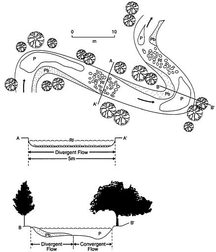
FIGURE 5.1 Idealized natural channel prototype: P, pool; Rf, riffle; Pb, point bar. Source: Reprinted by permission from Brookes, 1988. Copyright © 1988 by John Wiley & Sons, Ltd.
and longitudinal (upstream-downstream) dimensions, and this too can be patchy (Amoros et al., 1987). The area below the bed of the river is known as the hyporheic zone and may have temporary residents (salmon eggs and larvae), as well as permanent residents adapted to life in the interstices between the substrate particles. In many intermittent streams, life retreats to the hyporheic zone when surface flow ceases or when floods threaten to wash organisms out of the water column. The hyporheic zone may extend many stream widths to either side of the channel. Factors such as dissolved oxygen levels,
temperature, and interstitial flow rates may vary greatly among patches within the zone.
Modifications such as flow regulation and channelization make the stream environment more uniform, and restoration necessarily involves maintenance or recreation of the original patchiness.
Resistance and Resilience
Stream communities may be more resistant to certain types of disturbance and may recover more quickly from disturbance than lentic communities because they are adapted to a dynamic environment. A record flood may destroy property but have little effect on species that are adapted to flooding; access to the greatly expanded habitat
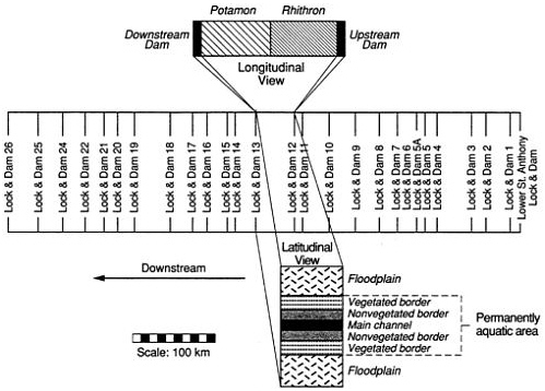
FIGURE 5.2 Longitudinal and latitudinal structure of the Upper Mississippi River. The latitudinal scale is purely schematic and greatly exaggerated relative to the longitudinal scale. The actual width of the river varies from about 500 m (at rocky narrows) to 5 km (including flooded areas). The channel width is also exaggerated: the main channel typically occupies only 3 percent of the floodplain system, or about 6 percent of the total width of the unleveed parts of the river. Source: Sparks et al., 1990.
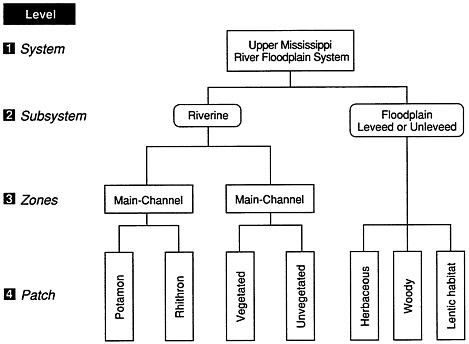
FIGURE 5.3 Hypothesized hierarchical structure of the Upper Mississippi River System floodplain. Source: Reprinted by permission from the Center for Aquatic Ecology. Copyright © by the Illinois History Survey, Champaign, III.
created by the flood probably benefits some species, such as floodplain spawners, without doing any permanent damage to other species, such as trees that are capable of surviving temporary inundation.
The hierarchical and patchy structure of streams also contributes to resistance and resilience (ability to recover). Organisms may recolonize a denuded reach from undisturbed upstream and downstream reaches or from tributaries, or they may avoid or survive a disturbance in the main channel by seeking refuge in hyporheic or lateral zones.
THE RIVERINE-RIPARIAN ECOSYSTEM
Integrative Concepts
Various attributes of rivers and streams described above are intergral to a discussion of the structure and function of riverine ecosystems (see Table 6.1 for connection with wetland functions). Foremost among these integrative concepts is the idea that rivers and their floodplains are so intimately linked that they should be understood,
managed, and restored as integral parts of a single ecosystem. The term "riverine-riparian ecosystem" has been applied by Jensen and Platts (1989) to streams and small rivers (those less than 2 m deep), and the term "river-floodplain system" to large rivers by Sparks et al. (1990) and Junk et al. (1989). To avoid repeating both terms throughout the text, the committee defines the term riverine-riparian ecosystem (RRE) as including both small and large systems. To avoid confusion, the committee will use the term stream-riparian ecosystem for small systems in which floods are so brief and unpredictable that aquatic organisms have not evolved adaptations for exploiting the riparian zone. The term river-floodplain ecosystem is reserved for systems with a predictable, long-lasting flood pulse that is exploited by fish and other aquatic organisms (see Figure 5.3).
The distinction between small and large systems is important because the riparian zone often functions as the donor of nutrients, water, and sediment, and riparian vegetation as a regulator of light and temperature for the recipient stream channel, whereas these functional roles are usually reversed in river-floodplain systems (Swanson and Sparks, 1990). In the larger ecosystem, the channel is usually the donor of water, sediment, and inorganic nutrients to the recipient floodplain, and light penetration and temperature in the inundated floodplain are often influenced by the influx of turbid, cooler channel water. In a stream, almost all the aquatic productivity is concentrated in the channel because the riparian zone is inundated only briefly. In contrast, most of the aquatic productivity in large river-floodplain ecosystems occurs in the floodplain because of (1) the predictable timing and relatively long duration of the annual flood pulse, and (2) the much greater area and volume of the floodplain in comparison to those of the channel (Junk et al., 1989). The channel of a large alluvial river is usually only a fraction of the total area that is seasonally inundated, and the productivity per unit area of the channel may be low because of low light penetration (due to turbidity and depth), high inorganic sediment concentration, and a shifting substrate.
Each riverine-riparian ecosystem contains a riverine subsystem and a riparian subsystem. The riparian subsystem is periodically inundated and is transitional between an aquatic environment and an upland environment (Jensen and Platts, 1989; Junk et al., 1989). The riverine subsystem is composed of the aquatic habitats within the channels. A single RRE occupies a drainage basin.
Jensen and Platts (1989) summarize the arguments for an approach to river restoration that treats the river and its floodplain or the stream and its riparian zone as parts of one ecosystem:
The values of riverine and riparian ecosystems are interdependent. Both riverine and riparian ecosystems are essential elements of fish and wildlife habitat; the riparian ecosystem serves to store and desynchronize peak flow conveyed by the riverine ecosystem; the food chain and nutrient cycling of both ecosystems are intertwined; the cultural and heritage values of riverine and riparian ecosystems are intimately linked.
Riverine and riparian ecosystems also function in an integrated fashion. Impoundment, channelization, and diversion in the riverine system can influence the hydrologic qualities of the riparian ecosystem. Similarly, impacts to the riparian ecosystem such as livestock grazing can cause erosion of streambanks and enlargement of channels, thus influencing the functional qualities of the riverine ecosystem. Since the values and function are interdependent, the approach for restoration of riverine and riparian ecosystems must be integrated.
The above discussion of streams and rivers should not be taken to mean that there is a definable boundary in the RRE, upstream of which is a stream and below which is a river; rather, each RRE is continuous from headwater to oceanic or basin sink. The biological structure and function of the RRE vary in a predictable way along a continuum, in response to variations in physical characteristics (Vannote et al., 1980; Wiley et al., 1990).
Discontinuities (i.e., disruptions in the predictable upstream-downstream patterns), are created when rivers are dammed. A dam may make conditions more like those of the headwaters (an upstream shift), or more like those downstream, or it may have a negligible effect, according to the serial discontinuity concept of Ward and Stanford (1983) (Figure 5.4). In cases where multiple dams create multiple discontinuities in the expected or natural pattern, individual dams could be redesigned and operated to restore some of the conditions (water temperature and dissolved oxygen) that formerly existed at that point in the river (e.g., by releasing epilimnetic water from the upstream reservoir, instead of hypolimnetic water), or a community more suited to the new conditions could be established by stocking. The first option is restoration; the second is creation of a community different from what was there originally, but somewhat representative of another portion of the RRE continuum. The created community may be different from the headwater community because the headwater organisms have other requirements that are not so easily met as those for temperature and oxygen: the quantity and quality fo food generated in the reservoir are different from those in the headwaters, and the dam may be a physical barrier to migratory species.
These continuum-discontinuity concepts have important implications for prioritizing and evaluating restoration projects. Restoration goals and the evaluation of success must take into account relative position along the continuum. This is especially true when using various biotic indices such as species diversity are used. Because the number of species of fish tends to increase downstream and the number of species of aquatic insects increases upstream, it would be inappropriate to expect a restored reach to have the same diversity as reaches located at different points on the continuum. It would be more appropriate to find a reference reach in an adjacent tributary of the same stream order.
The need for reference streams of the same order, against which the success of a restoration can be gauged, raises the complicating issue of regional variation among ecosystems. Although the general idea of an RRE as a continuum is correct, the river continuum concept of Vannote et al. (1980) best describes the type of RRE in which these ideas were first developed: stream-riparian ecosystems that originate in mountainous, forested watersheds of the temperate zone. Other regions differ in physical, chemical, and biological attributes, and the streams draining these different regions would be expected to have different properties (Wiley et al., 1990). Moreover, one RRE can pass through several different regions.
Ecoregions as Applied to Rivers and Streams
Omernik (1987) developed a map that divided the conterminous United States into 76 ecoregions based on regional patterns in land surface form, soil, potential natural vegetation, and general land use (see Figure 4.2). Hughes et al. (1990) evaluated the utility of these ecoregions in accounting for differences in fish communities in relatively undisturbed reference reaches of streams and river (1) in statewide case studies in Arkansas, Ohio, and Oregon (Larsen et al., 1986; Rohm et al., 1987; Whittier et al., 1987) and in three separate basin studies in Montana, Ohio, and Oregon (Hughes, 1985; Ohio EPA, 1987); and (2) in unpublished data on the Calapooia River in Oregon from Giattina (U.S. EPA, Chicago). Two analytical techniques were used to evaluate the similarity of the fish communities: detrended correspondence analysis (Gauch, 1982) and the index of biotic integrity (Karr et al., 1986).
Hughes et al. (1990) found that (1) the fish communities did demonstrate ecoregional patterns; (2) ecoregions that differed greatly in landscape attributes supported very different communities; (3) similar ecoregions supported similar communities; and (4) within-region
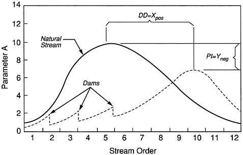
FIGURE 5.4 Theoretical framework for conceptualizing the influence of impoundment on ecological parameters in a river system. Discontinuity distance (DD) is the downstream (positive) or upstream (negative) shift of a parameter for a given distance (X) due to stream regulation. PI is a measure of the difference in the parameter intensity attributed to stream regulation. Source: Reprinted by permission from Ward and Stanford, 1983.
variation was less than among-region variation. The use of reference sites within ecoregions thus appears to be a useful way of establishing criteria for restoration and recovery of RREs. This approach is better than an oversimplistic approach of establishing national standards, which would be unachievable because of natural constraints in some regions and would not recognize the full restoration potential of others. At the same time, using criteria based on reference sites is not as costly as developing site-specific criteria—an impossible task in many cases, where predisturbance conditions are not known.
The natural structural and functional patterns of river-riparian ecosystems are disrupted by a variety of stresses, which are described next.
STRESSES ON RIVERS AND STREAMS
Stresses on the biotic components of river and stream ecosystems arise from (1) changes in the quality, quantity, and seasonal availability
of food for organisms; (2) deterioration of water quality, including temperature changes and excessive turbidity and sediment; (3) modifications of the habitat, including the substrate; (4) water quantity or flow mistiming; and (5) biotic interactions (Figure 5.5; Karr et al., 1986). The locus of the problem can be in the watershed, along the riparian or floodplain zone, or in the channels and pools (see Tables 5.1 and 5.2).
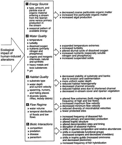
FIGURE 5.5 Five major classes of environmental factors that affect aquatic biota. Arrows indicate the effects that can be expected from human activities, in this case the alteration of headwater streams, excluding small impoundments. Source: Reprinted by permission from Karr et al., 1986. Copyright © by the Illinois Natural History Survey, Champaign, III.
TABLE 5.1 Causes of Stream and River Degradation
|
Dams (hydroelectric, water supply, and navigational aids [locks]) |
|
Dredging |
|
Erosion |
|
Filling |
|
Grazing in riparian zone |
|
Industrial point source discharges |
|
Logging |
|
Mining |
|
Municipal point source discharges |
|
Overfishing |
|
Road construction |
|
Urban, suburban, and agricultural nonpoint source runoff |
TABLE 5.2 Types of Stream and River Problems
|
Bank Erosion |
|
Blockage of main channel or cool tributaries |
|
Braided channel |
|
Dissolved oxygen deficiency |
|
Excessive flooding |
|
Food scarcity for biota |
|
Genetic deterioration of fish stocks |
|
Gravel unavailable or sediment-covered |
|
Invertebrate deficit |
|
Nutrient loss |
|
Pool deficit |
|
Pool spawning success |
|
Sediment loss |
|
Shelter deficit (for fish resting and refuge) |
|
Siltation |
|
Species (extinct, endangered, threatened) |
|
Stream cover (deficit or overgrown) |
|
Water quality (turbidity and chemical pollutiona) |
|
Water release mistiming |
|
Water supply deficit (from water withdrawals or drought) |
|
Water temperature (too high or too low) |
|
Water velocity (too high or too low) |
|
(a) Includes supersaturation with nitrogen from water passage through hydroelectric facilities (Narver, n.d.). |
Point Sources of Pollution
Human activities have had major impacts on streams and rivers. Discharges from population centers and industries are point (end-of-pipe) sources of pollution, whereas human uses of drainage basins
(agriculture and silviculture) can cause nonpoint pollution. At first, municipal and industrial wastes simply drained into the nearest watercourse. Later, as populations grew and there were outbreaks of waterborne disease, waste was collected in sewers and diverted away from water intakes. In Chicago, for example (Appendix A), waste was diverted away from Lake Michigan and into the Illinois River, starting on a large scale in 1900. Eventually the assimilative capacity for waste of even the largest rivers was exceeded, and waste treatment plants had to be constructed. Substantial federal assistance for sewage plant construction and upgrading was provided by the Federal Water Pollution Control Act of 1972, and by subsequent legislation, including the landmark Clean Water Act of 1977.
The approach to restoring water quality was to develop criteria for various uses of water and then design waste treatment plants that would achieve effluent standards that in turn would protect or restore the beneficial uses of the stream or river, including fish and wildlife production and use for public water supply. In general, this approach has worked to a substantial degree for conventional pollutants, including oxygen-demanding organic waste, as indicated in the examples of the Illinois and Merrimack rivers, the biennial water quality reports issued by the states under requirements of Section 305 (b) of the Clean Water Act (e.g., Illinois EPA, 1990; ORSANCO, 1990) and national water quality summaries (CEQ, 1989; Smith et al., 1987). However, point and nonpoint discharges of toxicants remain a problem; and a legacy of pollutants, including toxicants, remains in sediments and can enter food chains. For example, public health advisories against consumption of certain nonsport fish in the Ohio River were issued by Pennsylvania, Ohio, West Virginia, and Kentucky in 1987 and 1988 because of high levels of chlordane or polychlorinated biphenyls (PCBs; ORSANCO, 1990; see also Merrimack River and Willamette River case studies, Appendix A).
Nonpoint Sources of Pollution
River-riparian systems are products of how their drainages are covered (vegetation type) and how the land is used (grazed, cropped, or urbanized). Over the past 30 years (1960s through 1980s), major land use categories have changed very little (Flather and Hoekstra, 1989). There has been a slight reduction in rangeland and forest (5 percent each) and a 3 percent increase in cropland. There are regional differences: in the Southeast, forest land has increased substantially. Urban land increased 88 percent, from approximately 25 million acres in 1960 to 47 million acres in 1980 (Flather and Hoekstra,
1989). The net result of these changes has been a reduction in land that tends to support natural vegetation (forests and rangeland) and an increase in land heavily modified for human use (cropland and urban land). Although croplands and urban lands probably release more pollutants per acre on average than forests and rangeland, practices such as clear-cutting, fall plowing, and grazing can increase pollution loading of streams and rivers. McElroy et al. (1975) determined that 97 percent of the land in the United States is rural and that all of it is a potential source of nonpoint pollution, including sediment, animal waste, nutrients, and pesticides; 64 percent is used for agriculture or silviculture and only 0.6 percent for mining and construction (Table 5.3).
Nutrients and toxicants may be dissolved in water or may ride sediment particles into streams where these materials can wash downstream, accumulate in depositional areas, be ingested by organisms, or be released to the water. Sediments rich in organic matter may release toxic ammonia and hydrogen sulfide, and create low levels of dissolved oxygen in overlying water due to decompositional processes.
According to the Association of State and Interstate Water Pollution Control Administrators (1984), 11 percent of the total river miles in the United States was ranked as having moderately to severely impaired use because of nonpoint sources of pollution. The nonpont sources and their percentage contribution to total impacted river miles included agriculture (64 percent), mining (9 percent), silviculture (6 percent), urban runoff (5 percent), hydromodification (4 percent), construction (2 percent), and land disposal (1 percent). The
TABLE 5.3 Land Use in the United States
|
Land Use Category |
Percent |
Millions of Hectares |
|
Farmland in grass |
36 |
218 |
|
Cropland, plus farmsteads and roads |
28 |
167 |
|
Construction (annual) |
<1 |
0.59 |
|
Commercial forest (includes farm woodlands and forests) |
34 |
202 |
|
Annual harvest of forests (growing stock) |
<1 |
4.45 |
|
Subsurface mines |
<1 |
2.8 |
|
Surface mines |
<1 |
1.2 |
|
Active surface mines |
<1 |
0.14 |
|
Mineral waste storage |
<1 |
1.2 |
|
Total |
100 |
597.38 |
|
Source: Modified from McElroy et al., 1975. |
||
major problem was sediment, which accounted for 47 percent of the nonpoint source pollutants in affected river waters.
Practices associated with forestry and farming not only increase the introduction of pollutants into streams, but also alter the physical structure and function of river-riparian ecosystems, as discussed in the sections below on overgrazing and on drainage and channelization.
Overgrazing
The American Fisheries Society recently issued a position statement on the effects of livestock grazing on riparian and stream ecosystems (Armour et al., 1991) from which this summary is largely taken. Overgrazing of livestock in riparian areas is a major problem. Grazing is permitted on 91 percent of the federal land in the 11 contiguous western states, where federal land constitutes 48 percent of the total land area. Thirty-two percent of the land is private rangeland. The best information on the relationship between grazing and stream degradation apparently is available for land administered by the Bureau of Land Management (BLM), but the trends are probably similar for Forest Service and private lands. Fifty-eight percent of the 150 million acres of BLM rangeland is in fair to poor condition, and 19,000 miles of sport fishing streams, 100 million acres of small game and nongame habitat, and 52 million acres of big game habitat have declined in quality as a result of land use practices, including overgrazing.
Armour et al. (1991) point out that because riparian environments are lumped into much broader terrestrial classifications (e.g., ''rangeland," as in McElroy et al., 1975, classification), they become unidentifiable for land management purposes, and the problem is probably worse than the above figures indicate. For example, rangeland that is in fair to poor condition probably has river-riparian ecosystems that are in much worse condition because livestock (and wildlife) spend much more time and graze more heavily in the well-watered riparian area.
Overgrazing by livestock can eliminate streamside vegetation directly, or indirectly as a result of caving and trampling of banks, which can lead to channel widening, channel aggradation, lowering of the water table, and decline in water quality downstream because of turbidity, sedimentation, and animal waste. The water may become too turbid, warm, and shallow and the substrate too choked with fine sediment to support native fish and their food base.
Overgrazing on federal land might be reduced if it were not subsidized. The General Accounting Office (U.S. GAO, 1988) reported that the BLM recovered only about 37 percent of the cost of providing grazing on federal land and that the Forest Service recovered only
30 percent. Also, neither agency had current information on range conditions, and only about half the grazing allotments had been evaluated in the last 10 years.
Increasing the fees on federal grazing land would remove the incentive for overgrazing that current low fees provide. Increased fees might help to improve the management and administration of the federal grazing system.
Drainage and Channelization
A U.S. Fish and Wildlife Service manual on stream channelization impacts (Simpson et al., 1982) estimated that as much as 70 percent of the overall riparian habitat associated with streams in the continental United States had been lost or altered and that much of this loss was associated with channelization activities. Unfortunately, there is no reference for the 70 percent figure nor any explanation of how it might have been derived, other than the following discussion, taken from the report. There is little information available on the extent of early (1800s) channelization activities of the U.S. Army Corps of Engineers (COE), but between 1940 and 1971, COE assisted in 889 stream projects totaling 11,077 miles of stream. The Soil Conservation Service (SCS) was involved in the channelization of 21,401 miles as of 1979. The U.S. Department of Agriculture estimated that 189,000 miles of open ditches had been constructed for drainage of agricultural lands by 1959. Bhutani et al. (1975) estimated that channelization and drainage for agriculture would average 6,600 miles per year through 1985. Arthur D. Little (1973) estimated that more than 200,000 miles of stream channel had been modified in the United States by 1972. If streams and rivers in the United States total approximately 3.2 million miles in length (Echeverria et al., 1989), 200,000 miles is approximately 6 percent of the total-quite different from 70 percent! A few states have assessed the extent of channelization. Lopinot (1972) reported that 26.8 percent, or 3,123 miles, of the interior streams in Illinois (excluding the Mississippi, Ohio, and Wabash rivers) had been channelized; this also is a much lower value than the 70 percent average estimated by Simpson et al. (1982), despite the fact that Illinois is a corn belt state where much of the original marshy prairie had to be tiled, ditched, and drained to make it suitable for agriculture. It is clear that an inventory of the nation's streams and rivers is needed, so that their condition can be assessed. This inventory should be updated periodically to track progress in protecting and restoring streams.
Impacts of channelization on habitat for fish and invertebrates include
removal or subsequent loss of riparian vegetation, loss of instream cover (snags), altered riffle pool sequence, decreased stream sinuosity, altered substrate composition, increased stream velocity, increased bank erosion and bed scour, increased suspended sediment, and increased water temperature (Crandall et al., 1984).
Suspended Sediment
Sediments constitute 47 percent of the materials introduced from nonpoint sources (ASIWPCA, 1984). Particle size ranges from rocks, gravel, and sand to very fine silt. Large particles usually settle to the bottom fairly rapidly, but the fine silt remains suspended for long periods of time, producing turbidity. Because turbidity causes light to be scattered and absorbed rather than transmitted in a straight line, light penetration is reduced, in turn diminishing or even eliminating plant growth (Stern and Stickle, 1978).
When plant beds are eliminated, turbidity problems may worsen. Plant roots anchor the bottom against wave action and disturbance by bottom-feeding fish such as carp. The stems and leaves of floating and emergent plants dampen waves. Jackson and Starrett (1959) showed that wind had little effect on the turbidity of backwater lakes along the Illinois River when plants were present, but that there was a marked effect when vegetation was absent. The loss of aquatic macrophytes leads to the loss of associated "weed fauna" (i.e., the snails and aquatic insects that graze on the plants and in turn provide food for young fish). Smith (1971) indicates that populations of bigeye shiner (Notropis boops Gilbert), bigeye chub (Hybopsis amblops [Rafinesque]), and pugnose minnow (Notropis emiliae [Hay]) have been decimated in Illinois streams because of the disappearance of aquatic vegetation. Predatory fish do not depend directly on plants for their livelihood, but they do depend on good visibility for finding food (and fishermen's lures). Although fish are able to find food using alternate senses, such as the lateral line system, Vinyard and O'Brien (1976) found that turbidity can reduce the feeding of game fish even if there is an abundance of food in the water. However, in many cases food is not abundant because turbid waters also limit the production of zooplankton on which forage fish such as gizzard shad live. Buck (1956) found that the ratio of forage fish to predacious bass and crappie was approximately 1 to 1 in muddy water and 13 to 1 in clear water. He found that when so little food was available, there was only a small population of older, slow-growing bass with very low rates of reproduction. In clear water, he found large bass populations that were reproducing successfully. In addition to sight feeding, many
species of game fish exhibit complex reproductive and social behaviors that depend on visual cues. A reduction in visibility interferes with these visual cues and thereby reduces reproduction.
Fish can tolerate short episodes of high levels of suspended sediment, and some species in laboratory bioassays have survived mixtures that can be characterized as slurries of suspended clay particles (Wallen, 1951). Fish exude a protective mucus on their skin and gills that traps and continually flushes particles away. However, this protective mechanism requires metabolic energy and constitutes a stress on the fish at the same time as its ability to find food is reduced.
Other organisms also have similar protective mechanisms. Mussels have a protective mucus on their gills and can close their shells, but these are only temporary measures, and the defenses of mussels against excessive sediment are eventually overwhelmed by long periods of exposure. Because mussels are nonselective filter feeders, the food available to them in silt-laden waters is diluted by the presence of inorganic silt (Widdows et al., 1979), which is rejected as pseudofeces. Laboratory experiments with freshwater mussels kept in water having continuous very high loads of suspended sediment showed that silt interfered with their feeding, because the mussels stayed closed 75 to 95 percent of the time. Mussels dying in these experiments always contained deposits of silt in the mantle cavity and frequently in the gill chambers (Ellis, 1936). The yellow sand-shell (Lampsilis anondontoides), a sand-inhabiting species, was most readily killed by silt deposits in Ellis's experiments and has also disappeared from the Illinois River, probably due to increased silt loads (Starrett, 1971). Recent studies have focused on the impact of intermittent exposure to high silt levels, such as might be found in navigable rivers. Payne et al. (1987) found that when freshwater mussels were exposed to intermittent high levels of suspended solids, feeding was disrupted and they shifted to catabolism of endogenous nonproteinaceous energy reserves.
Therefore, although some adult organisms can withstand enormous amounts of sediment in water for several days or weeks, a population may eventually die out due to starvation, reproductive failure, or cumulative stress (Illinois EPA, 1979). Thus, the long-term effect of chronic suspended sediment is to change the species composition of a body of water by changing the habitat and the food supply, and by bringing about differential rates of reproduction in different species.
Sediment Deposition
Diversity in the topography of the bottom of a stream or river is important in maintaining diversity of plant and animal life. In shallow
low areas with swift waters, gravel beds and riffles provide habitat and spawning areas for many creatures. Where currents are slower, submerged and emergent vegetation becomes established and provides food and shelter for a different group of aquatic animals. In very deep areas, there are holes in the vegetation because rooted plants cannot become established. The edges of these holes are often inhabited by desirable game fish that feed on the forage fish living among the plants.
When sediment deposition exceeds sediment transport, deposits of fine sediment can cover gravel bottoms that many organisms need for feeding and reproduction, and may fill the deep pools and cover the rocks and woody debris where game fish live and feed (Roseboom et al., 1983). Ellis (1936) showed that most of the common freshwater mussels were unable to maintain themselves in either sand or gravel bottoms when a layer of silt from 0.25 to 1 inch deep was allowed to accumulate on the surface of otherwise satisfactory bottom habitats. A study conducted in Idaho showed that when the fine sediment in spawning riffles exceeded 20 to 30 percent by volume, the survival of salmon embryos declined (Bjornn et al., 1977), and in Arizona, salmonid populations were found to be inversely proportional to the fine content of the bottom (Rinne and Medina, 1989). In a Michigan stream, brook trout (Salvelinus fontinalis [Mitchill]) populations were reduced by 50 percent when bed load was artificially increased by four to five times (Alexander and Hansen, 1986) and walleye (Stizostedion vitreum [Mitchill]) eggs were smothered by fine sediments in Minnesota (Johnson, 1961).
Fine sediments affect invertebrates, as well as fish eggs and larvae, in the hyporheic zone. The hyporheic zone serves as a refuge from predators and swift currents and as a feeding area for early instars. It also functions as a site for nutrient transformation (Stanford and Ward, 1988; Ward, 1989); all these functions are altered when fine sediments fill the interstices between coarser bed particles.
In slow-moving waters, fine sediment deposition may continue unchecked until the bottom becomes so soft and unstable that rooted plants can no longer gain a foothold. Because the deepest holes fill fastest, the end result is a leveling out of the bottom topography and a loss of fish habitat. In extreme cases, sediment can completely fill, and thereby destroy, an aquatic habitat (see Illinois River case study, Appendix A).
In some cases, sediment deposition may create new habitat. Dammed rivers, especially those that carry heavy sediment loads, begin depositing sediment as soon as the dam is completed. As the bottom behind the dam slowly rises, it enters the euphotic zone (i.e., the depth
at which sufficient light penetrates to enable plants to grow). The sediments in southern and midwestern rivers that drain agricultural areas serve as sinks for nutrients, particularly phosphorus, which nourishes the new plants once there is sufficient light. In the Mississippi River, for example, extensive new plant beds are located near Montrose, Iowa, just upstream of Lock and Dam 19 (Sparks et al., 1990). In the long-term view, however, these plant beds are only temporary because they will continue to collect sediment until they become higher than mean water level, at which time they will begin providing habitat for terrestrial creatures.
Much of the prime agricultural land in the Midwest and the South is located on alluvial floodplains that developed over thousands of years and supported bottomland hardwood forests. Before the forests were removed, the floodplains served as sedimentation basins and nutrient sinks. Wilkin and Hebel (1982) found that sediment settled in forested floodplains and forested stream borders at the rate of 10 to 20 tons per acre per year. Where the floodplain had been cleared for row crops, sediment was being eroded from the floodplain at a rate of 15 to 60 tons per year. In an agricultural watershed, stream-bank erosion and resuspension of sediment contributed the major portion of annual stream yields of sediment (Sharpley and Syers, 1979). These sediments carry with them the nutrients that make the floodplains desirable for agriculture. By chemically analyzing eroding stream bank soils, Roseboom (1987) determined that bank erosion yielded approximately half of the total phosphate, ammonia, and nitrogen in a channelized floodplain stream in central Illinois.
Once it has returned to the water, sediment can serve as either a source or a sink for nutrients, depending on conditions such as pH, temperature, oxidation-reduction potential, and the amount of nutrients present in the water. For example, phosphorus in the water and phosphorus carried into the water on sediments will come into equilibrium. If plants take up the phosphorus in the water, the sediment can supply more. If there is an excess of dissolved phosphorus, the sediment will take it up (Illinois EPA, 1979); Froelich, 1988). Ammonia supplies nitrogen, another nutrient for aquatic plants; however, it constitutes a greater problem than phosphorus because it is toxic to fish and other animals (Roseboom and Richey, 1977; Thurston et al., 1981).
In extremely turbid waters the presence of these nutrients may not be evident because light is insufficient for plant growth. However, should turbidity be somewhat reduced either by natural processes such as low flow or by reductions in the amount of sediment being
introduced, allowing more light to penetrate, algal blooms may occur. Thus, as the Illinois Environmental Protection Agency has pointed out, removing sediments may not be sufficient to ensure high aesthetic enjoyment of water if the nutrients remain in a dissolved state or in sediments on the bottom (Illinois EPA, 1979).
In addition to nutrients, a number of toxic substances are adsorbed on soil particles that move into streams. Among them are metals such as copper, zinc, and lead,d which are known to accumulate in sediment. Mathis and Cummings (1973) found that most metals in the Illinois River occurred in sediments at levels several orders of magnitude greater than the levels in water. Organisms that live in the sediment, such as oligochaete worms and clams, contained higher levels of the metals than did organisms such as fish. Because the chemical environment in the gut of a worm or at the gill surface of a clam is different from that in the sediment or water, it is possible that metals and other toxicants can be mobilized from the sediment and taken up by organisms that ingest sediment or live in contract with it.
Pesticides constitute another group of chemicals that can be taken up by organisms. When pesticides are introduced into an aquatic ecosystem they are stored in the bodies of organisms, where biological amplification may take place as the chemicals move through the food web. Although modern pesticides are formulated to degrade, some of the degradation products are not entirely harmless. Also, much agricultural land still contains persistent pesticides or their metabolites from earlier years (Illinois EPA, 1979). Degradation may take days or weeks, and in the meantime pesticides remain deadly to nontarget species as well as those that were targeted. Every year, fish skills caused by agricultural chemicals are reported either to insurance companies or to the EPA. The two most common causes of these fish kills are runoff of insecticides from freshly sprayed fields. usually when spraying is closely followed by heavy rains, and carelessness on the part of applicators who allow leftover chemicals to drip from their tanks (Illinois EPA, 1979).
Eroded silt also often carries with it organic matter that creates an oxygen demand in the water. Ellis (1936) found that the oxygen demand of organic matter mixed with silt lasted 10 to 15 times as long as the oxygen demand created by the same amount of organic matter mixed with sand.
Butts (1974) found that oxygen demand can increase dramatically when sediment containing organic material and bacteria is resuspended by waves or currents. In the Peoria Pool of the Illinois River, for example, he found that under quiescent conditions the sediment oxygen demand was 2.8 g/m2 per day, but that the demand rose to 20.7
g/m2 per day when the sediments were disturbed. In some reaches of the river the oxygen demand exerted by sediment was great enough to seriously diminish the oxygen supply in the water, endangering aquatic animals.
Dams
Dams have been placed on every type and size of flowing water, from intermittent headwater streams to the Mississippi River. Croome et al. (1976) suggested that by the year 2000, approximately 66 percent of the world's total stream flow will be controlled by dams. Mermel (1976) used information from the World Register of Dams (International Commission on Large Dams, 1973) to conclude that dams are being built on the world's rivers at an average rate of 2 per day. In North America, more than 200 major dams were completed each year between 1962 and 1968 (Beaumont, 1978). The rate of construction of nonfederal dams, which are presumably smaller than the major dams counted by Beaumont, decreased from more than 2,000 per year in the 1960s to about 1,240 per year during the 1970s, according to the 1982 inventory of nonfederal dams conducted by the U.S. Army Corps of Engineers (Johnston Associates, 1989).
Aside from the obvious effects of changing flowing water to standing water, altering downstream flow patterns of both water and sediment, and blocking migrations of aquatic organisms, dams alter water quality and initiate long-term changes in downstream channels, riparian zones, and floodplains. Release of cold, deoxygenated water from the depths of reservoirs adversely affects native stream organisms adapted to warmer, aerated water (NCR, 1987). Flow regulation by dams reduced the area of floodplain wetlands by 67 percent in a 145-km sample reach of the Missouri River (Whitley and Campbell, 1974). Further reductions occurred in other parts of the Missouri when side channels, pools, and wetlands that once supported fish and wildlife were left high and dry after the channel was down-cut. Down-cutting was attributable to an increase in the erosive power of the middle Missouri River following storage of sediment in the reservoirs of the upper river (Hesse et al., 1982).
Dams may have an effect on quite distant ecosystems. Closure of the major dams on the upper Missouri River was followed by a step decrease in the sediment load measured on the lower Mississippi at Tarbert Landing, Mississippi, and Simmesport, Louisiana, because the dams trapped sediments (Keown et al., 1981). Hence less sediment is now available for maintaining the Mississippi Delta against coastal erosion and subsidence (Penland and Boyd, 1985). A famous well-documented
example (although not located in North America) is the loss of a Mediterranean fishery due to the construction of the Aswan Dam in Egypt. A nursery ground for species of Mediterranean fish had existed behind a sandbar at the mouth of the Nile that paralleled the coast. The loss of particulate material due to currents in the Mediterranean was compensated for by the addition of new sedimentary material from the Nile. When this renewal ceased, the sandbar eroded and the nursery ground was seriously affected (George, 1972).
Alteration of Flow Patterns
Annual flow patterns have been altered not only by dams, but also by diversions, consumptive uses (irrigation, evaporative cooling), and acceleration of runoff in drainage basins. In urban and suburban areas, rain falls on impervious surfaces and is directed into the nearest watercourse via storm sewers. In agricultural areas, drain tiles, ditches, and channelized streams have the same effect. Water drains much more rapidly from logged areas than from the original forest. The end result of these land uses is that flood peaks are higher, and low stages are lower and longer lasting, than in the past because there is less retention of water in the basin itself (Borman et al., 1969; Karr and Dudley, 1981; Herricks and Osborne, 1985). Changes in the flow pattern often trigger unwanted changes in deposition and erosion. Sediments may accumulate in formerly productive channels and backwaters downstream, or a process of headward erosion can begin. During droughts, there may be too little base flow in these modified streams to support aquatic life and other beneficial downstream uses.
Modifications in floodplains, as well as on the upland drainage, have altered flow patterns. Flood protection levees permit the former floodplain to be used for agriculture, industry, or housing, but it is no longer available for fish and wildlife production, production of hardwood timber, recreation, or the storage and conveyance of floods. It is ironic that these levees actually increase flood heights (Belt, 1975). Sedimentation rates increase on the remaining unleveed floodplains to the point that the native vegetation, including valuable hardwoods, may be smothered.
Boat Traffic
Rasmussen (1983) summarized the stresses created by navigation projects and the boat traffic they support. Stresses associated with navigation dams are similar to those described above. Building canals
and locks around natural barriers sometimes leads to unwanted introduction of species (the classic example is the invasion of the Great Lakes by the sea lamprey after Niagara Falls was bypassed by the St. Lawrence Seaway). Wing dams are dikes, perpendicular to the shore, that confine the main flow, thus creating a stable channel that tends to maintain adequate depht for navigation by scouring. Sedimentation occurs between the dikes, filling in the productive channel borders. Closing dams across side channels have the same engineering function and the same side effects as wing dams.
Water displacement, propeller wash, and wakes from boats resuspend bottom sediments, increase bank erosion, and can disorient or injure sensitive aquatic species. Aquatic organisms may also be struck by hulls or propellers. Finally, waste discharges and accidental spills from boats or loading facilities can introduce pollutants and exotic species.
Acid
Conducted between 1984 and 1986, the national surface water survey (NSWS) was one of the first activities undertaken by the National Acid Precipitation Assessment Program (NAPAP, 1990).
From a target population of 59,000 stream reaches (211,000 km), overall only 8 percent, or 4,520 reaches (7,900 km), were found to be acidic. Proportions ranged from less than 1 percent in the western United States and southeastern highlands to 39 percent in Florida, but in all other NSWS regions, 12 percent of fewer of the streams were acidic. The major causes of acid streams are acid deposition, acid mine drainage (Box 5.4), and naturally occurring organic acids.
In 47 percent of the chronically acid streams, the dominant acid anions derived from deposition (via acid rain, acid snow, acid fog). In the majority of these streams, sulfate concentrations exceeded base cation concentrations, indicating that the acidic conditions were caused by sulfuric acid. The most likely explanation for the loss of brook trout populations in the Adirondacks is recent acidification caused by high inputs of atmospheric sulfate (NAPAP, 1990).
In 27 percent of the acid streams, organic acids are the main source of acid ions. These streams are located in Florida and the Mid-Atlantic Coastal Plain and are associated with wetlands or organic soils. In Florida, healthy largemouth bass populations are found in waters with pH ranging from 4.0 to 4.5, and there do not appear to be significant population losses. In contrast, the Mid-Atlantic Coastal Plain has experienced a continuing decline of anadromous species since the 1970s. Some streams whose acidity was formerly caused by organic
|
BOX 5.4 Acid Mine Drainage The United States has a backlog of almost 50 billion tons of old mining and mineral processing wastes (Kleinmann and Hedin, 1990). Therefore it is not surprising that more than 12,000 miles of rivers and streams and 180,000 acres of lakes and reservoirs are adversely affected by mining in the United States (Kleinmann and Hedin, 1990). Acid mine drainage—a fluid generally 20 to 300 times as acidic as acid rain—is responsible for at least a third of this ecological damage (Kleinmann and Hedin, 1990). In sufficient concentrations, acid mine drainage (AMD) coats stream bottoms with a rust-colored iron precipitate, adds enough sulfuric acid to acidify the water, and kills aquatic life (Kleinmann and Hedin, 1990). Formed from the oxidation of iron pyrite, AMD is associated with coal mining in the eastern United States and with metal mining in the West. In the past 20 years, the number of rivers and streams adversely affected by AMD has reportedly dropped by about a third, primarily due to perpetual chemical neutralization of mine water before discharge (an expensive process) and by reclamation of abandoned mines (Kleinmann and Hedin, 1990). Some of the improvement, however, has come from natural amelioration by gradual oxidation of the iron pyrite and some by intentional flooding of deep mines to prevent the pyrite from oxidizing. Still other improvements have been gained by construction of cattail wetlands to purify mine wastewater, usually by bacterial action; more than 400 such wetlands have been constructed in recent years (Kleinmann and Hedin, 1990). Anionic surfactants are also used to inhibit iron-oxidizing bacteria in mine waste piles. Another technique to control AMD caused by fractured streambeds that leak into underground mines is to seal the streambeds by injecting them with polyurethane grout beneath the sediment-water interface to minimize pyrite-water contact. |
acids have undergone a change in chemical dominance from organic acidity to mixed acid sources, and bioassays indicate that a majority of these streams may be toxic to larval anadromous fish. However, there are so many other contributing factors that it is not possible to link these declines directly to acidification.
Twenty-six percent of the acid streams are the result of acid mine
drainage and contain concentrations of sulfate, base cation, iron, and aluminum that are much higher than those found in streams dominated by acid deposition. These streams are found mainly in the Mid-Atlantic Highlands, where 60 percent of the acidic stream length is due to acid mine drainage. Although some relatively low-pH streams contain brook trout, their absence from streams with higher pH may indicate that short-lived acidic episodes can determine the composition of fish communities in some regions.
The effects of low pH on aquatic life are difficult to separate from the effects of other pollutants, physical habitat changes, and changes in stocking patterns that may be occurring simultaneously. Also difficult to sort out are the relative contributions of the various sources of acid anions. It appears, for example, that in some streams, shifts may be occurring in the sources of acidity and the relative proportions of organic and inorganic ions (e.g., streams that formerly derived their acidity from naturally occurring organic acids are becoming more acidic due to deposition of atmospheric sulfate).
Fishing
Sport fish populations appear to be more threatened by habitat loss and pollution than by overharvesting. However, overfishing is a concern in 7 percent of the nation's streams (Flather and Hoekstra, 1989), and Narver (n.d.) includes species reintroduction as one of the nonstructural techniques of river and stream restoration (Tables 5.4 and 5.5). Projections made by Flather and Hoekstra (1989) indicate that as the U.S. population increases, the number of people participating in both cold-and warmwater fishing will increase. An increasing human population implies a further reduction in habitat, resulting in fewer fish per angler. Restricting use of the resource is one way to protect it, but local governments are reluctant to reduce recreational opportunities, and even though state and local governments monitor the population and regulate the catch of important species, there is no way to calculate the illegal harvest. Anecdotal evidence hints at widespread violations of size and creel limits, and a lack of law enforcement (Burgess, 1985). If this is the case, then further regulation may only intensify the illegal fishing pressure.
Releasing hatchery-raised fish is the approach most often used to maintain fishing in many areas that otherwise would not have a sustainable sport fish population. These releases may in themselves constitute a stress when nonlocally adapted strains of fish are released with no understanding of their potential effect on native populations. Highly inbred hatchery stocks may be successfully adapted
TABLE 5.4 Techniques Used in Stream and River Restoration
|
Structural Methods |
Nonstructural Methods |
|
Bank armoring |
Flow regulation |
|
Bank overhangs (covers) |
Plantings |
|
Brush bundles |
Trees |
|
Brush removal |
Brush |
|
Channel reconstruction |
Herbaceous vegetation |
|
Dams |
Grass |
|
Dechannelization |
Pollution abatement |
|
Deflectors |
Propagation facilities |
|
Fencing |
Incubation |
|
Fish passageways |
Spawning |
|
Fish screens |
Land acquisition |
|
Gabions |
Land use regulation |
|
Half-logsa |
Species reintroduction |
|
Log drop structure |
|
|
Meanders |
|
|
Riprap |
|
|
Rock placement (individual)b |
|
|
Root wadc |
|
|
Sediment basinsd |
|
|
Snag placement |
|
|
Stream clearance (to remove obstructions) |
|
|
Substrate placement |
|
|
Trash catchers |
|
|
Tree revetemente |
|
|
Weirs |
|
|
a Split logs are anchored in the streambed, parallel to the current, with space underneath for salmonids to hide and rest. b Individual rocks are placed in the stream channel to focus the current to protect banks or to provide refuge for fish. c Root wads may be anchored into the stream channel to generate eddy currents for creation of small pools (U.S. FWS, 1984); root wads may also be buried trunk first in reconstructed banks to absorb and dissipate flow energy (see Boxes 5.4 and 5.6 on the Blanco and San Juan rivers, respectively). d Wydoski and Duff (1980). e Tree trunks and branches are angled along banks into current to reduce water velocity (Roseboom and White, 1990). |
|
to a hatchery environment but may not be successful in the wild. Fish originating in different geographic areas may not be able to tolerate conditions, such as low winter temperature, that native stocks tolerate easily. If the introduced fish survive long enough to interbreed with native stocks, their maladaptive genes may not pose a problem until they face an environmental crisis such as an especially
TABLE 5.5 Major Categories of River and Stream Restoration
|
Bank stabilization |
|
Channel modification |
|
Dechannelization |
|
Fish reintroduction |
|
Flow (volume) augmentation |
|
Organic matter introduction (to increase invertebrate production)a |
|
Revegetation |
|
Regulation of land use in watershed |
|
Soil stabilization |
|
Water quality improvement |
|
Water temperature modification |
|
a Narver (n.d.). |
cold winter; then the entire population (Philipp and Whitt, 1991) and, more importantly, the locally adapted genotype are lost.
Many of the stresses that affect recreational fisheries will also affect commercial fisheries. Salmon populations are closely monitored, and there are already warnings that the salmon harvest is excessive and needs to be restricted to avoid depleting future stocks (Weber, 1986). If restrictions are implemented, it is likely that salmon prices will rise, but the incomes of fishers and of people employed in salmon-dependent businesses will decrease. When a resource such as the salmon fishery has both recreational and commercial value, advocacy groups arise promoting their particular use of the resource. Although sportsmen and commercial fishermen alike recognize that the fishery is a finite resource, allocating the resource appropriately is difficult, with outcomes often based on legalities rather than biological realities (Flather and Hoekstra, 1989).
FLUVIAL RESTORATION
Objectives
Previous sections described the structural and functional characteristics of healthy, undisturbed river-riparian ecosystems and the stresses that have degraded these systems. Here we define and describe the goals and objectives of fluvial restoration.
The goal of restoration is the return of an ecosystem to a close approximation of its condition prior to disturbance (Chapter 1). The essence of a fluvial ecosystem is the dynamic equilibrium of the physical system, which in turn establishes a dynamic equilibrium in the
biological components. Therefore, the goal of fluvial restoration should be to restore the river or stream to dynamic equilibrium, not to ''stabilize" a channel or bank. The objectives under this broad goal are as follows:
-
Restore the natural sediment and water regime. Regime refers to at least two time scales: the daily-to-seasonal variation in water and sediment loads, and the annual-to-decadal patterns of floods and droughts. In arid areas, some organisms depend on rather infrequent (occurring only every few years) and unpredictable flooding. Organisms in large floodplain rivers in tropical and temperate zones depend on highly predictable seasonal flooding.
-
Restore a natural channel geometry, if restoration of the water and sediment regime alone does not.
-
Restore the natural riparian plant community, which becomes a functioning part of the channel geometry and floodplain/riparian hydrology. This step is necessary only if the plant community does not restore itself upon achievement of objectives 1 and 2.
-
Restore native aquatic plants and animals, if they do not recolonize on their own.
Chapter 1 noted that all restorations are exercises in approximation, and fluvial restorations are no exception, given the economic value of water, water-control structures, and structures that are threatened by floods, erosion, and sedimentation. It is unlikely that natural sediment and water regimes, and naturally dynamic channels, can be or will be completely restored throughout the largest river systems of the United States. Benke (1990) found only 42 rivers in the contiguous United States that are more than 120 miles (200 km) long and free flowing. However, there are substantial segments of the Illinois River, Atchafalaya River, and Upper Mississippi River included in public lands (e.g., the Upper Mississippi River Fish and Wildlife Refuge) that do retain floodplains and a flood pulse. The objectives are to add to the existing river-floodplain segments and to restore or rehabilitate degraded segments (see appropriate case histories, Appendix A). In the Illinois and Upper Mississippi rivers, levees are left in place around lands being reclaimed from agriculture or mining for fish and wildlife refuges so that the new refuges are not rapidly degraded by excessive sediment loads carried in by floods. When sediment loads approach predisturbance levels as a result of improved soil conservation in the drainage basin (a process that might take 25–50 years), the levees may be breached. In the meantime, water levels within the refuges approximate a natural cycle in response to seepage through the levees, rainfall, and pumps or
gravity drains controlled by refuge managers. The water regime in the restored Kissimmee River will be constrained at the upstream and downstream ends by the need to control water levels in Lake Kissimmee and Lake Okeechobee, respectively. However, this control can be achieved by leaving gates at the lakes and relatively short lengths of the river channelized at the upper and lower ends. In between, the natural flood cycle and dynamic equilibrium will be restored (see case history, Appendix A).
Priorities
Previous sections of this chapter have documented the types and extent of alteration and degradation of the nation's river-riparian ecosystems. Of the nation's total mileage of rivers and streams only 2 percent are high quality, free-flowing segments according to an analysis (Benke, 1990) of the 1982 Nationwide Rivers Inventory (NRI) (but see "Inadequate Information Base," below). According to American Rivers, a conservation organization, approximately 8 percent of the nation's river miles are of sufficient quality to be worthy of special designation and preservation, based on analysis of the NRI and compilation of lists provided by state agencies and conservation groups (Echeverria and Fosburgh, 1988). Only 58 stream segments in 39 states are in the hydrologic benchmark system set up by the U.S. Geological Survey (USGS) to represent streams little changed by man. The point is that 92 to 98 percent of the miles of rivers and streams in the United States are currently so altered that they do not fit legislative criteria for national rivers or wild and scenic rivers, or USGS criteria for a benchmark stream. Estimates of the total river miles in the United States range from 3,120,000 (NRI, as cited in Benke, 1990) to 3,200,000 (Leopold et al., 1964). Given the extent and economic value of water resource development in the United States, it is infeasible to restore 2,870,400 (92 percent of 3,120,000) to 3,136,000 miles (98 percent of 3,200,000) to a "close approximation of [the] condition prior to disturbance" (see Box 1.1).
It does seem reasonable to set a target of restoring as many miles of river-riparian ecosystems as have been affected by point source pollution and urban runoff: 400,000 miles, or 12 percent of the total 3.2 million miles (U.S. EPA, 1990). This target is also commensurate with recommendations of the President's Commission on Americans Outdoors (1986) regarding the need for outdoor recreation and aesthetic environments. The goal should be to move fluvial ecosystems as many steps as possible from the negative side of the habitat quality index toward the positive side (through rehabilitation, creation, or full restoration).
Given a target total of 400,000 miles, what are the priorities for fluvial restoration? Prioritization should be based on both human and ecological values, as suggested in Chapter 3 (see Figure 3.3 and discussion of human influences). Restoration measures that save money or human lives as well as ecosystems should be undertaken as quickly as possible. These include floodplain and riparian zoning, soil conservation in lieu of channel or reservoir dredging, removal of flood-prone structures, razing of unsafe dams, and reduction of government subsidies that promote overgrazing or deforestation of riparian zones. The tax dollars saved by these measures should be applied to other restorations that may not have offsetting economic benefits in the short term, but have high ecological or human values in the long term: chief among these should be preservation of biodiversity through preservation and restoration of critical aquatic habitats. Prioritization on the basis of preserving biodiversity is likely to include a range of stream and river sizes throughout the country. For example, there are springs and small streams in the arid West where populations of several species of endangered desert pupfish occur. The number of species of fishes and mollusks generally increases with stream order, arguing for preservation and restoration of segments of large rivers. One group of small fish, the darters, reach their highest number of species in streams and midsized rivers of the Tennessee drainage, whereas the species richness of aquatic insects is probably greatest in headwater streams.
It is especially important that portions of large rivers be restored, for several reasons. Because many miles of streams coalesce into relatively few miles of mainstem rivers, large rivers are relatively uncommon. Large river-floodplain ecosystems were disproportionately degraded because of their value for a variety of human uses, and the resultant concentration of human populations and development. Of all wetland types, bottomland and hardwood forests along the Lower Mississippi River have suffered the greatest diminution through leveeing, drainage, and clearing (see Chapter 6). Small streams receive some degree of protection by virtue of being located in federal or state forests, parks, and other types of protected land, but there are few programs for the protection of larger rivers, as Benke (1990) points out.
Techniques
Nonstructural techniques can be broadly defined as any restorative method that does not involve either physical alteration (e.g., realignment of the channel, riprapping of the banks) of the river or construction of a dam or some other structure (see Table 5.4).
NONSTRUCTURAL TECHNIQUES
Rivers and streams are resilient and can sometimes recover if the stress is removed and they are simply left alone. The recovery of the Pere Marquette River in Michigan is a good example (Box 5.5). During 30 years of benign neglect following the clear-cutting of the surrounding forest and floating huge volumes of logs down the river to Lake Michigan, the ecosystem began to recover. Although simple neglect has worked in a few instances, it is not likely to achieve much restoration on a national scale, especially on larger streams and rivers where there are multiple stresses, competing uses, and down-stream effects from upstream disturbances. Nonstructural techniques include administrative or legislative policies and procedures that stop or regulate some activity, such as withdrawal of water from a river or land use practices that degrade fluvial systems.
Legislative and Administrative Approaches
Reserving flow or reclaiming flow for in-stream uses (fish, wildlife, outdoor recreation) is an example of a legal approach to restoration in regions where water is in short supply and fully committed to withdrawals for crop irrigation, stock watering, or public water supply. Although long regarded as primarily a problem in the arid West, the issue of in-stream flow is being joined elsewhere. Droughts such as the 1988–1989 drought in the Upper Mississippi Basin saw many municipalities asking for permits to withdraw virtually the entire flow of some rivers (e.g., the Mackinaw River in Illinois).
In-Stream Flow
There is a need to amend the appropriative doctrine that is the basis of water law in the West so that flow is reserved for in-stream uses of water for fisheries and other aquatic life, boating and canoeing, aesthetics, and environmental purposes (Lamb and Doerksen, 1990). The existing water laws have two primary principles: (1) first in time is first in right, and (2) beneficial use of water is the basis of the right. Beneficial use in the past meant diversion for agriculture, industry, and municipal water supply. When water is scarce, those who established their appropriative rights last must stop using water until the needs of the more senior users are satisfied. In 1969, Montana became the first western state to provide for the legal acquisition of a water right for in-stream uses; since then, 13 states have followed suit (Lamb and Doerksen, 1990). Although all states except
|
Box 5.5 The Pere Marquette: A Case Study of Benign Neglect The Pere Marquette (PM) and its tributaries flow through approximately 138 miles of the northern third of Michigan's lower peninsula before emptying into Lake Michigan at Ludington. One of the few remaining free-flowing cold-water rivers in the contiguous United States, the PM has not only never been dammed, but is also extraordinarily clean and free from development despite a spate of ecologically devastating timber practices in the latter part of the nineteenth century. The history of the PM includes multiple use and periodic stress on the ecosystem, yet the watershed has emerged remarkably intact. Indians, timber barons, canoeists, trout fishermen, and others have all used the PM, and the river seems to have evolved both because of and in spite of humanity's changing needs. The timber industry's exploitation of the Pere Marquette region was so encompassing and voracious that in the early 1900s experts pronounced the river "dead." Among the many repercusssions of the widespread clear-cutting were deforestation and its attendant effects on flora and fauna; water warming; siltation and bank erosion due to eradication of cover; and increased damage to banks, fish, and water quality due to the tremendous infusion of logs into the river. Subsequent ramifications included significant changes in runoff due to widespread brush fires and abortive attempts at agriculture. The land, once cleared, was of little use to the timber industry, so much of it eventually reverted back to state ownership due to tax delinquency. The region's sparse population meant that after the exodus of the loggers, the river suffered little human stress. Remarkably, the ecosystem flouted reports of its demise and began to recover. Local inhabitants and the federal government began taking an active interest in the river's restoration. Mass replanting of cutover lands throughout the area by the Civilian Conservation Corps during the Depression led, in 1938, to the creation of the Manistee National Forest, a federal holding covering a considerable portion of the PM watershed. With increased use of the river by sportsmen, the federal government assumed a more prominent role in stocking and managing the fishery. The most ecologically significant governmental maneuvers include the planting of salmonids in the PM tributaries and several controversial attempts to control |
|
lamprey eel infestation. Salmon were introduced both for their sport-fishing value and to control the overabundance of alewives in Lake Michigan. Many trout fishermen complain, however, that the annual salmon spawning run up the PM destroys trout habitat and leaves the banks of the river strewn with dead and rotting salmon. The sea lamprey made its way into the river as a result of seagoing shipping traffic on the lake. Eventually the infestation reached such dramatic proportions that the Department of Natural Resources resolved to control proliferation through periodic applications of 3-trifluoromethyl-4-nitrophenol (TFM), an effective lamprey larvicide. Use of TFM did bring the lamprey population under control, but under certain water quality conditions it is also toxic to mammals, fish, and insects. As a result, fish habitat deteriorated and fish abundance decreased. Alternative attempts at lamprey control included the construction of an electric weir to deter lamprey movement upriver, but the weir is currently not in service due to detrimental effects on steelhead migration. Designation of the PM as both a natural and a scenic river has substantially increased its use by sportsmen and canoeists. Canoe traffic over the last 20 years has risen from perhaps 100 canoes per week to more than 500 per day during tourist season. Expanded human use (including increased fishing) has, in turn , affected the aquatic habitat, and trout and salmon populations have declined further. Creel limits have been drastically reduced over the past 25 years, and canoe traffic is now regulated by the U.S. Forest Service. The Pere Marquette, though greatly changed, remains freeflowing, clean, and remarkably resilient. Rather than treating it as a resource to be exploited for some human endeavor, most of the PM's management involves maximizing its potential as aquatic habitat and as a scenic river while controlling commercial and residential development. |
New Mexico have some sort of in-stream program, acquisition of a right to in-stream use is especially effective because (1) the in-stream use passes all tests of legal legitimacy and the terms of the right are spelled out; (2) the in-stream use has a priority date, so that it is superior to all subsequent rights; and (3) even if the in-stream use is junior in right to other uses, the junior user can legally prohibit a
change in stream conditions from those existing when the right was established if the change will damage the junior use (Gould, 1977; Lamb and Doerksen, 1990;).
In the eastern states, water quality rather than water quantity was the problem historically, and the relevant legal principle was "reasonable use" by riparian landowners, if that use did not interfere with the water rights of others along the river or stream (Ausness, 1983). Later, many eastern states moved toward a permit or water-allocation system, to provide water to people who do not own riparian lands (Lamb and Doerksen, 1990). Most eastern states have some statutory provision that can be used to reserve stream flows in time of shortage, but these vary widely in effectiveness and application.
The doctrine of Federal Reserved Water Rights allows the federal government to reserve in-stream flows to fulfill the purposes of certain federal lands (national forests, parks, wildlife refuges, and wild and scenic rivers; Lamb and Doerksen, 1990). The priority date for these uses is the date on which action was initiated to create or change a federal reservation. The doctrine legitimizes in-stream uses of water that might not be recognized under existing state laws, and it gives these uses much earlier priority dates than would most state laws. It applies to future as well as present needs and might cause in-stream uses to supersede other, more senior rights. As of 1987, claims under the doctrine had been for very small amounts of water (Lamb and Doerksen, 1990), and it appears that this relatively new legal tool for maintenance or restoration of in-stream flows could be put to much greater use.
Once the legitimacy of in-stream uses has been established, the next task is to determine what flows those uses require. A relatively simple but crude approach that is appropriate during preliminary planning for a project or to provide a baseline of protection is to determine the minimum flows necessary for fisheries, canoeing, or other in-stream uses. Examples include the lowest flow on record, flows equaled or exceeded 90 percent of the time, or the point at which the wetted perimeter begins to fall sharply with small reductions in flow (Trihey and Stalnaker, 1985). Incremental methods estimate the quality and quantity of fish habitat at each increment of flow and are more suitable where the goal is to restore or upgrade fish populations and where water is in great demand. The Instream Flow Incremental Methodology (IFIM) (Bovee, 1982) is now used by 38 states and is becoming accepted as a "standard" method (Lamb and Doerksen, 1990). It is labor-and data-intensive and requires field measurements and hydraulic modeling, but it provides fairly precise answers to the question: What is gained by a given increment
in flow? Its weakness is that it is species specific and inapplicable to multispecies assemblages (Hughes et al., 1990). It is most applicable to western streams where it was first developed. These streams are usually occupied by a small number of highly valued sport species (trout and salmon) whose use of particular habitats under different flow regimes can be visually determined in the relatively shallow, clear waters. Wiley et al. (1987) found that IFIM was a poor predictor of sport fish population density in Illinois, and they recommended collection of habitat preference data for local populations of native species.
Flow Regime
An issue related to in-stream flow is the flow regime, or pattern of high and low flows, particularly below hydroelectric and irrigation supply dams. Daily fluctuations occur below hydroelectric dams, which are often used to supply power during periods of peak demand for electricity. The flow below irrigation storage dams is often the reverse of the normal annual pattern, with minimal flow during the wet months because water is being stored behind the dam, and more flow during dry periods, if there is return flow from the irrigated lands. A nonstructural means of securing more natural flow regimes is to renegotiate release schedules when permits and licenses come up for renewal. Echeverria et al. (1989) have provided a citizens' handbook on how to negotiate more favorable release schedules.
Floodplain Management
The inverse of the water shortage issue is the issue of floods on floodplains. Johnston Associates (1989) describe four eras in the history of floodplain management: (1) the structural era, 1900 to 1960; (2) a turning point in the 1960s; (3) the environmental decade, 1970 to 1980; and (4) maturation in the 1980s. Congressional attitudes have responded to growing urbanization and environmental awareness by shifting emphasis from major flood control and other water resource projects to risk management, environmental improvement, protection of ecosystems, and urban water quality. What started as separate programs for water resource projects, disaster assistance, and environmental quality has become better integrated, and the focus in the 1980s was on implementation of policies and programs rather than new legislation or institutional changes. Landmark events in this evolution were: (1) House Document 465, A Unified National Program
for Managing Flood Losses August 1966, which has been called the "Magna Carta of contemporary floodplain management planning" (Donovan, 1983); (2) subsequent revisions of H.D. 465 in 1976, 1979, and 1986 to integrate flood insurance and floodplain management objectives and to incorporate executive orders on floodplain management and protection of wetlands; and (3) revision in 1979 of the "Principles and Standards for Planning Water and Related Land Resources" (Johnston Associates, 1989), requiring federal agencies to prepare and consider a nonstructural alternative plan whenever structural water resource projects are proposed and encouraging specific consideration of the ecological values associated with floodplains as part of the evaluation process. The final trend has been decentralization of the federal role and greater sharing of the responsibility for floodplain management with state and local governments, in response to federal deficit reduction policies and growing technical expertise at the state level (Johnston Associates, 1989).
Examples of nonstructural methods of floodplain management that promote preservation or restoration of floodplains are adoption of regulatory floodways, purchase of easements to prevent construction, and purchase of land and removal or relocation of structures. Communities must adopt a regulatory floodway to be eligible for the National Flood Insurance Program (NFIP). Any development within the floodway (including cumulative developments) that would increase the height of the 100-year flood (a flood whose probability of occurrence in a given year equals 1 percent) by more than 1 ft is prohibited. Some states have much more stringent requirements for their floodways: Massachusetts permits no increase in water levels, Wisconsin allows only 0.01 ft, and Illinois and Indiana allow 0.1 ft (Johnston Associates, 1989). Some states and communities have adopted setback standards for structures along designated streams and rivers, but there are no setbacks required by the NFIP.
Another approach is to buy out drainage and levee districts on floodplains and restore the original conditions. The Banner Special Drainage and Levee District on the Illinois River south of Peoria was purchased by the Illinois Department of Conservation, was renamed the Banner Marsh Conservation Area, and is now being restored to lakes and wetlands. Twenty miles downstream of Banner Marsh, the U.S. Fish and Wildlife Service is analyzing the costs and benefits of restoration of Thompson Lake, now the Thompson Drainage and Levee District and part of the largest farm complex (Norris Farms) in Illinois (Roelle et al., 1988).
Establishment of Greenways
Greenways are protected, linear, open-space areas that are either landscaped or left in their natural condition. They may follow a natural feature of the landscape such as a river or stream, or they may lie along a disused railway line or some other right of way.
Little (1990) recognized the existence of five categories of greenways: urban riverside greenways, recreational greenways, ecologically significant natural corridors, scenic and historic routes, and greenway systems or networks. All are intended to provide some degree of protection for nearby natural features; however, only one of these categories, the ecologically significant natural corridor, is of special interest from the perspective of riparian restoration. The importance of the protection that a buffer strip along a stream or river affords to the aquatic ecosystem has been emphasized previously in the section on river-riparian ecosystems. Two examples of ecologically significant natural corridors cited by Little are the Willamette River greenway in Oregon (see Willamette River case study, Appendix A) and the Oconee River greenway along the river's north and middle fork and tributaries, all north Athens, Georgia.
The purpose of the Willamette greenway as stated by the Oregon legislature is to protect and preserve the natural, scenic, and recreational qualities of the lands along the river, while preserving and restoring features of historic interest. Much land has been protected along the Willamette since the passage of the Greenway Act in 1967. In addition, the uses of public and private lands have been regulated under greenway rules, and five state parks have been established. Despite the achievements, the Willamette greenway should not be considered an ideal plan. Agricultural land is exempt from greenway regulations, and some residential development and destruction of vegetation are occuring along the river within the 150-ft setback zone. Also, addition of new land to the greenway has been slow in recent years after an initial flurry of qcquisition activity (JEL, 1989). The Oconee River greenway is essentially a protection plan that controls land use for a mile on either side of the river.
Fencing
In many cases, recovery of riparian vegetation, channel morphology, and fish populations has occured where livestock were simply excluded from the riparian zone. Sheep Creek in Colorado was fenced to protect it from heavy use by both humans and livestock (Stuber, 1985). Vegetation recovered, the stream became narrower and deeper,
and the estimated population of trout in the fenced area was twice that in unfenced areas. Otter Creek in Nebraska was severely degraded by overgrazing until the headwaters were leased by the Nebraska Game and Parks Commission (Van Velson, 1979). Within 3 years, the average width of the stream decreased, pools formed, less sand was deposited on the gravel spawning beds, the water temperature became cooler and more favorable for native fish, and the stream banks stabilized. After 6 years, Van Velson (1979) reported that 20,419 young fish were produced in the 2 miles of stream within the 3.34-acre leased zone.
STRUCTURAL TECHNIQUES FOR FLUVIAL RESTORATION
Simple removal of stresses through legislative or administrative action may not restore stable, degraded systems such as the Blanco River (Box 5.6 and case study, Appendix A) or the Illinois River. Intervention may also be desirable where natural restorative processes can take decades to centuries (Pere Marquette River, see Box 5.5). In the case of a clear-cut old-growth forest, it might take decades for the canopy to close over and shade the streams, and even longer for deadfalls to replace the dams of woody debris that wash out because the basin is relatively barren, and runoff and flooding are consequently greater. In these cases, structural techniques are needed to shift the equilibrium or speed up the restoration process. Amendments to existing man-made structures (dams, spoil banks, levees) can restore some populations and processes. For example, structural modifications of dams range from their complete removal (Box 5.7) to installation of fish ladders, selective water-withdrawal structures (e.g., so that warm, oxygenated water from the surface of a reservoir can be discharged downstream to a warmwater fishery, instead of cold, deoxygenated deep water), and aspirators or other devices in hydroelectric dams to aerate discharge water.
Structural modifications to the river-riparian ecosystems themselves range from the scale of species-specific habitat improvements (in fact, fish biologists use the term structure to refer to logs, root wads, or man-made devices that fish use for shelter) to recreation of a preexisting channel morphology (see Box 5.3). Channel or bank modification techniques that use vegetation in a variety of innovative ways are referred to as biotechnical engineering (Brookes, 1988). As can be seen in Table 5.6, the costs of traditional bank sloping and riprap greatly exceed the costs of using natural or ''soft" engineering approaches. Soft engineering (source unknown) refers both to the goal of recreating the natural fluvial system and to the use of locally available
|
Box 5.6 Restoration of the Blanco River This discussion of the scientific, technological, and administrative aspects of the Blanco River reconstruction project in southwestern Colorado focuses on the channel stabilization and fishery problems encountered and the processes used to solve them. The case study (see Appendix A) illustrates the use of "soft engineering" techniques and natural materials to combat stream and river degradation and bank erosion. Soft engineering techniques restabilize river channels and banks without straightening them and without confining water flows in concrete or riprapped channels. Instead, this approach requires study of the river's natural hydrological and hydraulic tendencies and subsequent use of earth-moving equipment to return the fluvial system to a stable, naturalistic configuration. The redesigned and repaired stream or river channel is strengthened with natural materials, such as rocks, logs, root wads, and live raparian vegetation, to help preserve the new banks and channel. Before repair work began on the Blanco River in 1987, target sites on both branches of the Blanco River were broad, shallow, and braided, with no pools. In the course of the 3-year river reconstruction project directed by hydrologist D. L. Rosgen (1990, 1991), the river's bank-full width was reduced from a 400-ft-wide braided channel to a stable, 65-ft-wide channel with a high pool-to-riffle ratio. Even before conclusion of the project in 1990, major improvements had occured in the fishery and in the site's appearance. The Blanco River project site now has new meanders, deep pools, new flood terraces, rebuilt floodplains, riparian vegetation, verdant pasture grasses, and banks stabilized with locally obtained root wads, tree trunks, and boulders. The current is focused into the center in the riffle reaches of the channel by strategic placement of "vortex rocks" in the channel to create cover and spawning habitat. Deep pools were created on the outside of bends in the channel. The new stable channel complex has a natural look compared with cement trapezoidal channels, levees, and riprapped banks. The fishing is a delight to landowner and visitors alike. |
natural materials such as woody debris and alluvium (Box 5.6 and 5.8), in contrast to the "hard," hydraulic engineering approach, which typically optimizes for one use (flood conveyance, drainage) and utilizes concrete, sheet piling, riprap, or other imported material.
|
Box 5.7 Dam Removal Impoundments have a definite life span because (1) dams deteriorate (concrete material deteriorates in 50 to 100 years), (2) sediments inexorably fill reservoirs, and (3) human technology and human needs change. In establishing a 50-year maximum term for licenses for hydroelectric plants, Congress recognized that public needs and interest change. When a license expires, the Federal Energy Regulatory Commission (FERC) must determine how the public interest is best served (Echeverria et al., 1989). Between 1991 and 1993, more than 200 power projects, representing perhaps more than twice that mary dams will be due for license renewal (Echeverria et al., 1989). License renewals and structural deterioration both provide unique opportunities to restore natural functions of rivers by requiring structural or operating changes that allow fish migrations or benefit other in-stream uses. In some cases, restoration of the free-flowing river by removal of the dam may even be feasible, although only a few such examples exist as yet. Removing a dam may be cheaper than repairing an unsafe dam or one that has failed. Catastrophic dam failures with loss of life and property, such as the Teton Dam failure in 1976, have brought national attention to the safety of large dams. In 1982 the U.S. Army Corps of Engineers identified more than 9,000 high-hazard dams out of 68,000 nonfederal dams inspected. One-third, or 2,925, were evaluated as unsafe, primarily due to inadequate spillway capacity. State estimates of the cost to repair 1,570 unsafe nonfederal dams was $1.22 billion (FEMA, 1985). Extrapolating that figure to all 2,925 unsafe high-hazard dams gives a total estimate for repairs of $2.24 billion (Johnston Associates, 1989). The Maine legislature passed a resolution in 1990 calling for the removal of the Edwards Dam on the Kennebec River in Maine near Augusta by the year 2000. Despite modification to allow fish passage, state officials say that the dam, which provides power to fewer than 2,000 households, still blocks the migration of Atlantic salmon (Egan, 1990). Eleven other species of fish including shad, smelt, and sturgeon, prospered in the Kennebec before the construction of the dam in 1837 and other developments that impaired fishing. It remains to be seen whether this resolution will be acted on. Removal Park of Gilnes Canyon Dam on the Elwha River in Olympic National Park is likely to occur because of the concurrent endorsement of the plan by the two federal agencies involved |
|
(the U.S. Fish and Wildlife Service and the National Park Service) following a thorough 7-year study, which included an economic analysis of the costs and benefits. The Elwha River was one of the few in the nation to support all five species of Pacific salmon, including 100-pound king salmon and enough chinook salmon to feed the Lower Elwha Indian Nation all year (Egan, 1990). Constructed in 1924 to produce hydroelectricity—before the land was a national park and before fish ladders were required on many dams—the dam not only blocks the passage of salmon but, along with a lower earthen structure built downstream, has also caused the virtual disappearance from the valley of 22 species of birds and mammals that in some way depended on the salmon (Egan, 1990). Power from the dam is sold to a paper company. A 7-year study by the federal government found that the dam was costing $500,000 per year in lost revenue from fish runs and tourism. After determining that fishways around the dam would not succeed in restoring the salmon runs, the government concluded that the runs could be restored if the dams were removed. Both the U.S. Fish and Wildlife Service and the National Park Service have endorsed the removal (Egan, 1990). Restoration of a formerly impounded reach of the Milwaukee River in West Bend, Wisconsin, followed removal of the Woolen Mills Dam, after the Wisconsin Department of Natural Resources (WDNR) ordered the city to rebuild or remove the dam for reasons of public safety (Nelson and Pajak, 1990). The dam was constructed in 1919, impounded 67 acres, and had a head of 14 ft. With intensive community involvement, WDNR developed a 10-year plan for dam removal, coupled with restoration of both the riparian zone and a free-flowing river in the 1.5-mile reach that was formerly impounded. Habitat Suitability Index models for smallmouth bass (Edwards et al., 1983), northern pike (Inskip, 1982), and common carp (Edwards and Twomey, 1982) were used to evaluate the impact of dam removal on those key species. The smallmouth bass model was used to plan the type and extent of habitat restoration required to achieve the goal of restoring a riverine sport fishery, subject to the constraints of cost-effectiveness, public safety, and aesthetics in an urban park setting (Nelson and Pajak, 1990). The Milwaukee River restoration appears to be succeeding, although long-term (10-year) surveillance is needed to quantify changes in fish populations (Nelson and Pajak, 1990). Anglers |
|
are catching smallmouth bass, as well as an occasional walleye and northern pike. Numerous young-of-the-year smallmouth bass have been observed, indicating that substantial recruitment is occurring. Although most of the original channel had filled with silt and sand, natural scouring removed most of the fine material within 6 months, leaving coarser substrate that now makes up 64 percent of the channel and provides better habitat for smallmouth bass (Nelson and Pajak, 1990). The removal of the Woolen Mills Dam and restoration of a portion of the Milwaukee River, and the proposed removal of either the Edwards Dam or the Gilnes Canyon Dam, may set precedents that could lead to other dam removals and river restoration efforts. |
Table 5.6 Costs of Bank Stabilization
|
Method |
Cost per Linear Foot of 12-ft-High Stream Banka |
|
Palmiter tree revetmentsb |
$3.73 |
|
SWCDc tree revetments |
$3.00 |
|
Willow posts |
$3.10 |
|
Bank sloping (1:3) and riprap |
$12.60 |
|
a Excluding costs for technical assistance. b See Box 5.2 for details. c Knox County (Illinois) Soil and Water Conservation District. Source: Reprinted by permission from Roseboom and White, 1990. Copyright © by International Erosion Control Association, Steamboat Springs, Colo. |
|
Relatively modest structural changes may have dramatic beneficial effects if the hydraulic forces of the river are harnessed or carefully directed. George Palmiter describes his techniques as "making the river do the work" (see Box 5.3). Instead of removing mid-channel bars with earth-moving equipment, he directs scouring flows toward the bar and cuts underlying logjams into pieces small enough for the current to carry away. Patience may be required for any project that
relies on hydraulic forces to effect restoration. Flows that reshape channels or flush fine particles out of gravel beds may not occur every year, or only a few times a year, so it may take several years before the desired end point is achieved. When the dam was removed on the Milwaukee River in West Bend, Wisconsin (see Box 5.7), it took 6 months for the river to scour much of the accumulated silt and sand, and leave coarser bed material that was better for smallmouth bass. Monitoring and evaluation in these situations should be strongly event dependent, rather than on a fixed schedule. The effectiveness of these types of projects should be evaluated following channel-forming or substrate-flushing flows.
Species-Centered Restoration
Anglers have organized into groups such as Cal Trout, Federation of Fly Fishers, Trout Unlimited, and United Anglers to work for improved fishing and fish habitat improvement. Much of the "restoration" of small streams and rivers has come about as a result of efforts by these groups, often supported by sympathetic government agencies, to manipulate the degraded aquatic habitat in order to maximize production of salmonids or other prized game fish species. Federal agencies, such as the U.S. Forest Service and the U.S. Fish and Wildlife Service, have also been heavily involved in stream habitat rehabilitation. Federal involvement in stream projects dates at least from the mid-1930s, when Civilian Conservation Corps workers installed log and rock dams throughout streams in much of the West. State resource agency involvement and that of private groups date from at least the early 1930s (Wydoski and Duff, 1980).
Much stream work today and in the past has been directed at improving the welfare of salmonids (Table 5.7). An abundance of technical and popular literature attests to the effectiveness of well-planned and well-executed stream improvement projects in increasing the quality and quantity of trout and salmon production (Duff and Banks, 1988). Sometimes, however, this work has been done at the expense of other members of the aquatic community, such as beaver (Flick, n.d.).
Stream improvement projects, as defined by Raleigh and Duff (1980, pp. 66– 67)" are attempts to produce, restore, and maintain" stream habitat features essential to trout, such as "clear cold water, a rocky substrate, an approximate pool to riffle ratio of 1 to 1 with areas of slow deep water, a relatively stable flow regime, well vegetated stream banks, and abundant instream cover." Practitioners of species-centered stream management generally introduce artificial structures
into stream and river environments to modify banks, channel, bed, or current in hopes of improving salmonid or other game fish productivity.
When this work is done without a profound understanding of the interactions among stream hydrology, fluvial geomorphology, and fish, the least detrimental consequence may be that mechanical structures emplaced in the stream at considerable expense and trouble could be of limited durability and longevity.
Much more serious damage, however, can be done to the stream or river environment by inducing undesirable compensatory adjustments of channel and banks (Raleigh and Duff, 1980; Rosgen and Fittante, 1986; Heede and Rinne, 1990). Stream variables, such as velocity, depth, width, viscosity, parent material, pool-riffle interval, sinuosity, slope, sediment transport, bed-load transport, and bed form are interrelated. Heede and Rinne (1990, p. 257), in a paper that should be required reading for anyone planning stream "improvements," suggest that "the designer should recognize the ongoing physical processes in the river or stream, and, if at all possible, should work with the processes and not against them," using design hints from healthy natural nearby streams. (For an illustration of nature used as a model in river restoration, see Box 5.8; also see Box 5.6.) Changes made in the banks, channel, or gradient by those unable to anticipate either the future natural tendencies of the stream or the probable impact of their intervention on stream hydromorphology may be ill advised.
When stream or river management actions are taken without recognizing whether the aquatic ecosystem is in dynamic equilibrium or disequilibrium, the manager is gambling with the stream or river rather than ensuring improved ecosystem function and dynamic stability (Heede and Rinne, 1990). The well-intentioned but intuitive approach may therefore cause unexpected harm even to species that were meant to be helped. Even when expertly done, trout-or salmon-maximizing stream modifications may result in symptomatic treatment of streams' "defects" from the perspective of salmonid reproduction and survival, rather than a more holistic effort to return the entire stream ecosystem to a biologically healthy condition. Gore (1985) pointed out that even from a fish-centered point of view, restoration of macroinvertebrate communities is essential because they usually are a major portion of the food base for fish. Moreover, benthic community restoration and recovery require the smallest amount of capital investment and least sophisticated structure development. Also, managers should have a better appreciation of the importance of a "keystone species" (Paine, 1966) or "strong interactors" (MacArthur,
Table 5.7 Summary Results of 22 Successful Salmonid Habitat Improvement Evaluations
|
Improvement Technique |
Principal Investigator |
Application Site |
Past Improvement/Biological Changes |
|
Stream-bank fencing |
Stuber (1985) |
Sheep Creek, Colo. |
Biomass of trout (mainly brown trout) was 96% greater in 1983 and 127% greater in 1984 in fenced study zones than in unfenced zones. |
|
|
Gunderson (1968) |
Knock Creek, Mont. |
Average number of browm trout over 6 inches was 27% greater, and average biomass was 44% greater, in ungrazed reach than in adjacent grazed reach. |
|
Boulder groupings |
Ward and Slaney (1980) |
Keagh River, N.C. |
200% increase in coho salmon spoils (to 4,800 per mile). |
|
Stream-bank riprap |
Kerr (1985)a |
Willow Creek, Wis. |
Average number of brown trout over 6 inches increased by 35%, and average number over 10 inches increased by 66%. |
|
Half-logs |
Hunt (1978) |
W. Br. White River, Wis. |
Average number of brown trout over 10 inches in April increased by 553%, and average biomass increased by 187% |
|
|
Apelgram and Stewart (1994)a |
Kinniakinnio River, Wis. |
In five study zones the average number of brown trout over 6 inches increased by 41%, the average number over 10 inches increased by 34%, and average biomass increased by 51%. |
|
Stream-bank debrushing |
Hunt (1978) |
Spring Creek, Wis. |
Average number of brook trout over 6 inches in October increased by 53%, and average biomass increased by 34%. Growth ratio of ages 0-2 also improved. |
|
|
Hunt (1985) |
Lunch Creek, Wis. |
Average number of brown trout over 6 inches in September increased by 51%, and average number over 10 inches increased by 82%. |
|
Stream-bank debrushing and half-logs |
Cornelius (1984)a |
Clam River, Wis. |
Average midsummer abundance of brook trout and brown trout debrushing and half-logs over 6 inches increased by 65 and 523%, respectively. |
|
Stream-bank debrushing, brush bundles, and half-logs |
Hunt (1986) |
Radley Creek, Wis. |
Average number of brown trout over 10 inches increased by 41% in one study zone and by 42% in another study zone. Average biomass increased in the two zones by 35 and 50%, respectively. |
|
Bank covers and current deflectors |
Hunt (1986) |
Lawrence Creek, Wis. |
Average number of brook trout over inches increased by 192%, and average biomass increased by 130%. Angler hours increased deflectors by 146%, and harvest increased by 191%. |
|
|
White (1972) and WDNR (1975) |
Big Roche-a-Cri Creek, Wis. |
Average biomass of brook trout increased initially by 159% and long-term by 839%. Angler harvest increased initially by 96%. (No long-term measurement was made of agnler harvest.) |
|
|
Thussler (1978)a |
MacIntire Creek, Wis. |
Average number of brook trout and brown trout over 6 inches in midsummer increased by 84 and 431%, respectively. Average biomass of brook trout increased by 40% and of brown trout by 490%. |
|
"Skyhook" bank cover and current deflectors |
Hauber (1978)a |
Plover River, Wis. |
Average number of brook trout and brown trout over 8 inches in midsummer increased by 128 and 200%, respectively. Average number of brown trout over 14 inches increased by 253% deflectors (to 67 per mile). |
|
|
Hauber (1985)a |
Prairie River, Wis. |
Average number of brook trout and brown trout over 6 inches in midsummer decreased by 40% and increased by 426%, respectively. Average biomass of brook trout decreased by 41%, but average biomass of brown trout increased by 578%. |
|
|
Hauber (1985)a |
Hunting River, Wis. |
Number of brook trout and brown trout over 6 inches in June increased by 26 and 91%, respectively. Biomass of brook trout and brown trout increased by 20 and 88%, respectively. |
|
Improvement Technique |
Principal Investigator |
Application Site |
Past Improvement/Biological Changes |
|
Sandbag Bank cover and current deflectors |
Ironside (1984)a |
Neensh Creek, Wis. |
Average number of brown trout over 6 inches in midsummer increased by 181% in Station 1 and by 756% in Station 2. The current average number over 10 inches increased by 75% in Station 1 deflectors and by 124% in Station 2. |
|
Bank covers, current deflectors riprap |
Glover (1986) |
Rapid Creek, S.D. |
During the 3rd-5th postdevelopment years, average abundance of brown trout increased by 35% whereas deflectors, average abundance of NL suckers decreased by 89% and average number of white suckers decreased by 70%. |
|
|
Johames (1983)a |
Ongtown Creek, Wis. |
Average number of brook trout over 6 inches in September increased by 105%, and average biomass increased by 65%. |
|
Jauk-dams, tip deflectors |
Spotts (1986) |
Blockhouse Creek, Pa. |
Average biomass of brown trout in late summer during the 3rd and 4th postdevelopment years was 752% greater than predevelopment biomass. |
|
Stream-bank debrushing, brush bundles, bank cover, and riprap |
Johames (1985)a |
Beaver Brook, Wis. |
Average number of brook trout and brown trout over 6 inches in July increased by 65 and 125%, respectively. |
|
Current deflectors, bank covers, and log/ rock dams |
Hale (1969) |
Split Knok Creek, Minn. |
Average number of brook trout in September increased by 356%, and average biomass increased by 60%. Average biomass of white suckers decreased by 81%. Angler hours increased by 203%, and harvest increased by 362%. |
|
a Personal communication memoranda from principal investagators to R. L. Hunt (in press). |
|||
|
Stream Restoration Recommendations 1. Focus on identifying ''limiting factors" at work in each candidate stream for renovation. Try to eliminate or ameliorate those factors that depress salmonid carrying capacity. 2. Maintain or enhance base flow whenever possible (natural flow of a stream when it is not being augmented by surface runoff). Riparian zone and entire watershed management activities should be considered to achieve greater and more stable base flow. 3. Consider species-specific and age-specific requirements of the salmonids present, including both environmental suitability and social interactions with other fish species and / or age groups. 4. Follow a logical sequence of habitat improvement steps. These steps usually include examination of site, diagnosis of needs, prescription of remedies, planning and organization of work to be done, on-site treatment/development, evaluation of results, and maintenance of development. 5. Disguise artificially man-made structures or modifications of channel shape. Restore aesthetic conditions as quickly as is practical. 6. Tailor management activities to the individual stream. 7. Preserve, restore and accentuate the two most common natural characteristics of streams-the meandered channel profile and the riffle/pool sequence. 8. Work with, not against, the inherent capacity of streams and watersheds to repair their biotic health. 9. Encourage the right kinds of stream-bank vegetation to become dominant, depending on the character of the stream and riparian zone. 10. Make the stream flow work beneficially. Bring the main threads to flow close to hiding/resting/security cover for trout. 11. Integrate habitat management in the stream channel with other terrestrial management activities along the stream's riparian zone and the larger watershed (see also No. 2 above). |
|
Source: Hunt, 1988a. |
|
Box 5.8 San Juan River Restoration The reconstruction of a mile of the East Fork of the San Juan River in southwestern Colorado illustrates what can be accomplished on very steep, unstable rivers with badly eroding banks through the application of "soft engineering" techniques using natural materials but without resort to channelization or riprap. The work demonstrates that a naturalistic, workable alternative now exists. Removal of willows by burning and plowing the bottomland along the river in the early 1930s led to the creation of an unstable, braided river channel that migrated back and forth across the valley floor. Without willows to hold riverbank soil, the river eroded its banks, washed away valuable land, and became wide and shallow. Damage was done to roads and irrigation structures. Water quality suffered. To correct the adverse conditions, hydrologist D. L. Rosgen used nature as a model and—imitating the meander patterns and width-to-depth ratios of stable local stream types of similar gradients, channel bed materials, sediment, and flow regimens—he constructed a new stable river channel adjacent to reconstructed floodplain and river terrace zones. Instead of relying on the creation of a trapezoidal channel built of concrete and steel or armored with uniformly sized imported rock riprap, he used natural materials to reinforce the newly constructed river channel. Where calculations of shear velocity indicated that bank erosion was likely, banks were strengthened with tree trunks, boulders, root wads, and vegetation, all locally obtained. Since construction 5 years ago, the meander pattern of the new channel has remained stable, and the new channel has proved capable of transporting the sediment supplied by the tributaries, even at full bank discharge, due to a doubling of shear stress values relative to the braided channel. The project suggests that the natural tendencies of rivers are predictable, based on their morphology, substrate, surrounding landforms, and flow rates. So successful was the work on the San Juan River that a new river stabilization project was soon authorized and was undertaken by Rosgen on the nearby Blanco River in southwestern Colorado in 1987 (Rosgen, 1988). |
1972). These are important species, but not necessarily top-level carnivores such as game fish that help maintain biological communities by controlling populations of other species, resource (nutrients, substrate) availability, or habitat quality.
Efforts to improve fishing by structural means sometimes also introduce into the ecosystem undesirable, nonbiodegradable materials (e.g., rebar, wire mesh, wire rope, planks, polypropylene, hardware cloth, rubber matting, cyclone fencing, corrugated steel, or fiberglass) (Wesche, 1985) and quarried rock riprap (Hunt, 1988a). Most structural efforts to enhance fish habitat rely on stone or wood dams, current deflectors, and camouflaged wooden bank overhangs (covered with soil and planted with vegetation). One fisheries expert has used selective herbicides along with mechanical brush cutting to make stream habitats more favorable to trout by removing 100 percent of the woody vegetation from both stream banks according to Hunt (1979).
Some fisheries biologists believe that "water and space are going to waste" if they are not used by trout and that". . . even the best streams could be made better . . ." by producing more trout in them (Hunt, n.d.). To the ecologist interested in stream or river restoration, maximizing the ecosystem for trout, or any single species, is not the same as restoring the biotic structure and function of the stream, which includes optimizing for a number of species.
Ecosystem Restoration
Gore (1985) pointed out that most fluvial restoration projects entail the restoration of habitat, which is soon invaded by pioneering and then colonizing organisms if there are sources of species upstream, downstream, or in tributaries. Restoration of suitable physical conditions is thus of great importance.
The example of the Blanco River (see Box 5.6) shows the importance of taking a systems approach to physical alteration of a stream or river. The U.S. Army Corps of Engineers focused on one function (the capacity of the channel to carry high flows) and on one reach. The trapezoidal channel installed by the COE initiated detrimental changes that propagated downstream. The river became too broad and shallow for fish, and the unstable banks lost riparian vegetation and considerable amounts of sediment. Just as the biological system has critical thresholds for stress (see Illinois River case history, Appendix A), so does the physical system: once the threshold is crossed, dramatic channel modifications may ensue (Hasfurther, 1985).
As the Blanco River example indicates, different disciplines and schools of thought within disciplines (hydraulic engineering, hydrology, fluvial geomorphology) have quite different approaches to understanding fluvial systems and planning structural modifications. The COE approach to the Blanco derives from hydraulic theory that is based on research done in laboratory flumes. According to Hasfurther (1985), even the "regime" equations of Lacey (1930), Blench (1957), and Simons and Albertson (1960) are oriented toward engineering artificial rather than natural channels, although Bhowmik (1981) offered a variation of regime theory that considered geomorphic principles. In contrast, David Rosgen analyzed the system (see Box 5.6 and Appendix A) from the perspective of a fluvial geomorphologist, looking at the degraded reach in the context of what was going on above and below it, and in the context of other similar, but relatively undisturbed streams in the same region.
As explained in the previous section on species-centered restoration, restoring physical characteristics is not a simple undertaking because geologic, hydrologic, hydraulic, and geometric factors interact to develop a given stream system (Hasfurther, 1985). Geologic factors (soil type, topography) influence the nature and amount of sediment production and the water flow pattern (e.g., streams dominated by ground water have much more stable flows than do runoff-dominated streams). Hydrologic factors (climate, land cover, land use) also influence flow and runoff. Hydraulic factors include depth, slope, and velocity and are directly responsible for erosion and sediment transport. Geometric factors include the channel cross-sectional shape, stream pattern (braided, meandering, straight), and the rifflepool sequence on smaller streams. Changes in sediment load and water flow cause significant adjustments in channel geometry.
Constraints on Fluvial Restoration
CONCEPTUAL LIMITATIONS
In 1989 the U.S. Environmental Protection Agency (EPA) organized a symposium on the application of ecological principles and theory to the recovery of lotic communities and ecosystems following disturbance (Yount and Niemi, 1990). The organizers noted in the preface of their study that environmental decisions are often compromised by a lack of knowledge about the ecosystems and that the ecological theory on which decisions are based may be overly simplistic or outdated (see Thomas, 1989). The conference organizers talked specifically about the outmoded community-as-superorganism
analogy and the way it has been used to suggest that water quality criteria can be exceeded once every 3 years on average without unacceptably damaging the exposed biological community (U.S. EPA, 1985). However, these same concerns apply to restoration, which in many cases in fluvial systems amounts to assisting natural restorative processes.
Very few of the concepts described at the beginning of this chapter are utilized in the design of restoration projects. This is unfortunate for both restoration science and the science of ecology, because a good conceptual understanding normally precedes an effective design, and well-designed and well-monitored restorations provide an opportunity to test ecological theory. Chief among conceptual limitations on both management and restoration of fluvial ecosystems is the failure to consider the stream and its riparian zone or the river and its floodplain as components of one ecosystem. Ecologists have lagged behind hydrologists in arriving at this concept. Hydrologists have long considered rivers and their floodplains as one unit because they are inseparable with respect to the water, sediment, and organic budgets. North American hydrologists and flood disaster management agencies define a river's active floodplainas the area inundated by a 100-year flood or, stated another way, the flood that has a 1 percent probability of occurring in a given year (Bhowmik and Stall, 9). An ecological definition of active floodplain was described also in this chapter in the section, "Concepts Related to Management and Restoration of Rivers and Streams." Most of the papers reflecting or based on concepts related to river-riparian ecosystem have been published since the river continuum concept first stimulated debate in 1981 (Vannote et al., 1980), so it is not surprising that more recently published concepts have yet to be applied to the classification and inventory of fluvial systems, let alone to their management and restoration.
INADEQUATE INFORMATION BASE
An example of an inadequate information base is the Classification of Wetlands and Deep Water Habitats of the United States (Cowardin et al., 1979), which has very little utility in the assessment of the status of riverine-riparian ecosystem because active floodplains (those still inundated at least annually by their rivers) are not considered part of the riverine system and are not even a category used for classification. Instead, floodplains lose their identity by being broken into smaller units and lumped into the palustrine system with ponds, bogs, fens, prairie marshes, and forested wetlands that can be completely
isolated from flowing water throughout the year. There is no way to distinguish an inventoried emergent wetland that retains its function as a spawning and rearing area for migratory fish during the flood from one that is isolated from the river behind a levee. The riverine system as defined for the classification inventory is a channel, and the floodplain is a level plain that may never, or only occasionally, be flooded (Cowardin et al., 1979)—a definition that is not only technically incorrect but does not even agree with the common-sense meaning of the word floodplain. The floodplain forests of the Upper Mississippi River at Burlington, Iowa, are flooded by the river for an average of 22 days per year (Swanson and Sparks, 1990), and the average annual flood duration on the Atchafalaya River is 160 days (C. Frederick Bryan, leader, Louisiana Cooperative Fish and Wildlife Research Unit, School of Forestry, Wildlife, and Fisheries, Louisiana State University, Baton Rouge, La., personal communication, May 22, 1990).
In arid regions, arroyos, floodplains, and playa lakes may be flooded less than annually. These are not included in conventional classification systems for wetlands or surface waters, but are extremely important habitats for a variety of plants and animals adapted to unpredictable or sporadic availability of surface water. These areas should be delineated, in either land or wetland classification systems, and their status and trends (including water regime) monitored.
LACK OF APPROPRIATE EXPERTISE
Conceptual deficiencies not only make existing inventories less useful than they should be, but also lead to deficiencies in the planning, execution, and assessment of fluvial restoration projects. A common deficiency includes failure to see the reach of interest as part of a larger river-riparian system and even larger drainage basin. In a survey of stream habitat assessment programs in 10 midwestern states, Osborne (1989) noted that few states incorporate larger-scale habitat characteristics (e.g., sinuosity, gradient) in their field measurements or planning processes. There is a need to develop habitat assessment methodologies appropriate for different regions and different types of fluvial ecosystems (warm-versus cool-water streams, streams versus large rivers).
Another common deficiency is failure to understand that most river-riparian ecosystems are in a dynamic physical equilibrium that can rapidly disequilibrate when a threshold is crossed. These deficiencies have probably contributed to most failed restoration projects, or worse, the need to undo damage wreaked by well-intentioned, but
poorly designed "restoration" projects. The type of system-level understanding required is characteristics of those who work in fluvial geomorphology, hydrology, some types of hydraulic engineering, and lotic ecology. However, the state of Missouri has developed a well-integrated program (see Box 5.9).
Too few projects apply available natural-systems-oriented expertise, perhaps because of cost or because the differences in the utility and orientation of the various schools and subdisciplines of hydrology, geology, and engineering are not known to outsiders. For example, hydraulic engineering is usually thought of as part of the problem (e.g., channel alteration) that makes fluvial restoration necessary, rather than as a technical component of the solution.
Without the appropriate conceptual and technical underpinning, restorationists often adopt a trial-and-error approach (Rosgen and Fittante, 1986). Not surprisingly then, the literature on stream habitat enhancement is replete with accounts of the successes and failures of particular types of in-stream structures (Wesche, 1985; Hunt, 1988b; Rivers and Streams Technical Committee, 1990). Commenting on the effects of fish habitat improvement structures, Rosgen and Fittante (1986) report, "Often these structures meet with great success on certain streams and are total disasters on others." It may well be that failures tend to be underreported relative to successes. Many of the accounts and handbooks on stream enhancement structures appear to depend for their authority on the firsthand experience of individual practitioners who may have worked in a particular region on a particular stream type. Many of the recommendations offered in the stream improvement literature appear to be a " seat-of-the-pants" or rule-of-thumb nature.
In contrast to this descriptive experiential approach, river and stream restorationists should supplement traditional folk knowledge with the systematic application of hydrological principles and hydraulic engineering. The increased use of quantitative descriptions of pre-and posttreatment hydrological conditions is necessary to transform fluvial restoration from an art to a science. Once quantitative measures of "before-and-after" flow regimes are known, these can be more reliably related to the responses of fish and other biota (Heede and Rinne, 1990).
Rosgen and Fittante (1986) propose a planning process and systematic guidelines to minimize use of inappropriate in-stream structures (see Tables 5.8 and 5.9). Use of the procedure in Table 5.8 is advisable in stream restoration projects (and here the term restoration is used in explicit contrast to the term stream enchancement), provided that the "identification of limiting factors" step is interpreted to mean
|
Box 5.9. A Successful State Program In Stream Restoration The Missouri Department of Conservation initiated a stream restoration program that is uniquely successful because it (1) is based on managements plans developed for each basin, instead of a piecemeal approach; (2) incorporates hydrological and geomorphological principles and information; (3) uses streams and stream corridors on public lands as models of good stream management practices; (4) increases citizen awareness of stream problems and involves local people in stream restoration; and (5) provides technical services and incentives to riparian landowners. The stream program in the Department of Conservation germinated in 1984 when fishery biologists developed a plan in anticipation of the increased funding that was to come to the states through the Wallop-Breaux amendment to the Sports Fish Restoration Act. The technical services part of the plan was a direct response to a survey of 120 riparian landowners, 80 percent of whom felt they had problems with streams or stream banks. Of those with problems, 95 percent said they would ask for technical assistance if it were available. In 1989, what had been a fisheries program broadened into a department-wide effort, Streams for the Future, dedicated to the management, protection, and improvement of fish, wildlife, and forest resources associated with Missouri streams. The program was broadened because the department recognized that a larger effort was needed to stem the tide of stream degradation. Resource managers sometimes worked at cross-purposes: managers sometimes used practices detrimental to streams to achieve some specific management objective. Streams for the Future ensured that Department of Conservation lands were managed for the benefit of streams. Planners, engineers, and resource biologists began to interact and cross-train one another. Consultants in hydrology and geomorphology were brought in to conduct workshops for the staff and help plan the initial demonstration projects. The department also worked cooperatively with soil and water conservation districts and Soil Conservation Service hydrologists on comprehensive basin plans and local projects. Although increased public awareness of stream problems and technical assistance to riparian land owners were always important objectives of the program, public participation in stream restoration received a boost in 1988 when a forum of concerned citizens developed a long list of river needs that included litter control, bank stabilization, restoration of fish and wildlife habitat, and water quality monitoring. In response, |
|
the Conservation Federation of Missouri, a private, nonprofit umbrella association of most of the state's conservation and environmental clubs and outdoor recreation organizations, and the department worked together to develop Stream Teams that work on segments of local streams and rivers. The Stream Teams include church groups, canoe clubs, 4-H clubs, Boy Scout troops, or single individuals who receive training, assess needs (using an inventory form that is returned to a coordinator at the Missouri Department of Conservation), undertake monitoring of restoration projects, and report results to the coordinator who in turn reports to the federation and the news media. Training has been provided by the Rivers and Streams Committee of the Missouri Chapter of the American Fisheries Society, as well as by the federation and the department. A unique features of the Missouri program is that it is grounded on a thorough sociological understanding of rural landowners, who control most of the riparian land in the state. Farmers learn new techniques from each other, so one of the goals of the stream program was to establish demonstration projects with cooperative landowners throughout the state. Aside from peer pressure or peer example, other incentives include technical assistance, cost sharing, payment for granting of easements, and loan of equipment and operators (e.g., to drive willow posts or earth anchors in bank stabilization projects). The landowner and the department sign a cooperative agreement, with the stringency of the agreement increasing in direct proportion to the investment made by the department. For example, in return for assistance in revegetation and bank stabilization a farmer might be required to fence livestock off the restored area for at least 10 years. Purchase of permanent riparian easements would require an agreement with strict enforcement and monitoring clauses. |
Table 5.8 Decision Steps for In-Stream Habitat Structures
|
1. |
Inventory streams. |
|
2. |
Classify stream types. |
|
3. |
Identify limiting factors. |
|
4. |
Select candidate structures to correct limitations. |
|
5. |
Make final selection based on suitability for stream type. |
|
6. |
Utilize engineering criteria. |
|
7. |
Determine cost-benefit ratios to make final selection. |
|
8. |
Implement final design. |
|
9. |
Monitor and evaluate performance. |
|
Source: Reprinted by permission from Rosgen and Fittante, 1986. |
|
TABLE 5.9 Limitations and Discussions of Various Fish Habitat Improvement Structures by Stream Types (stream types refer to Rosgen and Fittante, 1986, Tables 1 and 2 a
|
Rearing Habitat Enhancement |
||
|
Low-Stage Check Dam |
||
|
Rating |
Channel Types |
Limitations/Discussion |
|
Exc. |
B1, B2, C2 |
No limitations. |
|
Good |
C1 |
Bank erosion due to lateral migration will occur unless bank stabilization is utilized |
|
Fair |
B3, B4, B5, C3, C4, C5, D1, D2 |
Low dams must be constructed in conjunction with bank stabilization in these channel types. Use in conjunction with confinement measures and bank stabilization to reduce lateral migration. |
|
Poor |
B1-1, C1-1 |
Bedrock streambed limits the development of pools. |
|
N/A |
A1, A2, C6 |
Pools not limiting in these stream types. |
|
Medium-State Check Dams |
||
|
Rating |
Channel Types |
Limitations/Discussion |
|
Exc. |
B1 |
No limitations. |
|
Good |
B2, C2 |
Stage increase will result in floodplain encroachment. Limit dam height to less than 75% of bank-full stage and select sites with high, stable banks. |
|
Fair |
C1 |
Banks must be adequately protected both up and downstream of structure. |
|
Poor |
B3, B4, B5, C3, C4, C5, D1, D2 |
Increased stream aggradation accelerated bank erosion, slope rejuvenation and floodplain encroachment can result. Extensive bank stabilization measures must accompany installation. Exceptions are on headwater streams in emphemeral channels to stop gully headcuts. |
|
|
B1-1, C1-1 |
Bedrock streambed limits pool scour depth. |
|
N/A |
A1, A2, C6 |
Pools not limiting factor in these channel types. |
|
Boulder Placement |
||
|
Rating |
Channel Types |
Limitations/Discussion |
|
Exc. |
B2 |
No limitations |
|
Good |
B1-1, C2 |
Lower gradient provides more opportunity for bar development up-and downstream of rock —unless placed on meandner points (see bank-placed boulder). Use in conjunction with deflectors to increase velocity sufficient to create pools. |
|
Fair |
C1-1, C1 |
Bedrock limits bed scour. Potential deposition and lateral migration can be offset by stabilizing the banks and by strategic placement. Due to bed armor and flatter gradients, it is advantageous to create deep pools with a combination of deflectors, boulders, and/or rock clusters. |
|
Poor |
B3, B4, B5, C3, C4, C5, D1, D2 |
The high sediment supply and highly unstable banks limit the effectiveness of boulders placed in the active channel (other than along banks). Bar deposition up-and downstream of boulder and excessive bank erosion often occur. Deflectors can reduce sediment deposition. |
|
N/A |
A1, A2, B1, C6 |
Large boulder and/or pools are not a limiting factor in these channel types. |
|
Bank-Placed Boulder |
||
|
Rating |
Channel Types |
Limitations/Discussion |
|
Exc. |
B1-1, B2, C1, C1-1, C2 |
No limitations. |
|
Good |
B3, B4, B5, C3, C4, C5 |
Boulders must be keyed into the bank on ''confined" stream types. |
|
Fair |
D1, D2 |
Difficult to locate thalweg channel and where the banks will be inundated from one year to another. |
|
Poor |
|
|
|
N/A |
A1, A2, B1 |
Bank rock and streamside boulders naturally occur and banks are naturally stable. |
|
|
C6 |
Cover and pools not limiting in this channel type. |
|
Half-Log Cover |
||
|
Rating |
Channel Types |
Limitations/Discussion |
|
Exc. |
B2 |
No limitations. |
|
Good |
B1-1, B2, C1, C1-1, C2 |
Will have to use anchoring techniques compatible with coarse substrate. |
|
Fair |
C3 |
Increased sedimentation may cause bar formation, which results in decreased channel capacity and increased bank erosion. Key is use of deflectors in conjunction with half-log structures. |
|
Poor |
B3, B4, B5, C4, C5 |
Extremely unstable bed conditions —degrading and aggrading reaches that limit the effectiveness of this structure. |
|
|
D1, D2, |
|
|
N/A |
A1, A2, C6 |
Cover generally not limiting. |
|
Floating Log Cover |
||
|
Rating |
Channel Types |
Limitations/Discussion |
|
Exc. |
B1, B2, C2 |
No limitations. |
|
Good |
B1-1, C1-1, C1, C3, C4, C5 |
Overlapping logs reduces bank erosion. |
|
Fair |
B3, B4, B5 |
Undercutting will cause undermining of the anchor and eventual loss of the structure. Take extra precautions to protect banks. |
|
Poor |
D1, D2 |
Shifting active channel makes this structure infeasible. |
|
N/A |
A1, A2 |
In-stream over generally not limiting. Steep gradient reduces effectiveness. |
|
|
C6 |
In-stream cover not limiting. |
|
Submerged Shelters Located on Meanders |
||
|
Rating |
Channel Types |
Limitations/Discussion |
|
Exc. |
B1, C2 |
No Limitations. |
|
Good |
B1-1, B2, C1, C1-1 |
Because structures are located on meanders (high-velocity areas of the channel), these channel types may be subject to some bank erosion. |
|
Fair |
B3, B4, B5, C3, C4, C5 |
Need bank stability measures on opposite bank to prevent accelerated bank erosion and lateral migration. Done in conjunction with bank stabilization, this structure can deepen and narrow C3, C4, and C5 channels, in particular. |
|
Poor |
D1, D2, |
Shifting active and thalweg channel makes this structure ineffective. |
|
N/A |
A1, A2, C6 |
Not limited by cover. |
|
Submerged Shelter Located On Straight Reaches |
||
|
Rating |
Channel Types |
Limitations/Discussion |
|
Exc. |
B1-1, B1, B2, C1-1, C1, C2 |
No limitations. |
|
Good |
C3, C4, C5, |
Submerged shelters can be placed on straight reaches in these channel types. |
|
Fair |
B3, B4, B5 |
High bedload transport and high stream power of these types limit effectiveness. |
|
Poor |
D1, D2 |
Shifting active and thalweg channel makes this structure ineffective. |
|
N/A |
A1, A2, C6 |
Cover naturally available. |
|
Single-Wing Deflector |
||
|
Rating |
Channel Types |
Limitations/Discussion |
|
Exc. |
B1, B2 |
No limitation. |
|
Good |
C1, C2 |
May need bank stabilization. |
|
Fair |
C3 |
Must be done with corresponding bank protection. |
|
|
D1, D2 |
Extensive construction may be needed to gain confinement of the active channel. |
|
Poor |
B3, B4, B5, |
Channel instability and high sediment supply reduce effectiveness. |
|
|
C4, C5, B1-1, C1-1 |
Bedrock bed limits effectiveness. |
|
N/A |
A1, A2, C6 |
Pools not a limiting factor. |
|
Double-Wing Deflector |
||
|
Rating |
Channel Types |
Limitations/Discussion |
|
Exc. |
B1, B2, C2 |
No limitations. |
|
Good |
C1 |
May need bank stabilization in conjunction with double deflector. |
|
Fair |
C3, D1, D2 |
Need bank stabilization. Extensive construction may be needed to gain confinement. |
|
Poor |
B3, B4, B5, C4, C5 |
Channel instability and high sediment supply reduce effectiveness. |
|
|
B1-1, C1-1 |
Bedrock bed limits effectiveness. |
|
N/A |
A1, A2, C6 |
Pools not a limiting factor. |
|
Channel Constrictor |
||
|
Rating |
Channel Types |
Limitations/Discussion |
|
Exc. |
B2, C2 |
No limitations. |
|
Good |
|
|
|
Fair |
C1 |
Need bank protection downstream from constictor. |
|
|
C3 |
Same as C1 except the reduced bed armor may create undercutting that could destroy the foundation of the structure. |
|
|
D1, D2 |
Extensive construction my be needed to gain confinement. |
|
Poor |
B3, B4, B5, C4, C5 |
Bank and bed instability and high sediment supply limit effectiveness. |
|
|
B1, C1-1 |
Bedrock bed limits effectiveness. |
|
N/A |
A1, A2, B1 C6 |
Not limiting due to existing low width/depth ratios. |
|
Bank Cover |
||
|
Rating |
Channel Types |
Limitations/Discussion |
|
Exc. |
B1, B2 |
No limitations. |
|
Good |
B1-1, C1-1, C1, C2, C3 |
|
|
Fair |
C4 |
Lateral migration may result in undermining the structure. |
|
Poor |
B3, B4, B5, C5 |
Channel instability limits effectiveness. |
|
|
D1, D2 |
Change in annual thalweg position makes these structures impractical. |
|
N/A |
A1, A2, C6 |
Good cover generally available within these channel types. |
|
Spawning Habitat Enhancement |
||
|
V-Shaped Gravel Trap |
||
|
Rating |
Channel Types |
Limitations/Discussion |
|
Exc. |
A2, B1 |
No limitations. |
|
Good |
A1, B1-1, B2, C2 |
|
|
Fair |
C1-1, C1 |
Higher sediment yields make invasion of fines possible. Use with pervious trap so intragravel flow rate is maintained. |
|
Poor |
B3 |
Unstable bank and bed with high sediment supply limit effectiveness. |
|
|
B4, B5, C4, C5, C6, D1 |
No source for suitable spawning gravel. |
|
N/A |
C3, D2 |
Gravel bed stream types. |
|
Note: Downcutting often occurs at the point of the apex, which can undermine the structure. Need bed stabilization in conjunction with this structure. |
||
|
Log Sill Gravel Traps |
||
|
Rating |
Channel Types |
Limitation/Discussion |
|
Exc. |
A2, B1, C2 |
No limitations. |
|
Good |
B1-1, B1, B2 |
|
|
Fair |
C1-1 |
|
|
|
C6 |
Frequent bed scour inundate gravel with fines. |
|
Poor |
B3 |
High bed-load transport of sand results in unstable channel with both bed and bank instability. |
|
|
A1 |
High velocities and limited gravel source. |
|
|
B4, B5, C4, C5, D2 |
Gravel size bed load unavailable. |
|
N/A |
C3, D1 |
Gravel bed stream types. |
identification of factors that prevent the reestablishment of predisturbance ecological conditions, rather than merely conditions that limit salmonid production. As suggested by Raleigh and Duff (1980) and Heede and Rinne (1990), successful stream improvement projects requires such an integration of hydrologic, hydraulic, and fisheries knowledge. Raleigh and Duff (1980) therefore suggest that, if possible, stream improvement projects should be undertaken by a multidisciplinary team.
CONCLUSIONS AND RECOMMENDATIONS
Establish Reference Reaches for River and Stream Restoration
One of the most effective ways to establish restoration goals and to evaluate the success of stream and river restoration is by comparing the biological communities in a disturbed reach to communities in a set of relatively undisturbed reference streams of the same order in the same ecoregion. The reference streams represent the regional potential for ecosystem restoration and reflect any changes in restoration potential that may occur through time, such as those caused by climate change. The suite of reference streams should include more than one representative of each stream order so that variability among streams of the same order can be quantified. Replication makes it possible to determine whether a restored stream is close enough to the reference standard to be judged a success.
At least 13 states already have formal procedures for designation and management of exceptional waters, and designation of reference streams could be incorporated into, or modeled on, these existing programs. It is particularly important to designate and protect the reference reaches in large rivers and their floodplains, because there are so few left. Some reference streams are already protected because of their location in wilderness areas, national scenic waterways, or parks. The committee recommends that:
-
Reference reaches should be designated and protected in each of the 76 ecoregions of the United States. The reference reaches should include, where possible, representatives of all orders of streams and rivers that occur in the ecoregion. Because remnant large river-floodplain ecosystems are rare, portions of the Atchafalaya River in Louisiana and the Upper Mississippi River Fish and Wildlife Refuge and at least 50 other large rivers (greater than approximately 120 miles or 200 km in length) should be designated as reference
-
reaches for use as restoration templates and should be protected as quickly as possible.
In-Stream Flow Requirements and Allocations
The prior appropriations system, which is the basis of water law in the West, should be amended so that flow is reserved for in-stream uses of water for fisheries and other aquatic life, boating and canoeding, aesthetics, and other environmental purposes (NRC, 1992). Most eastern states have some statutory provision that could be used to reserve stream flows in time of shortage, but these vary widely in effectiveness and application. Acquisition of a legal right to in-stream use is especially effective because (1) the in-stream use passes all tests of legal legitimacy and the terms of the right are spelled out; (2) the in-stream use has a priority date, so that it is superior to all subsequent rights; and (3) even if the in-stream use is junior in right to other uses, the junior user can legally prohibit a change in stream conditions from those existing when the right was established if the change will damage the junior use (Lamb and Doersken, 1990).
Once the legitimacy of in-stream uses has been established, the next task is to determine what flows those uses require. Minimum flows necessary for fisheries, canoening, or other in-stream uses may be useful for providing a baseline of protection, but may not allow scope for restoration. Incremental methods estimate the quality and quantity of fish habitat at each increment of flow and are more suitable than minimal flows where the goal is to restore aquatic populations and where water is in great demand. The Instream Flow Incremental Methodology (Bovee, 1982) is now used by 38 states and is becoming accepted as a "standard" method (Lamb and Doerksen, 1990). It is labor-and data-intensive, and requires field measurements and hydraulic modeling, but provides fairly precise answers to the question: What is gained by a given increment in flow? Its weakness is that it is species specific and inapplicable to multispecies assemblages.
Opportunities to allocate water to in-stream uses arise (1) when land with water rights is sold or transferred, (2) when municipalities and irrigators decrease water withdrawals through conservation, and (3) when operating permits for dams are considered for renewal. Thus, the committee recommends that
-
States that have not established a water right for in-stream uses should do so.
-
Data on habitat use and methods for incremental flow analysis
-
for fish and other aquatic organisms should be developed as quickly as possible. Priority should be given to either sport fish, "keystone" species (those that control populations of other organisms or nutrient cycles), or endangered species. However, in cases where introduced sport fish and endangered species compete, this would pose a problem. Methods of optimizing flows for multiple species should be developed.
-
Flow that becomes available as the result of water conservation or lapse of permits should not automatically be reassigned to a consumptive use or to withdrawal. Instead, consideration should be given to assigning the flow to in-stream uses. Operating plans for dams should also consider the annual water regime required by fish and wildlife.
Land Use Management
Rivers are products of their drainage basins, and the biological integrity of stream and river systems is dependent to a large extent on watershed management practices such as grazing, residential and highway construction, flood control, agricultural and irrigation practices, logging, mining, and recreation. In some cases, restoration of the predisturbance flood and sediment regime will reestablish the physical characteristics of the river-riparian system, and the biota will be restored by recolonization, if residual populations occur in other reaches or tributaries.
In the 11 contiguous western states, the federal government owns 48 percent of the total land area, and therefore management practices by federal agencies have a major impact on the streams and rivers that drain those lands. Overgrazing by livestock on the 91 percent of the federal land where grazing is permitted is a major problem, particularly because cattle concentrate in the vulnerable riparian zones. Overgrazing might be reduced if it were not so heavily subsidized: the General Accounting Office (U.S. GAO, 1988) reported that the Bureau of Land Management recovers only 37 percent of the cost of providing grazing on federal land and the Forest Service recovers only 30 percent.
Therefore the committee recommends the following:
-
Grazing practices on federal lands should be reexamined and then changed to minimize damages to river-riparian ecosystems and to restore damaged rivers and streams.
-
Stream restoration should begin with improved land management practices that will allow natural restoration of the stream to
-
occur. Structural stream improvement projects should supplement, not supplant, proper land management practices, as recommended by Raleigh and Duff (1980).
-
If stream or river erosion control, channel stabilization, streambank protection, or streambed modifications are necessary, ''soft engineering" approaches, such as bioengineering techniques for bank stabilization and repairs, should be considered first, where appropriate, in preference to the use of "hard engineering" approaches that rely on dams, levees, channelization, and riprap.
-
To effect the restoration of floodplains, bottomlands, and riparian habitats, dikes and levees that are no longer either needed or cost-effective should be razed to reestablish hydrological connections between riparian and floodplain habitats and associated rivers and streams.
-
Classifications systems for land use and wetlands (i.e., in the Classification of Wetlands and Deepwater Habitats of the United States by Cowardin et al., 1979, should explicitly designate riparian environments and floodplains that retain their periodic connections to rivers (and hence their ecological, hydrological, and recreational functions and values as part of river-floodplain ecosystems).
Event-Triggered Sampling and Monitoring
Some types of restoration, characterized as "working with the river" or "letting the river do the work," are effected when a major, channel-altering flood occurs. Other types of restoration are designed to protect against the scouring action of high flows or to provide a refuge for organisms during periods of extreme low flow (droughts). It is important to conduct event-triggered sampling (during the event, in some cases; immediately after, in others) to determine whether the restoration is meeting the design criteria.
-
Event-triggered monitoring or surveillance should be planned in advance as part of restoration programs that are designed to convey, resist, or use floods or other extreme events.
Guiding Citizen Participation in Restoration Projects
Some well-intentioned restoration projects have failed because fluvial and biological processes were not adequately taken into account in the design and implementation of the projects. The public has become increasingly aware of the need for aquatic restoration (as
can be seen from several case studies in Appendix A), and numerous public and private agencies and citizen organizations are likely to initiate further stream and river restoration projects. These organizations, if properly guided and supported, can be a valuable impetus for effective aquatic ecosystem restoration and, in some cases, a valuable source of volunteer labor to accomplish restoration.
-
A hydrological advisory service should be operated by state or federal agencies to provide technical assistance to groups interested in stream and river restoration. Universities with experts in natural resources or hydrology and/or State Water Resources Centers, based at universities in every state, should also contribute the technical assistance required for the restoration of aquatic ecosystems. through free or at-cost expert hydrological and biological advisory services.
National Rivers and Streams Inventory
The committee could not find a recent national assessment of the number of stream and river miles affected by channelization or leveeing. Although water resource agencies track their own development projects, the only nationwide inventory of rivers and streams was conducted in the 1970s (U.S. DOI, 1982) in response to passage of the Wild and Scenic Rivers Act of 1968 (P.L. 90-542).
-
Therefore, the committee recommends that a comprehensive up-to-date nationwide assessment of rivers and streams be done, comparable to the National Wetland Inventory (Tiner, 1984).
Training and Education
A new cadre of agricultural specialists, engineers, and biologists is needed, as water resource policies shift away from resource development and exploitation to resource management and restoration.
-
Universities, especially those with federally funded Water Resources Institutes, Agricultural Extension and Research Units, and Cooperative Fish and Wildlife Research Units, should be encouraged to require graduate students in agriculture, environmental engineering, hydraulic engineering, water resource planning and economics, and fisheries management to receive training in hydrology, fluvial geomorphology, and ecology, as well as some practical field experience in natural resource systems.
REFERENCES AND RECOMMENDED READING
Aldridge, B. N., and J. H. Eychaner. 1984. Floods of October 1977 in southern Arizona and March 1978 in central Arizona. U.S. Geological Survey Water-Supply Paper No. 2223, U.S. Government Printing Office, Washington, D.C.
Alexander, G. R., and E. A. Hansen. 1986. Sand bed load in a brook trout stream. N. Am. J. Fish. Manage. 6:9-23.
Amoros, C., A. L. Roux, and J. L. Reygrobellet. 1987. A method for applied ecological studies of fluvial hydrosystems. Regulated Rivers 1:17-36.
Armour, C. L., D. A. Duff, and W. Elmore. 1991. The effects of livestock grazing on riparian and stream ecosystems. Fisheries 16(1):7-11.
Association of State and Interstate Water Pollution Control Administrators (ASIWPCA), in cooperation with the U.S. Environmental Protection Agency. 1984. America's Clean Water: The States' Evaluation of Progress, 1972-1982. ASIWPCA, Washington, D.C.
Ausness, R. C. 1983. Water rights legislation in the East—A program for reform: Williamsburg, Virginia. William and Mary Law Review 24(4):547-590.
Baker, F. C. 1906. A catalogue of the mollusca of Illinois. Illinois Lab. Nat. Hist. Bull. 7(6):53-136.
Beaumont, P. 1978. Man's impact on river systems: A world-wide view. Area 10:38-41.
Bellrose, F. C., F. L. Paveglio, Jr., and D. W. Steffeck. 1979. Waterfowl populations and the changing environment of the Illinois River valley. III. Nat. Hist. Surv. Bull. 32:1-54.
Bellrose, F. C., S. P. Havera, F. L. Paveglio, Jr., and D. W. Steffeck. 1983. The fate of lakes in the Illinois River valley. Ill. Nat. Hist. Surv. Biol. Notes 119:27.
Belt, C. B., Jr. 1975. The 1973 flood and man's constriction of the Mississippi River. Science 189:681-684.
Benke, A. C. 1990. A perspective on America's vanishing streams. J. Am. Benthol. Soc. 9(1):77-78.
Betancourt, J. L., and R. M. Turner. 1988. Historic arroyo cutting and subsequent channel changes at the Congress Street crossing, Santa Cruz River, Tucson, Arizona. In E. E. Whitehead, C. F. Hutchinson, B. N. Timmermann, and R. G. Varady, eds., Arid Lands: Today and Tomorrow, Proceedings of an International Research and Development Conference, Tucson, Arizona, October 20-25, 1985. Westview Press, Boulder, Colo.
Betancourt, J. L., and R. M. Turner. 1991. Tucson's Santa Cruz River and the Arroyo Legacy. The University of Arizona Press, Tucson, Ariz.
Bhowmik, N. G. 1981. Hydraulic considerations in the alteration and design of diversion channels in and around surface mined areas. Pp. 97-104 in D. H. Graves, ed., National Symposium on Surface Mining, Hydrology, Sedimentology, and Reclamation. University of Kentucky, Lexington, Ky.
Bhowmik, N. G., and R. J. Schicht. 1980. Bank Erosion of the Illinois River. Report 92. Illinois State Water Survey, Urbana, III.
Bhowmik, N. G., and J. B. Stall. 1979. Hydraulic Geometry and Carrying Capacity of Floodplains. Water Research Center, Research Report No. 145, University of Illinois, Urbana, Ill.
Bhutani, J., R. Holberger, P. Spewak, W. E. Jacobsen, and J. B. Truett. 1975. Impact of Hydrologic Modifications on Water Quality. EPA-600/12-75-007. U.S. Environmental Protection Agency, Office of Research and Development, Washington, D.C. Pp. 46-50; 364-477.
Bjornn, T. C., M. A. Brusven, M. P. Molnau, J. H. Milligan, R. A. Klant, E. Chacho, and C. Shaye. 1977. Transport of granitic sediment in streams and its effects on insects and fish. Bulletin 17, University of Idaho, Forest Wildlife and Range Experiment Station, Moscow, Idaho.
Blench, T. 1957. Regime Behavior of Canals and Rivers. Butterworth Science Publishers, London, England.
Borman, F. H., G. E. Likens, and J. S. Eaton. 1969. Biotic regulation of particulate and solution losses from a forest ecosystem. BioScience 19:600-710.
Bovee, K. D. 1982. A Guide to Stream Habitat Analysis Using the Instream Flow Incremental Methodology. U.S. Fish and Wildlife Service Biological Series Program FWS/ OBS-82/26. U.S. Department of the Interior, Fish and Wildlife Service, Washington, D.C.
Briceland, R. H. 1976. Statement of Dr. Richard H. Briceland, Director, Illinois Environmental Protection Agency, to the Task Force on Locks and Dam 26 of the Midwestern Conference, Council of State Governments, Clayton, Mo. November 18.
Brookes, A. 1988. Channelized Rivers Perspectives for Environmental Management. John Wiley & Sons, New York, N.Y. 326 pp.
Brookes, A. 1989. Alternative Channelization Procedures. Pp. 139-162 in J. A. Gore and G. E. Petts, eds., Alternatives in Regulated River Management. CRC Press, Boca Raton, Fla.
Brouha, P. 1987. Wildlife and fisheries management in the USDA Forest Service. Pp. 64-67 in Managing Southern Forests for Wildlife and Fish. USDA Forest Service General Technical Report 50-65.
Buck, D. H. 1956. Effects of Turbidity on Fish and Fishing. Report No. 56. Oklahoma Fisheries Research Laboratory, Norman, Okla.
Burgess, S. A. 1985. Some effects of stream habitat improvement on the aquatic and riparian community of a small mountain stream. Pp. 223-246 in James A. Gore, ed., The Restoration of Rivers and Streams: Theories and Experience. Butterworth, Stoneham, Mass. 280 pp.
Butts, T. A. 1974. Measurements of sediment oxygen demand characteristics of the Upper Illinois Waterway. Report of Investigations, No. 76. Illinois State Water Survey, Urbana, Ill.
Calkins, W. W. 1874. The land & fresh water shells of LaSalle County, Illinois. Ottawa (Illinois) Academy of Natural Science Proceedings. H. McAllaster and Co., Chicago, Ill. 48 pp.
Clean Water Act of 1977. P.L. 95-217, Dec. 27, 1977, 91 Stat. 1566.
Condit, D. 1989. Illinois River Soil Conservation Task Force. Pp. 106-109 in Proceedings of the Second Conference on the Management of the Illinois River System: The 1990's and Beyond. Illinois River Resource Management. A Governor's Conference held October 3-4. Peoria, Ill. 199 pp.
Condit, D., and D. Roseboom. 1989. Stream bank stabilization and the Illinois River Soil and Conservation Task Force. Pp. 110-132 in Proceedings of the Second Conference on the Management of the Illinois River System: The 1990's and Beyond. Illinois River Resource Management. A Governor's Conference held October 3-4. Peoria, Ill. 199 pp.
Conlin, M. 1987. Illinois River fish and wildlife considerations. Pp. 147-154 in Management of the Illinois River System: The 1990's and Beyond. Illinois River Resource Management. A Governor's Conference held April 1-3. Peoria, Ill. 260 pp.
Council on Environmental Quality (CEQ). 1978. Environmental Quality. U.S. Government Printing Office, 76 pp.
Council on Environmental Quality (CEQ), and Interagency Advisory Committee on Environmental Trends. 1989. Environmental Trends. Council on Environmental
Quality, Executive Office of the President, Washington, D.C., and Intragency Advisory Committee on Environmental Trends. 152 pp.
Cowardin, L.M., Carter, F.C. Golet, and E.T. LaRoe. 1979. Classification of Wetlands and Deepwater Habitats of the United States. FWS/OBS-79/31. U.S. Department of the Interior, Fish and Wildlife Service. 103 pp.
Craig, N.J., R.E. Turner, and J. W. Day, Jr. 1980. Wetland losses and their consequences in coastal Louisiana. Z. Geomorph. N.F. Suppl. Bd. 34:225–241.
Crandall, D. A., R. C. Mutz, and L. Lautrup. 1984. The Effects of Hydrologic Modifications on Aquatic Biota, Stream Hydrology and Water Quality: A Literature Review. Illinois Environmental Protection Agency, Division of Water Pollution Control, Springfield, Ill.
Croome, R.L., P.A. Tyler, K.F. Walker, and W.D. Williams. 1976. A limnological survey of the River Murray in the Albury-Wodonga area. Search 7(1):14–17.
Cummins, K. W. 1973. Trophic relations of aquatic insects. Annu. Rev. Entomol. 18:183–206.
Demissie, M. 1989. Peoria Lake sedimentation and proposed artificial islands. Pp. 46–57 in Proceedings of the Second Conference on the Management of the Illinois River System: The 1990's and Beyond. Illinois River Resource Management. A Governor's Conference held October 3–4. Peoria. Ill. 199 pp.
Donels, B. 1989. Environmental management program proposals —-The Illinois basin. Pp. 77-80 in Proceedings of the Second Conference on the Management of the Illinois River System: The 1990's and Beyond . Illinois River Resource Management. A Governor's Conference held October 3–4. Peoria, Ill. 199 pp.
Donovan, W. J. 1983. The less traveled road: An overview of nonstructural measures in flood plain management planning. In Seminar Proceedings: Implementation of Nonstructural Measures. Policy Study 83-G520. U.S. Army Corps of Engineers, Engineer Institute for Water Resources.
Duff, D. A., and N. Banks. 1988. Indexed Bibliography on Stream Habitat Improvement. USDA-Forest Service Intermountain Region, Wildlife Management Staff, Ogden, Utah.
Echeverria, J. D., and J. Fosburgh. 1988. The American Rivers Outstanding Rivers List. American Rivers, Inc., Washington, D.C.
Echeverria, J. D., P. Barrow, and R. Roos-Collins. 1989. Rivers at Risk. The Concerned Citizen's Guide to Hydropower. Island Press, Washington, D.C. 217 pp.
Edwards, E. A., and K. A. Twomey. 1982. Habitat suitability index models: common carp. U.S. Department of the Interior, Fish and Wildlife Service. FWS/OBS-82/ 10.12. 27 pp.
Edwards, E. A., G. Gebhart, and O.E. Maughn. 1983. Habitat suitability information: smallmouth bass
. U.S. Department of the Interior, Fish and Wildlife Service. FWS/ OBS-82/10.36.47 pp.Egan, T. 1990. Dams may be razed so the salmon can pass. The New York Times, July 15. Pp. 1 and 14.
Ellis, M. M. 1936. Erosion silt as a factor in aquatic environments. Ecology 17:29–42.
Elwood, J. W., J. D. Newbold, R. V. O'Neill, and W. Van Winkle. 1983. Resource spiraling: An operational paradigm for analyzing lotic ecosystems. Pp. 3–27 in Thomas D. Fontaine III and Steven M. Bartell, eds., Dynamics of Lotic Ecosystems. Ann Arbor Science Publishers, Ann Arbor, Mich. 494 pp.
Federal Water Pollution Control Act Amendments of 1972. P.L. 92-500.
Flather, C.H., and T.W. Hoekstra. 1989. An analysis of the wildlife and fish situation in the United States: 1989–2040. General Technical Report RM-178. U.S. Department of Agriculture, Forest Service, Rocky Mountain Forest and Range Experiment Station, Fort Collins, Colo. 147 pp.
Flick, W. A. n.d. A Stream Improvement Project, Stream Management of Salmonids. Trout Unlimited, Denver, Colo.
Forbes, S. A. 1878. The food of Illinois fishes. Ill. Lab. of Nat. Hist. Bull. 1(2):71–89.
Forbes, S. A., and R. E. Richardson. 1908. The Fishes of Illinois. Illinois Natural History Survey, Urbana, Ill. cxxxvi plus 357 pp.
Forbes, S. A., and R. E. Richardson. 1913. Studies on the biology of the upper Illinois River. Ill. Lab. Nat. Hist. Bull. 9(10):481–574.
Forbes, S. A., and R. E. Richardson. 1919. Some recent changes in Illinois River biology. Ill. Nat. Hist. Surv. Bull. 13(6):139–156.
Fremling, C. R., J. L. Rasmussen, R. E. Sparks, S. P. Cobb, C. F. Bryan, and T. O. Claflin. 1989. Mississippi River fisheries: A case history. Proceedings of the International Large River Symposium (LARS). Can. Spec. Publ. Fish. Aquat. Sci. 106:309–351.
Froelich, P. N. 1988. Kinetic control of dissolved phosphate in natural rivers and estuaries: A primer on the phosphate buffer mechanism. Limnol. Oceanogr. 33(4, part 2):649–668.
Gauch, H. G., Jr. 1982. Multivariate Analysis in Community Ecology. Cambridge University Press, New York. 298 pp.
George, C., Jr. 1972. The role of the Aswan High Dam in changing the fisheries of the southeastern Mediterranean. Pp. 159–178 in M. Taghi Farvar and John P. Milton, eds., The Careless Technology: Ecology International Development. The Natural History Press, Doubleday, New York.
Glover, R. D. 1986. Trout stream rehabilitation in the Black Hills of South Dakota. Pp. 7–15 in The 5th Trout Stream Habitat Improvement Workshop. Pennsylvania Fisheries Commission, Harrisburg, Pa.
Gore, J. A. 1985. Mechanisms of colonization and habitat enhancement for benthic macroinvertebrates in restored river channels. Pp. 81-101 in J. A. Gore, ed., The Restoration of Rivers and Streams. Theories and Experience. Butterworth, Stoneham, Mass. 280 pp.
Gould, G. A. 1977. Preserving instream flows under the appropriation doctrine-Problems and possibilities. Pp. 3–21 in B. L. Lamb, ed., Protecting instream flows under western water law-Selected papers: U.S. Fish and Wildlife Service, Instream Flow Information Paper, No. 2, FWS/OBS-77/47.
Guldin, R. W. 1989. An Analysis of the Water Situation in the United States: 1989-2040. General Technical Report. U.S. Department of Agriculture, Forest Service. Rocky Mountain Forest and Range Experiment Station, Fort Collins, Colo.
Gunderson, D. R. 1968. Floodplain use related to stream morphometry and fish populations. J. Wildl. Manage. 32(3):507-514.
Hale, J. C. 1969. An evaluation of trout stream habitat improvement in a north shore tributary of Lake Superior. Minn. Fish. Invest. (5):37-50.
Hall, J. D., and C. O. Baker. 1982. Influence of forest and rangeland management on anadromous fish habitat in western North America. Rehabilitating and Enhancing Stream Habitat: Review and Evaluation. USDA Forest Service. General Technical Report PNW-133.
Hart, C. A. 1895. On the entomology of the Illinois River and adjacent waters. Ill. Lab. Nat. Hist. Bull. 4(6):149-273.
Hasfurther, V. R. 1985. The use of meander parameters in restoring hydrologic balance to reclaimed stream beds. Pp. 21–40 in J. A. Gore, ed., The Restoration of Rivers and Streams. Theories and Experience. Butterworth, Stoneham, Mass. 279 pp.
Havera, S. P., and F. C. Bellrose. 1985. The Illinois River: A lesson to be learned. Wetlands 4:29–41.
Havera, S. P., F. C. Bellrose, H. K. Archer, F. Paveglio, Jr., D. W. Steffeck, K. S. Lubinski,
R. E. Sparks, W. U. Brigham, L. Coutant, S. Waite, and D. McCormick. 1980. Projected Effects of Increased Diversion of Lake Michigan Water on the Environment of the Illinois River Valley. Report prepared for the U.S. Army Corps of Engineers, Chicago District, Chicago, Ill.
Heede, B. H., and I. N. Rinne. 1990. Hydrodynamic and fluvial morphologic processes: Implications for fisheries management and research. N. Am. J. Fish. Manage. 10(3):249–268.
Herbkersman, C.N. 1984. A guide to the George Palmiter river restoration techniques. Institute of Environmental Sciences, Miami University, Oxford, Ohio. 52 pp.
Herke, W. H., E. E. Knudsen, P. A. Knudsen, and B. D. Rogers. 1987. Effects of semi-impoundment on fish and crustacean nursery use: Evaluation of a "solution". Coastal Zone '87 (May):2562–2576.
Herman, R. J. 1987. National resources inventory and potential stream sediment reductions. Pp. 173–183 in Management of the Illinois River System: The 1990's and Beyond. Illinois River Resource Management. A Governor's Conference held April 1–3, 1987, Peoria, Ill. 260 pp.
Herricks, E. E., and L. L. Osborne. 1985. Water quality restoration and protection in streams and rivers. Pp. 1–20 in J. A. Gore, ed., The Restoration of Rivers and Streams. Theories and Experience. Butterworth, Stoneham, Mass. 280 pp.
Hesse, L. W., G. L. Hergenrader, H. S. Lewis, S. D. Reetz, and A. B. Schlesinger. 1982. The Middle Missouri River. A Collection of Papers on the Biology with Special Reference to Power Station Effects. The Missouri River Study Group, Norfolk, Nebr. 301 pp.
Hocutt, C. H., and E. O. Wiley. 1986. The Zoogeography of North American Freshwater Fishes. John Wiley & Sons, New York. 866 pp.
Hughes, R. M. 1985. Use of watershed characteristics to select control streams for estimating effects of metal mining wastes on extensively disturbed streams. Environ. Manage. 9:253–262.
Hughes, R. M., T. R. Whittier, C. M. Rohm, and D. P. Larsen. 1990. A regional framework for establishing recovery criteria. Environ. Manage. 14(5):673–683.
Hunt, R. L. n.d. In-stream improvement of trout habitat. Stream Management of Salmonids. Trout Unlimited, Denver, Colo.
Hunt, R. L. 1975. A long-term evaluation of trout habitat development and its relation to improving management-oriented research . Trans. Am. Fish. Soc. 105(3):361–364.
Hunt, R. L. 1978. Instream enhancement of trout habitat. Pp. 19–27 in K. Hashagen, ed., Proc. Nat. Symposium on Wild Trout Management. Cal. Trout Inc., San Francisco, Calif.
Hunt, R. L. 1979. Removal of woody streambank vegetation to improve trout habitat. Technical Bulletin No. 115. Department of Natural Resources, Madison, Wisc. 36 pp.
Hunt, R. L. 1985. A follow-up assessment of removing woody streambank vegetation along two Wisconsin trout streams. Wis. Dept. Water Resour. Res. Rep. No. 137.
Hunt, R. L. 1986. An evaluation of brush bundles and half-logs to enhance carrying capacity of two brown trout streams. Pp. 31–62 in The 5th Trout Stream Habitat Improvement Workshop. Pennsylvania Fisheries Commission, Harrisburg, Pa.
Hunt, R. L. 1988a. Management of riparian zones and stream channels to benefit fisheries. In T. W. Hoekstra and J. Capp. eds., Integrating Forest Management for Wildlife and Fish. General Technical Report NC-122. U.S. Department of Agriculture, Forest Service, North Central Forest Experiment Station. St. Paul, Minn. 63 pp.
Hunt, R. L. 1988b. A Compendium of 45 Trout Stream Habitat Development Evaluations in Wisconsin During 1953–1985. Technical Bulletin No. 162 . Department of Natural Resources, Madison, Wis. 80 pp.
Illinois Environmental Protection Agency (EPA). 1979. Water Quality Management Plan. Volume III. Nonpoint Sources of Pollution: Soil Erosion and Sedimentation, Livestock Wastes, Fertilizers, Pesticides, Forestry, and Fruit Production. Illinois EPA, Springfield, Ill. 384 pp.
Illinois Environmental Protection Agency (EPA). 1990. Illinois Water Quality Report 1988-1989. IEPA/WPC/90-160. Illinois EPA, Division of Water Pollution Control, Springfield, Ill. 352 pp.
Injerd, D. 1987. Illinois Lake Michigan water diversion. Pp. 56–64 in Management of the Illinois River System: The 1990's and Beyond. Proceedings of the Illinois River Resource Management. A Governor's Conference held April 1–3. Peoria, Ill. 260 pp.
International Commission on Large Dams. 1973. World Register of Dams.
Jackson, H. O., and W. C. Starrett. 1959. Turbidity and sedimentation at Lake Chautauqua, Illinois. J. Wildl. Manage. 23:157–168.
JEL. 1989. The Willamette River Greenway: A Reawakening is Needed. (Unsigned Oregon government agency chronology.)
Jensen, S. E., and W. S. Platts. 1989. Restoration of degraded riverine/riparian habitat in the Great Basin and Snake River regions. Pp. 377–416 in J. A. Kusler and M. E. Kentula, eds., Wetland Creation and Restoration: The Status of the Science. Vol. I: Regional Reviews. Document No. EPA 600/3-89/038A. U.S. Environmental Protection Agency, Environmental Research Laboratory, Corvallis, Ore. 473 pp.
Johnson, F. H. 1961. Walleye egg survival during incubation on several types of bottoms in Lake Winnibigoshish, Minnesota, and connecting waters. Trans. Am. Fish. Soc. 90:312–322.
Johnston, L. R., Associates. 1989. Interagency task force on floodplain management. A status report on the nation's floodplain management activity (an interim report). Contract No. TV-72105A. Knoxville, Tenn. 465 pp.
Judy, R. D., Jr., P. N. Seeley, T. M. Murray, S. C. Svirsky, M. R. Whitworth, and L. S. Ischinger. 1984. 1982 National fisheries survey. Vol. 1. Technical Report: Initial Findings. FWS/OBS 84/06. U.S. Department of the Interior, Fish and Wildlife Service, Washington, D. C. 141 pp.
Junk, W., P. B. Bayley, and R. E. Sparks. 1989. The flood pulse concept in river-flood-plain systems. Proceedings of the International Large River Symposium (LARS). Can. Spec. Publ. Fish. Aquat. Sci. 106:110–127.
Karaki, S., and J. vanHoften. 1974. Resuspension of bed material and wave effects on the Illinois and Upper Mississippi rivers caused by boat traffic. Contract Report No. LMSSD 75-881. Prepared for the U.S. Army Corps of Engineers District, St. Louis, Mo., by Engineering Research Center, Colorado State University, Fort Collins, Colo.
Karr, J. R., and D. R. Dudley. 1981. Ecological perspective on water quality goals. Environ. Manage. 5:55–68.
Karr, J. R., K. D. Fausch, P. L. Angermeier, P. R. Yant, and I. J. Schlosser. 1986. Assessing biological integrity in running waters: A method and its rationale. Special Publication 5. Illinois Natural History Survey, Champaign, Ill. 28 pp.
Kelly, M. H., and R. L. Hite. 1984. An evaluation of empirical correlations between the macroinvertebrate biotic index (MBI) and the STORET water quality index (WQI). Unpublished manuscript. Illinois Environmental Protection Agency, Springfield, Ill.
Keown, M. P., E. A. Dardeau, Jr., and E. M. Causey. 1981. Characterization of the Suspended-Sediment Regime and Bed-Material Gradation of the Mississippi River Basin. Potamology Program (P-I). Report 1, Volume II. U.S. Army Corps of Engineer District, New Orleans, La. 375 pp.
Kleinmann, R. L. P., and R. Hedin. 1990. Biological treatment of mine water: An update. In M. E. Chalkney, B. R. Conrad, V. I. Lakshmanan, and K. G. Wheeland, eds.,
Tailings and Effluent Management. Proceedings of the International Symposium on Tailings and Effluent Management, August 20–24, 1989, Halifax. 28th Annual Conference of Metallurgists of CIM. Pergamon Press, N.Y.
Kofoid, C. A. 1903. Plankton studies. IV. The plankton of the Illinois River, 1894–1899, with introductory notes upon the hydrography of the Illinois River and its basin. Part I. Quantitative investigations and general results. Ill. Lab. Nat. Hist. Bull. 6(2):95–635.
Kusler, J. A., and M. E. Kentula, eds. 1989. Wetland Creation and Restoration: The Status of the Science. Vol. I: Regional Reviews, 473 pp.; Vol. II: Perspectives, 172 pp. EPA 600/3-89/038A. U.S. Environmental Protection Agency, Washington, D.C.
Lacey, G. 1930. Stable channels in alluvium. Proc. Inst. Civil Eng. 229:259–384.
Lamb, B. L., and H. R. Doerksen. 1990. Instream water use in the United States—Water laws and methods for determining flow requirements. Pp. 109–116 in National Water Summary 1987—Hydrologic Events and Water Supply and Use. U.S. Geological Survey, Water-Supply Paper 2350.553 pp.
Lanyon, R., and C. Lue-Hing. 1987. MSDGC activities in the Upper Illinois basin. Pp. 103–130 in Management of the Illinois River System: The 1990's and Beyond. Illinois River Resource Management. A Governor's Conference held April 1–3. Peoria, Ill. 260 pp.
Larsen, D. P., J. M. Omernik, R. M. Hughes, D. R. Dudley, C. M. Rohm, T. R. Whittiers, A. L. Kinney, and A. L. Gallant. 1986. The correspondence between spatial patterns in fish assemblages in Ohio streams and aquatic ecoregions. Environ. Manage. 10:815–828.
Lee, M. T. 1989. Soil erosion, sediment yield, and deposition in the Illinois River basin. Pp. 718–722 in Proceedings of the International Symposium on Sediment Transport Modeling, American Society of Civil Engineers, August 14–18. New Orleans, La.
Leedy, J. B. 1979. Observations on the Sources of Sediment in Illinois Streams . Report of Investigations, No. 18., Illinois Water Information System Group, University of Illinois, Urbana, Ill.
Leopold, L. B., M. G. Wolman, and J. P. Miller. 1964. Fluvial Processes in Geomorphology. W. H. Freeman, San Francisco, Calif. 522 pp.
Little, Arthur D., Inc. 1973. Statement by John M. Wilkinson, Arthur D. Little, Inc. hearings on Stream Channelization. U.S. House of Representatives, Committee on Government Operations, Conservation and Natural Resources Subcommittee, 92nd Congress, March 20 and 21.
Little, C. E. 1990. Greenways for America. Johns Hopkins Press, Baltimore, Md.
Lopinot, A. C. 1972. Channelized streams and ditches of Illinois. Illinois Department of Conservation, Division of Fisheries. Special Fisheries Report #35.59 pp.
Lubinski, K. S., M. J. Wallendorf, and M. C. Reese. 1981. Analysis of Upper Mississippi River system correlations between physical, biological and navigation variables. Technical Report in partial fulfillment of Contract No. 895-305. Upper Mississippi River Basin Commission, St. Paul, Minn.
Lupi, F., Jr., R. L. Farnsworth, and J. B. Braden. 1988. Improvement of lake water quality by paying farmers to abate nonpoint source pollution. Project No. G-1420-06. Final Completion Report. U.S. Department of the Interior , U.S. Geological Survey, Washington, D.C. 96 pp.
MacArthur, R. H. 1972. Geographical Ecology. Harper and Row, New York. 269 pp.
Master, L. 1991. Aquatic animals: Endangerment alert. Nature Conservancy 41(2):26–27.
Mathis, B. M., and T. F. Cummings. 1973. Selected metals in sediments, water and biota in the Illinois River. J. Water Pollut. Control Fed. 45(7):1573–1583.
Mathis, B. M., and G. E. Stout. 1987. Summary and Recommendations. Pp. 1–4 in
Management of the Illinois River System: The 1990's and Beyond. Illinois River Resource Management. A Governor's Conference held April 1–3. Peoria, Ill. 260 pp.
McElroy, A. D., S. Y. Chiu, J. W. Nebgen, A. Aleti, and A. E. Vandergrift. 1975. Water pollution from nonpoint sources. Water Res. 9:675–681.
Mermel, T. W. 1976. International activity in dam construction. Water, Power and Dam Construction 28(4):66–69.
Milhous, R. T. 1990. The calculation of flushing flows for gravel and cobble bedrivers. Pp. 598–603 in H.H. Chang and J.C. Hill, eds., Hydraulic Engineering. American Society of Civil Engineering, New York.
Mills, H. B., W. C. Starrett, and F. C. Bellrose. 1966. Man's effect on the fish and wildlife of the Illinois River. Biological Notes, No. 57. Illinois Natural History Survey, Urbana, Ill. 24 pp.
Narver, D. W. n.d. Stream management for West Coast anadromous Salmonids. Stream Management of Salmonids. Trout Unlimited, Denver, Colo.
National Acid Precipitation Assessment Program (NAPAP). 1990. Current Status of Surface Water Acid-Base Chemistry. State of Science and Technology Rept. 9. NAPAP Interagency Program, Washington, D.C.
National Research Council (NRC). 1987. River and Dam Management: A Review of the Bureau of Reclamation's Glen Canyon Environmental Studies. National Academy Press, Washington, D.C.
National Research Council (NRC). 1992. Water Transfers in the West: Efficiency, Equity, and the Environment. National Academy Press, Washington, D.C.
Nelson, R. C. 1991. Draft Fish and Wildlife Coordination Act report for the Swan Lake Rehabilitation and Enhancement Project in Pool 26, Calhoun County, Illinois. Appendix DPR-H in U.S. Army Corps of Engineers, St. Louis District. February 1991. Upper Mississippi River System Environmental Management Program Definite Project Report (SL-5) with Integrated Environmental Assessment .
Nelson, J. E., and P. Pajak. 1990. Fish habitat restoration following dam removal on a warmwater river. Pp. 53–63 in Rivers and Streams Technical Committee, The Restoration of Midwestern Stream Habitat. Proceedings of a symposium held at the 52nd Midwest Fish and Wildlife Conf., December 4–5. Minneapolis, Minn. 117 pp.
Odum, H. T., C. Diamond, and M. T. Brown. 1987. Energy Systems Overview of the Mississippi River Basin. CFW Publication #87-1. Center for Wetlands, University of Florida, Gainesville, Fla. 107 pp.
Ohio Environmental Protection Agency (EPA). 1987. Biological Criteria for the Protection of Aquatic Life. Vol. II. Ohio EPA, Columbus, Ohio. 328 pp.
Ohio River Valley Water Sanitation Commission (ORSANCO). 1990. Assessment of Ohio River Water Quality Conditions, Water Years 1988 and 1989. ORSANCO, Cincinnati, Ohio. 145 pp. plus appendices.
Omernik, J. M. 1987. Ecoregions of the conterminous United States. Ann. Assoc. Am. Geogr. 77:118–125.
Osborne, L. L. 1989. Stream Habitat Assessment in States of the North Central Division, American Fisheries Society. A report to American Fisheries Society, North Central Division, Rivers and Streams Committee. 59 pp.
Paine, R. T. 1966. Food web complexity and species diversity. Am. Nat. 100(910):65–75.
Palmer, A. W. 1903. The pollution and self-purification of the waters of the Illinois River. Water Surv. Bull. 2:62–240.
Parkenson, E. A., and P. A. Slaney. 1975. A review of enhancement techniques applicable to anadromous gamefishes. Fishery Management Report 66. British Columbia Fish and Wildlife Branch.
Payne, B. S., A. C. Miller, and D. W. Aldridge. 1987. Environmental effects of navigation traffic: Laboratory studies of the effects on mussels of intermittent exposure to
turbulence and suspended solids. Environmental Impact Research Program Technical Report EL-87-14. Prepared for U.S. Army Corps of Engineers, Washington, D.C., and U.S. Army Corps of Engineers District, Louisville, Ky. 27 pp.
Penland, S., and R. Boyd, eds. 1985. Transgressive Depositional Environments of the Mississippi River Delta Plain: A Guide to the Barrier Islands, Beaches, and Shoals in Louisiana. Guidebook Series No. 3. Louisiana Geological Survey, Baton Rouge, La. 233 pp.
Philipp, D. P., and G. S. Whitt. 1991. Survival and growth of northern Florida, and reciprocal (F1) hybrid largemouth bass in central Illinois. Trans. Am. Fish. Soc., Bethesda, Md.
Platts, W. S., and J. N. Rinne. 1985. Riparian and stream enhancement management and research in the Rocky Mountains. N. Am. J. Fish Manage. 5(2A):115–125.
President's Commission on Americans Outdoors. 1986. Report and Recommendations to the President of the United States. U.S. Government Printing Office, Washington, D.C.
Raleigh, R. F., and D. A. Duff. 1980. Trout stream habitat improvement: Ecology and hydrology. Pp. 67–77 in Proceedings of Wild Trout II. September 24–25, 1979. Trout Unlimited, Vienna, Va.
Rasmussen, J. L. 1983. A Summary of Known Navigation Effects and a Priority List of Data Gaps for the Biological Effects of Navigation on the Upper Mississippi River. U.S. Army Corps of Engineers, Rock Island District, Rock Island, III. 96 pp.
Richardson, R. E. 1928. The bottom fauna of the middle Illinois River, 1913–1925. Its distribution, abundance, valuation, and index value in the study of stream pollution. III. Nat. Hist. Surv. Bull. 17(12):387–475.
Rinne, J. N., and A. L. Medina. 1989. Factors influencing salmonid populations in six headwater streams, central Arizona, U.S.A. Pol. Arch. Hydrobiol. 35(3-4):515–532.
Rivers and Streams Technical Committee, North-Central Division, American Fisheries Society. 1990. The Restoration of Midwestern Stream Habitat. Proceedings of a symposium held at the 52nd Midwest Fish and Wildlife Conference, December 4–5. Minneapolis, Minn. 117 pp.
Roelle, J. E., D. B. Hamilton, and R. L. Johnson. 1988. Refuge Management Analyses: Restoration of Thompson Lake as an Alternative to Further Development at Chautauqua National Wildlife Refuge. U.S. Department of the Interior, Fish and Wildlife Service, Research and Development, Washington, D.C. 65 pp.
Rohm, C. M., J. W. Giese, and C. C. Bennett. 1987. Test of an aquatic ecoregion classification of streams in Arkansas. J. Freshwater Ecol. 4:127–140.
Roseboom, D. P. 1987. Case studies of stream and river restoration. Pp. 184–194 in Management of the Illinois River System: The 1990's and Beyond. Illinois River Resource Management. A Governor's Conference held April 1–3. Peoria, Ill. 260 pp.
Roseboom, D. P., and D. L. Richey. 1977. Acute toxicity of residual chlorine and ammonia to some native Illinois fishes. Report of Investigations No. 85, Illinois State Water Survey, Urbana, Ill.
Roseboom, D. P., and B. White. 1990. The Court Creek Restoration Project. Pp. 27–39 in Erosion Control: Technology in Transition. Proceedings of Conference XXI, International Erosion Control Association, Feb. 14–17. Washington, D.C.
Roseboom, D. P., R. L. Evans, J. E. Erickson, and L. G. Brooks. 1983. An Inventory of Court Creek Watershed Characteristics That May Relate to Water Quality in the Watershed. Document No. 83/23-A. Illinois Department of Energy and Natural Resources, Illinois State Water Survey, Peoria, Ill. 95 pp.
Roseboom, D., R. Twait, and D. Sallee. 1989. Habitat restoration for fish and wildlife in backwater lakes of the Illinois River. Pp 65–68 in Proceedings of the Second
Conference on Management of the Illinois River System: The 1990's and Beyond. Illinois River Resource Management. A Governor's Conference held October 3–4. Peoria, Ill. 199 pp.
Rosgen, D. L. 1988. Conversion of a braided river pattern to meandering—a landmark restoration project. Presented at the California Riparian Systems Conference, September 22–24, Davis, Calif.
Rosgen, D., and B. L. Fittante. 1986. Fish habitat structures—A selection guide using stream classification. Proceedings of Fifth Trout Stream Habitat Improvement Workshop, Lock Haven, Pa.
Ross, P. E., R. E. Sparks, and F. S. Dillon. 1989. Identification of Toxic Substances in the Upper Illinois River. Annual Report. Illinois Department of Energy and Natural Resources, Contract No. WR36. 20 pp.
Ruelle, R., and J. Grettenberger. 1991. A Preliminary Contaminant and Toxicological Survey of Illinois River Sediments. Special Project Report 90-1 . U.S. Fish and Wildlife Service, Rock Island, Ill. 17 pp.
Scarpino, P. V. 1985. Great River. An Environmental History of the Upper Mississippi, 1890–1950. University of Missouri Press, Columbia, Mo. 219 pp.
Sedell, J. R., and J. L. Froggatt. 1984. Importance of streamside forests to large rivers: The isolation of the Willamette River, Oregon, U.S.A., from its floodplain by snagging and streamside forest removal. Ver. Int. Limnol. 22:1828–1834.
Seebohm, M. E. 1952. The Evolution of the English Farm. Allen and Unwin, Ltd., London, 246 pp.
Semonin, R. G. 1989. Comments for Illinois River Conference. Pp. 41–45 in Proceedings on the Second Conference of the Management of the Illinois River System: The 1990's and Beyond. Illinois River Resource Management. A Governor's Conference held October 3–4. Peoria, Ill. 199 pp.
Sharpley, A. N., and J. K. Syers. 1979. Phosphorus inputs into a stream draining an agricultural watershed. Water, Air, Soil Pollut. 11:417–428.
Simons, D. B., and M. L. Albertson. 1960. Uniform water conveyance channels in alluvial material. Proc. of the Am. Soc. of Civil Eng. 86(H75):33.
Simons, D. B., R. M. Li, Y. H. Chen, S. S. Ellis, and T. P. Chang. 1981. Investigation of effects of navigation traffic activities on hydrologic, hydraulic, and geomorphic characteristics. Working Paper 2 for Task D submitted to Upper Mississippi River Basin Commission, St. Paul, Minn.
Simpson, P., J. R. Newman, M. A. Keirn, R. M. Matter, and P. A. Guthrie. 1982. Manual of Stream Channelization Impacts on Fish and Wildlife. FWS/OBS-82/24. U.S. Fish and Wildlife Service Contract No. 14-16-0009-80-066. 155 pp.
Smith, P. W. 1971. Illinois streams: A classification based on their fishes and an analysis of factors responsible for disappearance of native species. Biological Notes, No. 76. Illinois Natural History Survey, Urbana, Ill.
Smith, R. A., R. B. Alexander, and M. G. Wolman. 1987. Water-quality trends in the nation's rivers. Science 235:1607–1614.
Sparks, R.E. 1975. Environmental inventory and assessment of navigation pools 24, 25, and 26, Upper Mississippi and Lower Illinois rivers. An electrofishing survey of the Illinois River. Contract Report No. Y-74-4 to U.S. Army Corps of Engineers District, St. Louis, Mo.
Sparks, R.E. 1977. Environmental inventory and assessment of navigation pools 24, 25, and 26, Upper Mississippi and Lower Illinois rivers. An electrofishing survey of the Illinois River. Special Report No. 5. UILU-WRC-77-0005. University of Illinois, Urbana-Champaign Water Resources Center . 122 pp.
Sparks, R.E. 1984. The role of contaminants in the decline of the Illinois River: Implications for the Upper Mississippi. Pp. 25–66 in James G. Wiener, Richard V. Anderson,
and David R. McConville, eds., Contaminants in the Upper Mississippi River. Proceedings of the 15th Annual Meeting of the Mississippi River Research Consortium. Butterworth, Stoneham, Mass. 368 pp.
Sparks, R. E., Thomas, and D. J. Schaeffer. 1980. The effects of barge traffic on suspended sediment and turbidity in the Illinois River. U.S. Fish and Wildlife Service, Rock Island Field Office, Rock Island, Ill.
Sparks, R. E., P. B. Bayley, S. L. Kohler, and L. L. Osborne. 1990. Disturbance and recovery of large floodplain rivers. Environ. Manage. 14(5):699–709.
Spotts, D. E. 1986. Standing stock of fishes before and after a channel relocation in Blockhouse Creek, Lycoming County, Pennsylvania. Pp. 85–91 in The 5th Trout Stream Habitat Improvement Workshop. Pennsylvania Fisheries Commission. Harrisburg, Pa.
Stall, J. B., and S. W. Melsted. 1951. The silting of Lake Chautauqua, Havana, Illinois. Report of Investigations, No. 8. Illinois State Water Survey, in cooperation with Illinois Agriculture Experiment Station. Urbana-Champaign, Ill.
Stanford, J. A., and J. V. Ward. 1988. The hyporheic habitat of river ecosystems. Nature 335:64–66.
Starrett, W. C. 1971. A survey of the mussels (Unionacea) of the Illinois River. A polluted stream. Ill. Nat. Hist. Surv. Bull. 30:267–403.
Starrett, W. C. 1972. Man and the Illinois River. Pp. 131–169 in R. T. Oglesby, C. A. Carlson, and J. A. McCann, eds., River Ecology and the Impact of Man. Academic Press, New York.
Stern, E. M., and W. B. Stickle. 1978. Effects of Turbidity and Suspended Material in Aquatic Environments. Literature review. U.S. Army Corps of Engineers Waterways Experiment Station, Vicksburg, Miss. 117 pp.
Stuber, R. J. 1985. Trout habitat, abundance, and fishing opportunities in fenced vs. unfenced riparian habitat along Sheep Creek, Colorado. Pp. 310–314 in Riparian Ecosystems and Their Management: Reconciling Conflicting Uses. U.S. Forestry Service General Technical Report RM120, Ft. Collins, Colo.
Sullivan, D. J., P. D. Hayes, T. E. Richards, and J. C. Maurer. 1990. Water Resources Data. Illinois Water Year 1989. Vol. 2. Illinois River Basin. U.S. Geological Survey Water Data Report IL-89-2. 467 pp.
Surface Mining Control and Reclamation Act of 1977. P.L. 95-87.
Swanson, F. J., and R. E. Sparks. 1990. Long-term ecological research and the invisible place. BioScience 40(7):502–508.
Thomas, L. M. 1989. Strategies for research in the U.S. Environmental Protection Agency. Environ. Toxicol. and Chem. 8:273–275.
Thompson, J. 1989. Case studies in drainage and levee district formation and development on the floodplain of the lower Illinois River, 1890s–1930s. Special Report 016. University of Illinois at Urbana-Champaign, Water Resources Center. 152 pp.
Thurston, R. V., G. R. Phillips, R. C. Russo, and S. M. Hinkins. 1981. Increased toxicity of ammonia to rainbow trout (Salmo gairdneri) resulting from reduced concentrations of dissolved oxygen. Can. J. Fish. Aquat. Sci. 38:983–988.
Tiner, R. W., Jr. 1984. Wetlands of the United States: Current Status and Recent Trends. U.S. Government Printing Office, Washington, D.C. 59 pp.
Trihey, E. W., and C. B. Stalnaker. 1985. Evolution and application of instream flow methodologies to small hydropower developments—An overview of the issue . Pp. 176–183 in F. W. Olson, F. W., R. G. White, and R. H. Hamare, eds., Symposium on Small Hydropower and Fisheries Proceedings. American Fisheries Society, Bethesda, Md.
Turner, R. E., and N. N. Rabalais. 1991. Changes in Mississippi River water quality this century. Implications for coastal food webs. Bioscience 41(3):140–147.
U.S. Army Corps of Engineers. 1990. Upper Mississippi River System Environmental Management Program. Fifth Annual Addendum. U.S. Army Corps of Engineers, North Central Division. Chicago, Ill. 221 pp.
U.S. Department of Agriculture, Forest Service. 1988. T. W. Hoekstra and J. Capp, comps. Integrating Forest Management for Wildlife and Fish: 1987 Society of American Foresters national convention Oct. 18–21, 1987. Minneapolis, Minn. General Technical Report NC-122. USDA Forest Service North Central Forest Experiment Station. 63 pp.
U.S. Department of the Interior (DOI), Fish and Wildlife Service. 1988. 1985 National Survey of Fishing, Hunting, and Wildlife-Associated Recreation. Washington, D.C. 167 pp.
U.S. Department of the Interior, National Park Service. 1982. The Nationwide Rivers Inventory. U.S. Government Printing Office, Washington, D.C.
U.S. Environmental Protection Agency (EPA). 1985. Technical Support Document for Water Quality-Based Toxics Control. Appendix D. Duration and Frequency. Office of Water Enforcement and Permits, and Office of Water Regulations and Standards, U.S. Environmental Protection Agency, Washington, D.C.
U.S. Environmental Protection Agency (EPA). 1990. The Quality of Our Nation's Water. EPA 440/4-90-005. Washington, D.C.
U.S. Fish and Wildlife Service (FWS). 1982. Nonconsumptive use of wildlife in the United States. Pp. 10–13 in Resource Publication 154. U.S. Department of the Interior, Fish and Wildlife Service, Washington, D.C.
U.S. Fish and Wildlife Service/Canadian Wildlife Service. 1986. North American Wildlife Management Plan. U.S. Department of the Interior, Fish and Wildlife Service, Washington, D.C. 19 pp.
U.S. General Accounting Office (U.S. GAO). 1988. Rangeland Management: More Emphasis Needed on Declining and Overstocked Grazing Allotments. GAO/RCED-88-80, U.S. General Accounting Office, Washington, D.C.
van Heerden, I. L., and H. H. Roberts. 1980. The Atchafalaya delta—Louisiana's new prograding coast. Trans. Gulf Coast Assoc. Geol. Soc. 30:497–506.
Vannote, R. L., G. W. Minshall, K. W. Cummins, J. R. Sedell, and C. E. C. Cushing. 1980. The river continuum concept. Can. J. Fish. Aquat. Sci. 37:130–137.
Van Velson, R. 1979. Effects of livestock grazing upon rainbow trout in Otter Creek. Pp. 53–55 in O. B. Cope, ed., Forum—Grazing and Riparian/Stream Ecosystems. Trout Unlimited, Vienna, Va.
Vinyard, G. L., and W. J. O'Brien. 1976. Effects of light and turbidity on the reactive distance of bluegill (Lepomis macrochirus). J. Fish. Res. Bd. Can. 33:2845–2849.
Vonnahme, D. R. 1989. Progress in the Illinois River watershed since the First Illinois River Conference. Pp. 8–14 in Proceedings of the Second Conference on the Management of the Illinois River System: The 1990's and Beyond. Illinois River Resource Management. A Governor's Conference held October 3–4. Peoria, III. 199 pp.
Wallen, E. I. 1951. The direct effect of turbidity on fishes. Bulletin No. 48, Series 2. Oklahoma Agricultural and Mechanical College, Stillwater, Okla.
Ward, J. V. 1989. The four-dimensional nature of lotic ecosystems. J. Am. Benthol. Soc. 8(1):2–8.
Ward, B. R., and P. A. Slaney. 1980. Evaluation of in-stream enchancement structures for the production of juvenile steelhead trout and coho salmon in the Keagh River. Pp. 8–15 in Proceedings of the Trout Stream Habitat Improvement Workshop, November 3–7, 1980, Asheville, N.C.
Ward, J. V., and J. A. Stanford. 1983. The serial discontinuity concept of lotic ecosystems. Pp. 29–42 in T. D. Fontaine III and S. M. Bartell, eds., Dynamics of Lotic Ecosystems. Ann Arbor Science Publishers, Stoneham, Mass. 494 pp.
Weber, M. 1986. Federal marine fisheries management. Pp. 267–344 in R. L. DiSilvestro, ed., Audubon Wildlife Report 1986. The National Audubon Society, New York.
Webster, J. R. 1975. Analysis of Potassium and Calcium Dynamics in Stream Vegetation. Ph.D thesis. University of Georgia, Athens.
Welcomme, R. L. 1979. Fisheries Ecology of Floodplain Rivers. Longman, Inc., New York. 317 pp.
Wesche, T. A. 1985. Stream channel modifications and reclamation structures to enhance fish habitat. Pp. 103–163 in J. A. Gore, ed., The Restoration of Rivers and Streams. Theories and Experience. Butterworth, Stoneham, Mass. 280 pp.
Wetmore, F. 1987. Flood damage protection programs, Pp. 89–102 in Management of the Illinois River System: The 1990's and Beyond. Illinois River Resource Management . A Governor's Conference held April 1–3, 1987, Peoria, III. 260 pp.
White, R. J. 1972. Response of trout populations to habitat change in Big Roche-a-Cri Creek, Wisconsin. Ph.D. thesis. University of Wisconsin, Madison. 278 pp.
White, R. J. 1978. Principles of trout stream habitat management. Mimeo Report presented at Workshop on Trout Stream Habitat Management, University of Wisconsin, Stevens Point, Wisconsin. August 1, 1978. 22 pp.
White, R. J., and O. M. Brynildson. 1987. Guidelines for management of trout stream habitat in Wisconsin. Wis. Dept. Nat. Resour. Tech. Bull. 30.
Whitley, J. R., and R. S. Campbell. 1974. Some aspects of water quality and biology of the Missouri River. Trans. Mo. Acad. Sci. 8:60–72.
Whitlock, R. 1965. A Short History of Farming in Britain. John Baker Ltd., London. 246 pp.
Whittier, T. R., D. P. Larsen, R. M. Hughes, D. M. Rohm, A. L. Gallant, and J. M. Omernik. 1987. The Ohio Stream Regionalization Project: A Compendium of Results. EPA/600/3-87/025. U.S. Environmental Protection Agency, Corvallis, Ore. 66 pp.
Widdows, J., P. Fieth, and C. M. Worral. 1979. Relationship between seston, available food and feeding activity in the common mussel Mytilus edulis. Mar. Biol. 50:195–207.
Wild and Scenic Rivers Act. P.L. 90-542, October 2, 1968.
Wiley, M. J., L. L. Osborne, R. W. Larimore, and T. J. Kwak. 1987. Augmenting Concepts and Techniques for Examining Critical Flow Requirements of Illinois Stream Fisheries. Aquatic Biology Section Technical Report 87/5. Final Report F-43-R. Illinois Natural History Survey. 138 pp.
Wiley, M. J., L. L. Osborne, and R. W. Larimore. 1990. Longitudinal structure of an agricultural prairie river system and its relationship to current stream ecosystem theory. Can. J. Fish. Aquat. Sci. 47(2):373–384.
Wilkin, D. C., and S. J. Hebel. 1982. Erosion, redeposition, and delivery of sediment to midwestern streams. Water Resour. Res. 18(4):1278–1282.
Willeke, G. E., and A. D. Baldwin. 1984. An evaluation of river restoration techniques in Northwestern Ohio. U.S. Army Corps of Engineers, Water Resources Support Center, Institute for Water Resources, Ft. Belvoir, Va. Contract Number DACW 72-79-C-0043. 80 pp.
Williams, J. E., J. E. Johnson, D. A. Hendrickson, S. Contreras-Dalderas, J. D. Williams, M. Navarro-Mendoza, D. E. McAllister, and J. E. Deacon. 1989. Fishes of North American endangered, threatened, or of special concern: 1989. Fisheries 14(6):2–20.
Wisconsin Dept. of Natural Resources (WDNR). 1975. Follow-up inventory of trout in a developed portion of Big Roche-a-Cri Creek. Mimeo report in Cold Water Group Waters Inventory File.
Wydoski, R. S., and D. A. Duff. 1980. Stream Management Improvement as a Potential Management Tool in the Intermountain West. Proceedings of the Bonneville Chapter, American Fisheries Society, Bethesda, Md.
Yount, J. D., and G. J. Niemi, eds. 1990. Recovery of lotic communities and ecosystems from disturbance: Theory and application. Environ. Manage. 14(5):515–762.


