


Below is the uncorrected machine-read text of this chapter, intended to provide our own search engines and external engines with highly rich, chapter-representative searchable text of each book. Because it is UNCORRECTED material, please consider the following text as a useful but insufficient proxy for the authoritative book pages.
NCHRP 20-59 (32) A Transportation Guide to All-Hazards Evacuation Final Report 95 Appendix B: Case Studies Task 6: Technical Memorandum on All-Hazards Evacuation Case Studies Table of Contents Introduction .................................................................................................................................. 97 2006 North Carolina Chemical Fire ......................................................................................... 102 Overview ......................................................................................................................... 102 Case Setting/Description ................................................................................................. 102 Response ......................................................................................................................... 103 Case Study Key Findings ................................................................................................ 104 Summary/Conclusions .................................................................................................... 105 2007 Southern California Wildfires ......................................................................................... 106 Overview ......................................................................................................................... 106 Case Setting/Description ................................................................................................. 106 Preparedness ................................................................................................................... 111 Response ......................................................................................................................... 112 Recovery ......................................................................................................................... 116 Case Study Key Findings ................................................................................................ 116 Summary/Conclusions .................................................................................................... 119 2008 Louisiana Chemical Spill .................................................................................................. 122 Overview ......................................................................................................................... 122 Response ......................................................................................................................... 122 Recovery ......................................................................................................................... 122 Summary/Conclusions .................................................................................................... 123 2008 Hurricane Gustav .............................................................................................................. 124 Overview ......................................................................................................................... 124 Case Setting/Description ................................................................................................. 124 Preparedness ................................................................................................................... 126 Response ......................................................................................................................... 127 Recovery ......................................................................................................................... 136 Case Study Key Findings ................................................................................................ 136 Summary/Conclusions .................................................................................................... 138 2008 Hurricane Ike .................................................................................................................... 139 Overview ......................................................................................................................... 140 Case Setting/Description ................................................................................................. 140
NCHRP 20-59 (32) A Transportation Guide to All-Hazards Evacuation Final Report 96 Preparedness ................................................................................................................... 143 Response ......................................................................................................................... 144 Recovery ......................................................................................................................... 149 Case Study Key Findings ................................................................................................ 151 Summary/Conclusions .................................................................................................... 153 2010 Philadelphia and Surrounding Areas Blizzard .............................................................. 154 Overview ......................................................................................................................... 154 Case Setting/Description ................................................................................................. 154 Preparedness ................................................................................................................... 154 Response ......................................................................................................................... 154 Recovery ......................................................................................................................... 155 2010 Tennessee Floods ............................................................................................................... 156 Overview ......................................................................................................................... 156 Case Setting/Description ................................................................................................. 156 Response ......................................................................................................................... 156 Case Study Key Findings ................................................................................................ 158 References ................................................................................................................................... 159
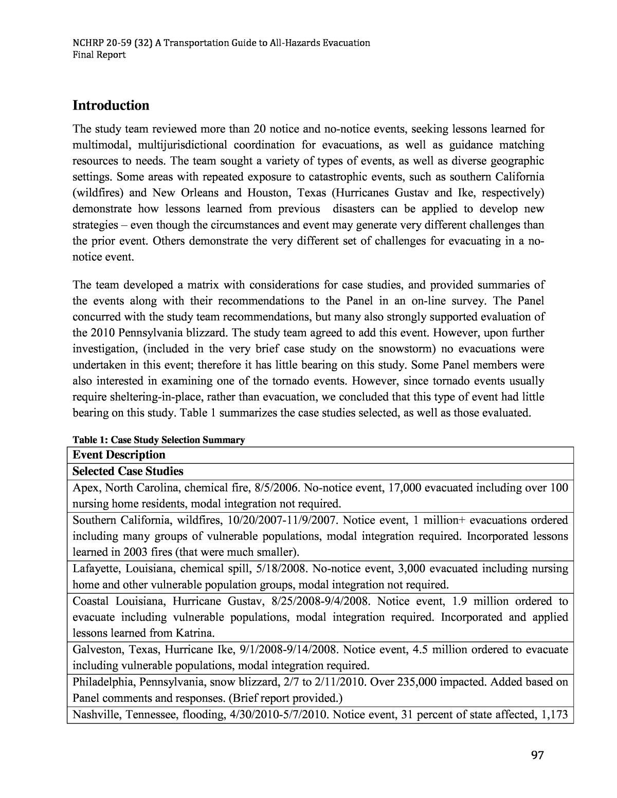
NCHRP 20-59 (32) A Transportation Guide to All-Hazards Evacuation Final Report 97 Introduction The study team reviewed more than 20 notice and no-notice events, seeking lessons learned for multimodal, multijurisdictional coordination for evacuations, as well as guidance matching resources to needs. The team sought a variety of types of events, as well as diverse geographic settings. Some areas with repeated exposure to catastrophic events, such as southern California (wildfires) and New Orleans and Houston, Texas (Hurricanes Gustav and Ike, respectively) demonstrate how lessons learned from previous disasters can be applied to develop new strategies â even though the circumstances and event may generate very different challenges than the prior event. Others demonstrate the very different set of challenges for evacuating in a no- notice event. The team developed a matrix with considerations for case studies, and provided summaries of the events along with their recommendations to the Panel in an on-line survey. The Panel concurred with the study team recommendations, but many also strongly supported evaluation of the 2010 Pennsylvania blizzard. The study team agreed to add this event. However, upon further investigation, (included in the very brief case study on the snowstorm) no evacuations were undertaken in this event; therefore it has little bearing on this study. Some Panel members were also interested in examining one of the tornado events. However, since tornado events usually require sheltering-in-place, rather than evacuation, we concluded that this type of event had little bearing on this study. Table 1 summarizes the case studies selected, as well as those evaluated. Table 1: Case Study Selection Summary Event Description Selected Case Studies Apex, North Carolina, chemical fire, 8/5/2006. No-notice event, 17,000 evacuated including over 100 nursing home residents, modal integration not required. Southern California, wildfires, 10/20/2007-11/9/2007. Notice event, 1 million+ evacuations ordered including many groups of vulnerable populations, modal integration required. Incorporated lessons learned in 2003 fires (that were much smaller). Lafayette, Louisiana, chemical spill, 5/18/2008. No-notice event, 3,000 evacuated including nursing home and other vulnerable population groups, modal integration not required. Coastal Louisiana, Hurricane Gustav, 8/25/2008-9/4/2008. Notice event, 1.9 million ordered to evacuate including vulnerable populations, modal integration required. Incorporated and applied lessons learned from Katrina. Galveston, Texas, Hurricane Ike, 9/1/2008-9/14/2008. Notice event, 4.5 million ordered to evacuate including vulnerable populations, modal integration required. Philadelphia, Pennsylvania, snow blizzard, 2/7 to 2/11/2010. Over 235,000 impacted. Added based on Panel comments and responses. (Brief report provided.) Nashville, Tennessee, flooding, 4/30/2010-5/7/2010. Notice event, 31 percent of state affected, 1,173
NCHRP 20-59 (32) A Transportation Guide to All-Hazards Evacuation Final Report 98 Event Description evacuated, mobile homes and schools impacted, modal integration not required. Evaluated but not Selected North and Central California wildfires, 5/22/2008 â 8/29/2008. Notice event, over 2,000 evacuated, many vulnerable population groups impacted, modal integration required. Incorporated and applied lessons learned from 2007 southern California wildfires. Note: Although this was initially recommended, upon review the PI decided that the more comprehensive review of the much larger 2007 southern California wildfires, including the lessons learned from the 2003 wildfires, provided sufficient lessons for the wildfire-type event. Washington state, Mt. St. Helens volcanic eruption, 5/18/1980. Notice event, over 200 evacuated, modal integration not required. Length of time since event greatly hampers investigation. Central Kentucky flooding, 3/1/-3/16/1997. Notice event, 50,000+ impacted, multimodal integration required. Length of time since event hampers investigation. New Mexico Cerro Grande fire, May, 2000. Notice event, over 400 evacuated. Parkfield, California, earthquake, 9/28/2004. No-notice event, over 13,000 evacuated including vulnerable populations. Minneapolis, Minnesota, bridge collapse, 8/1/2007. No-notice, 158 evacuated, no multimodal integration, but regional coordination was required. Alaska flooding, 5/2009. Notice, 236 homes destroyed, multimodal integration required. Louisiana/ Mississippi tornado outbreak, 4/25/2010. Over 800 impacted. Maryland snow blizzard, 2/1 to 2/6/2010. Over 151,000 impacted. Central and East Oklahoma tornado outbreak, 5/10 â 5/13/2010. Widespread damage, modal integration not required. Pike County, Kentucky severe flooding, 7/17 â 7/30/2010. Notice event. Bronx, New York, tornado, 7/25/2010. Notice event, 4,700 impacted. Southern Texas, Hurricane Alex, 6/25-7/2/2010. Notice event. Romulus, Michigan, chemical fire, 8/10/2005. No-notice event, evacuated 32. Northern and Western Hawaii earthquake, 10/15/2006. No-notice event, limited damage, no modal integration or regional coordination required. Regarding terminology for persons requiring additional assistance in emergencies, we subscribe to the National Response Framework definition of access and functional needs that says âspecial needsâ populations may have additional needs before, during and after an incident in functional areas, such as: maintaining independence; communication; transportation; supervision; and medical care. Examples of these populations include: ⢠people who are disabled;
NCHRP 20-59 (32) A Transportation Guide to All-Hazards Evacuation Final Report 99 ⢠People who live in institutional settings ⢠People from diverse cultures who do not speak English (limited English proficiency [LEP]) ⢠Older adults and people who are frail elderly ⢠People who are transportation disadvantaged ⢠Children. We generally use terms such as âindividuals with access and functional needs,â or âpersons with functional needs requiring additional assistance.â However, we use the term âspecial needsâ when we are referring to or quoting directly from a plan or document that uses that nomenclature. We understand that policies are rapidly evolving in this area, towards fully inclusive community preparedness, although we also recognize that practices of inclusiveness are lagging in many communities. Our case studies include examples of the spectrum of practices in this area. The case studies are presented in chronological order, each following the same basic outline. Our suggested outline is included below, to include all phases of the emergency, considerations of persons with access and functional needs, and pet and livestock issues, among other topics such as matching resources to needs. Detailed Case Study Outline Overview Case Setting/ Description Geographic Location Type of Hazard Timing (Notice/No-Notice) Number of People Impacted/Type of Impact/Any Vulnerable Population Groups (Description) ⢠Self-evacuees ⢠Assisted evacuees ⢠Pets and companion animals addressed? ⢠Any livestock issues?
NCHRP 20-59 (32) A Transportation Guide to All-Hazards Evacuation Final Report 100 Preparedness What plans were in place? How did the actual event compare with the scale of the plan? Had previous exercises considered an event comparable to the actual event? Response Matching Resources to Needs Items to consider: resources such as management, personnel, equipment, vehicles, information and data, communication systems, public information; identifying needs such as limitations to highway capacity or transportation-disadvantaged persons who will need transportation assistance; and matching resources to needs. Describe how resources were identified and deployed to meet needs ⢠e.g., highway capacity challenges met with public information, signal timing, contraflow lanes, law enforcement restricting left turns or limiting access to the highway to those in high-occupancy vehicles, or prohibiting access to those not in imminent danger or whatever ⢠buses to assist transportation disadvantaged â how was this done, e.g., went through neighborhoods/sent to pick up points? (How did people know about this, how did they get there, what alternatives were available, etc.) ⢠were community-based groups involved in the response, such as helping locate or communicate with vulnerable populations; ⢠issues with persons with functional needs o unaccompanied children o persons with mobility challenges and/or assistive devices and/or service animals- how were assistive devices either tracked or kept with owner o persons with LEP - if encountered, how handled; o institutional evacuations (nursing homes, correctional facilities, hospitals) - any particular issues; o issues with pets or companion animals - how addressed; ⢠livestock issues and how addressed.
NCHRP 20-59 (32) A Transportation Guide to All-Hazards Evacuation Final Report 101 Modal Integration/Coordination Were multiple modes involved? Were transfers between modes required? How was this handled? Regional/Interregional/Interstate Coordination Describe what was required, what went well, what didnât Recovery Was reentry required? Were there any particular items or lessons for transportation in terms of security, helping keep people together with their belongings and family members, coordinating the timing of reentry with readiness of the site, etc? Preparedness Have the lessons learned in the event been transferred into improved planning (e.g., improved coordination, communications) and/or mitigation (e.g., structural hardening, facility relocations, etc.)? Case Study Key Findings Lessons Learned/ Avoidable Failures Summary/ Conclusions As expected, some events have far more documentation and information available than others; all topics in the outline were not relevant for each case. In one case follow-up interviews were conducted to fill in gaps in information. All references are provided at the end of the document.
NCHRP 20-59 (32) A Transportation Guide to All-Hazards Evacuation Final Report 102 2006 North Carolina Chemical Fire Overview On October 5, 2006, the town of Apex, North Carolina, with a population of only 30,000, was impacted by a fire and series of explosions at the Environmental Quality Company, an industrial chemical processing plant that collected, processed, and repackaged hazardous waste for transport and disposal. Due to the changing winds and inclement weather that prevailed throughout this event, the Emergency Operations Center (EOC) and evacuation zones were continuously modified and expanded, ultimately forcing the evacuation of approximately 17,000 people. Case Setting/Description The evacuations and partial reoccupation took place over a three-day period and involved approximately 17,000 Apex, North Carolina residents, including 100 non-ambulatory special needs nursing home residents. In addition to those residents that evacuated, a number of residents also sheltered-in-place due to the potential hazards of evacuating through the toxic cloud. Geographic Location Apex, North Carolina is located in Wake County, just south of Raleigh, in the central part of the state. It is the fastest growing suburb in the state. Type of Hazard The hazard involved fire, explosions, exposure to hazardous chemicals and toxic fumes, fire extension due to nearby structural exposure to a fuel oil company with 400,000 gallons of diesel and fuel oil, and the environmental impact of toxic run-off contaminating nearby streams. Timing There was no notice for this event. It began on October 5, 2006, at 9:38 p.m.; however, due to the unknown nature of the chemicals involved, the persistent fire, changing winds, unpredictable chemical explosions, and the chemical plume, this incident extended well beyond the first operational period. This incident lasted slightly longer than 48 hours when the last fire at the Environmental Quality Company was extinguished on October 7, 2006, at 1:00 a.m. Number of People Impacted/Type of Impact/Any Vulnerable Population Groups Due to the unknown nature of the chemicals involved and the changing winds, this incident forced the town of Apex with a population of 30,000 to evacuate more than half of its residents. Approximately 17,000 people were evacuated prior to the eventâs demobilization. Residents of the homes nearest to the Environmental Quality Company facility were forced to shelter-in-place to prevent possible exposure to the chemical plume.
NCHRP 20-59 (32) A Transportation Guide to All-Hazards Evacuation Final Report 103 Apex EMS coordinated with local EMS, area schools, and public transportation to evacuate 100 non-ambulatory nursing home patients into local Wake County hospitals. This operation took approximately 4 hours and was completed with no injuries. Response Evacuation response to the Apex chemical fire started within minutes of the establishment of the Incident Command at 9:52 p.m. Facilities in close proximity to the Environmental Quality Company facility, including a gymnastics center, fuel-oil company, and woodworking shop were notified by on-scene first responders and self-evacuated. Notification and warnings were sent out to the residents of Apex via the townâs reverse 911 system. This system provided information on the event, as well as information for those asked to shelter-in-place. School buses were provided by the local school board to assist with the evacuation. Apex police officers were dispatched to the neighborhoods directly downwind from the facility and went door-to-door notifying the residents of the need to immediately evacuate the area. Apex EMS, working in cooperation with the school board, public transportation, and other area EMS providers, evacuated 100 non-ambulatory nursing home patients to area hospitals within Wake County. As stated previously in this case study approximately 17,000 residents of the town of Apex were evacuated throughout this incident. Reoccupation of the evacuated areas was conducted in zones and controlled by the Apex Police Department Matching Resources to Needs The town of Apex is entirely within the Emergency Planning Zone (EPZ) of the Shearon Harris Nuclear Power Plant. The town officials, first responders, and residents plan, train, and exercise regularly for possible wide-scale evacuation due to their close proximity to the reactor. A federally mandated requirement for biannual exercise at the Shearon Harris Nuclear Facility and the townâs participation in this exercise program foster a sense of coordination, cooperation, and familiarization of capabilities between Apex and the surrounding areasâ response organizations. Modal Integration/Coordination Due to the fact that this was a no-notice event, and a non-specified chemical hazard, along with the changing winds during this 48 plus hour incident, various systems were utilized in the evacuation of residents. The majority of the residents self-evacuated via personally owned
NCHRP 20-59 (32) A Transportation Guide to All-Hazards Evacuation Final Report 104 vehicles (POVs) to provided shelters upon notification. Public transportation along with the school board provided buses transportation for those without access to POVs or other means of transport. Apex EMS and other area emergency medical agencies provided transport for non-ambulatory and patients with functional needs requiring additional assistance. Case Study Key Findings The success of the evacuation of more than half of the townâs population during this incident with no reported injuries was due primarily to the on-going planning and training, and community exercises that occur as a result of their location within the Shearon Harris Nuclear Plant EPZ. As a result of the public outreach programs that are in place to educate the town residents on evacuation and shelter-in-place procedures, the entire town is familiar with and kept up to date on these procedures. This knowledge was key to the rapid and organized evacuation during this incident. Lessons Learned/Avoidable Failures According to a FEMA report on the incident, there were several lessons learned and areas identified for improvement (FEMA 2008). Lessons Learned ⢠Interagency coordination and cooperation improved the functionality of responders. ⢠The entire operation was able to adapt to frequently changing conditions. ⢠Tactical decisions were made efficiently and effectively. ⢠The public information officer was very effective. ⢠The evacuation was well planned. ⢠Incident Action Plans were used routinely by the Incident Command. ⢠Training is the most critical part of successful incident mitigation. Areas for Improvement ⢠The evacuation of people with functional needs requiring additional assistance was not well planned (the evacuation plan had to be developed ad-hoc, and worked well, but had not been sufficiently considered in advance). ⢠A remote staging area was not identified and used.
NCHRP 20-59 (32) A Transportation Guide to All-Hazards Evacuation Final Report 105 ⢠Geographic Information Systems (GIS) and Computer Aided Design (CAD) should be functions of the EOC Planning Section. ⢠Public information functions must be well-placed and effective. Summary/Conclusions Pre-event planning and training, and exercises in an all hazard environment assisted in providing a positive emergency incident response outcome. In addition, the pre-incident public education of the town residents made them familiar with the evacuation and shelter-in-place plans. This knowledge, combined with their readiness to cooperate, greatly assisted first responders and local and state officials in successfully mitigating this incident with only minor exposure issues.
NCHRP 20-59 (32) A Transportation Guide to All-Hazards Evacuation Final Report 106 2007 Southern California Wildfires Overview Wildfires have been a part of the regeneration cycle of natural lands throughout history. However, as cities continue their inexorable outward push into these undeveloped lands, wildfires now routinely impact inhabited communities and the constructed systems that support them. One area where brush and wildfires have become a significant hazard is in southern California. The unique combination of climate, geography, vegetation, a sprawling population, and extensive land development has made this region particularly prone to dangerous, costly, and highly destructive wildfires. In 2003 and 2007, natural fires within the urban-wildland interface areas of southern California produced some of the most hazardous and destructive conditions in recent times. The 2003 fires burned more than 430 square miles, claimed 24 lives, destroyed more than 3,600 homes (Campbell 2004), and resulted in the evacuation of about 100,000 residents. Four years later, wildfires in the same region burned more than 780 square miles (EDD 2007), claimed an additional 12 lives, destroyed more than 2,200 homes, and precipitated the evacuation of nearly 1 million people. The destruction brought by these events was unfortunate; however, California officials used these experiences to make changes to emergency preparedness and response, and as a result, are now better prepared for and able to deal with the effects of such events. The California wildfire experiences of 2007 are used here as a case study to illustrate the effects of these hazards and to assess the impact of changes made as a result of the 2003 fire. The 2007 fires, coming so close on the heels of those in 2003, provide an opportunity to observe and assess the effectiveness of the improvements that were implemented in the four years that followed. In addition to reviewing the general conditions of the wildfire hazards and emergency responses that occurred, this case study also focuses more specifically on the planning, management, and operation of the evacuation-related aspects of the fire experiences. While this case study does not permit a detailed discussion of all of the important details, interested readers can find a more in- depth discussion of the emergency preparedness and response aspects in Jones, et al., (2008) and Wolshon (2009). Case Setting/Description The fire-related evacuations in California provide an interesting case study because of their differences from other mass evacuations, particularly hurricane evacuations along the Gulf and Atlantic coasts and other smaller-scale evacuations for natural and man-made hazards (floods, fires, chemical spills, etc.) in other areas of the country. Although many of these differences stem from the nature of the fire itself, many others reflect the characteristics of the local population as well as the geography and transportation systems that are specific to southern California. A
NCHRP 20-59 (32) A Transportation Guide to All-Hazards Evacuation Final Report 107 comparison of the various events with the benefit of hindsight suggests that the effects of combinations of factors both helped and hindered various aspects the evacuation process. For example, unlike the plans for hurricanes that rely on a pre-planned network of routes, phasing, and destinations because the general approach pattern and timing of the hazard is well- known, wildfire evacuation plans can only use a general framework that must be able to change quickly in response to the speed and direction of the fire. Similarly, since the many fires occurred in isolated mountainous areas, many of the wildfire evacuations took place on two-lane, low- speed roadways rather than on high-speed, high-capacity freeways and arterial routes. Another difference was that interviews with local officials indicated that many of the fires occurred in areas with a relatively affluent, well-informed, and highly mobile populace who were well- prepared, willing, and able to evacuate on short notice. This is in contrast to areas of New Orleans where a significant percentage of the population was unable and/or unwilling to evacuate. Geographic Location The wildfires of 2003 spanned a two-week period from late October to early November, and, at the time, were regarded as the largest in the state's history. The fires were spread over a multi- county area that included four primary fire zones, three in San Diego County and one in San Bernardino County. It was estimated that more than 100,000 people were evacuated during the period of the fires. Four years later, another series of fires over nearly the same two-week period were significantly larger than the 2003 event. In October and November of 2007, a series of more than 20 wildfires burned across a seven county area from Los Angeles and San Bernardino counties to the north, down to San Diego and Imperial counties near the Mexican border in the south. In total, these fires affected an area nearly double that of 2003 and precipitated the largest evacuation in Californiaâs history, with some estimates suggesting that nearly a million people were relocated (LA Times 2007). While many causes contributed to the scale and scope of the 2007 California wildfires, most experts conclude that drought conditions, prevalent in the area for at least 10 years, were the underlying factor that allowed the fires to spread as quickly as they did. Beginning in 1991, southern California experienced 7 years of significant drought, with 2007 being classified as an âextreme droughtâ year by the Climate Prediction Center. In addition to drought conditions, the spread of the fires was further amplified by the seasonally hot weather and strong Santa Ana winds (wind gusts during this period were recorded as high as 85 miles per hour [mph]), which created favorable conditions for the rapid spread of wildfires. Type of Hazard Wildfires present unique challenges to emergency officials with regard to conducting evacuations. While many coastal communities have detailed plans and specific timelines to initiate emergency evacuation procedures for hurricanes, wildfires tend to be unpredictable and
NCHRP 20-59 (32) A Transportation Guide to All-Hazards Evacuation Final Report 108 event-driven. Without the aid of wind, brush and wildfires might only advance at walking speeds of 1 to 5 mph. Under the influence of high winds; however, they have the potential to move at speeds of 60 or 70 mph, or more. These speeds are achieved when embers from the flame tops are blown to new locations and new flames are ignited. In addition to their speed, wildfires can move in irregular directions. They do not move with a singular front, rather they move in the prevailing wind direction as hot embers carried aloft by high winds ignite âsub-firesâ in locations miles from the original source. Such movements can cause significant complications in evacuations, because fires can skip over roads that may be used as fire breaks in addition to evacuation routes and move toward areas that previously provided safe shelter, effectively encircling at-risk populations. Timing Although some aspects of wildfire evacuations are similar to evacuations for other hazards, they differ most significantly from evacuations for hurricanes because they are much more fluid. The 2007 wildfires, similar to most wildfires, had no set origin and pattern of movement. As such, most evacuation plans for wildfires have no formally declared routes or temporal trigger points that govern when to initiate certain actions. Rather, actions are implemented based on a general framework in which a basic template of action exists. This involves a fire department's order of where and when to evacuate with a corresponding law enforcement agencyâs role to determine how best to carry out the evacuation. Some areas, like the mountainous regions of San Bernardino County, do not even have designated emergency routes as the routes out of the area are already limited. Because fire conditions warrant the priority movement of some areas before others, phased evacuations were implemented in 2007 by ordering certain areas to evacuate earlier. Emergency response personnel stated that using tools like the AlertSanDiego system (San Diego County OES 2010) to target earlier calls to the most threatened zones first were helpful. Although, in some situations, even when evacuations were initially staged, they were often quickly overcome by the size and speed of the fire and became more general, large area evacuations. Number of People Impacted/Type of Impact/Any Vulnerable Population Groups Similar to most other evacuation events, the exact number of residents who evacuated in advance of the 2007 fires, when they left, where they came from, and where they went is not known for certain. However, several sources suggest that there were a total of 1 million evacuees during, making it the largest in the history of California. The type of evacuation and when the orders were issued were a function of the speed and movement (direction) of the fires. Reports and interviews show that evacuation orders were made on both a mandatory and voluntary basis during the event. The following sections briefly highlight the evacuation processes for the various evacuee groups based on their mobility status.
NCHRP 20-59 (32) A Transportation Guide to All-Hazards Evacuation Final Report 109 Self-evacuees The vast majority of evacuees during the wildfires were self-evacuators. Interviews with local officials suggest that the general high level of mobility of residents of southern California helped in this respect. Another finding from interviews was that the population tended to be (1) more knowledgeable of evacuations based on prior experience; (2) educated and aware of the potential dangers; and (3) prepared to leave quickly with their critical belongings. Interviews also found that there were no special proactive traffic management techniques like contraflow or priority signalization during the 2007 fire event. In general, such actions appeared to be viewed negatively because of the additional control manpower they would likely require. Despite this, contraflow operations were seriously discussed for Ramona (north of San Diego) by local officials, but they were never implemented. In interviews, San Diego city officials indicated that contraflow was used on a major roadway in the 2003 Cedar Fire, also near Ramona. Another alternative method of traffic control utilized by the mayor of San Diego focused primarily on limiting general traffic demand on the area roads. He requested that people stay home and off the roads to free capacity for evacuee traffic, responders, and for the basic safety of all. While the impact of the request was not measured directly, it demonstrated that a proactive message and effective utilization of the media to convey information can facilitate emergency actions. People with Functional Needs Requiring Additional Assistance and Other Assisted Evacuees The 2003 fires had a significant impact on lower income families, the elderly, and special needs individuals (OES 2004). The Governorâs Office of Emergency Services identified this as an area where improvement could be made (OES 2004). There were no identified reports indicating that residents were unable to evacuate because of functional needs requiring additional assistance or lack of transportation. The State Independent Living Council (SILC) had participated in statewide disaster planning for many years prior to the fires. Transit for individuals with functional needs requiring additional assistance was available in some areas. The Mountain Area Rural Transit Agency (MARTA) evacuated dozens of people with disabilities. This was successful because MARTA drivers knew where their frequent riders lived (SILC 2004). Lists of disabled individuals were available in the fire departments; however, with most firefighters in the field, office activities were very limited and the disability lists were not accessed. Although the evacuation of threatened populations proceeded relatively smoothly, some issues associated with the movement of dependent and functional needs populations during the 2007 wildfire event were noted. QualComm stadium was opened as a city-run, mega-care and shelter facility beginning on October, 22, 2007 (AAR 2007). The facility received thousands of evacuees, individuals with functional needs requiring additional assistance, and animals. Approximately 400 nursing home patients created medical and logistical needs not previously experienced at the shelter (AAR 2007).
NCHRP 20-59 (32) A Transportation Guide to All-Hazards Evacuation Final Report 110 In addition to the threatened population, 14 nursing homes evacuated nearly 1,200 residents in San Diego County (per the California Department of Public Health). There were also 85 assisted- living facilities that evacuated 2,189 seniors. Two acute care hospitals and a psychiatric hospital were temporarily shut down as a result of the fires (LA Times 2007). During the emergency, some elderly and infirm groups experienced some difficulties in evacuating. Of the 3,300 nursing home residents and elderly residents who evacuated, six were reported to have died (LA Times 2007). In San Diego, the Office of Emergency Services estimated that more than 1,000 seniors were moved through transit buses and EMS assets. This was the only noted use of transit assets in San Diego County for this evacuation. Due to San Diegoâs location near the Mexican border, the county is home to a large migrant worker population. During the 2007 wildfires, reports indicate that there were several challenges in meeting the needs of this diverse group. There were several factors that contributed to the difficulties in evacuating this group, including: ⢠a lack of English-speaking proficiency that may have resulted in a lack of communication, confusion, and misunderstanding of evacuation and sheltering orders; ⢠a lack of trust of public officials because of possible illegal immigration status or prior negative encounters with law enforcement and immigration agencies; and ⢠limited financial resources to cover non-working periods. Because of these issues, some migrant workers in California were reported to have remained in agricultural fields, even when under a mandatory evacuation order, and some were denied entry at shelters because they did not possess adequate identification (NPR 2007). Although city officials pointed out that no one was killed or injured as a result of not evacuating because of language barriers, the cityâs After Action Report did document a âchronic lack of translators, which hindered the ability to evacuate and/or provide other emergency servicesâ (City of San Diego 2007). A final area of concern noted during interviews with officials, classified under âassisted evacuation,â was evacuation of children, including those at home during an evacuation order without adult supervision (i.e., latchkey children) or home with adult family members who chose not evacuate under mandatory evacuation orders. When notified by a parent, latchkey children were picked up by police who were on patrols in affected areas. Non-evacuating families were somewhat more complicated. While first responders in San Diego County noted that they did not have the capability to force citizens to evacuate under a mandatory evacuation, they did feel under existing child endangerment laws that they had the legal authority to forcibly remove children from a house during such an emergency. Interestingly, they found if they threatened the parents with a forced removal, the entire family would end up evacuating â99.9% of the time.â
NCHRP 20-59 (32) A Transportation Guide to All-Hazards Evacuation Final Report 111 Pet and Livestock Evacuations Throughout the 2007 evacuations, residents were encouraged to evacuate with their pets. During the wildfire emergency, all of the communities involved supported the evacuation of pets with the residents. In San Diego and San Bernardino counties, officials set up pet-friendly evacuations shelters and even accommodated pets at QualComm stadium. The estimates were that there were between 10,000 to 15,000 pets located in evacuation centers. The website Petfinder.com set up a 24-hour call center to link evacuees with volunteers willing to provide temporary homes for displaced pets. Lists of pet-friendly hotels were given for Southern California. Typically hotels were allowing pets to stay at the hotels for no extra cost. San Diego Humane Society and the Society for Prevention of Cruelty to Animals provided information regularly on their websites about animal evacuation centers. The 2007 evacuation also included the evacuation of large livestock animals. Although much of the evacuation took place in urbanized areas, the extent of the fires was such that significant areas of open range land were also impacted. Because of this, local officials found that many people were evacuating with their horses. The region around San Diego is well-known for equestrian facilities; and arrangements were often made through such facilities. The San Diego Police mounted patrol also used their horse trailers to help evacuate horses out of impacted areas. At QualComm stadium, provisions were also made to shelter large animals like horses. Many people who could not evacuate with their horses left gates open to let horses run free in case they became cornered by the fire. These horse owners felt that if they could not be moved, the horses would have a better chance of survival on their own rather than being penned in an area with no means of escape and that they would be rounded up later after the fires were extinguished. Preparedness California is a mutual-aid state, and the effort to fight the fires in 2007, coordinate the evacuations, and accommodate the needs of the displaced and injured residents was shared among agencies at all jurisdictional levels, including city, county, state and Federal governments. Fire fighters and emergency management and response agencies also benefitted from the lessons learned from previous fires, most notably the wildfires of 2003. Interviews with local officials found that all of these factors combined to save both people and property from even greater losses. However, the interviews also showed that despite these successes, the knowledge gained from recent experience, and the benefits achieved from the shared effort, the enormous size and fast-moving nature of the 2007 fires combined with the enormous populations in the area did result in some problems of communication, coordination, and public response. An official After Action Report conducted by the city of San Diego documented both the lessons learned from the event, as well as recommendations to address them in the future (AAR 2007).
NCHRP 20-59 (32) A Transportation Guide to All-Hazards Evacuation Final Report 112 Response The unpredictability of wildfires typically means that no formal written evacuation plans are developed. Under such conditions, emergency officials attempt to establish âtrigger pointsâ where fires pass a certain location and then the decision to initiate an evacuation for a specific area is implemented. Pre-determined evacuation routes do not exist and areas to evacuate are determined based on the nature of the wildfire. Decisions of when and where to evacuate came from fire department officials who typically served as local Incident Commanders. Meetings with local officials showed that fire department officials designated where and when to evacuate based on knowledge and experience of weather conditions, fuel source availability, and threats to population. However, it was clear that their job was to fight fires and not evacuate people. The actual evacuation process was managed and controlled by law enforcement agencies. The fire departments developed âevacuation boxesâ based on recognizable and understandable physical boundaries like highways and waterways then they relayed this information to law enforcement and the city/county emergency operations centers. With the decision was made to evacuate, law enforcement and transportation officials were responsible for developing the mechanisms to initiate the evacuation plan and carry out the evacuation order. Local departments of transportation and departments of public works played a minor role overall in the evacuation by providing barricades, variable information signs, and closing roads as directed by law enforcement officials. In San Bernardo County, evacuations were complicated by the fact that many of them took place from rural mountainous areas with very limited routes of egress. In some cases there was only a single route out of the impacted areas. Some evacuations in these areas also took place at night through areas without power. Such conditions not only interrupted the movement of traffic, they also made communication with potential evacuees more difficult, since many did not have access to television or radio. In addition to lost power lines and hampered communications, numerous roads were closed at various times during the fire event. At least five interstate freeways were closed during some period of the incident (CDF 2004). Because of this, some local residents were advised to shelter-in-place because routes of egress were closed due to the fire or because fire conditions made it too dangerous to evacuate an area. Matching Resources to Needs Although there are several examples of how resources were matched to address needs during the 2007 California wildfire evacuations, one of the most important was the matching and application of communication resources during the event. Communication difficulties, between and across jurisdictions, levels of government, agencies, responder groups, and with the public are consistently cited as one of the areas most in need of improvement after major emergencies â
NCHRP 20-59 (32) A Transportation Guide to All-Hazards Evacuation Final Report 113 especially those involving evacuations where timing is critical and correct information can often mean the difference between life and death. Communications with Responders One of the major shortfalls identified during the 2003 wildfires was a lack of interoperable communications equipment among the first responder agencies. In the years after 2003, San Diego County officials worked to address this shortfall and generally acknowledged that communications among first responders was considered a major success during the 2007 wildfires. The overwhelming opinion was that communications were handled quite effectively from within and between the various responding agencies. San Diego County utilizes two different 800 megahertz (MHz) trunked systems: a regional system for San Diego and Imperial counties and a dedicated system for the city of San Diego. In 2007, the Department of Homeland Security ranked the San Diego Tactical Interoperable Communications Plan as one of the four highest scored out of 73 evaluated cities. While the system overall performed well, there were a few noted deficiencies. This included a shortage of 800 MHz radios among firefighting crews that may, at times, have slowed the deployment of firefighters and equipment at various times and locations. Another identified shortfall was the lack of tactical channels for unit-to-unit communications. This limitation led to overcrowding on the available channels and the delay of information exchange at time when the bands were filled. Another example of effective tools in San Diego County were the web-based emergency management communication tools like WebEOC® software that made it possible for up to 500 agency representatives to have complete, instantaneous, and full situational awareness. The primary function of the WebEOC® platform is for local government to process resources requests through a single system and to provide situational awareness reports to allow those logged into the system to see what is going on throughout the disaster event. Since the tool is web-based, all local and state agencies, including CalTrans, were able to maintain situational awareness and respond to resource requests throughout the duration of the wildfires. Communications with the Public To educate the public, issue evacuation orders, and provide up-to-the-minute information on the wildfires, the city of San Diego employed a range of communication assets to ensure that the necessary information reached its citizenry. The city reported utilizing the following methods to communicate with the public: ⢠Door-to-door knocking by first responders ⢠Police and fire rescue vehicle sirens ⢠Police and fire rescue vehicle and helicopter lights
NCHRP 20-59 (32) A Transportation Guide to All-Hazards Evacuation Final Report 114 ⢠Constant monitoring and information flow to media outlets for dissemination to the public ⢠Emergency alert system via television media ⢠AlertSanDiego mass notification system ⢠Community access phone system ⢠211 information line ⢠Individual and community preparedness One of the key areas identified for improvement following the 2003 wildfires, was the ability to directly alert the public of emergency information during periods of disasters. To address this need, San Diego invested in the AlertSanDiego system, a citizen call ring down system. The AlertSanDiego system was populated with listed and unlisted phone numbers provided by the counties 911 database. While the system was only designed to alert citizens through land-lines, citizens were also able to register their mobile devices and sign-up for text messaging at the counties website, ReadySanDiego.org. Another strength of the AlertSanDiego system is its ability to designate areas through the creation of polygons on a county map to ring down just the area that has been selected on the map. This was an ideal system for conducting evacuations in this type of environment because once the fire departments identified an âevacuation box,â AlertSanDiego was able to notify just those individuals physically located within the evacuation area. This minimized the number of phone calls to be made and avoided calling out an entire zip code or area code. Through this system, San Diego reported that it was able to issue approximately 12,000 calls an hour. The county was also able to utilize the 211 call system to relay non-emergency information to the public. The 211 prefix was set aside by the Federal Communications Commission for the public to obtain non-emergency related information. During the 2007 wildfire, 211 received more than 120,000 calls and was staffed with more than 1,200 volunteers. By utilizing the 211 service, citizens in San Diego County were able to receive up-to-the-minute information about evacuations, shelters, road closures, volunteer and recover information, and services. More important to emergency officials, the system was useful to relay non-emergency related agency contact numbers, allowing the general population to contact these offices directly instead of utilizing emergency dispatchers to give out numbers or transfer calls to others.
NCHRP 20-59 (32) A Transportation Guide to All-Hazards Evacuation Final Report 115 Modal Integration/Coordination Although some modes of transport other than personal, automobile-based exist, they were limited to busses for the elderly and nursing home residents. No transfers between modes were noted. Regional/Interregional/Interstate Coordination Overall, the 2007 evacuations were reported to have progressed fairly well, considering the extent of the areas affected and the number of people that were involved. A significant reason for the positive results was the coordination enhancements based on the lessons learned from and improvements made after the 2003 fires. One of these improvements was the enhancement in response coordination between the various jurisdictions and their individual agencies. Although much of this coordinated response was focused on fighting the fires, the coordination of evacuation activities was also a part of this. Even though the 2007 wildfires were spread over two mutual aid regions and seven counties, similar to most locations, decisions to evacuate were made at the local level. The California Department of Forestry and Fire Protection provided overall command and developed mitigation strategies to fight and ultimately contain the fires. It employed several area commands, usually at the county level, which provided coordination and prioritized resources. In addition, the Incident Command System, which incorporated a local unified command, was established with local fire departments taking the lead in fighting fires within their areas. Typically, the decision to evacuate was the responsibility of the local Incident Commander or in some cases, local authorities, which were most often fire departments. At various times during the fires, up to 15 major roadway routes were closed due to dangerous fire conditions. However, these closures did not appear to impact the evacuation. Most notably, all of the most heavily traveled highways of Interstates, 5, 8, and 15, were closed at different times. To address this situation, local officials worked with their Federal counterparts at the Camp Pendleton Marine Corps Base to permit public use of on-base roadways for evacuation traffic to access northbound of Interstate 5 in lieu of Interstate 15. One of the ways in which the California Department of Transportation (CalTrans) assisted with road closures was through the release of the CALTRANS COMMUTER ALERT that provided location and details about road closures throughout the seven county area. These road closures were also illustrated through geographic information systems (GIS) by providing detailed maps that depicted the road closures as well as the perimeters of the wildfires. Both San Diego and CalTrans provided mapping services to assist responders and the general population during this period. CalTrans also had representation in the local emergency operations centers (EOCs), in addition to establishing its District Command Centers. Both local EOCs and the District Command Centers included key management and staff. CalTrans assisted with the coordination of emergency response, evacuations, and route closures with assistance from the California
NCHRP 20-59 (32) A Transportation Guide to All-Hazards Evacuation Final Report 116 Highway Patrol. CAL-TRANS also mobilized maintenance and construction crews to assist in route closures, traffic control, and field damage assessments (CalTrans, 2007). Recovery The reentry of evacuees into impacted areas after the fires was another important concern. San Diego County, like many counties throughout the U.S., does not have a formal plan for reentry following the containment of the wildfires. Officials noted that a managed and controlled reentry for the San Diego was considered to be practically impossible. While formal plans were not developed for reentry, a set of informal guidelines allowing reentry into certain areas were followed. The primary concern for reentry was public safety to ensure that areas were safe to re- occupy. Utility companies focused on securing utilities; however, this did not mean that all utilities were restored prior to reentry. CalTrans Damage Assessment teams also certified the safety of state and federal roadways. The CalTrans Damage Assessment Teams addressed immediate safety needs for re-opening route segments. Its immediate priorities were slope stabilization; erosion control, guardrail, signage, culverts/drainage, and electrical requirements for call boxes; lighting, etc. CalTransâ efforts resulted in all route segments being re-opened within two weeks. While a controlled reentry was not possible for the entire San Diego County, there were examples of isolated neighborhood-sized areas in which a controlled reentry was established. In these instances, a local assistance center was set up at the entry point to an area. This center included many different services to âhelp effected people get their lives re-started.â In addition to managing access, these centers were also meant to provide security against looters, provide safety hazards within the area, and identify unscrupulous contractors. Before permitting reentry into an area, the fire department conducted assessments to check for natural gas, electrical, and other potential hazards. Once individuals obtained the necessary credentials, they were then required to check-in and were granted access only during daylight hours. This process was repeated daily until authorities allowed for a full reentry. San Diego officials also maximized the use of the reentry assistance centers by co-locating grief counselors to assist those who experienced difficult emotional issues as a result of the wildfires. Case Study Key Findings The Southern California wildfires of 2007 precipitated the largest evacuation in California history. Emergency response personnel were able to effectively manage the evacuation of this disaster by incorporating many of the lessons learned from the 2003 wildfires that burned over similar areas. These fires led to the development of several key preparedness and response measures, primarily management-related and some indirectly related to evacuation. Among the most significant measures were the incorporation of the incident command system through all levels of response, enhanced interoperable communications for first responders, and an effective
NCHRP 20-59 (32) A Transportation Guide to All-Hazards Evacuation Final Report 117 plan to communicate to the public San Diego officials. These measures helped minimize the loss of life and property. Lessons Learned/Avoidable Failures Following the 2003 fires, the governor of California formed the Blue Ribbon Commission to conduct a review and present recommendations to help make California less vulnerable to fires in the future (Campbell 2004). In addition to the Blue Ribbon Report, many after action reports and lessons learned documents have been published that also assess elements of the response to the fires. These reports provide a basis to assess the effectiveness of improvements that were integrated as a result of lessons learned. The intent was to determine how these lessons learned may have benefitted or improved the response in 2007 and whether such improvements might be beneficial to the Nuclear Regulatory Commission and/or FEMA emergency preparedness program. In the development of after action reports and other studies related to the evacuations in 2003, many lessons were documented. Lessons learned, findings, and recommendations for the 2003 fires were identified in the Blue Ribbon Report (Campbell 2004) and include: ⢠There were no minimum statewide training standards. ⢠A comprehensive public awareness program was needed. ⢠Communications interoperability was essential for effective command and control during multi-agency, multi-disciplinary responses to major incidents. ⢠It was recommended that all EOCs dedicate a Public Information Officer or establish a joint information center. ⢠It was recommended that local governments improve public outreach and emergency evacuation education. Agency after action reports and post-incident assessments also included lessons learned in core areas of training, preparedness, education, and communication (CDF 2005). Some of which include: ⢠Implementation of a joint information center was needed early in an incident to provide a unified message to the community, public, and media (Maxfield 2004). ⢠Development of a multijurisdictional evacuation plan was needed (Mutch 2007). ⢠Radio communication problems caused coordination problems between agencies and units in the field and prohibited effective situation awareness (Maxfield 2004).
NCHRP 20-59 (32) A Transportation Guide to All-Hazards Evacuation Final Report 118 ⢠Cell phones can augment communications, but these systems become overloaded. ⢠There was a need to provide evacuation information Spanish as well as English (CDF 2004). ⢠Agencies that had trained together functioned more effectively as a unified team (Maxfield 2004). In the wake of the 2003 fires, public education improvements included an increase in the number of Fire Safe Councils to more than 90 (CDF 2004). Fire Safe Councils primarily address pre-fire management such as fuel reduction and protection of communities and are a means of integrating community support (Campbell 2004). Information staff has been increased (CDF 2004) to provide additional individuals who are instrumental in the proactive education of the public, officials, and the media regarding the increased risk of wildfire (CDF 2004). Communication with the public, including timely notification, is vital if an area is to be evacuated prior to the onset of the hazard. Multiple methods of communication with the public are usually attempted. In 2003, the Cedar fire moved quickly and evacuation notification for this fire was primarily by door-to-door contact or via loudspeakers on emergency vehicles. San Diego County normally would also use the emergency alert system, but it was deemed impractical at the time because the information would be inaccurate due to the swiftness of the fire and the late hour of the notification at 12:01 a.m. (CDF 2004). In 2007, the city of San Diego used all methods available to notify the public of the need for action. Methods used to notify residents in the path of the Witch Creek/Guejito fire included: ⢠Door-to-door; ⢠Police and fire sirens; ⢠Police and fire vehicle and helicopter lights; ⢠Media outlets; ⢠Emergency alert system; ⢠Reverse 911®; ⢠AlertSanDiego mass notification system; and ⢠Community access phone system. In addition, the 211 information line was available with operators who had current knowledge of the incidents. San Diego County personnel said that the 211 system, although overwhelmed in
NCHRP 20-59 (32) A Transportation Guide to All-Hazards Evacuation Final Report 119 this response, was helpful in reducing calls into the 911 emergency system. The Reverse 911© system sent out almost 15,000 calls predawn on October 22, 2007, to notify residents of mandatory evacuations (AAR 2007). Because of the rapid spread of the Guejito fire, it was not possible to construct and launch a Reverse 911® session prior to arrival of the flames (AAR 2007). AlertSanDiego was also used and is similarly to the Reverse 911®; however, AlertSanDiego has additional benefits including the ability to dial numbers based on geographic location whereas the Reverse 911® dialed numbers in numerical order. A community access phone system was also available in San Diego to provide a direct information line to the public. During the Cedar fire of 2003, 12 lines were established for this system, whereas in 2007, 20 lines were available and operators answered more than 12,300 calls. Summary/Conclusions Although both the 2003 and 2007 Southern California wildfire events included evacuations, the 2003 fires only involved about 100,000 evacuees while the 2007 fires included more than 900,000 evacuees. A primary reason for this difference was the rapid spread of the 2007 fires. Fire departments made evacuation decisions based on the best information available, including from fire spotters that were located well ahead of the flames to monitor the spread. During both events officials ordered both mandatory and voluntary evacuations for areas that could be potentially affected. The evacuations in most areas began as staged events with voluntary and mandatory evacuation areas identified. Response personnel stated that most fires moved so quickly that the staging became more of a general evacuation. At least five Interstate highways were closed for a period of time during the 2003 fires and two Interstates were closed during the 2007 evacuations. In each incident, the loss of these roadways affected the evacuation. CalTtrans worked with police to establish evacuation routes. This included use of traffic video information to help communicate evacuation congestion. To help alleviate unnecessary congestion, the mayor of San Diego asked that people who did not need to travel refrain from driving during the peak of the evacuations. Following the 2003 California fires, state, city, and county agencies prepared assessments of lessons learned and needs to improve response and reduce risk in the future. In 2007, another series of fires occurred in California prompting the evacuation of almost ten times the number of residents evacuated in 2003. The evacuation of more than 900,000 residents was widely viewed as successful. The implementation of improvements developed from these lessons learned were clearly instrumental in supporting effective communication among responders and the public, facilitating massive evacuations, and sheltering thousands of evacuees. The insights from the study of these fires support that implementation of lessons learned can occur quickly and have beneficial impacts on response. In the review of the 2007 California fires, there were few new lessons learned. The need to plan for the evacuation of latchkey children became evident when the San Bernardino Sheriffâs Department began receiving calls from parents. Another lesson learned, although obvious to the firefighters, was the need to be prepared to respond to wind
NCHRP 20-59 (32) A Transportation Guide to All-Hazards Evacuation Final Report 120 shifts and changes in direction of the hazard. Emergency planning for nuclear power plants contains no specific guidance for evacuation planning of latchkey children. This is addressed under the broad requirement that planning be in place for the public. With regard to the changing direction of the hazard, emergency preparedness around nuclear power plants includes deployment of plume trackers to identify the bounds of the plume. This action, as well as expanding the evacuation area when needed, is tested in large exercises. The evacuation of pets was very proactive in the 2003 and 2007 fires. In 2007, the San Diego Sheriffâs Department mounted patrol assisted with the evacuation of hundreds of horses using department horse trailers when needed. People were encouraged to evacuate their pets, and shelters in many instances accommodated these animals. Individuals with Functional Needs Requiring Additional Assistance In 2007, the population with functional needs requiring additional assistance that was evacuated was considerably larger than in 2003. Discussions with response personnel revealed that when necessary, and certainly not optimal, response personnel evacuated individuals in their patrol cars and even in fire engines if lives were at risk. In San Bernardino, the Sheriffâs Department had to support the evacuation of latchkey children left at home while parents were at work. The children were later reunited with parents at evacuation logistics centers. Also in San Bernardino, the local community bus service for the mountain areas ran virtually non-stop to evacuate residents with functional needs requiring additional assistance. The service picked up people who were regular riders and also responded to requests when residents called for assistance. In general, in San Diego, the areas that required evacuations were homeowners with vehicles. There were as many as 11 special facilities evacuated and the residents were taken to comparable facilities outside the evacuation zone or to shelters. There were no reports of lack of transportation resources to support these evacuations. Response personnel in both San Bernardino and San Diego knew of no reports where people were unable to evacuate due to a lack of means. However, an after action report identified that segments of the local population are underrepresented in the planning and preparedness process including individuals with functional needs requiring additional assistance, non-English speaking, transients, and the homeless (AAR 2007). There was also a lack of Spanish speaking translators (AAR 2007) reportedly available to support shelter facilities and provide general logistics and interaction with evacuees. Shelter Facilities The largest shelter used in the 2007 fires was QualComm stadium. Because this was a stadium, it was frequently compared to the Louisiana Superdome used as a shelter for Hurricane Katrina. Emergency response personnel very clearly pointed out that there was no basis for any type of comparison. The only common element was that both shelters were stadiums. The evacuees that sheltered at QualComm generally had their own vehicles and could come and go at will. Thus,
NCHRP 20-59 (32) A Transportation Guide to All-Hazards Evacuation Final Report 121 they frequented restaurants and shopped for basic supplies as needed. Donations of food, water, and necessities poured into Qualcomm almost immediately. In fact, the traffic from these donors contributed to the congestion around the stadium. Thus, there was really no common basis for a comparison to the Superdome. The city had in fact learned a lesson from Hurricane Katrina regarding the need to keep people entertained, and the city Parks and Recreation department brought in activities for children. The shelter was established before the Red Cross could support the facility and volunteers were needed. In many cases these included city workers and Community Emergency Response Team or CERT volunteers. CERT is a volunteer network of citizens in California that have limited training and are credentialed to support emergency response activities. The CERT teams assisted with many elements of the emergency response, most notably interacting with evacuees and supporting needs at shelters. The shelter program in California was very accepting of pets. Pet shelters were available, and pets were also accepted at many of the evacuee shelters including QualComm stadium.
NCHRP 20-59 (32) A Transportation Guide to All-Hazards Evacuation Final Report 122 2008 Louisiana Chemical Spill Overview On May 17, 2008, in Lafayette, Louisiana, about 125 miles west of New Orleans, emergency responders ordered an early-morning mandatory evacuation after six Burlington Northern Santa Fe (BNSF) rail cars collided. Two of the rail cars carrying hydrochloric acid and another carrying ethylene oxide were compromised and created a potentially explosive situation. The Incident Commander immediately ordered the evacuation which impacted nearly 3,500 residents in Lafayette. Response State police walked door-to-door advising residents of the evacuation and recommended that they take enough supplies for a 48-hour period. There were no reports of assisted evacuations; however, among these mandatory evacuees were 161 residents of a nursing home who did need to be relocated to safety. This included 35 residents deemed too frail to travel who were taken to local hospitals to wait out the danger. The local American Red Cross chapter set up a shelter at the Carencro High School. The shelter was closed by Saturday evening as BNSF arranged for hotel accommodations for displaced residents. The derailment also impacted many local businesses. The spill forced them to close during the derailment and subsequent clean-up. State police also reported that five people, including two railroad employees, were taken to the hospital and treated for eye and skin irritation. The derailment also caused many major roads to be closed, including Interstate 10. The Ambassador Caffery Bridge remained closed until the Louisiana Department of Transportation and Development could inspect the bridge for damages. The bridge and highway were reopened Monday evening, after officials inspected the road and found no damages. The derailment also impacted other rail lines and forced an Amtrak Sunset Limited from Los Angeles headed to New Orleans to detour, delaying its arrival about 1.5 hours. Air traffic was not permitted within the 1 mile radius and with a ceiling of 2,000 feet. No information was found regarding pets or livestock evacuations. Residents outside the immediate evacuation area were advised to remain in their homes and turn off their air conditioners to avoid contamination from the spilled chemicals. Recovery Once the situation was stabilized and the hydrochloric acid was contained, residents were allowed to return to their homes. This occurred within 24 hours of the initial event. All affected people were reimbursed for food and hotel expenses by BNSF.
NCHRP 20-59 (32) A Transportation Guide to All-Hazards Evacuation Final Report 123 The Governor's Office of Homeland Security and Emergency Preparedness activated the CRISIS Action Team and manned the Emergency Operations Center for the event. Also FEMA Region VI and the Denton Mobile Emergency Response Support Operations Center (MOC) monitored the situation and no requests for federal assistance were reported. Summary/Conclusions The Federal Railroad Administration (FRA) conducted a routine investigation into the train derailment since there was a release of hazardous materials. BNSF used lime to neutralize the acid and then workers removed the neutralized material and disposed of it in the proper manner. The FRA hoped to avoid this type of incident with the implementation in 2005 of a comprehensive safety plan for the nationâs railroad system. BNSF issued a written statement that said it was working with local and state officials and understood the inconvenience caused by the accident and wanted the public to know the safety of local residents is always its first priority. Crews neutralized the hazardous material near site of train derailment; and the incident was declared closed May 20, 2008.
NCHRP 20-59 (32) A Transportation Guide to All-Hazards Evacuation Final Report 124 2008 Hurricane Gustav Overview Hurricane Gustav landed in Louisiana on September 1, 2008, nearly 3 years after Hurricane Katrina devastated New Orleans in 2005. Thirty-four (34) parishes were declared a disaster area and 48 storm-related fatalities were attributed to the storm (CNN 2008; National Hurricane Center 2009). Prior to the landfall of Hurricane Gustav, nearly 2 million people evacuated from southeast Louisiana. The Gustav evacuation was unique in that the city of New Orleans, in partnership with neighboring Jefferson Parish and the state of Louisiana deployed, for the first time, the City Assisted Evacuation Plan (CAEP). The CAEP is a multimodal evacuation that accommodates carless tourists and residents, as well as vulnerable populations with specific and functional needs. The CAEP was in addition to the stateâs contra-flow plan for those with the ability to self-evacuate. Case Setting/Description Geographic Location New Orleans is located south of Lake Pontchatrain, north of the mouth of the Mississippi River, in southeastern Louisiana near the Gulf of Mexico. The city is built on alluvial plain deposits from centuries of land creation along the Mississippi River delta. Most of the city is located below sea level and is protected by levees. Type of Hazard Hurricanes are large-scale hazards with large geographic impacts. They can result in wind gusts of more than 200 mph, flooding, heavy rain, power outages, and spin-off tornadoes. They are most common during hurricane season, which begins June 1 and lasts until November 30. The peak of hurricane season occurs in late July through early October. Hurricanes typically form over the Atlantic Ocean, although hurricanes also occur on the Pacific Ocean, and their path is forecasted with a âcone of uncertainty.â Cities located within this possible landfall area typically have 48 to 72 hours to prepare, often allowing enough time for an evacuation. Hurricane activity varies from year to year. Moreover, the location of the landfall of hurricanes is fairly random; some cities might not experience a hurricane for decades and then receive two or more within a few years. Timing The city of New Orleans and surrounding metropolitan area began making preparations for evacuation a day or two before Hurricane Gustav hit Cuba, on August 30, 2008. After crossing Cuba, Gustav reentered the Gulf of Mexico on August 31st and strengthened with maximum sustained winds of 135 mph. The storm made landfall as a Category 2 with winds sustained
NCHRP 20-59 (32) A Transportation Guide to All-Hazards Evacuation Final Report 125 winds at 105 mph southwest of the city of New Orleans near Cocodrie, Louisiana at 9:30 a.m. on September 1, 2008. Number of People Impacted/Type of Impact/Any Vulnerable Population Groups Hurricane Gustav impacted the entire New Orleans and Baton Rouge metropolitan areas as well as rural areas across southeastern Louisiana, an area with more than 2 million residents. Self-evacuees With approximately 1.9 million people evacuating, Hurricane Gustav was one of the largest evacuations in U.S. history. Self-evacuation began on Saturday, August 30, 2008. The mayor of New Orleans issued a mandatory evacuation order beginning on August 31st and the bulk of residents fled the city on that day. People with Functional Needs and Other Assisted Evacuees Hurricane Gustav was unique because it was the first time the city of New Orleans, in partnership with suburban Jefferson Parish and the state of Louisiana deployed the CAEP, which served nearly 20,000 residents and 13,000 tourists. This multimodal plan included a component to evacuate anyone without access to automobiles, including tourists and those with specific and functional needs. Under the CAEP, preparation of staging areas began approximately 84 hours before the hurricane made landfall (August 29); however, evacuees did not start to utilize the plan until August 30, 2008. Developed by the cityâs Office of Emergency Preparedness, the CAEP includes designated pick- up locations throughout New Orleans at various spots including senior centers and within neighborhoods. Paratransit residential pick-up service is provided to residents that cannot access a designated pick-up location. The CAEP also includes hotel pick-up locations for tourists with plane tickets. These tourists are taken to the Louis Armstrong International Airport to be sent home on the first available flight, as airlines work closely with local government to bring in extra plane capacity for the evacuation. Tourists without plane tickets are treated as part of the general public under the CAEP. City buses are used to transport residents from general public pick-up locations to a staging area where evacuees are transferred onto coach buses provided by the state of Louisiana. The coach buses are used for long distance transport to shelters located across the state or beyond. The senior center and paratransit component identifies persons who need medical resources (NMRs). During Gustav, NMRs were brought to the Union Passenger Terminal and evacuated on Amtrak destined for Memphis, Tennessee. In cases requiring a higher level of medical assistance, ambulances and helicopters were available to transport patients to local military and civilian airports for transfer to safer destinations.
NCHRP 20-59 (32) A Transportation Guide to All-Hazards Evacuation Final Report 126 Pet and Livestock Evacuation Since pets are not allowed in American Red Cross shelters, the CAEP includes a pet evacuation plan. However, pets are transported to separate locations from those using the CAEP. The plan has capacity for up to 10,000 pets; however, during Gustav only 18 percent of those using the CAEP traveled with pets (Kiefer, Jenkins, and Laska 2009). The pet evacuation was coordinated with the Louisiana Society for the Prevention of Cruelty to Animals. Information about any evacuation of livestock evacuations during Gustav is unknown. Preparedness Renne, Sanchez, and Peterson (2009) outline emergency preparedness in Louisiana as it relates to evacuation planning. This section summarizes the key findings. Emergency preparedness in Louisiana occurs at multiple levels of government, and is a shared responsibility between parish governments and the state. The Governorâs Office of Homeland Security and Emergency Preparedness (GOHSEP) had developed the State of Louisiana Emergency Operations Plan of 2007, prior to Hurricane Gustav. The state plan serves to coordinate the activities of multiple state agencies to provide evacuation services from defined pick-up locations in each of the stateâs 64 parishes. It is the responsibility of each parish to transport persons needing evacuation assistance to these pick-up locations by implementing local plans, such as the CAEP (Renne, Sanchez, and Peterson 2009). GOHSEP has the responsibility for directing emergency and/or disaster operations in the state of Louisiana by an executive order from the Governor. Part of this responsibility includes the development of the State of Louisiana Emergency Operations Plan. The planâs central purpose is to delineate a chain-of-command and designate responsibilities and tasks among various state, local and other entities. Emergency management is divided in five phases in the plan: prevention, mitigation, preparedness, response, and recovery. Nearly a third of the State of Louisiana Emergency Operations Plan deals with risk assessment. The stateâs vulnerability has been assessed for each of a long list of natural, technological, and intentional acts and biological hazards. As expected, the stateâs vulnerability to hurricanes and storm surges is considered catastrophic. In addition to risk assessment, the State of Louisiana Emergency Operations Plan designates a unified command structure that details the chain-of-command and the designation of responsibilities. This command structure is a reflection of the national policy guidance within the National Response Framework. GOHSEP is at the top of the organizational tree, managing four support functions: transportation, human services, emergency services, and infrastructure.
NCHRP 20-59 (32) A Transportation Guide to All-Hazards Evacuation Final Report 127 The first support function, ESF-1, Transportation, consists of the Department of Transportation and Development (DOTD) and is responsible for providing the transportation resources to evacuate people in need. The DOTD is able to coordinate private and volunteer transportation resources outside of the stateâs fleet of vehicles, and even National Guard assistance, to facilitate the evacuation effort. This includes provisions for transportation resources for at-risk populations as well. The ESF-1 has a designated coordinator who collaborates with other entities in developing evacuation plans and transportation resource inventories. Those entities include: (1) the Louisiana National Guard, (2) the Department of Agriculture and Forestry, (3) the Department of Corrections, (4) the Department of Education, (5) The Governorâs Office of Elderly Affairs, (6) the Department of Health and Hospitals, (7) the Public Service Commission, (8) Louisianaâs Board of Regents, (9) the Louisiana State Police, (10) the Department of Wildlife and Fisheries, and (11) volunteer organizations. Certain ESFs are more closely related to evacuation planning for the carless and for people with functional needs requiring additional assistance than others. ESF-6, Mass Care, Housing, and Human Service Annex is responsible for sheltering and feeding programs. The Department of Health and Hospitals coordinates ESF-6 to provide medical assistance at the shelters. ESF-6 includes responsibility for collecting and providing information about the evacuees through the Disaster Welfare Information System. This system assists in reuniting family members separated during an emergency. ESF-8, Public Health and Medical Services Annex is primarily overseen by the Department of Health and Hospitals whose responsibility is âfor public health, sanitation, medical and health assistance to Special Needs shelter operationsâ (LOP 2007, page ESF 8-1). ESF-13, Public Safety is primarily controlled by the State Police and the Department of Justice. They have wide-ranging responsibility to protect public safety by, among other things, controlling evacuation traffic (Renne, Sanchez, and Peterson 2009). At the local level, the CAEP was created after Hurricane Katrina, during which no plan was in place to evacuate carless and vulnerable residents and tourists with the exception of the Superdome as the shelter of last resort. In 2006, the city of New Orleans started putting the CAEP together. It currently includes more than 100 memoranda of understanding, which have to be updated each year. Response This section summarizes the response of the Gustav evacuation, which occurred from August 29 through 31, 2008, in which approximately 20,000 locals and 13,000 tourists evacuated using the CAEP and nearly 2 million self-evacuated by automobile. The contraflow evacuation plan went into effect in the early morning hours of Sunday, August 31; hours after the mayor of New Orleans announced to the public that a mandatory evacuation
NCHRP 20-59 (32) A Transportation Guide to All-Hazards Evacuation Final Report 128 order would go into effect at midnight on August 31st. The contra-flow of the highways was led by the Louisiana State Police. The CAEP began before the mandatory evacuation order. Figure 1 depicts the New Orleans CAEP timeline. It should be noted that this timeline is part of the 2006 plan, prior to Gustav. The times are approximate and minor teaks likely occurred. At 84 hours prior to hurricane landfall, the New Orleans Police Department, Louisiana State Police, and others began a process known as âleaning forward.â At this same time, the New Orleans Regional Transit Authority (RTA) and the airport activated their hurricane plans. The Louisiana Department of Transportation and Development, which provides coach buses for the CAEP, also began their official process of organizing these transportation resources during this leaning forward phase. The period from 60 hours to 54 hours prior to landfall is known as the âMake Readyâ stage. At that time, the CAEP was officially launched and the RTA began the tourist-based portion of the CAEP by making trips from downtown to the airport. The period from 54 hours to 30 hours prior to landfall is known as the âExecute CAEPâ phase. This is the time when RTA buses, paratransit vehicles, and ambulances transported people from their neighborhoods and homes to the processing centers for transfer onto coach buses and trains to a safe destination out of the city. Also during this period, the city communicated with emergency managers from the state of Louisiana, as well as other emergency managers from parishes across the region, to coordinate the automobile-based portion of the evacuation. At 50 hours prior to landfall the State Phase 1 evacuation was implemented, evacuating areas outside of levee protection. The State Phase 2 evacuation began at 40 hours prior to landfall, evacuating areas north of the Intercostal Canal and south/west of Interstate 10 and the Mississippi River.
NCHRP 20-59 (32) A Transportation Guide to All-Hazards Evacuation Final Report 129 This page intentionally blank
NCHRP 20-59 (32) A Transportation Guide to All-Hazards Evacuation Final Report 130
NCHRP 20-59 (32) A Transportation Guide to All-Hazards Evacuation Final Report 131 This page intentionally blank
NCHRP 20-59 (32) A Transportation Guide to All-Hazards Evacuation Final Report 132 From 30 hours to 12 hours before landfall the CAEP enters the âPhase Downâ approach. During this time, the RTA ended passenger pick-up and Amtrak and coach buses left the city with the last passengers. The State Phase 3 evacuation also began at 30 hours and included the evacuation of areas north/east of the Mississippi River and south of Interstate 12. The state implemented the contra-flow and the mayorâs mandatory evacuation order went into effect. The airport shut down at 12 hours prior to landfall. At 6 hours prior to landfall, the city of New Orleans hunkered down. Matching Resources to Needs Staff at the city of New Orleans, Office of Emergency Management, work year-round to continually update the CAEP. Prior to Gustav, the CAEP effort began in 2006 and was updated annually until it was activated in August 2008. The city continues to update the CAEP each year. Resources for the CAEP were developed based on the needs of the population. The city staff worked with government agencies to collect and analyze data to assess the needs of the population. Due to the high numbers of tourists in New Orleans, the population that needs assistance fluctuates depending upon the week. Thus the city separated the tourist portion of the CAEP separately from the general population. It also left the evacuation of nursing homes within the domain of the State Department of Health and Hospitals. Communications with Responders The New Orleans Office of Emergency Management, Emergency Operations Center (EOC) was virtually non-existent during Hurricane Katrina. During Katrina, the staff operated out of a 1,500-square-foot room that was a tight fit for 20 people. During Hurricane Gustav, a new 10,000 square foot EOC was under construction and was utilized to bring many people together. However, at that time much of the advanced technical equipment was not yet installed. Nevertheless, officials and responders applied many lessons from Katrina that assisted with the evacuation, response, and recovery of Gustav. Communications with the Public The state of Louisiana and city of New Orleans communicates with the public in a number of ways. Information regarding contra-flow plans and the CAEP is distributed widely in hard copy. Maps, pamphlets, and other pertinent information are distributed in English, Spanish, and Vietnamese. Materials are disseminated in newspapers and at public buildings, including libraries, schools, post offices, clinics, and on buses. Materials are also made available in electronic form on the cityâs website: http://www.nola.gov/GOVERNMENT/Emergency- Prepardness/Emergency-Preparedness-Documents. The city also utilized a 311 system to register individuals for the CAEP.
NCHRP 20-59 (32) A Transportation Guide to All-Hazards Evacuation Final Report 133 Just prior to the evacuation of Hurricane Gustav, the topic of evacuation became the subject of many local and regional radio and television broadcasts. The mayor addressed the public the evening of Saturday, August 30, 2008, to issue the mandatory evacuation order. Modal Integration/Coordination One of the impressive aspects of the evacuation of Hurricane Gustav was the modal integration. As noted earlier in this case study, the evacuation included a substantial automobile-based evacuation that included the contra-flow of highways that served nearly 2 million evacuees. While the CAEP served a much smaller percentage of the evacuees, the efforts were no less important because the CAEP served the most vulnerable segments of the population, including tourists, carless residents, and residents with specific and functional needs. To accomplish this, many modes were utilized including walking, local transit buses, coach buses, trains, ambulances and paratransit vans, automobiles, helicopters, and planes. ⢠Walking â carless residents utilizing the CAEP without specific and functional needs had to walk from their homes to one of the pick-up locations. ⢠Local Transit Buses â the RTA provided 40 buses continuing to serve normal routes with limited service prior to and during the early stages of the CAEP. At the same time, they also began serving each of the pick-up locations to transport evacuees to the processing centers for transfer to trains and coach buses. ⢠Coach Buses â the state of Louisiana was responsible for providing 100 coach buses to the New Orleans arena, the location of the transfer between the local transit buses. ⢠Trains â Amtrak provided transportation to those designated as needing the most medical attention. These evacuees were sent to Memphis, Tennessee. It should be noted that Jackson, Mississippi is 200 miles closer, but the city of New Orleans was not able to come to agreement with the city of Jackson to accept evacuees. Thus, evacuation capacity was limited because fewer roundtrips were possible to Memphis, which is located approximately 400 miles away, 200 miles further down the tracks from Jackson. ⢠Ambulances and Paratransit Vans â Residential pick-ups were coordinated by the 311 center and the Residential Evacuation Assistance Pickup (REAP) Operations Plan. The 311 Center functioned as the control center for these operations. The City of New Orleans promoted pre-registry with the 311 system, but evacuees needing residential assistance could have called 911 or 311 at the onset of the emergency. Call center operators screened the callers to determine their level of need. The information was then passed through the Area Commander who
NCHRP 20-59 (32) A Transportation Guide to All-Hazards Evacuation Final Report 134 dispatched a bus, ambulance, or other transportation appropriate for the specific need. Ambulances and paratransit vans were also a key mode for the evacuation of nursing homes, operated by the Department of Health and Hospitals. ⢠Automobiles â in addition to the majority of residents that self-evacuated, automobiles were also used by residents to transport themselves, friends and/or neighbors directly to the New Orleans Arena for transport on coach buses, to the Union Passenger Terminal for a ride on Amtrak, or to the airport for a flight out of town. Some locals have automobiles, but were not able to afford the long journey by self-evacuation. Others were concerned about the quality of their cars making a long-distance journey. Thus the city welcomed anyone who wanted to use the CAEP the ability to do so without charge. ⢠Helicopters â helicopters were utilized in limited instances to transport people with a high-degree of medical risk to safe locations or to the airport where they could be flown to other cities for specialized medical services. ⢠Planes â planes were a key component of the tourist component of the CAEP, which served 13,000 people during Gustav. Regional/Interregional/Interstate Coordination The evacuation of Gustav was aided by an extensive effort, which began years before the storm to coordinate across stakeholders to develop both automobile-based evacuation plans and the CAEP. The CAEP is updated annually based on information from stakeholders involved in the planning process. The key stakeholders involved in the CAEP include: Local Government Agencies ⢠New Orleans Office of Homeland Security and Public Safety ⢠New Orleans Office of Emergency Preparedness ⢠New Orleans Police Department ⢠New Orleans Fire Department ⢠New Orleans Mayorâs Office of Technology ⢠New Orleans Emergency Medical Services ⢠New Orleans Health Department ⢠New Orleans Council on Aging
NCHRP 20-59 (32) A Transportation Guide to All-Hazards Evacuation Final Report 135 ⢠Other Orleans Parish Departments ⢠Jefferson Parish OEP ⢠Plaquemines Parish OEP ⢠St. Bernard Parish OEP ⢠Port Authority ⢠Harbor Police State Agencies ⢠Louisiana Office of Homeland Security and Emergency Preparedness ⢠Louisiana Department of Transportation and Development ⢠Louisiana Department of Social Services ⢠Louisiana Department of Health and Hospitals ⢠Louisiana National Guard Non Government Operated Entities ⢠AMTRAK ⢠Morial Convention Center (owned by the state) ⢠Union Passenger Terminal (owned by the city) ⢠Louis Armstrong Airport ⢠Regional Transit Authority ⢠Louisiana Society for the Prevention of Cruelty to Animals ⢠American Red Cross ⢠New Orleans Hotel and Lodging Association ⢠Lakefront Airport ⢠Citizens Emergency Response Team
NCHRP 20-59 (32) A Transportation Guide to All-Hazards Evacuation Final Report 136 Recovery While the evacuation for Gustav, including the contra-flow plan and the CAEP went relatively smoothly, the reentry was more problematic. A lack of communication and ability to coordinate decisions across parishes in the impacted areas led to a breakdown in communications during the reentry process. A key problem was that parishes south of the city of New Orleans announced that residents were allowed to return; however, the city of New Orleans did not want residents to return as quickly because officials wanted more time to assess damage to infrastructure before making an assessment if it was safe for residents to return. The issue was that the residents of parishes to the south had to drive through the city of New Orleans in order to get to their homes. At first, the state police set up roadblocks to check identification; however, that process created massive traffic jams on the highways and was soon abandoned. As a result, the city was forced to allow residents to return before it felt ready to accept them. Some CAEP evacuees felt that they were held in shelters for too long. This resulted because the city was able to control the return of the CAEP evacuees; whereas, it was not able to control the return of those who drove. Considering that CAEP evacuees were aware that others were returning to New Orleans, they felt anxious to get home. However, city officials note that the delay for returning CAEP evacuees was based on the need to ensure that hospitals and other services were operational. Case Study Key Findings Kiefer, Jenkins, and Laska (2009) analyzed the CAEP for the New Orleans Office of Emergency Preparedness. General findings from the report are: ⢠Almost 75 percent of the evacuees were satisfied with their experience and would use CAEP again. ⢠Almost 70 percent of participants rated their re-entry experience as good or better. ⢠None of those surveyed expressed any concern about how their pets were sheltered and cared for. ⢠Over half the participants rated transportation out of the city as good or better. ⢠The study findings indicate that citizens are listening to their government officials, cooperating, and contributing to the effectiveness of the evacuation effort. Evacuation preparedness has improved significantly since Hurricane Katrina
NCHRP 20-59 (32) A Transportation Guide to All-Hazards Evacuation Final Report 137 Lessons Learned/Avoidable Failures The report from Kiefer, Jenkins, and Laska (2009) details lessons of the CAEP. Barriers to a successful evacuation include: ⢠Many evacuees reported lacking adequate finances to evacuate, even with the CAEP. Clearly, some citizens thought they had to pay for their transportation, lodging, and food as a participant of the CAEP. This finding points to a need for the city to better communicate the array of services that it will provide to evacuees while under the care of their government. ⢠Others respondents reported that elderly family members who did not, would not, or could not evacuate served as a barrier to the respondent's own evacuation. ⢠Some citizens reported that they lacked confidence in the ability of their government to evacuate them from harmâs way. ⢠The community groups and other public service organizations were under-utilized in registering citizens in the CAEP in the months before the hurricane stuck [sic]. ⢠While overall there were positive evaluations of the ride out of the city, some evacuees reported negative experiences about the bus ride out of the area, particularly as a result of lack of driver training and preparation. ⢠In addition, some respondents reported negative experiences in shelters. The latter emerged from an almost universally reported feeling that those staffing the shelters âdid not want them here.â Evacuees, particularly the elderly, reported feeling unsafe at shelters. ⢠Respondents expressed concerns about being returned to their homes when their neighborhoods lacked full return of utilities and public services. Improvement with the re-entry process is needed through better coordination with local officials to know the condition of neighborhoods: electricity, food, medical services, and local transportation (required to get the evacuee from the re-entry drop-off point to their homes). Improvements from Lessons Learned Again, Keifer, Jenkins, and Laska (2009) illustrate the following improvements from the lessons learned: ⢠The challenging job of maintaining an accurate and up-to-date CAEP database of citizens needing evacuation assistance is critical to the success of the program. Since Hurricane Gustav, the RTA has arranged to take over the maintenance of
NCHRP 20-59 (32) A Transportation Guide to All-Hazards Evacuation Final Report 138 that database. The RTA's use of an automated system to contact and verify registrants is an important step to addressing what was a very personnel-intensive effort for the Office of Emergency Preparedness. This new capacity is a positive improvement in the program. ⢠We recommend that the city and state work collaboratively toward continued improvement of the CAEP by involving city, state, Federal, non-governmental, private sector, and academic organizations. Summary/Conclusions In summary, the evacuation of New Orleans for Hurricane Gustav demonstrates a multimodal approach for a large-scale disaster. While the bulk of the population were able to self-evacuate in automobiles via the roads and the contra-flow system, a small, but important percentage of residents without the means or ability to evacuate by car had a viable option â the CAEP. Not only does the Gustav evacuation represent a meaningful lesson learned from the Katrina experience, when no accommodations were in place for carless for vulnerable populations, it also represents a best practice case study for multimodal evacuation planning that all cities and regions can study. Credit is due to the city of New Orleans Office of Emergency Management, that starting in 2006, created an inclusive planning process that not only engaged various governments and agencies, but also other non-governmental stakeholders across the community. Access and Functional Needs The CAEP is a national model as it addresses a diverse set of strategies to evacuate carless people in the face of an emergency. The plan accommodates tourists, carless residents, and people in need of medical resources during an evacuation. The plan was created in the wake of Katrina, which did not accommodate carless or vulnerable groups. It was successful deployed in 2008, during the evacuation of Hurricane Gustav and serves as one of the few examples of a large-scale evacuation in the U.S. that was multimodal, proactive, and effective.
NCHRP 20-59 (32) A Transportation Guide to All-Hazards Evacuation Final Report 139 This page intentionally blank
NCHRP 20-59 (32) A Transportation Guide to All-Hazards Evacuation Final Report 140 2008 Hurricane Ike Overview Hurricanes Katrina and Rita in 2005 prompted careful examination and provided increased knowledge of large-scale evacuations, and inevitably shaped subsequent evacuation preparedness, mitigation, and response practices in the United States. The innumerable lessons learned from these experiences resulted in a more effective and efficient, but not flawless, evacuation in advance of Hurricane Ike in 2008. Case Setting/Description Hurricane Ike was a powerful storm, the third costliest hurricane to hit the U.S. in 150 years, ranking behind Hurricane Katrina in 2005 and Hurricane Andrew in 1992. Hurricane Ike caused an estimated $29.6 billion in damages in U.S. coastal and inland areas. For the 2008 Atlantic hurricane season, it was the ninth named storm, the fifth named hurricane, and the third major hurricane. Its size, strength, and storm surge combined to produce catastrophic effects. Hurricane Ike resulted in the largest evacuation of Texans in state history. More than a million Texans moved to safe havens inland. However, thousands refused to leave their homes. In Galveston, officials estimated that 40 percent of the cityâs residents did not evacuate. As a result, evacuation efforts turned into rescue missions. A mandatory evacuation order was issued for the west end of Galveston Island at 7:00 a.m. September 11, 2008, and for the entire city of Galveston at noon. On the same day, the Harris County (Houston, Texas) judge ordered evacuations of low-lying areas in the metropolitan area based on zip codes. Geographic Location Hurricane Ike impacted the entire city of Galveston. The city is located on Galveston Island, a barrier island in the Gulf of Mexico. Galveston County includes the city of Galveston as well as several mainland communities and is located within the Houston-Sugar Land-Baytown metropolitan area. Galveston lies about 50 miles southeast of the city of Houston. Galveston Bay connects with the Houston Ship Channel. After sweeping across Galveston Island, Hurricane Ike traveled north up Galveston Bay and along the east side of Houston. As the fourth largest city in the U.S. and the largest city in Texas, Houston sits in a low lying gulf coastal plain; downtown sits only 50 feet above sea level. The size of Ike, its track over the shallow continental shelf in the Gulf, and the slow movement of the storm all combined to push surge water up and into Galveston Bay for almost a week. Ikeâs record-setting storm surge â the highest storm surge along the upper Texas coast since 1915 â resulted in significant flooding in
NCHRP 20-59 (32) A Transportation Guide to All-Hazards Evacuation Final Report 141 the Galveston area. Widespread and excessive rainfall also contributed to the flooding â an average of 6 to 8 inches of rain fell across Harris County. Type of Hazard Hurricane Ike started as a tropical disturbance near Africa at the end of August. It tracked over several Caribbean islands before moving into the Gulf of Mexico on September 9 as a Category 3 storm with sustained winds of 125 miles per hour (mph). As the storm moved northwest across the Gulf of Mexico, it developed a large wind field and intensified to a category 4 storm as it approached the U.S. coastline. It made landfall near Galveston as a strong Category 2 storm with wind speeds of 110 mph. Hurricane force winds extended 120 miles from the eye. As a result, the storm surge was projected to be 20 feet, the equivalent of a Category 4 hurricane. The Galveston sea wall stands at 17 feet. Because of the anticipated storm surge, the National Weather Service in the Houston/Galveston area issued a bulletin on September 11, warning residents along parts of the Texas coastline that they faced certain death if they did not evacuate. Timing Forecasters faced a high degree of uncertainty as they tried to determine where Hurricane Ike would make landfall, but by September 11, forecasters narrowed the projected path to between Galveston Island and Corpus Christi, Texas â approximately 200 miles of coastline. Hurricane Ike was a notice event and made landfall over Galveston Island at 2:10 a.m. on Saturday, September 13, 2008, as a Category 2 hurricane with sustained winds of 110 mph. It left nearly 98 percent of area residents without power immediately after landfall and caused the largest power outage in Texas history. Number of People Impacted/Type of Impact/Any Vulnerable Population Groups Self-evacuees Hurricane Ike impacted 12 to 15 counties along the Texas coast, leaving devastation in its path. About 1.2 million people fled the Texas coast in advance of Hurricane Ike. Officials estimate as many as 140,000 chose not to evacuate. In Galveston, for example, officials estimated that 40 percent of the cityâs 57,000 resident did not leave. Officials interviewed for this case study speculated that people did not want to leave because they experienced or heard about bad experiences during the Hurricane Rita evacuation or they did not believe a Category 2 storm could be dangerous. For self-evacuees, evacuation routes were publicized well in advance of the storm. The Galveston area had three designated evacuation routes, all led into the metropolitan Houston area. After Hurricane Rita, officials decided to allow local residents to take county roads or other side routes rather than to force them onto the evacuation highways. This helped relieve congestion on the evacuation routes, according to the county emergency management office.
NCHRP 20-59 (32) A Transportation Guide to All-Hazards Evacuation Final Report 142 Assisted-evacuees During Hurricane Ike, 1,600 people were moved out of the city of Galveston. Citizens who had enrolled in the 211 registry were asked to wait at the curb to be picked up at their residences. Those who were mobility challenged (could walk, but could not make it to the curb by themselves) were transported by a âhandi-van,â a smaller, ADA-accessible van. Transit operators were trained to assist patrons on and off the bus if needed. On the mainland, residents who needed assistance to leave (both carless and access and functional needs populations) were picked up at their residences and taken to embarkation points where Texas state officials made about 1,000 buses available. For those who were mobility challenged, each municipality had its own plan for picking up these individuals, using a variety of available vehicles, such as school buses, island buses, senior center vans, ambulances, etc. People who had specialized medical needs were identified in advance and transported by Galveston EMS or other ambulance services. The University of Texas Medical Branch at Galveston (UTMB) and the Galveston Emergency Medical Services (EMS) cared for assisted evacuees with special medical needs (e.g., individuals who could not board an accessible vehicle). These people were triaged by UTMB to determine their medical conditions and needs (e.g., medications required). UTMB and Galveston EMS had coordinating agreements with other ambulance services (out of Houston) that assisted with moving people. Galveston EMS took individuals to a staging location and those individuals were transferred to the Houston ambulances and then transported off the island. (This did not include nursing homes, which in Texas are required to have their own evacuation plans.) There were also memoranda of understanding (MOUs) between Galveston and other municipalities for providing ambulances staged at particular locations. Island Transit, the public transit agency that serves Galveston County communities, provided transportation assistance to ambulatory individuals with walkers and other assistive devices. The transit agency set aside specific vehicles for assisted evacuees. Island Transit had agreements in place with the Galveston Independent School District (GISD), which provided three to four vehicles to transport wheelchair-bound citizens. The school buses were equipped so that everyone could take their equipment with them. Issues with Pets/Companion Animals Assisted evacuees with pets or companion animals were allowed to take their pets with them. Each community had its own plan on whether to allow animals to travel with their owners to the embarkation points.
NCHRP 20-59 (32) A Transportation Guide to All-Hazards Evacuation Final Report 143 Island Transit set up a specific vehicle for pets and companion animals because they were not allowed on the buses with the general public. Island Transit removed seats from one or two buses to make room for animals in cages. There were cages at the pickup location and transit personnel tagged the cages with the ownersâ names and contact information. The âanimal busâ followed the island bus carrying the owners. The transit operations manager was responsible for returning the pets to their owners once the buses reached Austin, Texas. Texas employed a mass notification process in which residents registered through a 211- telephone system. Individuals were asked to register for evacuation assistance by calling the stateâs 211-number. The state relayed the individualsâ registration information to their home counties, which in turn, distributed the information to municipalities. The information was loaded into a city/county system. Two days before landfall, everyone on the 211 registry was called and asked if they needed help to evacuate. Many said they would shelter-in-place. Twenty-four hours before Ike hit, people who had chosen to stay started calling the Galveston County Emergency Operations Center (EOC) for help to evacuate. EMS personnel along with the Coast Guard and state military personnel attempted to evacuate these people until conditions became too dangerous. An estimated 700 people were transported to safety. Preparedness In Texas, each city has its own emergency plan. County emergency managementâs role is to coordinate those plans into a smooth, effective evacuation of the general population and those who need assistance, including medical special needs. State transportation officials also have evacuation plans. Island Transit follows the city of Galveston evacuation plan. The plan is specific to each agency that participates. Updates to the plan have been made as different events have occurred. According to local officials, the plan worked very well during Hurricane Ike. Island Transit receives citizen information that is maintained in a special needs registry by the department of emergency management. For evacuation planning, the director of transportation divides the city of Galveston into four sections and assigns a specific number of buses to each section. The bus operators are provided with a list of addresses during evacuations. (See the response section for more information about the registry system.) The Texas Department of Transportation (TxDOT) regional offices have planned exercises with local partners and the DOT has its own internal statewide exercises. Through exercises with the state police, the DOT has been able to change its contraflow procedure to cut implementation time in half.
NCHRP 20-59 (32) A Transportation Guide to All-Hazards Evacuation Final Report 144 As part of its disaster preparedness plan, the Houston Office of Emergency Management increased its level of readiness before Hurricane Ike took aim at Galveston and Houston. When it became apparent that the storm would make landfall at Galveston, the Emergency Operations Center was activated. WebEOC was deployed for communicating among departments and agencies in southeast Texas. Response Matching Resources to Needs Resource Management The city of Galveston EOC operates on a WebEOC system. Galveston County has a county- based 211 system/call center. All calls received through the 211 system are relayed to the EOCs in the individual municipalities (there are eight municipalities within Galveston County). WebEOC allows officials in southeast Texas to share resources and support one another, provide information about hospital availability, evacuation data, points of distribution, and other information. During Ike, TxDOT managed its âclose inâ resources that included cones, barriers, messaging, signals, and roadway clearance. Farther out along the evacuation routes, TxDOT also planned the location of âfacilityâ resources, such as porta potties, drinking water, and rest areas. It had a pre- determined network of priority distribution points along evacuation routes for fuel. As part of this effort, the state established a fuel team after Hurricane Rita. This team was part of the state operation system in Austin pushing fuel into areas at risk. The fuel team worked with a private vendor to ensure fuel was available in affected areas. Personnel All of Island Transitâs operators went to Austin during the Hurricane Ike evacuation. The operators assisted medical staff with distributing water to evacuees and other functions. Medical staff members were on each bus. One transit dispatcher sat in the city EOC and handled all transportation-related issues. The director of transportation was in the field assisting with the evacuation effort and picking up any individuals who had not left Galveston when the evacuation order was issued (e.g., homeless residents). The director of transportation for Island Transit was responsible for getting people from their residences to the collection sites and from the collection sites onto buses heading out of Galveston. Public Information Every year before hurricane season begins, Island Transit holds public meetings and hurricane town hall meetings to inform Galveston citizens about available resources, answer questions, and
NCHRP 20-59 (32) A Transportation Guide to All-Hazards Evacuation Final Report 145 encourage residents to make plans with family members. These meetings are held to try to minimize the numbers of people that have to be moved and to encourage people to plan for moving themselves. Island Transit also provides literature on the buses and relies on the media to communicate information to the public prior to an event. Information about pet evacuation is provided repeatedly during hurricane season. Galveston County conducts a year-round education campaign that provides similar information about personal preparedness, evacuation routes and procedures, and other essential information. During Hurricane Ike, the Houston mayor and county judge made repeated announcements through mass media and other electronic communication urging residents to stay home if they were not in the evacuation areas. Dynamic message boards were also used to relay information to the public. Vehicles/Inventory of Assets Island Transit is a small transit agency. Its fleet includes fixed-route buses and demand response vehicles that are used by people who cannot access public transportation (e.g., people who are disabled and who are elderly). All buses are ADA-accessible. GISD vehicles are used primarily to transport people who are disabled (e.g., people who are in wheelchairs) for longer distances. Island Transit only works with GISD during emergency events; there is an agreement in place with GISD to use its vehicles during emergencies, such as Ike. The city of Galveston office of emergency management is responsible for maintaining an inventory of assets annually. The inventory is categorized by municipality and includes information, such as the number and types of vehicles available, capacity, and fuel type. Agencies, such as GISD, Houston Metro, and others are called annually to ensure resource availability has not changed. Registry Texas has a registry system to help local officials anticipate the number and characteristics of residents who need assistance to evacuate. Before Ike, every person on the registry was called to ask if he or she needed help to evacuate. It is interesting to note that in some instances, people were angry when called because relatives had put the family member on the 211 registry without the personâs knowledge. After Rita, many people wanted to be on the registry even though they did not need assistance to evacuate. The city of Galveston maintains a special needs registry that is kept up-to-date annually by the office of emergency management. The city utilizes volunteers from the hospitals and other service agencies to conduct assessments every year prior to hurricane season. The assessments determine citizensâ locations and medical needs. A Citizens Advisory Group consisting of public
NCHRP 20-59 (32) A Transportation Guide to All-Hazards Evacuation Final Report 146 and private sector agencies is responsible for getting people to register. At each planning meeting, the Citizens Advisory Group reports on how many people registered. The Human Resources Director organizes and oversees this group. Every year, Island Transit advertises the special needs registry through public meetings and other means. The number of people who register is compared to the number from the previous year. During Hurricane Rita, approximately 3,500 people were moved off the island and a list of evacuees was created and maintained. During Hurricane Ike, only about 1,600 people evacuated. Officials cross-referenced names on the Hurricane Rita evacuation list and contacted individuals to ensure they were evacuating. Agreements After Hurricane Rita, an agreement was formed with Wal-Mart for restoration of its facility and services so that city employees could obtain items needed for the recovery process (e.g., rubber gloves, boots, cleaning supplies). The agreement also included a protocol for reimbursement. The agreement was critical to the Hurricane Ike recovery because it helped to prevent responders from becoming sick from contaminated work areas. The agreement was a need that was identified as a result of the Rita experience. In addition, an agreement was in place with the San Luis Hotel, which housed all city staff, first responders, and some media â anyone in the emergency management cluster â who were required to stay on the island for evacuation response during Ike. The agreement included provisions for providing three meals a day. Issues with Vulnerable Populations During Hurricane Ike, people were hesitant to evacuate (due to negative evacuation experiences encountered in Hurricane Rita). Island Transitâs director of transportation, along with law enforcement and fire personnel, scanned the community and talked with citizens, such as people who were homeless and people who were elderly, to persuade them to evacuate. These officials were the only members of the evacuation team available to make a last attempt to get people to evacuate, pick up them up, and take them to staging areas. As people agreed to evacuate, the director of transportation took them to a local high school where they could get on state buses to transport them out of Galveston. Many chose not to evacuate. The Galveston County emergency management coordinator estimated that more than 700 people were rescued during the last 24- hours before the eye made landfall. In addition, language barriers were addressed at the staging points. Many of the city employees were bilingual and worked at the staging points. These employees assisted English-as-a-second language citizens to the shelters to assist them with communication.
NCHRP 20-59 (32) A Transportation Guide to All-Hazards Evacuation Final Report 147 Institutional Evacuations During Hurricane Ike, every institutional facility implemented its evacuation plan and did not require additional assistance. The state of Texas requires nursing homes, hospitals, and other types of care facilities to have an emergency evacuation plan. The city will only assist them if needed. There was one facility during Hurricane Rita that did not have an evacuation plan. Island Transit provided 10 buses to assist the facilityâs evacuation. Following Rita, the city required the facility to prepare an evacuation plan, which was in place during Hurricane Ike. The mayor and emergency management agency met with the facility to ensure it had a plan in place. The Galveston County emergency management coordinator reviews the facilitiesâ emergency evacuation plans and keeps the mayor informed about the status of those plans. Community-based Organizations The Galveston area United Way took $50,000 from its general fund to purchase gas cards to give to its partner agencies that served people who had a vehicle, but not enough money to buy gas to evacuate. In addition, vehicles from senior centers were used to pick up people from their homes and take them to embarkation points. The city of Galveston calls on volunteers from the hospitals and other service agencies to conduct assessments every year prior to hurricane season. The assessments determine citizensâ locations and medical needs. Modal Integration/Coordination Multiple modes of transportation were used to evacuate special medical needs and people with access and functional needs. Each municipality had its own evacuation plan. These plans called for using available vehicles to move people to embarkation points where they transferred to a state-provided coach. The coach took passengers to shelters in designated host cities: San Antonio, Dallas, and Austin. Communities used a variety of vehicles to pick up individuals and transport them to the embarkation points, such as vans, ambulances, school buses, city buses, fire vehicles, etc. The county emergency management officeâs role was to coordinate the city plans. During Hurricane Rita, a commuter rail train was sent to Galveston but not utilized, because no one could verify where evacuees would be taken. For the Ike evacuation, Houston Metro and the state provided buses to transport evacuees out of Galveston, but no rail transport was utilized. Regional/Interregional/Interstate Coordination Regional coordination occurred during the planning phase and post-event in after action reviews. A review of the Hurricane Rita evacuation led to changes in the order in which municipalities were evacuated during Hurricane Ike. For example, during Hurricane Rita, the contraflow lanes did not work for the coastal communities because evacuees were met with significant traffic
NCHRP 20-59 (32) A Transportation Guide to All-Hazards Evacuation Final Report 148 congestion before even leaving Galveston. This created a need to set a precedent as to which geographical areas moved first within the region. The Harris County Office of Homeland Security and Emergency Management (HCOHSEM) and its regional partners, including Galveston Emergency Management, developed a zip-code-based evacuation map designed for a regional evacuation. This collaborative multi-county, multijurisdictional project applied the lessons learned from the traffic conditions associated with previous events and identified evacuation areas by a simple-to-understand zip code system. During Hurricane Rita, the order in which people were told to evacuate was by zip code. Opinions varied on how well the zip code-based evacuation system worked. For example, some of the cities had two to three zip codes, but the numbers were not staggered in numerical order and people were confused as to when it was their turn to evacuate. As a result of the Rita experience, the order of evacuation during Ike was reorganized by city. The cities expected to be the most impacted by the storm surge were the first to evacuate. Local officials were responsible for ordering the evacuation in each municipality. Residents in the coastal areas were able to evacuate without getting stuck on congested roadways. The zip code-based evacuation was used on a limited basis in Galveston County. The first to receive evacuation orders were people living in coastal areas that encompasses the zip codes on Galveston Island, Bolivar Peninsula, and portions of coastal Brazoria County including Freeport and Surfside. At the other end of the scale, residents in zip codes far removed from coastal areas and Galveston Bay were advised to stay in their homes. TxDOTâs role during an evacuation is to keep the primary evacuation routes opened. Examples of state coordination with regional, county, and municipal agencies during Hurricane Ike included: ⢠TxDOT set up contraflow lanes to help move people inland, away from the surge zones. ⢠TxD0T dispatched courtesy patrols with water and limited amounts of fuel along evacuation routes. ⢠TranStar and TxDOT had a network of cameras in place along the 50 miles from Galveston to Houston and along major evacuation routes to San Antonio and Dallas. This allowed TxDOT officials to see the whole system accurately in real time to gauge traffic flow and congestion. TxDOT headquarters in Austin and the state highway patrol headquarters had access to these images. Elected officials used the unfiltered information from the cameras in making decisions about initiating contraflow.
NCHRP 20-59 (32) A Transportation Guide to All-Hazards Evacuation Final Report 149 Recovery There were many lessons learned during the recovery and re-entry phases. Officials could not allow residents to return until critical safety issues had been addressed and corrected, such as restoration of power, sewage systems, and water systems. It took two days for the water to recede in Galveston, and once it did, some homes still were not accessible. Citizens needed rubber gloves and boots and other supplies before returning home because raw sewage had invaded the homes. Businesses, such as Wal-Mart, were allowed re-entry because its services were needed for clean- up efforts. Citizens did not return to their homes until a week-and-a-half after the storm. They were stuck on the highways trying to get into Galveston, but the Department of Public Safety (DPS) barricaded the exits and turned people away until city services were restored. The timing of re-entry was coordinated between the mayor of Galveston, DPS, public works, emergency management, Centerpoint Energy, and other agencies that had a role in the recovery process. Meetings were held daily to determine the status of recovery efforts and the timing for re-entry. Each agency involved was responsible for providing a daily status report. From a transportation perspective, Island Transit played a key role in transporting city employees (e.g., public works staff members) who were needed for recovery efforts to and from Galveston. Island Transit ran buses (escorted by law enforcement) to and from an area Wal-Mart parking lot, which was used as a pick up and drop off location to transport city employees daily. City employees were responsible for showing up at the pick up location during the designated times the buses were running, and the city agencies were responsible for communicating those times to employees. Employees were not allowed to drive personal vehicles into Galveston. The issue of re-entry into the Galveston area was challenging, officials said. Homeowners wanted to know what had happened to their property and put pressure on officials to allow them to return before the area was habitable. As a result, a âlook and leaveâ day was set up to allow people to re-enter during daylight hours and then leave before dusk. Officials said people poured onto the highways to return, creating major traffic jams. Many people were unable to reach their homes before sunset and had to turn around. This program did not work well, officials said. Once citizens were allowed to return to Galveston, Island Transitâs responsibilities shifted to providing shuttle services to access assistance provided by the American Red Cross (ARC) and the Salvation Army. Island Transit met with the ARC and Salvation Army to notify them that transportation services would be established. Citizens could utilize Island Transit services for transport to medical appointments and to Wal-Mart. Pick up locations were at the ARC centers. Only two Island Transit personnel were available to provide transit services because other operators travelled with the state buses. In addition, 24 vehicles were lost in the storm.
NCHRP 20-59 (32) A Transportation Guide to All-Hazards Evacuation Final Report 150 Another complication involved elderly and poor Galveston Island residents, many of whom had lived in Section 8 housing that was completely destroyed by Ike and the surge. When these residents returned, they had no place to live. They were provided housing vouchers. Some moved to the mainland coastal area and others further inland. Preparedness Lessons learned from Hurricane Rita led to improved response during Ike. The state was part of the plan to provide evacuation transportation during Hurricane Rita, but the state did not perform according to the plan. There were agreements with the state to bring in buses during Hurricane Rita, but there was an outcry for vehicles during the event, resulting in transportation shortages. Officials were uncertain of where the storm would impact the Texas coast and the buses were staged in the wrong places, preventing the state from getting buses to Galveston. Island Transit had utilized all of its vehicles and there were not enough resources to move everyone. Island Transit called on Houston Metro, which provided additional buses to move the 3,500 evacuees. When Hurricane Ike was in the Gulf, the state moved the equipment in early and staged it at Greyhound Park, located nearby Galveston. When Island Transit called, the state sent 30 to 40 buses to Galveston in a short amount of time. Island Transit vehicles were only used to move people who were hesitant to evacuate. The shortage of vehicles during Hurricane Rita made it difficult to track evacuees. Buses were not where they were planned to be and people were scattered. During Ike, however, each evacuee was required to complete paperwork at the boarding point and then received a colored wristband, which helped to keep families together and track the people on each bus. The colors of the wristbands corresponded to specific vehicle numbers, which were documented on the evacueesâ paperwork. This process was successful in tracking evacuees. During the Hurricane Rita evacuation, there was no triage system and people with mental disabilities were put on general public buses. In one instance, the convoy had to be stopped and the police were called to assist because of particular issues that arose on the bus and compromised the safety of other passengers. After Rita, staff members from Galveston Mental Health became part of the cityâs emergency management team. In the planning phase, the mental health agency was designated as the entity responsible for staffing the triage site and arranging transportation for individuals with mental disabilities. During the Hurricane Ike evacuation, the Galveston Mental Health agency set up a triage site at the collection site to assess evacueesâ medical needs. Mental health staff members were on site to direct people with mental disabilities to designated vehicles. After the 2005 hurricane experiences, counties and municipalities worked with state authorities to make significant changes based on their previous experiences. These included:
NCHRP 20-59 (32) A Transportation Guide to All-Hazards Evacuation Final Report 151 -Suspending road construction in outlying district to avoid long traffic jams. -Forming a contract between TxDOT and wrecker companies to keep the roads clear during an evacuation. -Widening, striping, and signing shoulders to be used as third lanes. -Conducting an education campaign to encourage people to keep their gasoline tanks full before a storm is expected. -Posting messages on variable message signs to remind people to put fuel in their tanks. -Refining interagency traffic control plans to include information about cones, barriers, and officers. -Appointing a fuel team to push fuel into affected areas, using existing gas stations for distribution. -Putting global positioning systems (GPS) on all state buses. -Employing a statewide tracking system that uses armbands with UPC codes, allowing emergency personnel to load individual passenger information into a database. Case Study Key Findings Lessons Learned -Make it convenient for people to evacuate. Allow local residents to take county roads or other side routes they know rather than force them onto the evacuation highways. -Activate a phased evacuation plan even before information is available about the exact location of a hurricaneâs landfall. -Use zip codes to describe evacuation areas for phased evacuations. Allow each city to organize its zip code plan. -Do a better job of convincing people to leave. Use new tools, such as social media, public information web sites, and mass notification systems that can blast messages by landline phone, text, e-mail, or mobile phone. -Involve businesses and community organizations in planning, response, and recovery. -Suspend construction on all evacuation routes, even those far removed from the impact area. -Have contracts and agreements in place before an incident or weather event with various transportation providers, fuel distributors, wreckers and tow trucks, and other vendors. Arrange for businesses, such as Wal-Mart, to reopen after the storm to supply cleaning supplies for rescue and recovery personnel. Also, contract with a local hotel or motel to house emergency personnel who do not evacuate.
NCHRP 20-59 (32) A Transportation Guide to All-Hazards Evacuation Final Report 152 -Have state officials provide motor coaches at embarkation points to evacuate people who need assistance; keep local transit vehicles in the community. -Arrange for pets to be evacuated with their owners. -Keep shoulders of evacuation routes clear. Before storm season, widen, stripe, and sign shoulders to be evacu-lanes. -Conduct emergency preparedness education all year; sponsor community preparedness meetings. -Deploy state DOT personnel to the affected area as quickly as possible. -Place camera systems along evacuation routes to provide real-time information that allows elected and appointed officials to make decisions based on knowledge. -Designate metropolitan areas as host cities. Smaller cities are not equipped to handle large numbers of evacuees and can run out of supplies. -Create a fuel team to be in charge of pushing fuel supplies into affected areas. -Use message boards and other outreach changes to remind drivers four or five days before an expected storm to keep their fuel tanks full. -Build good working relationships with other public agencies and private sector organizations through everyday activities and exercises. -Track evacuees through paperwork and a wristband system. -Form an agreement with businesses that provide critical services and goods, such as Wal-Mart, for restoration of facilities and services. -Coordinate with key agencies, such as the mental health agency and involve them in the planning process. -Require institutional facilities to have evacuation plans that are reviewed by emergency management. -Maintain and annually update an inventory of assets on a local basis. Avoidable Failures ⢠Galveston Island only evacuates for Category 3 storms and above. Prior to Ikeâs landfall, forecasters were unable to predict the severity of the storm, where it was going to hit, and the window of time to evacuate was very narrow. The evacuation call was made less than 24 hours before landfall. Because of the late evacuation call, Island Transit lost 24 buses in the storm. Buses were deployed in increments
NCHRP 20-59 (32) A Transportation Guide to All-Hazards Evacuation Final Report 153 of 10 in order to prevent causing traffic issues. The first 10 buses did not leave Galveston until every person was loaded on the buses, and all 10 buses travelled together as one convoy with a police escort. There was time only to deploy 10 buses. Transit operators drove buses to Austin, leaving one staff member to move the remaining buses to higher ground. There was not enough time to move all the buses, but if the call to evacuate had been made 24 hours in advance, the situation could have been avoided. ⢠The âlook and leaveâ day did not work as planned. People returning along evacuation routes created traffic jams. ⢠Contraflow is expensive and dangerous, state officials said. It creates risk for citizens otherwise out of a stormâs path. It requires personnel (state troopers, local police) who could be working on response and recovery in the affected areas. Summary/Conclusions No two evacuations or any other emergency incident are the same. Lessons learned in Hurricanes Katrina and Rita in 2005 certainly helped southeast Texas be better prepared to evacuate large numbers of people out of the path of one of the most powerful storms to ravage the Texas coastline. But no one anticipated the devastating storm surge that accompanied Ike. Ike was a Category 2 storm when it made landfall, but its size and other factors created a storm surge equal to a Category 4 hurricane. Unlike Rita, which was a wind event, Ikeâs greatest damage came from its 20 foot surge of water across Galveston Island and up and into Galveston Bay where it poured into the city of Houston for days. In the years between Rita and Ike, county, city, and state officials all worked together to develop better systems for evacuation. Most of these worked as expected, such as phased evacuations by zip codes; planning in advance for evacuation of people with access and functional needs and those without cars; and ongoing education campaigns about preparedness. The lessons learned from the 2005 hurricane season helped provide residents and visitors in southeast Texas a safer and more convenient evacuation during Ike.
NCHRP 20-59 (32) A Transportation Guide to All-Hazards Evacuation Final Report 154 2010 Philadelphia and Surrounding Areas Blizzard Overview Case Setting/Description Geographic Location Philadelphia, Pennsylvania and the surrounding areas Type of Hazard Blizzard/heavy snow Timing Number of People Impacted/Type of Impact/Any Vulnerable Population Groups People were advised to stay home, not go out on the roads, and have adequate supplies on hand. No data was collected on self-evacuees and no assisted evacuations occurred. By February 13th, three storm-related fatalities were reported in Pennsylvania. Livestock warnings were issued for blizzard conditions and extreme temperatures for appropriate areas. Preparedness No exercises had been held for blizzard/snowstorm in the city or in the region. Most city services were shut down. The Office of Emergency Management and Public Works Department were open to handle plowing. Power outages were widespread, especially in Montgomery, Bucks and Delaware counties. Response Matching Resources to Needs Highways and roads were primarily shut down due to snow conditions until plowing could be accomplished. The Pennsylvania Department of Transportation banned motorcycles, recreation vehicles, and commercial traffic on Interstates 380 and 84, with the exception of school buses and tow trucks responding to accidents. There was also a tractor-trailer ban on the Pennsylvania Turnpikeâs Northeast Extension. Interstates 76 and 676 were also closed for a little more than 36 hours. Only one major artery (Interstate 95) was able to be kept open in Philadelphia. ⢠SEPTA bus transit service (including paratransit) was not available due to the storm. Some trolley lines were available and all underground service continued through the event.
NCHRP 20-59 (32) A Transportation Guide to All-Hazards Evacuation Final Report 155 ⢠National Guard forces rescued dozens of high school students on a ski trip in Susquehanna County in northeastern Pennsylvania when their buses got stuck on Route 374. The 70 students and chaperones were taken to a Red Cross center in Uniondale, and no injuries were reported ⢠For those persons receiving Meals on Wheels, several days of food was delivered as far as possible in areas where it could be provided. ⢠Media outlets in Spanish and other languages received public information. Modal Integration/Coordination No evacuation could be accomplished due to weather conditions. Regional/Interregional/Interstate Coordination There was no transportation-related coordination, since transportation was very limited or not possible. Utilities, especially power, to support the restoration effort were needed and those vehicles got priority as well as emergency vehicles and plows. Multiple motor vehicle accidents were also a factor blocking roads and highways. Trucks got stuck on Interstate 81 near Scranton, and part of Interstate 84 was closed at the Pennsylvania-New York state line due to a jackknifed tractor-trailer. Recovery Since no one was evacuated, reentry was not an issue. Lack of plows was identified as the biggest problem. There were not enough plows for emergency routes, much less other streets.
NCHRP 20-59 (32) A Transportation Guide to All-Hazards Evacuation Final Report 156 2010 Tennessee Floods Overview Historical record rain fell on the city of Nashville, Tennessee and the surrounding cities and counties on May 1 and 2, 2010. Tennessee Governor Phil Bredesen requested an expedited major disaster declaration due to severe storms, flooding, straight-line winds, and tornadoes during the period of April 30 to May 18, 2010. Due to the flooding from the severe storms, on May 4, 2010, the President declared a major disaster under the authority of the Robert T. Stafford Disaster Relief and Emergency Assistance Act, 42 U.S.C. 5121-5207 (the Stafford Act). Case Setting/Description The flooding and power outages were experienced across middle and west Tennessee. As a result of the extreme weather conditions, Tennessee suffered 26 confirmed fatalities mainly due to associated tornadoes, flooded homes, and roadways. Most of the roadway fatalities were the result of hydroplaning, attempting flooded roadways, etc. and other outdoor incidents. Most reported deaths involved people getting swept away in cars and not using proper judgment. Numerous nursing homes, apartment complexes, and residences were evacuated due to rapidly rising waters and flash flooding. Data regarding types of vehicles used and numbers of people evacuated could not be obtained at the time this report was completed. Water rescues and helicopter extractions were performed as flood waters continue to rush over hundreds of roads through cities, towns, and neighborhoods. Many residents lost all of their possessions as homes were destroyed or sustained major damage. Twenty-one counties received disaster declarations. Carroll, Crockett, Decatur, Fayette, Gibson, Hardeman, Haywood, Henderson, Houston, Madison, and Obion counties were included in the original declaration. On May 6th, Cheatham, Davidson, Dyer, Hickman, McNairy, Montgomery, Perry, Shelby, Tipton, and Williamson counties were added to the list. Response National Guard soldiers from the 1176th Transportation Company were deployed in middle Tennessee to assist local emergency management agencies in rescue operations. The Smyrna- based unit was alerted and soldiers dispatched throughout Williamson and Sumner counties to help rescue citizens stranded in their homes following record flooding and rains. The National Guard spent the first night in the Franklin area going door-to-door, searching for people needing evacuation from their homes using Light Medium Tactical Vehicles (LMTVs). LMTVs are cargo trucks with a 2.5-ton carrying capacity with a high-wheel base capable of fording flooded areas where normal vehicles cannot go. The LMTVs would drive through flooded areas to reach homes and businesses that local rescue agencies could not reach. Once loaded into the LMTVs, the Guardsmen transported the citizens to safe areas. Another team of
NCHRP 20-59 (32) A Transportation Guide to All-Hazards Evacuation Final Report 157 five vehicles from the 1176th aided the Sumner County Emergency Management Agency rescue operations in Gallatin. This team transported people rescued from their homes to the Gallatin Civic Center where the American Red Cross established a temporary shelter. This shelter housed adults, children, and pets. The 1176th was credited for rescuing more than 240 people. Nearly 1,500 guests at the Gaylord Opryland Resort, located alongside the Cumberland River, were also forced to leave the hotel. They were taken by bus to a high school located on higher ground. Overall bus service in Nashville was suspended because the systemâs headquarters were severely flooded. Electric power was cut off to downtown buildings leaving some 14,000 customers without power in Nashville. One of the cityâs two water treatment plants was also submerged, which prompted the mayor of Nashville to ask residents to cut their water use in half. The residents were also told to only use the water for drinking and cooking. They were further asked to refrain from flushing toilets; thereby avoiding the risk of contaminating the cityâs drinking water. Rainfall amounts across western and middle Tennessee totaled 10 to 15 inches, with areas to the south and west of greater Nashville, along the Interstate 40 corridor, receiving 18 to 20 inches. This resulted in a quick rise of the Cumberland River and its tributaries. The swollen river crested at 51.86 feet on Monday evening, May 3rd. The governor further declared 52 of Tennessee's 95 counties as disaster areas. Approximately 56 Nashville schools were damaged by either water or wind from the storms. The Schermerhorn Symphony Center and numerous buildings downtown near the Cumberland River had lower-level flooding as well. Nashvilleâs country music landmark, the Grand Ole Opry House, was also flooded. The Trousdale County Jail was evacuated, and people from that jail were transported to Wilson County. The American Red Cross in Nashville sheltered about 2,000 people across Tennessee with about 1,200 of them in Nashville. The Meadows Nursing Home residents were among those rescued in west Nashville. Both Lipscomb University and the Bellevue Jewish Community Center were opened to shelter flood victims. Tennessee reported the evacuation of a nursing home which had approximately 110 people. This home had individuals who were able to function on their own; therefore, the home was easy to evacuate. They evacuated all but the last 25 or so before water became an issue. There were no reported lack of boats and or buses, but there was no mass evacuation. All residents were able to be relocated and everyone self-evacuated as they saw the water rising. The Tennessee Department of Agriculture reported severe damage to the stateâs crops and livestock. Actual numbers and statistics had not been released when this case study was completed.
NCHRP 20-59 (32) A Transportation Guide to All-Hazards Evacuation Final Report 158 FEMA sent a liaison officer to the state and opened a regional coordination center in Atlanta to provide support to ongoing operations in Tennessee. FEMA Administrator Craig Fugate also visited the state and along with Governor Bredesen toured areas of the state. Case Study Key Findings Lessons Learned/Avoidable Failures The May 2010 Tennessee floods were 1,000-year flood events. In the Service Assessment Report for the event, river forecasters for the National Weather Service (NWS) said they underestimated the flood level that the Cumberland River would reach during the floods because they relied on inaccurate data from the U.S. Army Corps of Engineers (USACE). They also noted that the enormity of unprecedented two-day rainfall amounts and lack of public awareness of the potential impacts of the forecast river levels were all contributing factors. The assessment also noted that communication between the NWS and USACE was not effective during the event. As a result, the NWS will engage in additional interactions and exercises with USACE and the U.S. Geological Survey. Additionally, high-resolution flood maps are being developed for the Nashville area that will show down to the street level where flooding is expected. It was also reported that many people did not respond to NWS warnings because the products were not tone-alerted via the Emergency Alert System. Individuals reported that the notices were not worded to adequately reflect the urgency of the situation and that the warnings were not specific enough for residents to believe the flooding would impact their location; therefore, some people failed to receive warnings, or chose to disregard the warnings. All agencies are focused on getting the word out to residents in clear and concise language that conveys the threat and communicates the urgency for action.
NCHRP 20-59 (32) A Transportation Guide to All-Hazards Evacuation Final Report 159 References 2006 North Carolina Chemical Fire U.S. Chemical Safety and Hazard Investigation Board. CASE STUDY Fire and Community Evacuation in Apex, North Carolina. 2007-01-I-NC April 16, 2008. http://www.csb.gov/assets/documents/EQFinalReport.PDF U.S. Fire Administration/Technical Report Series. Chemical Fire in Apex North Carolina. USFA-TR-163/April 2008 FEMA. http://www.usfa.dhs.gov/downloads/pdf/publications/tr_163.pdf 2007 Southern California Wildfires AAR (City of San Diego Response. After Action Report). October 2007 Wildfires. 2007. CDF (California Department of Forestry). âThe 2003 San Diego County Fire Siege Fire Safety Review.â U.S. Forest Service, Pacific Southwest Region. 2004. CalTrans (California Department of Transportation). Caltrans Commuter Alert 07-327. State of California, District 8, San Bernardino, CA October 25, 2007. Campbell, Senator William. Governorâs Blue Ribbon Fire Commission, Report to the Governor. April 2004. EDD (Employment Development Department). The Economic Impact of the October 2007. Southern California Wildfires. Employment Development Department Labor Market Information Division. State of California. December, 2007. OES (Governorâs Office of Emergency Services). 2003 Southern California Fires After Action Report. Office of Emergency Services, June 17, 2004. Jones, J.A., F. Walton, J.D. Smith, and B. Wolshon. âAssessment of Emergency Response Planning and Implementation in the Aftermath of Major Natural Disasters and Technological Accidents.â U.S. Nuclear Regulatory Commission Division of Preparedness and Response, NRC Report No. NUREG/CR-6981, Sandia National Laboratories Report No. SAND2008-1776P, Washington, D.C., October 2008. [Online]. Available: http://www.nrc.gov/reading-rm/doc-collections/nuregs/contract/cr6981/ (accessed January 6, 2011). Los Angeles Times. "Scale of the fire's disruption on display at San Diego Stadium." October 23, 2007. Maxfield, W.F. Lessons Learned Report, Fire Storm 2003. âOld Fire.â San Bernardino County Fire Chiefâs Association. 2004. Mutch, R.W. FACES: The Story of the Victims of Southern Californiaâs 2003 Fire Siege. Wildland Fire Lessons Learned Center. July 2007.
NCHRP 20-59 (32) A Transportation Guide to All-Hazards Evacuation Final Report 160 NPR (National Public Radio). Fires Highlight Safety Needs of Migrant Workers. October 25, 2007. [Online]. Available: http://www.npr.org/templates/story/story.php?storyId=15634399. [2008 January 10]. San Diego County OES (San Diego County Office of Emergency Services), Ready San Diego â Prepare. Plan. Stay Informed. [Online]. Available: http://www.sdcounty.ca.gov/oes/ready/signup.html (accessed January 10, 2011). SILC (State Independent Living Council. The Impact of Southern California Wildfires on People with Disabilities. California State Independent Living Council. Sacramento, California. April, 2004. The White House. President Bush Meets with Cabinet, Discusses Fires in California. Washington, D.C., October 24, 2007. Wolshon, B. Transportationâs Role in Emergency Evacuation and Reentry. National Cooperative Highway Research Program, Synthesis 392, Transportation Research Board, National Research Council, Washington, D.C., 2009, 142 pp. [Online]. Available: http://onlinepubs.trb.org/onlinepubs/ nchrp/nchrp_syn_392.pdf (accessed January 6, 2011). Interview Contact Agencies: California State Fire and Rescue Chief/FIRESCOPE Executive Coordinator; City of San Diego Fire-Rescue Department; City of San Diego Office of Homeland Security; Fire and Rescue Division-California Governorâs Office of Emergency Services; Governor's Office of Emergency Services; San Bernardino County Sheriff-Coroner Department; and San Diego County Office of Emergency Services. 2008 Louisiana Chemical Spill NC4 Featured Incident: http://www.nc4.us/documents/FI_Lafayette_Train_Derailment.pdf 2008 Hurricane Gustav Beven II, J.L., and T.B. Kimberlain. 2009. Tropical Cyclone Report: Hurricane Gustav. National Hurricane Center. Available: http://www.nhc.noaa.gov/pdf/TCR-AL072008_Gustav.pdf Keifer, J., P. Jenkins, and S. Laska. 2009. City-Assisted Evacuation Plan: Participant Survey Report. Prepared for the City of New Orleans, Office of Emergency Preparedness. Available: http://chart.uno.edu/docs/City%20Assisted%20Evacuation%20Plan%20Evaluation%202 009.pdf CNN.com. "Louisiana governor: Speed up power grid repairs.â 2008-09-03. Available: http://www.cnn.com/2008/US/weather/09/03/gustav/index.html
NCHRP 20-59 (32) A Transportation Guide to All-Hazards Evacuation Final Report 161 Renne, J.L., T.W. Sanchez, and R.C. Peterson. National Study on Carless and Special Needs Evacuation Planning: Case Studies. University of New Orleans Transportation Center. Available: http://planning.uno.edu/docs/CASE%20STUDY%20March%2018th.pdf 2008 Hurricane Ike Beck Disaster Recovery, Inc. âHarris County Hurricane Ike After Action Report.â Prepared on behalf of Harris County Office of Homeland Security and Emergency Management. March 2009. [Online]. Available: http://www.newsrouter.com/NewsRouter_Uploads/67/HarrisCounty_HurricaneIke_AAR _Final_03_30_2009.pdf (accessed January 24, 2011). Interview Contact Agencies: Island Transit, Galveston, Texas; Galveston County Emergency Management; and Texas Department of Transportation, Transportation Operations 2010 Tennessee Floods Service Assessment. Record Floods of Greater Nashville: Including Flooding in Middle Tennessee and Western Kentucky. May 1-4, 2010. http://www.weather.gov/os/assessments/pdfs/Tenn_Flooding.pdf Written Testimony of Gary M. Carter, Director, Hydrologic Development, National Weather Service, National Oceanic and Atmospheric Administration, U.S. Department of Commerce. Hearing on lessons from the 2010 Tennessee Flood before the Subcommittee on Energy and Water Development Committee on Appropriations, U.S. Senate. July 22, 2010. http://legislative.noaa.gov/Testimony/Carter072210.pdf
