


Below is the uncorrected machine-read text of this chapter, intended to provide our own search engines and external engines with highly rich, chapter-representative searchable text of each book. Because it is UNCORRECTED material, please consider the following text as a useful but insufficient proxy for the authoritative book pages.
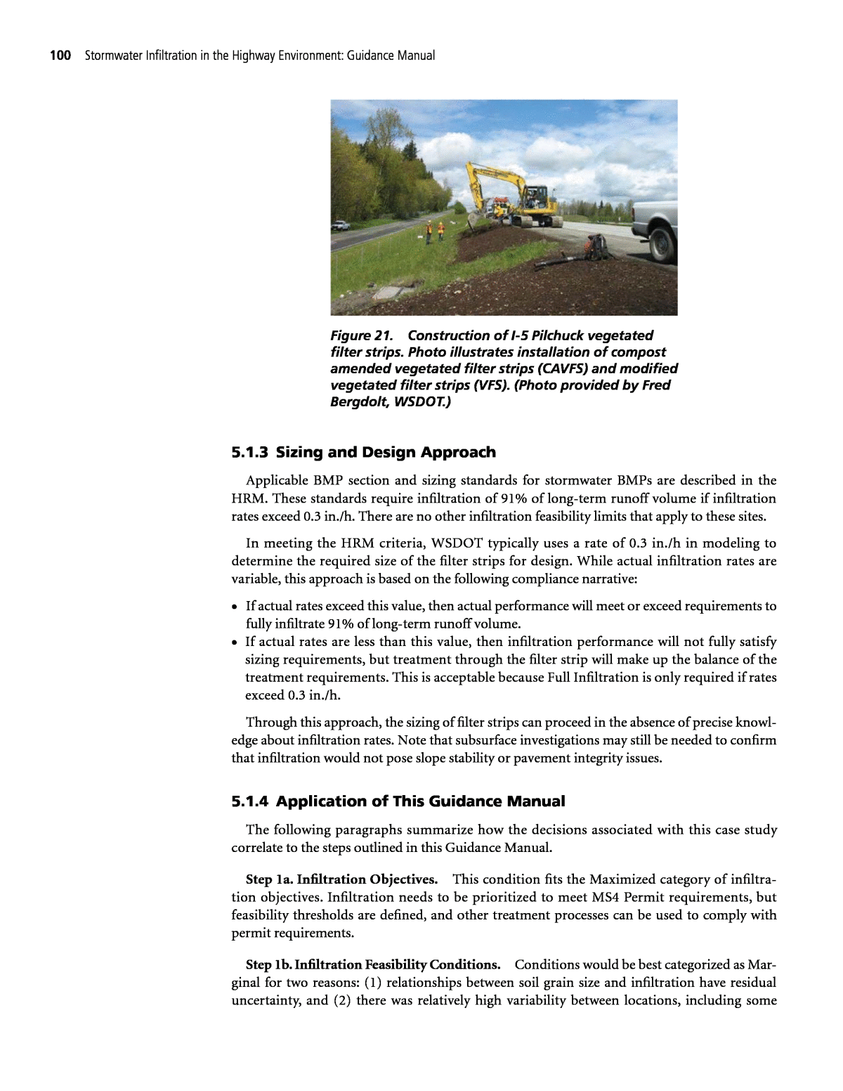
99 C H A P T E R 5 This chapter presents case studies of how local agencies and project proponents have approached selection and design of infiltration BMPs. Each case study presents the highlights of the process that was used and the decisions that were made. Additionally, each case study includes a section that summarizes how the decision-making process described in this Guidance Manual could have been applied to these cases. Alignment of the case study with the steps in this Guidance Manual is presented in the last section of each case study. 5.1 Case StudyâWSDOT Filter Strip Design Methodology WSDOT retrofitted a portion of Interstate 5 with various forms of vegetated filter strip BMPs and conducted monitoring to evaluate BMP performance. This installation also helped WSDOT comply with MS4 Permit requirements. The filter strips were designed in May 2010 and construction was completed by September 2011. This case study provides highlights of the site investigation and design process used for these systems. The investigation and design process used as part of this project are similar to other installations of vegetated filter strips on Washington State freeways. 5.1.1 Site Geometry The roadway at these filter strips locations is an elevated embankment geometry with side slope of approximately 4H:1V and embankment height of approximately 14 ft. There are three travel lanes draining to the filter strips. Figure 21 shows the construction of a typical filter strip as part of this study. 5.1.2 Site Investigation Depth to groundwater was measured using several piezometers. The groundwater was within 2 to 3 ft of the toe of embankment and approximately 12 to 14 ft below the filter strip locations. The soils underlying the sites are composed of loose to dense silty sands with gravels and silts. The geology is consistent with glacial outwash. In contrast, glacial till soils that are present in much of Washington State would be expected to be much less permeable. Grain size distribution data from borehole samples were used to estimate infiltration rate by applying the Massmann Method described in the WSDOT Highway Runoff Manual (HRM). The application of standard factors of safety per the HRM resulted in estimated infiltration rates of 0.2 to 2.2 in./h across different portions of the infiltration surface areas. Permeability also varied somewhat with depth. BMP Selection and Sizing Case Studies
100 Stormwater Infiltration in the Highway Environment: Guidance Manual 5.1.3 Sizing and Design Approach Applicable BMP section and sizing standards for stormwater BMPs are described in the HRM. These standards require infiltration of 91% of long-term runoff volume if infiltration rates exceed 0.3 in./h. There are no other infiltration feasibility limits that apply to these sites. In meeting the HRM criteria, WSDOT typically uses a rate of 0.3 in./h in modeling to determine the required size of the filter strips for design. While actual infiltration rates are variable, this approach is based on the following compliance narrative: ⢠If actual rates exceed this value, then actual performance will meet or exceed requirements to fully infiltrate 91% of long-term runoff volume. ⢠If actual rates are less than this value, then infiltration performance will not fully satisfy sizing requirements, but treatment through the filter strip will make up the balance of the treatment requirements. This is acceptable because Full Infiltration is only required if rates exceed 0.3 in./h. Through this approach, the sizing of filter strips can proceed in the absence of precise knowl- edge about infiltration rates. Note that subsurface investigations may still be needed to confirm that infiltration would not pose slope stability or pavement integrity issues. 5.1.4 Application of This Guidance Manual The following paragraphs summarize how the decisions associated with this case study correlate to the steps outlined in this Guidance Manual. Step 1a. Infiltration Objectives. This condition fits the Maximized category of infiltra- tion objectives. Infiltration needs to be prioritized to meet MS4 Permit requirements, but feasibility thresholds are defined, and other treatment processes can be used to comply with permit requirements. Step 1b. Infiltration Feasibility Conditions. Conditions would be best categorized as Mar- ginal for two reasons: (1) relationships between soil grain size and infiltration have residual uncertainty, and (2) there was relatively high variability between locations, including some Figure 21. Construction of I-5 Pilchuck vegetated filter strips. Photo illustrates installation of compost amended vegetated filter strips (CAVFS) and modified vegetated filter strips (VFS). (Photo provided by Fred Bergdolt, WSDOT.)
BMP Selection and Sizing Case Studies 101 estimates that fell below the thresholds. At any given point along the embankment, it is possible that infiltration rates would be below the 0.3 in./h threshold. However, risks associated with geotechnical and groundwater issues were not found to be limiting. Step 1c and 2. Infiltration Approach and Planning Track. This combination of objectives would put the project in Track 2aâobjectives are based on âMaximizedâ infiltration and con- ditions were marginal but not infeasible. This would justify a partial infiltration approach that maximizes but does not rely on a certain infiltration rate. According to this Guidance Manual, these are the two options: 1. Use bioretention with underdrains that maximizes infiltration and provides supplemental treatment if infiltration capacity is exceeded. 2. Use a filter strip or media filter drain that maximizes infiltration and provides positive overland flow if infiltration capacity is exceeded. Step 3. Confirmatory Investigations and BMP Selection. No confirmatory investigations were needed beyond the characterization of geotechnical issues conducted as part of planning (which were found not to be an issue). The design does not depend on a specific infiltration rate. Following the steps in this Guidance Manual, key deciding factors among potential BMP types are the following: ⢠Compatibility of BMP types with roadway geometry ⢠Relative infiltration feasibility of different parts of the highway section In deciding among the BMP options, the broad vegetated embankment areas were identi- fied as the primary opportunity for infiltration. Additionally, the depth to groundwater at the toe of slope would limit the use of infiltration swales or linear bioretention systems at the base of the embankment. Therefore, vegetated filter strips were identified as the most appro- priate infiltration BMP for this site to meet the infiltration objectives. Step 4. Design and Construction of BMPs. Sizing followed the approach described pre- viously, including assuming the underlying soils are equal to the infiltration threshold. Design followed standard WSDOT guidelines for vegetated filter strips and compost amended vegetated filter strips. WSDOT also trialed a modified filter strip design (a standard vegetated filter strip with a 3-in. compost blanket) as part of this study. WSDOT crews performed construction, which pro- vided control over means and methods. Irrigation was not needed for vegetation establishment. BMP installations in Western Washington State do not typically require irrigation. Most of the construction-phase considerations in this Guidance Manual did not apply to this project. 5.2 Case StudyâAdaptive Design Approach for a New Project A new planned community in the southwest United States has undergone intense regula- tory scrutiny and has been required to conduct rigorous consideration of infiltration as part of environmental permitting and design. While not solely a transportation project, the take- aways from this project are applicable to DOT projects, particularly new projects that propose stormwater infiltration at centralized facilities. 5.2.1 Infiltration Objectives As a condition of approval, the project adopted a stormwater management performance standard that established infiltration as the highest priority, unless it was demonstrated
102 Stormwater Infiltration in the Highway Environment: Guidance Manual to be infeasible. Biofiltration is the second priority but can require larger facilities and be more expensive to construct. This established relatively rigorous objectives for use of infiltration. 5.2.2 Early Planning Environmental clearance and layout of the project site required advanced planning efforts. Infiltration was considered as part of these efforts, including preliminary screening of infiltration feasibility based on readily available information. Available data for this step included the following: ⢠Natural Resources Conservation Service (NRCS) soil survey maps ⢠Geologic formation maps ⢠Groundwater depth contours available from the local county ⢠Mapped landslides obtained from an early geologic study of the site ⢠Preliminary bulk grading plans processed to estimate net depth of cut and fill Based on this analysis, regional BMP locations in alluvial soils were determined to be the most suitable for infiltration BMPs. This informed the overall stormwater management strategy for the projects. An example of a preliminary infiltration feasibility screening map developed as part of this effort is shown in Figure 22. Figure 22. Example preliminary infiltration feasibility screening map.
BMP Selection and Sizing Case Studies 103 The stormwater management approach described in project environmental documents was based on these findings. Additionally, project environmental documents identified the need for subsequent investigations to confirm or refine infiltration feasibility. Biofiltration was described as an alternative if infiltration was found to be infeasible. Therefore, the project retained flexibility to apply a range of infiltration approaches in the final design. However, biofiltration tends to be costlier and less favorable relative to project permitting, so there was a strong incentive to utilize infiltration wherever feasible. 5.2.3 Confirmatory Investigations Following environmental clearance, more detailed design investigations were conducted to final- ize the stormwater management plan. To confirm infiltration feasibility, geotechnical investigations were conducted as close to BMP locations as possible. Investigations included the following: ⢠Classification of soil texture and layering via borehole logs (see example borehole log in Figure 23) ⢠Investigation to a depth of 15 ft below the elevation of each BMP ⢠Borehole infiltration testing (falling head method) ⢠Investigation of groundwater level via local data sources (maps of seasonal high groundwater level) and site-specific piezometer records Investigations occurred after original environmental approvals; however, access restrictions associated with environmental resource areas limited the ability to conduct drilling and infiltration testing in all BMP locations. Additionally, one of the facilities is located more than 15 ft below existing grade and substantial excavation would be required in this area to reach the proposed grade of the facility. 5.2.4 Design and Permitting Approach Design and permitting decisions were informed by BMP-specific conditions. Facility B was determined to have reliable infiltration rates that could be reasonably confirmed via testing at the grade of the facility at three locations within the facility footprint. However, separation to the mapped high groundwater elevation was less than 10 ft and mounding was estimated to be a limitation in this area under more intense storm events. Therefore, this facility was designed as a bioretention BMP with elevated underdrains. Under most conditions, when groundwater is not near the mapped high groundwater elevation and events are less intense, infil- tration would be the dominant process in the facility. However, it was not possible to confirm the safe and reliable operation of a Full Infiltration facility at this location. Measured infiltration rates for Facility A were found to range from 4.6 to 11 in./h at two nearby locations (approximately 50 ft away). Additionally, no geologic or groundwater condi- tions were identified that would impact the amount of infiltration in the proposed location; however, because of site access limitations, the boring locations used to measure the infiltration rate could not be located within the BMP footprint. Measurements were taken via borehole methods between 20 and 30 ft belowground and primarily measured horizontal infiltration rates because of the inherent geometry of borehole infiltration methods. As a result, these estimates may not be representative of the actual full-scale vertical infiltration rates encountered after the facility is excavated to the proposed grade. Because of the uncertainty in infiltration rate and the inability to obtain a more reliable rate prior to bulk grading, an adaptable design approach was used: 1. For primary design purposes, Facility A was proposed as a bioretention BMP with elevated underdrains. This facility did not depend on infiltration but is anticipated to result in a high level of infiltration because of the inclusion of 3 ft of gravel storage below the underdrain elevation.
104 Stormwater Infiltration in the Highway Environment: Guidance Manual Figure 23. Example borehole log from borehole percolation test.
BMP Selection and Sizing Case Studies 105 2. A valve was proposed to be installed at the underdrain outlet of Facility A as a means of providing adaptability for potential design or operation revisions. 3. Project conditions of approval specify that infiltration testing be conducted after grading activities in this area expose the final grade of the facility. 4. If the factored infiltration rate measured after excavation to final grade is 2.3 in./h or greater, and design of a Full Infiltration facility is determined to be acceptable to the local permitting authority, the underdrain valve can be left closed, effectively turning Facility A into an infiltra- tion facility (preferable in this case) (see Figure 24). The threshold of 2.3 in./h was established based on the rate required to achieve the target drawdown time and achieve the target long- term performance of the facility, considering space constraints. 5. Design calculations prepared to support permit applications demonstrated that the facility would fully meet applicable sizing standards as either a Full Infiltration facility if rates are 2.3 in./h or higher or a Partial Infiltration facility with media filtration without relying on a minimum infiltration rate. This approach preserved the option to infiltrate if it was found to be feasible. The approach provided a compliance demonstration that did not depend on actual infiltration rates to achieve the overall combined infiltration/treatment volume. If infiltration is found to be clearly favorable via construction-phase testing, project proponent could consider adapting the design to a simpler infiltration basin rather than a bioretention basin with underdrains. 5.2.5 Example Application of this Guidance Manual The following paragraphs summarize how the decisions associated with this case study correlate to the steps outlined in this Guidance Manual. Step 1a. Infiltration Objectives. Due to the regulatory scrutiny and benefits of infiltra- tion, this Guidance Manual would have classified the infiltration objective as being between Stringent and Maximized. There were strong motivations to achieve infiltration, but Partial Infiltration or non-infiltration alternatives were also available if conditions were not suitable 3â Gravel Storage 2â Media 3â Ponding Valve Overflow Riser Pipe/Weir Underdrain 3ââ Choke Stone Figure 24. Conceptual cross-sectional design of Facility A showing adaptable design features.
106 Stormwater Infiltration in the Highway Environment: Guidance Manual for Full Infiltration, allowing compliance with the overall water quality requirement to be demonstrated without fully relying on infiltration. Step 1b. Preliminary Infiltration Feasibility Conditions. Based on preliminary screen- ing data available at the time of environmental clearance, both facilities appeared reasonably favorable for infiltration. Step 1c and Step 2. Infiltration Approach and Planning Track. At the planning (environmental clearance) phase, infiltration was described as the priority for these areas; however, due to the relatively large uncertainty in regional maps, environmental documents described the need for site-specific investigations and feasibility criteria that must be used to determine feasibility at those steps. This correlates to Track 1a in this Guidance Manual. Infiltration basins were identified as the tentatively selected BMP. In retrospect, the elevated groundwater condition at Facility B could potentially have been identified with more focused investigation in this area, which would have shifted this facility to Track 2a (Partial Infiltration). Step 3. Confirmatory Investigations and BMP Selection. Based on the track selected, this Guidance Manual would have called for confirmatory investigations of infiltration rates and geotechnical and groundwater issues. Where feasible, these analyses were done; however, because of access restrictions and the amount of bulk grading required, adequate confidence could not be obtained at Facility A to fully rely on infiltration. Facility A would require addi- tional confirmatory investigation of design infiltration rate as part of and during the con- struction process. This Guidance Manual would have recommended two options for Facility A based on the information obtained: 1. Use an adaptable design approach to allow infiltration to be an option supported by construction-phase testing, OR 2. Switch to Track 2a and design only a biofiltration with Partial Infiltration design. Based on an overall assessment of project objectives, the proponent elected to pursue Option 1. Confirmatory investigation at Facility B revealed previously unidentified issues with high groundwater. Because high groundwater is a limiting factor that cannot be reasonably mitigated, no further investigations were required to support BMP selection and design. Step 4. Design and Construction of BMPs. Construction of this project was in progress at the time of writing this Guidance Manual. 5.3 Case StudyâBallard Rain Gardens Lessons Learned 5.3.1 Introduction In 2010, Seattle Public Utilities (SPU) installed bioretention facilities along eight blocks of city ROW in the Ballard neighborhood. In the winter following construction, widespread failures were noted. SPU determined that approximately a third of the cells were not drain- ing, a third were draining too slowly, and a third were working as designed (Figure 25). The resolution of these issues involved removal of 40% of facilities and retrofit of 50% of facilities with underdrains. SPUâs retrospective evaluation of the planning, design, and construction process (Tackett and Colwell n.d.) revealed lessons learned that have prompted changes in the way the city plans and designs roadside infiltration BMPs.
BMP Selection and Sizing Case Studies 107 5.3.2 Key Lessons Learned SPU used this project as an opportunity to learn how to improve practices and has published articles and presentations to transfer these findings to other organizations. Examples of lessons learned included the following: ⢠Geotechnical testing was not conducted early enough in the process. The geotechnical and groundwater investigation report was prepared concurrent with the final design. While some infiltration tests indicated relatively slow infiltration rates (0.1 to 0.3 in./h) and observed fine-grained soils, there was not a feedback loop so that these findings could be incorporated into design adjustments. This was partly due to the expedited project schedule driven by funding sources. ⢠Designers should more carefully distinguish short-term tested infiltration rates from long- term design infiltration rates. Short-term tested infiltration rates can over-predict infiltra- tion, particularly in cases such as this in which some BMP locations were subject to slow draining soils and perched groundwater tables. Source: https://www.epa.gov/sites/production/files/2015-10/documents/gi_ballardproject.pdf. Figure 25. Examples of slowly draining rain gardens in the Ballard neighborhood of Seattle, Washington.
108 Stormwater Infiltration in the Highway Environment: Guidance Manual ⢠The investigation period occurred during the summer, and geotechnical recommendations did not account for groundwater mounding and perched groundwater conditions that can form in the soil types present at the sites. Recommendations conducted over an abbreviated period should have been interpreted with a greater implied uncertainty. ⢠Geotechnical engineers needed to be integrated into all phases of the project, including ini- tiating explorations earlier in planning phases and continued engagement through design development and construction. The city now relies primarily on the recommendation of geo- technical engineers to determine the need for underdrains (or capped underdrains) rather than relying solely on the design infiltration rates. ⢠Geotechnical engineers should be tasked with a more comprehensive assessment than simply infiltration rate testing. Other observations made as part of geotechnical explorations can support recommendations. ⢠When new information suggests that infiltration is unlikely or high risk, there should be a more methodical review of whether these data trigger a need for design adjustments. This should include new information obtained in the design and construction phases. ⢠Stemming from this failure, the city now puts greater emphasis on determining the need for underdrains or backup underdrains. Where measured infiltration rates are less than 0.6 in./h, the cityâs stormwater management manual requires the use of underdrains. However, underdrains may still be prescribed for sites above this threshold if data do not conclusively support infiltration. ⢠This case study also illustrated issues that can arise from constructing during the wet season. Because of schedule delays, this project was built in the middle of a relatively wet winter. This increased the risk of over-compacting the BSM (due to placement of wet BSM), increased sediment load from the tributary area, and exposed the systems to relatively heavy hydraulic loading prior to the establishment of vegetation. Overall, this case study highlights the importance of a structured process for data collection and integration to continue to improve and revise design assumptions and BMP selection decisions. It also highlights the inherent uncertainties that may continue to exist in some parameters until full-scale facilities are built. Finally, it demonstrates the value in having a built-in backup plan (resiliency), particularly in more marginal conditions. 5.3.3 Application of this Guidance Manual The following paragraphs summarize how the decisions associated with this case study cor- relate to the steps outlined in this Guidance Manual. Step 1a. Infiltration Objectives. Infiltration was being considered to reduce the volume of runoff to the cityâs combined sewer system. While infiltration was not required in this specific area, the overall drivers to reduce combined sewer overflows led to a strong incentive to pursue infiltration. Other approaches would have had less benefit. This is best classified as a Stringent objective. Step 1b. Infiltration Feasibility Conditions. Conditions were Marginal according to the classification scheme in this Guidance Manual. Soils were fine grained, and measured infiltra- tion rates were relatively low (often less than 0.3 in./h). Additionally, the short investigation period left considerable uncertainty regarding depth to groundwater and the potential for perched groundwater tables to form. Groundwater quality and geotechnical hazards did not exist, so the issues affecting this project were primarily related to infiltration rate and ground- water mounding.
BMP Selection and Sizing Case Studies 109 Step 1c and Step 2. Infiltration Approach and Planning Track. This combination of objectives would put the project in Track 1b. There was a strong motivation to achieve infil- tration, but conditions were marginal and uncertain. According to the decision tree in this Guidance Manual, these are the three options: 1. Conduct additional investigation to confirm infiltration feasibility, 2. Utilize Partial Infiltration BMPs that are less sensitive to uncertain conditions, or 3. Pursue infiltration with a built-in backup plan to address uncertainty in infiltration rates (note, this is like Option 2 but starts with underdrains capped). Step 3. Confirmatory Investigations and BMP Selection. Following the steps in this Guidance Manual would likely have resulted in selection of bioretention with underdrains (Partial Infiltration, partial biofiltration/detention). The cityâs current BMPs selection approaches (refined following these failures) would have reached this conclusion as well. In retrospect, longer-term groundwater evaluation and groundwater mounding analyses would have rejected the viability of Full Infiltration (Option 1). Options 2 and 3 would not have required further investigations and would have been less sensitive to groundwater and soil con- ditions; however, they would have been less advantageous for combined sewer overflow (CSO) control. Step 4. Design and Construction of BMPs. This Guidance Manual encourages modified project delivery such that design revisions can be made during construction if new information is encountered. SPU has identified this as a key lesson learned. More information is available at the following website: https://www.epa.gov/sites/production/ files/2015-10/documents/gi_ballardproject.pdf. 5.4 Summary These case studies present brief overviews of decision processes and lessons learned from real-world infiltration projects. These case studies also introduce how the decision structure described in this Guidance Manual could be applied to real projects. Additional case studies of infiltration BMPs, focusing on BMP failures, are included in Appendix J.
