


Below is the uncorrected machine-read text of this chapter, intended to provide our own search engines and external engines with highly rich, chapter-representative searchable text of each book. Because it is UNCORRECTED material, please consider the following text as a useful but insufficient proxy for the authoritative book pages.
243 A P P E N D I X B - D A T A B A S E D I C T I O N A R Y Database Dictionary Introduction Two master datasets were developed for NCHRP Project 17-89 â one for Static and Dynamic PTSU facilities (PTSU) and one for Bus-on-Shoulder facilities (BOS). The master datasets contains the data needed to develop predictive safety models. This document describes components of the master dataset. The data are recorded in two Excel workbooks. The PTSU workbook has the following sheets: 1. The first worksheet has data associated with each site, such as AADT, geometric data, and data related to part-time shoulder use (PTSU) facilities. It also contains crash data for each site, hourly volume profiles for each site, and PTSU status (percent time open or closed) by the hour for each site; each of these items were initially collected in other worksheets and merged prior to modeling. 2. The second worksheet has data associated with each crash, such as the time and day, crash type, crash severity, and location. 3. The third worksheet has data associated with PTSU status (i.e. shoulder open or closed to traffic). This data is also contained on the first worksheet, but is presented separately on this third worksheet in a more aggregated format The BOS workbook has the first and second sheets only. The first sections of this document describe the contents of each of these four worksheets. The final section presents a brief illustrated example of each dataset. Appendix A describes how data was collected and reduced to develop this dataset and what quality control procedures were employed by the research team. Site Data Each PTSU facility and comparison facility analyzed in this project was be segmented into sites. Sites are homogenous with respect to relevant facility characteristics and were be classified as basic freeway segments, entrance speed-change lanes, or exit speed-change lanes. Sections of freeway with weaving were classified as basic freeway segments, but flagged as having weaving so the effects of it could potentially be included in models. Sites were directional (i.e. only reflect roadway attributes and crashes for one direction of travel on the freeway). Site boundaries occur wherever one or more of the following conditions occur: ï· Change in the number of lanes ï· Change in lane width of 0.5 feet or more ï· Change in shoulder width of 2 feet or more ï· Begin or end of horizontal curve ï· Start or end of PTSU ï· Change in site type (i.e., basic freeway segment, entrance speed-change lane, or exit speed- change lane). Changes in site type and the beginning and end of horizontal curves were the most frequently-used segmentation criteria
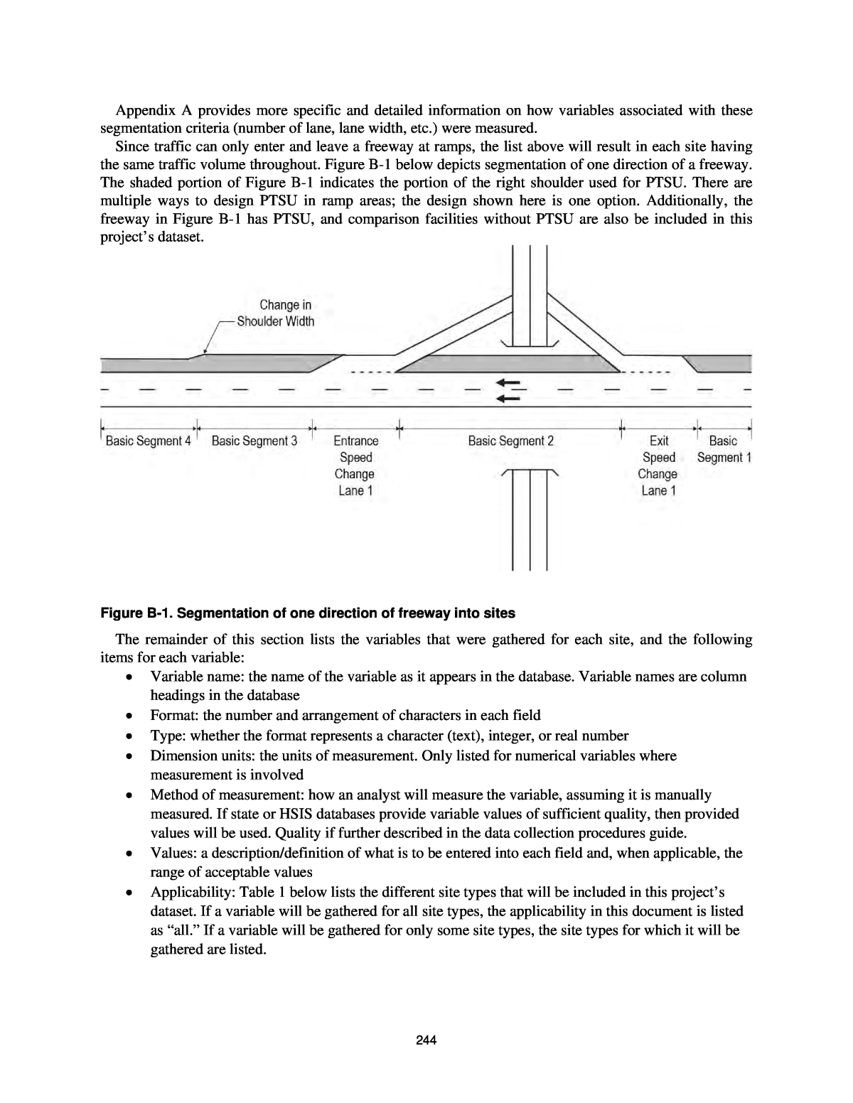
244 Appendix A provides more specific and detailed information on how variables associated with these segmentation criteria (number of lane, lane width, etc.) were measured. Since traffic can only enter and leave a freeway at ramps, the list above will result in each site having the same traffic volume throughout. Figure B-1 below depicts segmentation of one direction of a freeway. The shaded portion of Figure B-1 indicates the portion of the right shoulder used for PTSU. There are multiple ways to design PTSU in ramp areas; the design shown here is one option. Additionally, the freeway in Figure B-1 has PTSU, and comparison facilities without PTSU are also be included in this projectâs dataset. Figure B-1. Segmentation of one direction of freeway into sites The remainder of this section lists the variables that were gathered for each site, and the following items for each variable: ï· Variable name: the name of the variable as it appears in the database. Variable names are column headings in the database ï· Format: the number and arrangement of characters in each field ï· Type: whether the format represents a character (text), integer, or real number ï· Dimension units: the units of measurement. Only listed for numerical variables where measurement is involved ï· Method of measurement: how an analyst will measure the variable, assuming it is manually measured. If state or HSIS databases provide variable values of sufficient quality, then provided values will be used. Quality if further described in the data collection procedures guide. ï· Values: a description/definition of what is to be entered into each field and, when applicable, the range of acceptable values ï· Applicability: Table 1 below lists the different site types that will be included in this projectâs dataset. If a variable will be gathered for all site types, the applicability in this document is listed as âall.â If a variable will be gathered for only some site types, the site types for which it will be gathered are listed.
245 Table B-1. NCHRP Project 17-89 Site Types Basic Freeway Segment (BFS) Entrance Speed- Change Lane (EN SC Lane) Exit Speed-Change Lane (EX SC Lane) S-,D-PTSU Yes Yes Yes BOS Yes Yes Yes Comparison to S-,D-PTSU Yes Yes Yes Comparison to BOS Yes Yes Yes In the remainder of this document, the following abbreviations are used for site types: ï· S-,D-PTSU BFS = Static or Dynamic Part-time Shoulder Use Basic Freeway Segment ï· S-,D-PTSU ENSCL= Static or Dynamic Part-time Shoulder Use Entrance Speed-Change Lane ï· S-,D-PTSU EXSCL = Static or Dynamic Part-time Shoulder Use Exit Speed-Change Lane ï· BOS BFS = Bus on Shoulder Basic Freeway Segment ï· BOS ENSCL = Bus on Shoulder Entrance Speed-Change Lane ï· BOS EXSCL = Bus on Shoulder Exit Speed-Change Lane ï· S-,D-PTSUCOMP BFS = Static or Dynamic Part-time Shoulder Use Comparison Facility Basic Freeway Segment ï· S-,D-PTSUCOMP ENSCL= Static or Dynamic Part-time Shoulder Use Comparison Facility Entrance Speed-Change Lane ï· S-,D-PTSUCOMP EXSCL = Static or Dynamic Part-time Shoulder Use Comparison Facility Exit Speed-Change Lane ï· BOSCOMP BFS = Bus on Shoulder Comparison Facility Basic Freeway Segment ï· BOSCOMP ENSCL = Bus on Shoulder Comparison Facility Entrance Speed-Change Lane ï· BOSCOMP EXSCL = Bus on Shoulder Comparison Facility Exit Speed-Change Lane ï· S-,D-PTSUTRAN BFS = Static or Dynamic Part-time Shoulder Use Transition Basic Freeway Segment ï· S-,D-PTSUTRAN ENSCL = Static or Dynamic Part-time Shoulder Use Transition Entrance Speed-Change Lane ï· S-,D-PTSUTRAN EXSCL = Static or Dynamic Part-time Shoulder Use Transition Exit Speed- Change Lane Sometimes in this Appendix, the first part or the second part of the abbreviations listed above is used to refer to a group or site types. For example, âBFSâ is used to refer to S-,D-PTSU BFS; BOS BFS, S-,D- PTSUCOMP BFS, BOSCOMP BFS, S-,D-PTSUTRAN BFS collectively. S-,D-PTSUTRAN sites are further classified with the PTSUTran variable described later in this document. All S-,D-PTSUTRAN sites are at or near the beginning or end of PTSU - some are within the limits of PTSU are others are beyond it. State Variable name: State Format: XX Type: Character Method of measurement: General knowledge Values: The two letter US Postal Service abbreviation for the state
246 Applicability: All County Variable name: County Format: XXXX Type: Character Method of measurement: Agency-provided Values: Ohio DOTâs three letter abbreviation for a county in Ohio, value of ânoneâ in other states. Ohio facilities use county-based mileposts Applicability: All Route Variable name: Route Format: XXX Type: Integer Method of measurement: General knowledge Values: A stateâs numerical designation of the route. For example, I-66 will be entered as 66 and GA 400 will be entered as 400 Applicability: All Direction Variable name: Direction Format: XXX Type: Character Method of measurement: Agency-provided and/or Google Streetview Values: INC for increasing milepost direction (northbound or eastbound) or DEC for decreasing milepost direction (southbound or westbound) Applicability: All Site Type â Shoulder Usage (BOS, S-PTSU, D-PTSU, BOS Comparison, S-PTSU Comparison, D-PTSU Comparison, S-PTSU Transition, D-PTSU Transition) Variable name: SitePTSU Format: XXXXXXXXXXX Type: Character Method of measurement: General knowledge Values: Acceptable values are BOS, S-PTSU, D-PTSU, BOSCOMP, S-PTSUCOMP, D- PTSUCOMP, defined as follows: ï· BOS = Bus on Shoulder ï· S-PTSU = Static Part-time Shoulder Use ï· D-PTSU = Dynamic Part-time Shoulder Use ï· S-PTSUTRAN = Static Part-time Shoulder Use transition ï· D-PTSUTRAN = Dynamic Part-time Shoulder Use transition ï· BOSCOMP = facility with no PTSU being compared to BOS facilities ï· S-PTSUCOMP = facility with no PTSU being compared to S-PTSU facilities ï· D-PTSUCOMP = facility with no PTSU being compared to D-PTSU facilities
247 The three comparison site types are indistinguishable from one another by inspection alone; the differentiation occurs because each comparison site will be located in the same metropolitan area as a PTSU site. A comparison site located in the same metropolitan area as a BOS site, for example, will be designated as a BOS comparison site. Transition sites are upstream of the start of PTSU, downstream of the end of PTSU, or the tapered sections into and out of PTSU. Facilities that started at S-PTSU but were converted to D-PTSU during the study period are classified as S-PTSU and a value in ConversionDate indicates the facility was converted to D-PTSU Applicability: All Site Type - Geometric Variable name: SiteGeo Format: XXX or XXXXX Type: Character Method of measurement: Assigned by team based on observation in Google Earth Values: The geometric site type. Acceptable values are BFS (for Basic Freeway Segment), ENSCL (for Entrance Speed-Change Lane), and EXSCL (for Exit Speed-Change Lane). Examples of the three site types are shown in Figure 1. Applicability: All Number of Lanes Variable name: NumLanes Format: X Type: Integer Method of measurement: Observed in Google Earth Values: The number of general-purpose through lanes on the freeway in the siteâs direction of travel. Managed lanes (such as HOV lanes) are included. The ManagedLane variable is used to indicate if any of the lanes tabulated here are managed. Auxiliary lanes associated with a weaving section are not included unless the length of the weaving section exceeds 0.85 miles (4,500 feet). Speed-change lanes associated with merging and diverging ramps are not included unless they exceed 0.30 miles (1,600 feet). If an auxiliary lane exceeds 0.85 miles or a speed-change lane exceeds 0.30 miles, then it is included in the counting of the number of lanes and the site is classified as a basic freeway segment (not speed-change lane) without weaving. Applicability: All Lane Add or Drop Variable name: LaneAddDrop Format: XXXX Type: Character Method of measurement: Observed in Google Earth Values: Add, Drop, or None Applicability: All Managed Lanes Variable name: ManagedLanes Format: X Type: Integer
248 Method of measurement: Observed in Google Earth Values: Indicates the number of managed lanes, such as high occupancy vehicle (HOV) or high occupancy toll (HOT) lanes, present. Zero indicates no managed lanes are present Applicability: All Zipper Lane Variable name: Zipper Format: X Type: Integer Method of measurement: Observed in Google Earth Values: 0 or 1. 1 indicates the presence of zipper lane, defined for this project as a lane on the opposite direction of the freeway that is reversed through use of a moveable barrier for some hours of the day to serve traffic traveling in the direction of study. By this definition, the only facility with a zipper lane in Project 17-89 in the increasing direction of Interstate H1 in Hawaii. Volume of the zipper lane, crashes within it, and geometrics are not included in this projectâs dataset, but this variable is still used to indicate which segments have an adjacent zipper lane Applicability: All Speed Limit Variable name: SpeedLimit Format: XX Type: Integer Dimensional Units: Miles per hour Method of measurement: Agency-provided. Values: The posted speed limit on the freeway. Only included for BOS and BOSCOMP databases because some S-,D-PTSU states were unable to provide speed limit data Applicability: BOS, BOSCOMP Opening Date Variable name: Opening Format: YYYY-MM-DD Type: Integer-Integer-Integer Method of measurement: General knowledge for older facilities, agency-provided data for newer facilities where the opening date may be as recent as within one year of the start data collection period. Values: The four-digit year, two-digit month, and two-digit day that the PTSU facility opened. If the opening date is unknown and more than one year prior to the crash data period used for this project, the date entered here will be January 1 of the year the facility is best believed to have opened. If the opening date is less than one year prior the crash data period, the approximate opening date will be enterer here and the uncertainty of the data will be captured in the OpeningKnown field. This variable will not be recorded for comparison facilities because this project will only use comparison facilities that have been open for more than one year prior to the start of the crash data period. Applicability: S-,D-PTSU This variable is not included in the BOS database
249 Opening Date Known Variable name: OpeningKnown Format: XXXXX Type: Boolean Method of measurement: Assigned by research team based on confidence in prior variable Values: If the opening date is known with certainty or is more than 1 year prior to the start of the crash data analysis period, this variable will be set to TRUE. Acceptable values are True and False Applicability: S-,D-PTSU This variable is not included in the BOS database Conversion Date Variable name: Conversion Format: YYYY-MM-DD Type: Integer-Integer-Integer Method of measurement: Agency-provided. Values: The four digit year, two digit month, and two digit day that an S-PTSU facility was converted to a D-PTSU facility. Applicability: S-PTSU This variable is not included in the BOS database Conversion Date Known Variable name: ConversionKnown Format: XXXXX Type: Boolean Method of measurement: Assigned by research team based on confidence in prior variable Values: If the conversion date is known with certainty or is more than 1 year prior to the start of the crash data analysis period, this variable will be set to TRUE. Acceptable values are True and False Applicability: S-PTSU This variable is not included in the BOS database Site Identification Number Variable name: SiteID Format: SS-RRR-XXX Type: Character-Integer-Character-Integer Method of measurement: Assigned by research team Values: SS is equal to the value of the variable State, RRR is equal to the value of the variable Route, and XXX is a unique number assigned to each site generally beginning with 001 for each SS-RRR combination and restarting with 001 for each new SS-RRR combination. Some groups of sites were assigned RRR values starting with 100 or 200. Applicability: All Starting Coordinates Variable name: StartCoord Format: DD°MMâSS.SSâN,-DDD°MMâSS.SSâW Type: integer°integerâreal numberâN,-integer°integerâreal numberâW Method of measurement: Obtained from Google Earth
250 Dimensional Units: Degree, minutes, and seconds of latitude and longitude Values: The first portion of this field, prior to the comma, represents the degrees, minutes, and seconds of latitude north of the equator of a siteâs starting point. The second portion of the field, after the comma, represents the degrees, minutes, and seconds of longitude west of the Prime Meridian of a siteâs starting point. Values will be obtained from pins dropped in Google Earth. Applicability: All Ending Coordinates Variable name: EndCoord Format: DD°MMâSS.SSâN,-DDD°MMâSS.SSâW Type: integer°integerâreal numberâN,-integer°integerâreal numberâW Method of measurement: Obtained from Google Earth Dimensional Units: Degree, minutes, and seconds of latitude and longitude Values: The first portion of this field, prior to the comma, represents the degrees, minutes, and seconds of latitude north of the equator of a siteâs starting point. The second portion of the field, after the comma, represents the degrees, minutes, and seconds of longitude west of the Prime Meridian of a siteâs starting point. Values will be obtained from pins dropped in Google Earth. Applicability: All Beginning Milepost Variable name: BeginMilepost Format: X.XXX Type: Real Number Dimensional Units: Miles Method of measurement: Computed with macros from pins dropped in Google Earth, some of which are associated with a GIS file containing milepost data. If such GIS data is not available, and analyst will manually assign the mileposts based on milemakers visible in Google Streetview or the mileposts of geocoded crashes. Different milepost systems are used for the increasing and decreasing milepost directions of I-66 and I-264 in Virginia based on VDOT data. Other freeways have the same milepost system for both directions. Values: The milepost in a stateâs route inventory data corresponding to the start of the site. If a state provides milepost data in GIS format, the GIS file will be imported to Google Earth to enable a visual comparison to BeginCoord and assignment of a BeginMillepost value based on this comparison. Applicability: All End Milepost Variable name: EndMilepost Format: X.XXX Type: Real Number Dimensional Units: Miles Method of measurement: Computed with macros from pins dropped in Google Earth, some of which are associated with a GIS file containing milepost data. If such GIS data is not available, and analyst will manually assign the mileposts based on milemakers visible in Google Streetview or the mileposts of geocoded crashes. Different milepost systems are used for the increasing and decreasing milepost directions of I-66 and I-264 in Virginia based on VDOT data. Other freeways have the same milepost system for both directions.
251 Values: The milepost in a stateâs route inventory data corresponding to the end of the site. If a state provides milepost data in GIS format, the GIS file will be imported to Google Earth to enable a visual comparison to EndCoord and assignment of an EndMillepost value based on this comparison. Applicability: All Target Variable name: Target Format: X Type: Integer Values: 1 for every segment, this variable is needed for an MS Excel macro being reused from NCHRP Project 17-45 to run properly Applicability: All Photo Date Variable name: PhotoDate Format: MM-DD-YYYY Type: Integer-Integer-Integer Method of measurement: Viewed by the research team in Google Earth Values: The two digit month, two digit day, and four digit year of the Google Earth historical aerial used for data collection Applicability: All Problem Flag Variable name: ProblemFlag Format: X Type: Integer Method of measurement: Assigned by the research team Values: Numeric codes were assigned throughout the data collection process to indicate sites that may not have been appropriate for analysis due to issues such as long-term construction. The principal investigator ultimately assessed each site and removed the site if appropriate. Only sites with a value of 1, which indicates no problem, remain in the database Applicability: All Length of Segment Variable name: Length Format: X.XXXX Type: Real Number Dimensional Units: Miles Method of measurement: Computed with arithmetic from BeginMilepost and EndMilepost Values: The distance between Start and End in miles, measured along the left edge of the travelled way of the freeway Applicability: All Length of Speed Change Lane Variable name: SCLaneLength
252 Format: X.XXXX Type: Real Number Dimensional Units: Miles Method of measurement: Computed by summing the Length values of each segment in a specific speed-change lane. Often a speed change lane consists of only one segment and SCLaneLength equals Length Values: The distance between the gore point and the taper point of a speed change lane, measured along the left edge of the travelled way of the freeway Applicability: ENSCL, EXSCL Number of Lanes on Ramp Variable name: RampLanes Format: X Type: Integer Method of measurement: Observed in Google Earth Applicability: All Speed Change Lane Type, Lane 1 Variable name: SCLType1 Format: X Type: Character Method of measurement: Classification assigned by research team Values: The codes for this variable have the following meanings ï· A â PTSU adds from an entrance speed-change lane or drops onto an exit speed- change lane ï· B â PTSU is present before and after the speed-change lane. When PTSU is open, parallel style ramps effectively become taper-style ramps because through shoulder traffic uses the speed-change lane ï· C â PTSU is between the rightmost general purpose lane and a parallel-style speed change lane. ï· D â PTSU starts or ends at the gore by a general purpose lane converting to PTSU ï· E â PTSU starts or ends at the gore by PTSU adding from or dropping onto the ramp. For two-lane ramps, this variable is used for the inner speed-change lane Applicability: S-,D-PTSU ENSCL. Used only for right-side PTSU This variable is not included in the BOS database Speed Change Lane Type, Lane 2 Variable name: SCLType2 Format: X Type: Character Method of measurement: Classification assigned by research team Values: The codes for this variable have the following meanings ï· A â PTSU adds from an entrance speed-change lane or drops onto an exit speed- change lane ï· B â PTSU is present before and after the speed-change lane. When PTSU is open, parallel style ramps effectively become taper-style ramps because through shoulder traffic uses the speed-change lane
253 ï· C â PTSU is between the rightmost general purpose lane and a parallel-style speed change lane. ï· D â PTSU starts or ends at the gore by a general purpose lane converting to PTSU ï· E â PTSU starts or ends at the gore by PTSU adding from or dropping onto the ramp. For two-lane ramps, this variable is used for the outer speed-change lane. This variable is not used for one-lane ramps Applicability: S-,D-PTSU ENSCL. Used only for right side PTSU This variable is not included in the BOS database PTSU Transition Segment Variable name: PTSUTran Format: XXXXX Type: Character Method of measurement: Observed in Google Earth Values: ï· Upstream â the segment is immediately prior to the start of PTSU ï· StartTaper ï· StartFFW - The first PTSU segment at which the shoulder is full width (i.e. beyond the taper into PTSU) ï· EndTaper ï· EndLFW - the last PTSU segment at which the shoulder is full width (i.e. prior to the taper out of PTSU) ï· Downstream ï· Between - A segment that is both downstream and upstream of PTSU Applicability: S-,D-PTSUTRAN This variable is not included in the BOS database Figure B-2. Definitions of PTSU Transition Segment, Start Areas if Taper Present Figure B-3. Definitions of PTSU Transition Segment, Start Areas if Taper Not Present
254 Figure B-4. Definitions of PTSU Transition Segment, End Areas if Taper Present Figure B-5. Definitions of PTSU Transition Segment, End Areas if Taper Not Present Figure B-6. Definitions of PTSU Transition Segment, Between Notes Variable name: Notes Format: Any Type: Any Values: Any. This field is used for the project team to record any special comments for a given site Applicability: All Starting Day Variable name: StartDay Format: YYYY-MM-DD Type: Integer-Integer-Integer Method of measurement: Assigned by team based on opening day of facility and years of crash data used for analysis Values: The four-digit year, two-digit month, and two-digit day that is the first day of the analysis and modeling period for this project. This will typically be January 1 of a given year, except for newer PTSU facilities that opened mid-year Applicability: All Ending Day Variable name: EndDay Format: YYYY-MM-DD Type: Integer-Integer-Integer
255 Method of measurement: Assigned by team based on opening day of facility and years of crash data used for analysis Values: The four-digit year, two-digit month, and two-digit day that is the last day of the analysis and modeling period for this project. This will typically be December 31 of a year that is five years after the year of StartDay. The intent is to develop models using five years of crash data when possible Applicability: All AADT, For Each Year Variable name: AADT2011 through AADT2018 (8 unique variables) Format: XXXXXX Type: Integer Values: The directional average annual daily traffic for the site for a given calendar year (January to December). Only years being used for analysis are populated. The research team will acquire a stateâs âofficialâ AADT values whenever possible instead of manually computing this from traffic counts. Applicability: All Length of Curve Variable name: CurveLen Format: X.XXX Type: Real Number Dimensional Units: Miles Method of measurement: Computed with macros from pins dropped in Google Earth Values: The length of a horizontal curve in miles from the point of curvature (PC) to the point of tangent (PT), measured along the left edge of the travelled way of the freeway. References to âcurvesâ in the remainder of this document refer to horizontal curves. The entire length of curve is measured, even if a portion of the curve is outside of the limits to the site. If the curve has spiral transitions, the length is measured from the âeffectiveâ PC to the âeffectiveâ PT; this will be further described if any facilities included in this projectâs dataset are found to have spiral transitions. Applicability: All Radius of Curve Variable name: CurveRad Format: XXX Type: Integer Dimensional Units: Feet Method of measurement: Computed with macros from pins dropped in Google Earth Values: The radius of a curve in feet. Applicability: All Length of Curve in segment Variable name: CurveLenInSeg Format: X.XXX Type: Real Number Dimensional Units: Miles Method of measurement: Computed with arithmetic from other variables
256 Values: The length of a curve that is within the limits of analysis site. If a curve is completely within the limits of the analysis site, CurveLenInSeg is equal to CurveLen. If only a portion of a curve is within the limits of the analysis site, CurveLenInSeg is less than CurveLen and equal to Length. Applicability: All Lane Width Variable name: LaneWidth Format: X.X Type: Real Number Dimensional Units: Feet Method of measurement: Computed with macros from pins dropped in Google Earth Values: The total width of full-time through lanes (edge line to edge line), divided by the number lanes and measured in feet. âFull-time through lanesâ include general purpose lanes and managed lanes. Portions of the shoulder use for travel, Speed Change Lanes, and Auxiliary Lanes are excluded from this calculation. Applicability: All Right Shoulder Width Variable name: RShoulder Format: X.X Type: Real Number Dimensional Units: Feet Method of measurement: Computed with macros from pins dropped in Google Earth Values: The width of the right shoulder in feet, from edge line to edge of pavement. If right side BOS is present, this width includes both the portion of the shoulder used for travel by buses. If right side S- PTSU or D-PTSU is present, this width does not include the portion of the shoulder use for travel and only includes the âshoulder beyond the shoulderâ (the portion of the shoulder beyond the second edge line). All S-PTSU and D-PTSU sites used in Project 17-89 had second edge lines. Applicability: All Left Shoulder Width Variable name: LShoulder Format: X.X Type: Real Number Dimensional Units: Feet Method of measurement: The width of the left shoulder in feet, from edge line to edge of pavement. If left side BOS is present, this width includes both the portion of the shoulder used for travel by buses. If left side S-PTSU or D-PTSU is present, this width does not include the portion of the shoulder use for travel and only includes the âshoulder beyond the shoulderâ (the portion of the shoulder beyond the second edge line). All S-PTSU and D-PTSU sites used in Project 17-89 had second edge lines. Applicability: All Width of Right Shoulder Used for Travel Variable name: RShoulderPTSU Format: X.X Type: Real Number
257 Dimensional Units: Feet Method of measurement: Computed with macros from pins dropped in Google Earth Values: The width in feet of the portion of the right shoulder used for PTSU. If the shoulder does not have a second edge line or it located at edge of pavement, RShoulderPTSU is equal to RShoulder. If the right shoulder is not used for PTSU, RShoulderPTSU is equal to 0. Applicability: S-,D-PTSU This variable is not included in the BOS database Width of Left Shoulder Used for Travel Variable name: LShoulderPTSU Format: X.X Type: Real Number Dimensional Units: Feet Method of measurement: Computed with macros from pins dropped in Google Earth Values: The width in feet of the portion of the left shoulder used for PTSU. If the shoulder does not have a second edge line or it is located at edge of pavement, LShoulderPTSU is equal to LShoulder. If the left shoulder is not used for PTSU, RShoulderPTSU is equal to 0. Applicability: S-,D-PTSU This variable is not included in the BOS database Second Right Edge Line Variable name: 2REdgeLine Format: XXXX Type: Boolean Method of measurement: Observed in Google Earth Values: True if there is a second edge line that separates the portion of the shoulder used for PTSU from an outer portion of the shoulder never used for travel. Applicability: S-,D-PTSU This variable is not included in the BOS database Second Left Edge Line Variable name: 2LEdgeLine Format: XXXX Type: Boolean Method of measurement: Observed in Google Earth Values: True if there is a second edge line that separates the portion of the shoulder used for PTSU from an inner portion of the shoulder never used for travel. Applicability: S-,D-PTSU This variable is not included in the BOS database Length of Right Side Rumble Strips Variable name: RRumble Format: XXX Type: Real Number Dimensional Units: Feet
258 Method of measurement: Measurements with ruler tool in Google Earth Values: The length within a segment that rumble strips are present on the right shoulder. Applicability: All Length of Left Side Rumble Strips Variable name: LRumble Format: XXX Type: Real Number Dimensional Units: Feet Method of measurement: Measurements with ruler tool in Google Earth Values: The length within a segment that rumble strips are present on the left shoulder. Applicability: All Roadside Barrier Length Variable name: RoadsideLength Format: X.XXX Type: Real Number Dimensional Units: Feet Method of measurement: Computed with macros from pins dropped in Google Earth Value: The sum of the length of all roadside barriers in segment Applicability: All Roadside Barrier offset Variable name: RoadsideOffset Format: XX Type: Real Number Dimensional Units: Feet Method of measurement: Computed with macros from pins dropped in Google Earth Value: The average distance from the edge of travelled way (including the portion of a shoulder used for S-,D-PTSU but not the portion of a shoulder used for BOS) to the face of roadside barriers in the segment Applicability: All Median Plus Inside Shoulder Width Variable name: MedianPISW Format: XX.X Type: Real Number Dimensional Units: Feet Method of measurement: Computed with macros from pins dropped in Google Earth Values: The distance from the edge of the travelled way in the increasing direction of travel to the edge of the travelled way in the decreasing direction of travel. The travelled way includes the portion of a shoulder used for left side S-,D-PTSU but not the portion of a shoulder used for left side BOS Applicability: All. This variable is collected for all sites whether the median barrier is continuous or not
259 Median Width Variable name: MedianWidth Format: XX.X Type: Real Number Dimensional Units: Feet Method of measurement: Computed with macros from pins dropped in Google Earth Values: The distance from the inside edge of the inside shoulder in the increasing direction of travel to the inside edge of the inside shoulder in the decreasing direction of travel. This width does not include the shoulder itself Applicability: All. This variable is collected for all sites whether the median barrier is continuous or not Median Barrier Width Variable name: MedianBarWidth Format: XX.X Type: Real Number Dimensional Units: Feet Method of measurement: Computed with macros from pins dropped in Google Earth Values: The distance from the face of the median barrier in the increasing direction of travel to the face of the median barrier in the decreasing direction of travel Applicability: All. This variable is only collected for sites where the median barrier is continuous and less than 30 feet from the edge of the travelled way. The travelled way includes the portion of a shoulder used for left side S-,D-PTSU but not the portion of a shoulder used for left side BOS Median Type Variable name: MedianType Format: XXXXXXXXXXXXX Type: Character Method of measurement: Observed in Google Earth, verified in Streetview if necessary Values: Acceptable values are âcable barrierâ, âguardrail barrierâ, âconcrete barrierâ, and âunobstructedâ. A barrier that is present but 30 or more feet from the edge of the travelled way is considered to be unobstructed. The travelled way includes the portion of a shoulder used for left side S-,D-PTSU but not the portion of a shoulder used for left side BOS. If a portion of a site is unobstructed and another portion of a side has a cable barrier, guardrail barrier, or concrete barrier, the value of MedianType is cable barrierâ, âguardrail barrierâ, âor concrete barrierâ. The dataset did not include sites with large numbers of unprotected median obstructions, such as forested areas Applicability: All. This variable is collected for all sites whether the median barrier is continuous or not Median Offset Variable name: MedianOffset Format: XX.X Type: Real Number Dimensional Units: Feet Method of measurement: The average distance from the edge of travelled way to the face of a continuous median barrier in the direction of study (increasing or decreasing). The travelled way
260 includes the portion of a shoulder used for left side S-,D-PTSU but not the portion of a shoulder used for left side BOS. Applicability: All. This variable is only collected for sites where the median barrier is continuous Median Barrier Length Variable name: MedianBarLen Format: XXX Type: Integer Dimensional Units: Feet Method of measurement: Computed with macros from pins dropped in Google Earth Values: The length of non-continuous median barrier in a site. If multiple pieces are present, this value of this variable is the sum of their length Applicability: All. This variable is collected for sites where a discontinuous median barrier is present. These may be sites that have no other median barriers (such as a grass median) or sites that have a continuous median barrier but also have a short piece of discontinuous barrier present in front of the continuous barrier. Median Barrier Offset Variable name: MedianBarOffset Format: XXX Type: Integer Dimensional Units: Feet Method of measurement: Computed with macros from pins dropped in Google Earth. The average distance from the edge of travelled way to the face of a discontinuous median barrier in the direction of study (increasing or decreasing). The travelled way includes the portion of a shoulder used for left side S-,D-PTSU but not the portion of a shoulder used for left side BOS. Applicability: All. This variable is only collected for sites where the median barrier is discontinuous Weaving Section Variable name: Weaving Format: XXXXXXX Type: Text Method of measurement: Observed in Google Earth Values: Acceptable values are âOne-Sidedâ, or âNoneâ. Two-sided weaving sections, by definition, have a left hand ramp and were excluded from analysis in this project. The Highway Capacity Manual (HCM) 6th Edition defines these types of weaving sections in greater detail. Length of weaving sections was limited to 4500â, consistent with older editions of the HCM. The 6th Edition of the HCM has a variable maximum length based upon traffic volumes, and volumes were not available for all weaving sites. Applicability: All
261 Dimensions illustrate measurement of the following variables: 1. Right Shoulder Width 2. Left Shoulder Width 3. Width of Right Shoulder Used for Travel 4. Width of Left Shoulder Used for Travel 5. Median Plus Inside Shoulder Width 6. Median Width 7. Median Barrier Width (for sites with continuous median barriers only) 8. Median Offset (for sites with continuous median barriers only) Figure B-7. Definitions of Cross Sectional Measurements
262 Weaving Length Variable name: WeavingLength Format: XXXX Type: Integer Method of measurement: Manually measured in Google Earth with Ruler Tool Values: The length of the weaving section in feet, measured from gore point to gore point, where a gore point is defined as the location where the edge line of the freeway and edge line of the ramp are 2 feet apart Applicability: All segments where âWeavingâ = âOne-Sidedâ Note: A number of variables that follow refer to upstream and downstream ramps, as well as ramps within a site (for speed change lane sites). This project only collected data for right-side ramps. Only one left-side ramp was identified on the study corridors, and sites in the vicinity of it were excluded from the dataset. Distance to Nearest Upstream Entrance Ramp Variable name: UpstreamENdist Format: X.XXX Type: Real Number Dimensional Units: Miles Method of measurement: Computed with macros from pins dropped in Google Earth Values: Distance in miles to the nearest upstream entrance ramp. The distance is measured along the right edge of the travelled way from the start of the site back (against traffic) to the gore point of the ramp. The gore point is the location where the solid white edge lines of the ramp and the freeway are 2.0 feet apart. Applicability: All AADT of Nearest Upstream Entrance Ramp, For Each Year Variable name: UpstreamENAADT2011 through UpstreamENAADT2018 Format: XXXXX Type: Integer Method of measurement: Provided by agency Values: The average annual daily traffic for the upstream ramp for a given calendar year (January to December). UpstreamENAADT1 will correspond to the year of StartDay, and UpstreamENAADT2 through UpstreamENAADT5 will correspond to years that follow sequentially. If the upstream ramp was outside of the study area and clearly more than 0.5 miles away, volumes are sometimes entered into database as 99. Consistent with current HSM freeway model, ramps more than 0.5 miles away are not anticipated to be included in models. Applicability: All Transition Length Variable name: TranLength Format: XXXX Type: Real Number Dimensional Units: Miles Method of measurement: Measured in Google Earth with Ruler Tool
263 Values: R and L. Length of a transition segment that is with 800â or less from the start or end of PTSU. Maximum length is 0.152 Applicability: S-,D-PTSUTRAN This variable is not included in the BOS database Distance to Nearest Downstream Exit Ramp Variable name: DownstreamEXdist Format: X.XXX Type: Real Number Dimensional Units: Miles Method of measurement: Computed with macros from pins dropped in Google Earth Values: Distance in miles to the nearest downstream exit ramp. The distance is measured along the right edge of the travelled way from the end of the site forward to the gore point of the ramp. The gore point is the location where the solid white edge lines of the ramp and the freeway are 2.0 feet apart. Applicability: All AADT of Nearest Downstream Exit Ramp, For Each Year Variable name: DownstreamEXAADT2011 through DownstreamEXAADT2018 Format: XXXXX Type: Integer Method of measurement: Provided by agency Values: The average annual daily traffic for the downstream exit ramp for a given calendar year (January to December). Only years being used for the analysis are populated. If the downstream ramp was outside of the study area and clearly more than 0.5 miles away, volumes are sometimes entered into database as 99. Consistent with current HSM freeway model, ramps more than 0.5 miles away are not anticipated to be included in models. Applicability: BFS. AADT of Entrance Ramp, For Each Year Variable name: ENAADT2011 through ENAADT2018 Format: XXXXX Type: Integer Method of measurement: Provided by agency Values: The average annual daily traffic for the entrance ramp for a given calendar year (January to December). Only years being used for the analysis are populated. Applicability: ENSCL, BFS (when entrance ramp present) AADT of Exit Ramp, For Each Year Variable name: EXAADT2011 through EXAADT2018 Format: XXXXX Type: Integer Method of measurement: Provided by agency Values: The average annual daily traffic for the entrance ramp for a given calendar year (January to December). Only years being used for the analysis are populated. Applicability: EXSCL, BFS (when entrance ramp present)
264 Distance to Upstream Start of PTSU Variable name: DistToStart Format: X.XX Type: Real Number Dimensional Units: Miles Method of measurement: Computed with arithmetic from other variables Values: The upstream distance from the start of the segment to the start of PTSU, measured along the left edge of the travelled way of the freeway. The distance is measured to the start of the overall PTSU facility, even if there are short intermittent sections where shoulder traffic uses a permanent auxiliary or speed change lane or is not present through an interchange. The start of the PTSU facility is defined as the start of the taper into PTSU. Applicability: S-,D-PTSU This variable is not included in the BOS database Distance to Downstream to End of PTSU Variable name: DistToEnd Format: X.XX Type: Real Number Dimensional Units: Miles Method of measurement: Computed with arithmetic from other variables Values: The downstream distance from the end of the segment to the end of PTSU, measured along the left edge of the travelled way of the freeway. The distance is measured to the end of the overall PTSU facility, even if there are short intermittent sections where shoulder traffic uses a permanent auxiliary or speed change lane or is not present through an interchange. The end of the PTSU facility is defined as the end of the taper out of PTSU Applicability: S-,D-PTSU This variable is not included in the BOS database Length of Turnout Variable name: Turnout Format: XXX Type: Integer Dimensional Units: Feet Method of measurement: Measured with the ruler tool in Google Earth Values: Turnouts are designed areas beyond the shoulder intended as a refuge for disabled vehicles. This is the length of the turnout within the segment from the start taper to the end taper. Applicability: S-,D-PTSU BFS This variable is not included in the BOS database PTSU Side Variable name: PTSUside Format: X Type: Character Method of measurement: General knowledge and Google Earth observations Values: R and L. Indicates which shoulder is used for PTSU Applicability: S-,D-PTSU; BOS
265 Sign Type Variable name: SignType Format: XXXXXX Type: Character Method of measurement: General knowledge Values: Indicates if an S-PTSU facility has static or dynamic signs Applicability: S-PTSU This variable is not included in the BOS database The next group of columns in the site data worksheet contain average values for each of the AADT variables (the siteâs AADT, downstream exit ramp AADT, etc.) and the number of days in each year studied, which is used to compute the average AADTs. Then, the next groups of columns contain crash frequencies for total crashes and various types and severities. The BOS database ends at this point. The PTSU database has two more groups of columns: hourly volume data and the hourly PTSU status (open/closed). Variables included in these last two groups of columns are described below. Hourly volume, in general, is less reliable than AADT. Hourly volumes are collected by different types of equipment with different accuracies, and may reflect long-term average values or a single 24 hour period (such as a tube count) that does not reflect seasonal variation or day-to-day variation. The research team made use of data from automated traffic recorders (ATRs) when possible. To mitigate these issues, the research team converted hourly volumes to proportions of daily volume (i.e. the sum of the 24 proportions is 1.00 for the weekday, Saturday, and Sunday). Proportions were applied to the more-reliable AADT values to generate âannualâ hourly volumes for each analysis year before they were used for modeling purposes. Year of Weekday Hourly Volume Data Variable name: WeekdayHourlyYear Format: XXXX Type: Integer Values: The year that weekday hourly volume data represents. Applicability: S-,D-PTSU Weekday Distance to Count Variable name: WeekdayDistToCount Format: X.XX Type: Real Number Dimensional Units: Miles Values: The distance in miles between BeginMilepost and the location at which the hourly count used to develop the weekday hourly volume profile for the site was located. This variable will provide an indication of the confidence in the hourly volumes. Applicability: S-,D-PTSU Weekday Hourly Volume Proportion, for each hour of the day Variable name: WeekdayVol0 through WeekdayVol23 (24 unique variables) Format: XXXX Type: Integer
266 Values: The proportion of a typical weekdayâs (Tuesday through Thursday) volume during each hour of the typical weekday within the year of HourlyYear. Applicability: S-,D-PTSU Year of Saturday Hourly Volume Data Variable name: SatHourlyYear Format: XXXX Type: Integer Values: The year that Saturday hourly volume data represents. Applicability: S-,D-PTSU Saturday Distance to Count Variable name: SatDistToCount Format: X.XX Type: Real Number Dimensional Units: Miles Values: The distance in miles between BeginMilepost and the location at which the Saturday hourly count used to develop the weekend hourly volume profile for the site was located. This variable will provide an indication of the confidence in the hourly volumes. Applicability: S-,D-PTSU Year of Sunday Hourly Volume Data Variable name: SunHourlyYear Format: XXXX Type: Integer Values: The year that Sunday hourly volume data represents. Applicability: S-,D-PTSU Sunday Distance to Count Variable name: SunDistToCount Format: X.XX Type: Real Number Dimensional Units: Miles Values: The distance in miles between BeginMilepost and the location at which the Sunday hourly count used to develop the weekend hourly volume profile for the site was located. This variable will provide an indication of the confidence in the hourly volumes. Applicability: S-,D-PTSU ATR Milepost Variable name: ATRMilepost Format: X.XXX Type: Real Number Values: The milepost of the automated traffic recorder (ATR) used to develop the hourly volume profiles Applicability: S-,D-PTSU
267 Weekend Hourly Volume Proportion, for each hour of the day Variable name: WeekendVol0 through WeekendVol23 (24 unique variables) Format: XXXX Type: Integer Values: The proportion of a typical weekend (Saturday and Sunday) volume during each hour of the typical weekend within the year of HourlyYear. Applicability: S-,D-PTSU Weekday PTSU Operation, for each hour of the day Variable name: WeekdayOps0 through WeekdayOpsVol23 (24 unique variables) Format: XXXX Type: Real Number Values: The proportion of each weekday hour that PTSU was open during the study period. 0 indicates PTSU was never open during this hour, and 1 indicates the shoulder was always open during this hour. Applicability: S-,D-PTSU Weekend PTSU Operation, for each hour of the day Variable name: WeekendOps0 through WeekendOpsVol23 (24 unique variables) Format: XXXX Type: Real Number Values: The proportion of each weekend hour that PTSU was open during the study period. 0 indicates PTSU was never open during this hour, and 1 indicates the shoulder was always open during this hour. Applicability: S-,D-PTSU Crash Data This section presents the variables that were be entered into the database for each crash. Similar to the previous section, name, format, type, values, and applicability are provided for each variable. State Variable name: State Format: AA Type: Character Values: The two letter US Postal Service abbreviation for the state Applicability: All County Variable name: County Format: XXXX Type: Character Values: Ohio DOTâs three letter abbreviation for a county in Ohio, value of ânoneâ in other states. Ohio facilities use county-based mileposts Applicability: All
268 Crash ID Variable name: CrashID Format: XXXXXXX Type: Assumed to be Integer Values: A stateâs unique identification number for the crash Applicability: All Route Variable name: Route Format: XXX Type: Integer Values: A stateâs numerical designation of the route Applicability: All Direction of Freeway Variable name: DirectionFreeway Format: XXX Type: Character Values: INC for increasing milepost direction (northbound or eastbound) or DEC for decreasing milepost direction (southbound or westbound) Applicability: All Milepost of crash Variable name: Milepost Format: X.XXX Type: Real Number Values: The milepost at which the crash occurred Applicability: All Year of Crash Variable name: Year Format: YYYY Type: Integer Values: The calendar year in which the crash occurred Applicability: All Month of Crash Variable name: Month Format: MM Type: Integer Values: The month which the crash occurred (1 through 12) Applicability: All
269 Day of Crash Variable name: Day Format: DD Type: Integer Values: The day on which the crash occurred (1 through 31) Applicability: All Hour of Crash Variable name: Hour Format: HH Type: Integer Values: The hour in which the crash occurred (0 through 23) Applicability: All Minute of Crash Variable name: Minute Format: MM Type: Integer Values: The minute in which the crash occurred (0 through 59). This variable was not available for Ohio Applicability: All Crash Type Variable name: Type Format: XX Type: Character Values: âMVâ for a multi-vehicle crash or âSVâ for a single vehicle crash Applicability: All Crash Severity Variable name: Severity Format: X Type: Character Values: Acceptable values are K, A, B, C, and O. These values should correspond to crash severities in the Model Minimum Uniform Crash Criteria, 5th Edition. For Hawaii, the severity level of injury crashes was not available and injury crashes were assigned a severity of âABCâ Applicability: All Construction Variable name: Construction Format: XXX Type: Character Values: Acceptable value of âyesâ if stateâs crash data inducted construction activities at the time of the crash. A high frequency or percentage of âyesâ values in a given milepost range may indicate long-term construction that was not visible in aerial photos
270 Applicability: All, but was not available for all states Bus Involvement Variable name: BusInvolved Format: XXX Type: Character Values: Acceptable value of âyesâ if stateâs crash data indicated one of the vehicles involved in the crash is a bus Applicability: BOS, BOSCOMP PTSU Open/Close Status For each direction of each PTSU facility, the research team developed a table with one row for every hour of the five-year analysis period. This table has approximately 24 x 365 x 5 = 43,800 rows. The columns of the table indicate the proportion of the hour the shoulder was open. Values range from 0 (shoulder closed for entire hour) to 1 (shoulder open for entire hour). If the shoulder was open for 30 minutes, the value would be 0.5. When different portions of S-PTSU facilities have different hours of operation, a separate table for each portion of the facility was used. When a D-PTSU facility had data for individual gantries, the proportion of time each gantry was displaying open or closed indications was be averaged together. Generally all gantries display the same indication unless there is an incident on some portion of the PTSU facility. This data was then aggregated into 48 rows that present the average values for the proportion of time open for each weekday and weekend hourly period. Master Dataset Examples Examples of each of the three worksheets described in the prior sections of this document are presented below. The purpose of the examples is to illustrate the structure of each the datasets. After the dataset is assembled, statistical analysis software will be used to link the datasets together (i.e. link crashes to sites based on mileposts and directions of travel, etc.). Example of Site Data Worksheet State Route Direction SitePTSU SiteGeo â¦Â SiteID â¦Â Weekday Vol0 VA 066 EB DâPTSU BFS â¦Â VAâ066âEBâ001 â¦Â .01247 VA 066 EB DâPTSU EXSCL â¦Â VAâ066âEBâ002 â¦Â .00725 â¦Â â¦Â â¦Â â¦Â â¦Â â¦Â â¦Â â¦Â â¦Â OH 275 NB BOSCOMP BFS â¦. OHâ275âNBâ057 â¦Â .00547 Example of Crash Data Worksheet State CrashID Route â¦Â VA 456484243 66 â¦Â VA 973274974 66 â¦Â â¦Â â¦Â â¦Â â¦Â OH 275AA3769 275 â¦Â
271 Example of PTSU Open/Close Status Worksheet Day Hour Iâ66 EB Iâ66 WB Iâ85 NB â¦Â Weekday 12:00 AM 0 0 0 â¦Â Weekday 1:00 AM 0 0 0 â¦Â â¦Â ⦠â¦Â â¦Â â¦Â Weekday 4:00 PM 0 .974 1 â¦Â â¦Â â¦Â â¦Â â¦Â â¦Â â¦Â Weekend 11:00 PM .006 .005 0 â¦Â
