
Methods to Establish Baselines for Gulf of Mexico Ecosystem Services
An assessment of the impact of an event like the Deepwater Horizon Mississippi Canyon-252 (DWH) spill must be viewed with respect to the conditions in place before the event (discussed in Chapter 2). In the language of the Natural Resource Damage Assessment process, injuries are quantified by comparison of the conditions of the injured resource or service to baseline data. The establishment of baseline conditions for a region as vast and complex as the Gulf of Mexico (GoM), however, is a daunting task. The physical, chemical, and biological environments of the GoM are not constant (outlined in Chapter 1). There are natural variations in meteorological and hydrologic conditions that lead to changes in sea surface temperatures, water currents, and flood conditions. These, in turn, lead to changes in chemical and ecological conditions. Assessment in light of these natural processes is further complicated by anthropogenic changes to the environment as humans build levees for storm protection, dredge waterways for ship passage, construct permanent infrastructure for oil and gas extraction, and fertilize agricultural fields throughout the watershed. The GoM Large Marine Ecosystem was degraded prior to the spill, so establishing dynamic baselines for each of the important ecosystem services is vital before the effects of the oil spill can be established.
While the charges to the committee with respect to baselines (questions 2 and 3 in the Statement of Task) are generic in nature, we believe the discussion of baseline data is better served within the context of specific, GoM-relevant ecosystem services. As the concept of ecosystem services has evolved, numerous authors and studies have identified a wide range of ecosystem services. The specific categories of these services (i.e., are they provisioning, regulating, supporting, or cultural) are often the subject of debate; however, there is little question that these services ultimately provide benefit to humans. In June 2010, a panel of experts from the Gulf region was convened in Bay St. Louis, Mississippi, to consider the ecosystem services
that were most relevant to the GoM. Representatives from academic institutions, non-governmental organizations, private enterprise, and state and federal governments contributed to the discussion and identified 19 ecosystem services contributed by the GoM (listed in Table 3.1). The committee used the output of the Bay St. Louis Ecosystem Services Workshop as a starting place for its discussion of what services were relevant for the Gulf and then went through its own deliberations in order to refine the list. A complete discussion of the baseline data for each of these ecosystem services is far beyond the scope of this interim report. We will thus focus our discussion of baselines on representative examples of ecosystem services important in the GoM. This discussion is not comprehensive, but rather highlights examples of key parameters that have been or can be measured to ascertain GoM ecosystem services prior to the DWH oil spill. These examples may also be used as a guideline for how to approach the complex problem of determining changes in ecosystem services following the DWH oil spill. For each service, a brief description of the current state of knowledge is provided, followed by a description of the primary parameters that can be measured and the state-of-the-art methods for conducting the measurements. Where possible, references have been provided to databases and publications that may contain relevant information for comparison of ecosystem services before and after the spill. Some of these ecosystem services are understood better than others, as is apparent in the variation in the depth of coverage for the different sections that follow.
TABLE 3.1 List of Ecosystem Servicesa Identified at the “GoM Ecosystem Services Workshop”
|
|
||
|
Nutrient Balance (Supporting) |
Medicinal Resources (Provisioning) |
|
|
Hydrological Balance (Supporting) |
Ornamental Resources (Provisioning) |
|
|
Climate Balance (Regulating) |
Science and Education (Cultural) |
|
|
Pollutant Attenuation (Regulating) |
Biological Interactions (Supporting) |
|
|
Gas Balance (Supporting) |
Soil and Sediment Balance (Supporting) |
|
|
Water Quality (Regulating) |
Spiritual and Historic (Cultural) |
|
|
Water Quantity (Supporting) |
Aesthetics and Existence (Cultural) |
|
|
Air Supply (Regulating) |
Recreational Opportunities (Cultural) |
|
|
Food (Provisioning) |
Hazard Moderation (Regulating) |
|
|
Raw Materials (Provisioning) |
||
aThe committee acknowledges that the use of the term “balance” for some ecosystem services identified in Table 3.1 is a simplification of the ecological processes and functions and may not capture all of the complex interactions that take place within and between various ecosystems.
SOURCE: Yoskowitz et al., 2010.
REGULATING SERVICES
Hazard Moderation
Changing Distributions of Salt Marshes and Mangroves
The value of ecosystem services that accrue from the intertidal wetlands of the Mississippi River delta and adjacent Gulf Coast are directly related to the total area of wetland and plant community composition. Current literature suggests that ecosystem services like wave attenuation by intertidal wetlands are non-linearly related to area with diminishing returns to scale (Barbier et al., 2008), while others suggest a nearly linear relationship (Costanza et al., 2008). Regardless, change in total wetland area is still the most direct and practical measurement of change in ecosystem services in Gulf Coast wetlands.
The wetlands in the Gulf Coast region are changing on several time scales. There is a long-term loss of wetlands due to subsidence, sea-level rise, and a variety of other issues (Boesch et al., 1994; Morton et al., 2002; Bernier et al., 2006). There are also episodic changes due to storms (Turner et al., 2007; Steyer et al., 2010) and now possibly those associated with the DWH oil spill. Distinguishing the background trends and variability associated with storms, droughts, and other factors from oil-spill-related effects will be challenging. The effort will require sampling large areas with sufficient temporal frequency and spatial detail to resolve episodic changes using a combination of ground surveys and remote sensing. Fortunately, the tools exist and the groundwork is in place for detecting changes in GoM coastal wetlands.
Advances in technology and decreasing cost are making remote sensing (RS) and geographic information systems the tools of choice for classifying and quantifying coastal landscapes. RS, or the capture and analysis of spectral information from a remote target, is a highly effective method for analyzing estuarine and coastal landscapes (Phinn et al., 2000; Klemas, 2001; Kelly and Tuxen, 2009) used to efficiently map, monitor, and detect change in wetlands (Zhang et al., 1997). Satellites carrying sensors with spatial resolutions of 1-5 m and spectral resolutions of 200 nm are being launched to more accurately detect these changes (Klemas, 2001). The classification of wetland area and plant communities is also improving as data from satellites are combined with those collected from fixed-wing aircraft. LIDAR (Light Detection and Ranging), an optical system that can measure the distance to a target and other properties using pulses from a laser, is one of the sensors now commonly included on fixed-wing aircraft. This tool is
used to construct digital elevation models and to develop digital profiles of plant canopies. Classification schemes based on combinations of these data sources can delineate wetland plant communities with a high degree (76-97 percent) of accuracy (Gilmore et al., 2008), and temporal changes can be resolved with repeated measurements.
In 1990, the U.S. Congress enacted the Coastal Wetlands Planning, Protection and Restoration Act (CWPPRA) in response to ongoing wetland loss along Louisiana’s coast. CWPPRA authorized funding in 2003 for the Louisiana Office of Coastal Protection and Restoration (OCPR) and the U.S. Geological Survey (USGS) to implement a Coastwide Reference Monitoring System (CRMS) as a mechanism to monitor and evaluate the effectiveness of CWPPRA projects across the region (Steyer et al., 2003). A consequence of this monitoring program was the selection, approval, and securing of 390 reference sites with a fixed annual sampling design that have been used to establish the status and trends of existing wetlands. These 390 CRMS sites are located within nine coastal basins covering the Louisiana coast. Sample collection from the ground began in 2005 and will be an important complement to remote sensing techniques for establishing baseline data for wetlands.
Hydrologic Balance
Adequate flow of water in the hydrologic cycle from ocean to land to rivers to the sea is modulated by ecosystems and human activities that are intertwined with this cycle. Potential interruption of hydrologic balance and impacts may have resulted from two aspects of the DWH oil spill: (1) interruption of evapotranspiration of water from the sea surface by oil slicks and plumes and (2) the human management of the freshwater discharge of the Mississippi River to prevent the inflow of oil into coastal areas. The first aspect is important because most of the moisture available to the center of the lower 48 states, an area from eastern Ohio through eastern Alabama to the area from western Wisconsin through western Texas, is derived from the GoM (Vachon et al., 2010). Fifty percent of the moisture from Minnesota to Montana south through New Mexico derives from the GoM. Any significant interruption of the GoM hydrologic cycle through temperature shifts or lack of evapotranspiration would disrupt the flow of moisture inland, weather patterns, and climate. While this ecosystem service is significant, it is unlikely that the presence of oil in the open waters of the GoM over 10,000 km2, at maximal extent, would have affected the hydrologic cycle.
On the other hand, the decision of the State of Louisiana to divert Mississippi River water through the Davis Pond Diversion and the Canaervon
Diversion was responsible for a sharp lowering of salinities in receiving waters along with excess loads of nitrogen and phosphorus. The freshwater input was coincident with the deaths of oysters and the nutrients with the formation of large algal blooms, including some harmful species, and hypoxia to the east of the Mississippi River delta. This change in hydrologic balance could be considered an indirect effect of the DWH oil spill. Basin-wide shifts in water storage and discharge are quite variable as a result of climate and local meteorology. A change in seasonal or annual discharge resulting from changes in evapotranspiration in the Gulf of Mexico where the oil plume covered surface waters is difficult to determine or was not determined; furthermore, any shift in water content would be difficult to discern within the variability of the background data. Water discharge data are available from the USGS, the Louisiana Department of Natural Resources (LDNR), the U.S. Army Corps of Engineers (USACE), and individual states. Data for the diversions of water at the time of the oil spill are with the USGS, USACE, and the LDNR, OCPR, and stored in the USGS database. For example, as of May 10, 2010, there were seven diversions and siphons and one navigation lock opened to move water out of the Mississippi River and into coastal wetlands. Four diversions or siphons and a lock are located in Plaquemines Parish while three are in St. Bernard and one in St. Charles. The total measurable flow from these diversions is 29,550 cubic feet per second consisting of the following in cubic feet per second (CFS):
• Bayou Lamoque Diversion: Plaquemines Parish. 7,500 CFS (capacity 12,000)
• Davis Pond Diversion: St. Charles Parish. 10,650 CFS (capacity 10,650)1
• Violet Siphon: St. Bernard Parish. 200 CFS (capacity 200)
• Caernarvon Diversion: St. Bernard Parish. 8,000 CFS (capacity 8,800)2
• Whites Ditch Siphon: Plaquemines Parish. 200 CFS (capacity 200)
• Naomi Siphon: Plaquemines Parish. 1,500 CFS (capacity 1,500)
• West Pointe a la Hache Siphon: Plaquemines Parish. 1,500 CFS (capacity 1,500)3
_____________
1 See http://waterdata.usgs.gov/la/nwis/uv?dd_cd=17&format=gif&period=7&site_no=295501090190400.
2 See http://waterdata.usgs.gov/la/nwis/uv/?site_no=295124089542100&PARAmeter_cd=00065,72020,63160,00060.
3 See http://emergency.louisiana.gov/Releases/05122010-Lamoque.html.
SUPPORTING SERVICES
Soil and Sediment Balance
One of the key benefits of salt marsh and mangrove ecosystems is their propensity to maintain the relative elevation of their habitat in equilibrium with mean sea level (Redfield and Rubin, 1962; McKee and Faulkner, 2000; Morris et al., 2002). Salt marshes and mangroves compensate for rising sea level, within limits, by trapping sediment, increasing root biomass and accumulating soil organic matter. In so doing they maintain a buffer between human infrastructure and the sea, minimizing the impacts of wave energy (e.g., Vosse, 2008). Feedback from several environmental inputs such as flood duration, plant growth, and sedimentation rate help characterize how marshes have responded to sea level. For marshes situated high in the intertidal zone, a rise in sea level stimulates growth and biomass density. With greater plant density, sedimentation increases and contributes to the relative elevation of the marsh surface (Morris et al., 2002). Marsh vegetation grows in a well-defined vertical range within the intertidal zone, and its growth is maximized at a particular elevation. Provided the marsh elevation is optimal for growth, the marsh can survive. However, there is a limiting rate of local sea-level rise (including subsidence), a threshold above which the marsh cannot trap sediment and accrete organic matter rapidly enough to keep pace (Morris et al., 2002). Moreover, this limit is sensitive to variables such as exposure to toxic hydrocarbons and dispersants that affect growth (Lin and Mendelssohn, 2004) irrespective of relative elevation.
The mechanics of the process of sedimentation in marshes is well known. There is a low turbulence zone near the mud surface of a salt marsh where the rate of particle settling is increased. For emergent Spartina canopies the maximal velocity gradient is shifted upward compared to a standard boundary layer over bare sediment and the turbulence is attenuated near the bed, which enhances sediment deposition and protects the bed against subsequent erosion (Neumeier and Amos, 2006).
Measurements of sediment accretion and relative surface elevation are currently being taken at CRMS sites (Figure 3.1) throughout the coast (Steyer et al., 1995). A few of these sites were impacted by oil (personal communication, Brady Couvillion, U.S. Geological Survey; personal observation by committee, 2011). Nevertheless, the distribution of CRMS sites provides important information about the status and trends of existing wetlands.
At CRMS sites repeated measurements of relative marsh elevation are made using the Surface-Elevation Table (SET) technique (Cahoon et al., 2000). A SET is a portable, mechanical leveling device designed to attach to
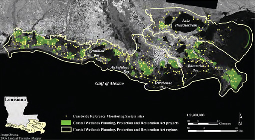
FIGURE 3.1 Map of CRMS sites throughout coastal Louisiana in relation to four regions defined by the Coastal Wetlands Planning, Protection and Restoration Act (CWPPRA) and CWPPRA projects coastwide.
SOURCE: Steyer et al., 2003; the National Library of Medicine.
a benchmark pipe driven into the ground to the point of refusal (Boumans and Day, 1993; Cahoon et al., 2000). Change in elevation is determined by comparing repeated measures of monthly samples relative to the means of the first measurements.
Water Quality—Nutrient Regulation4
Ecosystems receive nutrient inputs and process nutrients through nutrient uptake, regeneration, and transformation. Nutrient processing includes the natural functions of nutrient cycling in wetlands, submerged vegetation, and subsurface sediments along the gradient of tidally influenced ecosystems to across the continental shelf soft-bottom habitats and into similar ecosystems of the deep GoM. The nutrients most often considered are nitrogen and phosphorus because an excess of these nutrients can enhance
_____________
4 As water quality in the GoM coastal waters is significantly influenced by nutrient regulation, discussion of these two ecosystem services has been combined in this section.
primary production and lead to eutrophication and negative impacts such as reduced water clarity, noxious and harmful algal blooms, and oxygen depletion. In addition, silica is important because it is required by diatoms, the dominant primary producers at the base of aquatic food webs. Decreases in silica loads or an imbalance of the ratio of either nitrogen or phosphorus to silica can cause the phytoplankton community to shift composition to non-diatom phytoplankton including toxic dinoflagellates or cyanobacteria. The ecosystem service provided by nutrient cycling is the maintenance of major nutrients within acceptable concentrations, so that negative impacts, such as eutrophication and altered trophic structure, are minimized.
Much of the variation in water quality in the GoM coastal waters is driven by inputs from the Mississippi River, delivering 80 percent of the freshwater inflow, 91 percent of the annual nitrogen load, and 88 percent of the phosphorus load to the northern part of the Gulf (Turner et al., 2007). Measurement of nutrient concentrations is important since it yields valuable information regarding primary production in the region (Lohrenz et al., 1997). The measurement of nutrient concentrations is also valuable in terms of oil spills, since nutrients play an important role in the microbial biodegradation of hydrocarbons (Leahy and Colwell, 1990) and also in terms of organic loading from surface phytoplankton production. Both degradation processes lower the saturation of dissolved oxygen (DO), creating oxygen anomalies in deep waters where hydrocarbons are present (Kessler et al., 2011) or leading to large and perennial “dead zones” (areas of oxygen depletion on the Louisiana continental shelf) (Rabalais et al., 2002, 2007b).
According to Farber et al. (2006) the service of nutrient processing is somewhat amenable to economic valuation, which can be measured by its impact on water quality through avoided treatment costs. Wetlands are widely recognized for their capacity to remove nutrients from overlying waters, in effect improving water quality (Engle, 2011). The ability of wetlands and soft-bottom sediments to cycle nutrients could potentially be disrupted by the presence of hydrocarbons layering the sediments or potentially damaging the health and vitality of wetlands and is thus a major consideration in assessing ecosystem services as part of a damage assessment.
Increases in nutrient loads, primarily nitrogen and phosphorus, often lead to eutrophication, the increase in carbon production through photosynthesis and accumulation of that carbon in the aquatic system (Rabalais, 2004; modified from Nixon, 1995). Negative impacts of eutrophication are oxygen deficiency (hypoxia) and harmful algal blooms. When DO concentrations fall below a certain level to create a low oxygen condition known as hypoxia, and this condition persists, the biodiversity and availability of
suitable habitat for most sea life is compromised. Certain mobile species will migrate away from the affected area, but sessile or burrowing species may die (Engle et al., 1997; Rabalais and Turner, 2001). When a density barrier (pycnocline) due to salinity or temperature differences, or both, is present in the water column, diffusion of oxygen from surface waters is inhibited across this barrier so that consumption of oxygen by aerobic bacteria depletes the oxygen in the water below the barrier at a much greater rate than it can be supplied. The resultant hypoxia can become so severe that the behavior, physiology, and capacity of organisms to survive are threatened. The northern Gulf of Mexico has two areas of lower oxygen: (1) a 300- to 800-m-thick layer of natural low oxygen in water depths of 1,000 m or deeper in the open Gulf of Mexico (Conseil Permanent International pour l’Exploration de la Mer, 1936) and (2) the human-caused low oxygen area on the Louisiana continental shelf resulting from increasing and excess nutrient loads (Rabalais et al., 2002) (see Box 3.1).
Water quality data including nutrients are available at the USGS5 for major rivers. Individual states also maintain water quality data in support of U.S. Environmental Protection Agency (EPA) requirements of the Clean Water Act for drinking water and for determination of impaired uses. The availability of nutrient data for specific areas potentially affected by the oil spill is limited. Also, the data for uptake and regeneration of multiple forms of nutrients, nitrogen, and phosphorus within wetlands are sparse and data within oiled wetlands are essentially non-existent.
In terms of baseline DO data for the GoM, a nationwide review of DO conditions in estuaries was undertaken by the Ocean Assessments Division of NOAA to collate historical data from individual estuaries in the GoM and report on the status of Gulf-wide DO conditions (Rabalais et al., 1985; Windsor, 1985). These reports combined data from numerous programs to identify sites with definite DO problems or with marginal or deteriorating water quality. The most recent compilation of estuarine condition, including DO, in GoM estuaries and some offshore waters is in Bricker et al. (2007). Offshore and open Gulf of Mexico water quality data including nutrients are mostly stored at the NOAA National Oceanographic Data Center.6
_____________
BOX 3.1 HYPOXIA IN THE GoM
For almost 30 years, scientists have been monitoring DO concentrations in the bottom waters of the northern GoM to better understand the distribution and dynamics of hypoxia in the region (Rabalais et al., 2007b). Large areas of the GoM are seasonally hypoxic, reaching 22,000 km2, the size of the state of Maryland.a Hypoxia results from the stimulation of algal and bacterial production due to excess nitrogen and phosphorus delivered by the Mississippi-Atchafalaya River Basin (Turner et al., 2007; Greene et al., 2009) and is maintained by the seasonal stratification of Gulf waters (Rabalais et al., 2007a). The general consensus is that hypoxia in the northern GoM has worsened over the past century as nutrient loads increased (Rabalais et al., 2007b; EPA, 2009). The number and duration of hypoxic and severely hypoxic events vary from year to year according to nutrient loading, freshwater discharge, and weather patterns (Turner et al., 2006; Greene et al., 2009). The most important factors in determining the hypoxic potential of estuaries are the tendency for stratification, the rate of flushing, and the extent of organic loading.
The loss of ecosystem services in the form of fish kills, benthic defaunation, decreased diversity of fish and benthic invertebrates, and disruption of nutrient cycling are attributed to hypoxia or anoxia (absence of DO) (Rabalais and Turner, 2001). Large-scale economic consequences include reduced production of commercially and recreationally valuable fish and shellfish (Diaz and Rosenberg, 1995; Breitburg, 2002), changes in the relative importance of various trophic pathways within food webs (Caddy, 1993; Turner et al., 1998; Breitburg et al., 2009), and a reduction in the economic value of some fisheries (Lipton and Hicks, 2003; Mistiaen et al., 2003).
_____________
aSee http://www.gulfhypoxia.net.
PROVISIONING SERVICES
Food
Indirect and direct food provisioning are recognized ecosystem services. For example, consider a deep-shelf hard-bottom ecosystem within the GoM. The ecosystem’s ability to produce organisms that are consumed by humans (food) is dependent on a relatively stable ocean environment, and a complex food web that contains a large number of organisms not directly consumed by humans (the indirect provisioning component). In addition, this system, like most marine systems, may depend on the productivity of neighboring ecosystems, such as nutrient inputs from shallower waters, because ocean
basins have strong ecological connectivity. Any change to a part of this system may directly or indirectly change food provisioning. Harvest of food species may reduce their population to levels that make it less productive. Similarly, the harvest of food species may alter the balance in the food chain, changing the ability of the ecosystem to support food production.
Because food provisioning includes artisanal fishing but is mostly captured through commercial fisheries, and because state and federal governments regularly model and collect data on commercial fisheries, baseline data on the kinds and amount of direct food provisioning are available. The primary database for U.S. commercial fisheries is maintained by the National Marine Fisheries Service (NMFS).8
Important commercial species in the Gulf region include oysters, shrimp, menhaden, red snapper, tunas, groupers, crawfish, mullets, blue crab, and stone crab; from 2000 to 2009 these species or species groups represented an average of 96 percent of total landings. In 2009, finfish and shellfish landings in the GoM totaled 1.4 billion pounds and earned $629 million in revenues (NOAA, 2010a). Historical data on landings provide a way to estimate the historic economic value of commercial fisheries at the dock. Commercial fisheries data are expected to include both indirect and direct food provisioning values. Commonly used multipliers can provide estimates of the economic benefits generated by seafood products as they move through processing, wholesale, transport, and retail phases. The economic value of seafood to consumers, or consumer surplus, is more difficult to measure.
Understanding ecosystem dynamics that regulate food production, however, is much more challenging. Government agencies emphasize collection of data on the removal of managed species, including those that are a source of food, recreation, or that have a special conservation value (marine mammals, sea turtles, corals). The same agencies put much less effort into collection of data on species that may be affected by fishing but do not have a commercial value (by-catch). The result of such monitoring represents an uneven coverage of the different components of the ecosystem that may be supporting food production. Returning to the example of the hard bottom, generally there will be detailed information on the major species of harvested fish, but much less data on all other species, some of which may be supporting the harvested species.
In addition to data on landings, pre-spill stock assessment processes
_____________
7 See http://www.st.nmfs.noaa.gov/st1/commercial/index.html.
can supply information on projected post-spill landings. In the case of a rebuilding fishery, data on historic landings, projected over the recovery period, would underestimate the loss of “but-for-the-spill” potential landings. At the same time, those parties representing the public’s interests in a damage assessment case (i.e., trustees) should also consider the extent to which the spill might increase future landings by necessitating temporary fishery closures that might accelerate rebuilding of overfished stocks. Although stock assessment processes do commonly make predictions on future yield it is less common to have predictions on the economic value of “but-for-the-spill” yields. The reason is that predictions of seafood demand and prices are often a function of global markets and not exclusively of regional production.
Nineteen percent of the U.S. fish catch over the period from 2003-2008 was not destined for direct human consumption but rather for other products such as fish meal and fish oil (NOAA, 2010b). The Gulf menhaden fishery, which primarily operates in Louisiana, is the second largest U.S. fishery by weight, producing approximately 500,000 tons a year of landed catch (Vaughan et al., 2007). This fishery produces 60 percent of the total U.S. catch not destined for human consumption (NOAA, 2010a,b). In addition to fish meal and fish oil, a significant portion of menhaden catch is used as bait in other fisheries such as those for crustaceans and various finfish (VanderKooy and Smith, 2002). Fish oil is mainly used in products for human consumption but a small portion is used for livestock and aquaculture feeds (VanderKooy and Smith, 2002).
Assessment of this stock is based on fishery-independent data on juvenile abundance, fishery-dependent data on adult abundance, landing statistics and life history parameters. A catch-at-age model applied to these data by Vaughan et al. (2007) obtained relatively precise estimates indicating that as of 2004 the stock and fishery were operating sustainably within the limits set by managers. This estimation of stock status allows the NMFS to release annual forecasts of catch for the GoM menhaden fishery that have historically been accurate within 14 percent (NOAA, 2011b).
VanderKooy and Smith (2002) cite oil spills and petroleum extraction as potentially having negative effects on fish survival and recruitment of Gulf menhaden. Other factors, related to the interactions of natural events and human activity (hurricanes, climate cycles, pollution, coastal development, wetland degradation wetland loss, river runoff, algal blooms, hypoxic zones), can also affect fishery operations and the abundance and survival of Gulf menhaden (VanderKooy and Smith, 2002; Vaughan et al., 2007) or other species (Chesney and Baltz, 2001).
Raw Material Services from Oil and Gas
The Gulf of Mexico is a major source of oil and gas as a provisioning ecosystem service. According to the Bureau of Ocean Energy, Management, Regulation and Enforcement (BOEMRE), the GoM Outer Continental Shelf produced 510 million barrels of oil and 2.8 trillion cubic feet of gas in 2009, which amounts to about 29 percent of all the oil produced in the United States and 13 percent of gas. The history of oil production from the Gulf from 1970 to 2008 indicates that while production in shallow water has been rapidly declining, production in deep water has risen dramatically and accounted for 76 percent of offshore production in the Gulf by 2008 (Figure 3.2).9
This oil and gas production provides valuable resources as essential raw ingredients for fuels, lubricants, plastics, medicines, fertilizers, etc. The 4,000 active and inactive production rigs also provide a substrate as artificial reefs upon which organisms settle and create diverse marine communities to which fish are attracted, but note that these rigs can also have negative environmental impacts. This example of the rigs generating both positive and negative environmental effects highlights a societal tension between ecosystem services and the benefits that they provide in the GoM and elsewhere. Improvements to one service may actually come at the expense of another. For example, enhancing the regulating services such as hazard moderation (by protecting intact wetlands and mangroves that provide storm surge protection) may come at the expense of other services such as provisioning services provided by the raw materials such as gas and oil.
Calculating a baseline of raw material resources provided by oil and gas would require quantifying each of these items. Estimating some of them is fairly straightforward using existing databases, e.g., using known prices and production volumes from the BOEMRE database as cited above. Other items, such as provisioning of hard substrates for diverse biological communities, are more difficult to quantify.
Loss of oil and gas resources as a result of the DWH spill are ultimately attributable to delays in bringing on new production through drilling moratoria and longer permitting times. Deepwater drilling activity since the DWH spill dropped by about 65 percent; in shallow water the drop has been less severe but is still 35 percent as of March 2011 (Figure 3.3).
_____________
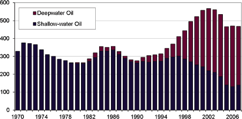
FIGURE 3.2 History of annual oil production in the GoM (from BOEMRE).
SOURCES: U.S. Department of the Interior, 2011; RigData, 2009; with permission from David E. Dismukes, Louisiana State University, Center for Energy Studies.
CULTURAL SERVICES
Spiritual and Historic
Spiritual and historic connections to land and water are what define many communities and people around the world, and this is true for the Gulf coast. From the Biloxi-Chitimacha, Houma, and Atakapa-Ishak tribes, to the Cajun (French Acadians), and to the Hmong and Vietnamese fishing communities, to name just a few, there is an important attachment to the land and water. Through generations, indigenous peoples have grown to depend on their environment for essential resources, and therefore have a stake in restoring, maintaining, and enhancing its biological diversity (Gadgil et al., 1993). The very nature of this ecosystem service makes it difficult to measure its importance in any form, much less monetary value. Yet, spiritual and historic connections are passions of individuals and communities that motivate them to action.
As an example of the spiritual and historic importance of our natural environment, the Millennium Ecosystem Assessment addressed the function of forests: “Forests play important cultural, spiritual, and recreational roles in many societies. For many indigenous and otherwise traditional societies,
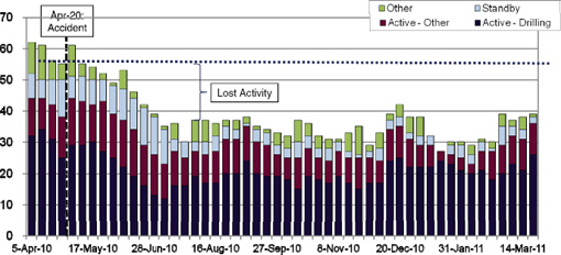
FIGURE 3.3 Time history of the number of drill rigs operating in the Gulf from April 2010 to March 2011.
SOURCES: U.S. Department of the Interior, 2011; Rig Data, 2009; with permission from David E. Dismukes, Louisiana State University, Center for Energy Studies.
forests play an important role in cultural and spiritual traditions and, in some cases, are integral to the very definition and survival of distinct cultures and peoples. Forests also continue to play an important role in providing recreation and spiritual solace in more modernized, secular societies, and forests and trees are symbolically and spiritually important in most of the world’s major religious traditions” (Millennium Ecosystem Assessment, 2005). This same statement is appropriate for the bayous, bottomland hardwoods, salt and freshwater wetlands, and barrier islands of the Gulf.
It is difficult to quantify the value of the spiritual and historic attachment to land and water. Catastrophic events, whether acute (oil spills or hurricanes) or gradual (decrease in sediment load or sea-level rise), impact both communities and individuals. As a result of the Exxon Valdez oil spill, the community culture, which was characterized by a fishing lifestyle and connections to the natural environment before the spill, then shifted to a community that was involved only in cleanup operations. The spill also disrupted the traditional practice of sharing and exchanging subsistence harvests, an important identity of Alaskan indigenous people (Picou et al., 2009). Community beliefs are that when sacred sites are destroyed alternatives do not exist, and totem species that become impaired or extinct cannot be replaced (Cooper, 2009). Communities along the Gulf coast and especially the Mississippi River delta region have been dealing with adversity for decades mainly due to habitat loss and multiple hurricanes. Early evidence suggests that many of the issues associated with the Exxon Valdez oil spill are occurring with the DWH oil spill (Ritchie et al., 2011). An important part of the Cajun and Native American identity is commercial fishing and the link to coastal waters. The threat to livelihoods is also a threat to their identity of self-reliance and independence (Guarino, 2010). Similar threats to the livelihoods of immigrant cultures (from Filipino fishers with shrimp drying platforms and Croatian oystermen in the 1800s to more recent Vietnamese and Hmong shrimp trawlers) are equally important.
Endemic and translocated cultures are facing challenges associated with changing environmental conditions and social pressures. The important traditional subsistence hunting and fishing that is part of their everyday lives is being recognized formally by the Gulf Coast Claims Facility. As one individual put it, the subsistence claims are “a claim that my lifestyle has been adversely impacted by my inability to any longer live off the resources that I hunt or catch … what I could go hunt or fish I now have to go buy” (Budreau, 2011). These sorts of impacts on spiritual or cultural values also raise concerns related to environmental justice.10
_____________
Perhaps the most important contribution of trying to evaluate spiritual ecosystem services might be that it acts as a reminder that there are values that cannot be reduced to figures (Cooper, 2009).
Aesthetics and Existence
Gulf ecosystems provide value to people in the form of aesthetic experiences and existence amenities. Aesthetic experiences are provided to the general public insofar as they visit beaches, watch wildlife, and enjoy navigating through inland and offshore areas. Existence amenities include knowledge or awareness about specific components of the GoM system, such as knowing that migrating birds use habitats in the northern Gulf of Mexico, as well as more abstract ideas such as feeling a sense of inspiration from or harmony with nature as represented by the GoM, or associating the GoM with a strong emotional attachment. While these amenities range from fairly concrete to substantively more abstract, they are nevertheless real in economic terms. It is well documented that people value knowing that oceans and wetlands are healthy (Baird, 1995; Turner et al., 2000), that fish and wildlife populations exist, and that systems and their component parts will be available for their children and grandchildren to enjoy.
Data on aesthetic values can be directly obtained from reports on tourism spending and the relative value of coastal property and, indirectly, from economic studies using methods such as travel cost and the hedonic valuation of real property. Because there is no market capturing existence values, estimates can only be obtained through indirect methods such as surveys of willingness-to-pay or willingness-to-accept and other forms of contingent valuation (see Chapter 4).
Recreational Opportunities and Tourism
Recreation and tourism are one of the most direct aesthetic links that people have with the environment and these services can generate large benefits, especially in the context of coastal and marine ecosystems. Tourism, as it is often defined, involves travel of at least a given distance (e.g., 50 miles or more) to engage in recreation. We use the term recreational services to cover both recreation and tourism. Recreational services along the Gulf coast include fishing, hunting, bird watching, camping, hiking, beach going, boating, diving, snorkeling, and swimming. The economic impact of recreational services can be significant. In 2008, the coastal congressional districts of the Gulf States experienced a level of travel spending of
TABLE 3.2 GoM Saltwater Anglers and Days, 2006 (population 16 years and older; number in thousands).
|
|
||||||
|
State Where Fishing Took Place |
Anglers |
|||||
|
|
||||||
|
Total Anglers, Residents and Nonresidents |
State Residents |
Nonresidents |
||||
|
|
|
|
||||
|
Number |
Percent |
Number |
Percent |
Number |
Percent |
|
|
|
||||||
|
Alabama |
153 |
100 |
89 |
59 |
63a |
41a |
|
Florida |
2,002 |
100 |
1,286 |
64 |
716 |
36 |
|
Louisiana |
289 |
100 |
248 |
86 |
42a |
14a |
|
Mississippi |
66a |
100a |
57a |
87a |
… |
… |
|
Texas |
1,147 |
100 |
1,070 |
93 |
77 |
7 |
|
|
||||||
aEstimates based on a sample size of 10-29 thousand.
SOURCE: National Survey of Fishing, Hunting, and Wildlife-Associated Recreation.
$53 billion and travel employment of 605,000 (U.S. Travel Association, 2009).
An important source of wildlife-based recreation statistics is the National Survey of Fishing, Hunting, and Wildlife-Associated Recreation that is conducted every five years by the U.S. Fish and Wildlife Service, in association with the Census Bureau. The most recent of these surveys, conducted in 2006 (U.S. Department of Interior, 2007), reports statistics on the number of participants, days participated, trips taken, species targeted, expenditures, and demographic characteristics of participants. Survey questions and methodology were similar to surveys conducted in 2001, 1996, and 1991 so that estimates across surveys are comparable, allowing trends to be calculated. Separate statistics are collected for freshwater versus saltwater fishing; no distinction is made between coastal and inland hunting and wildlife watching. Table 3.2 presents data from the report for GoM states. Florida and Texas dominate the number of recreational anglers and angler days in the Gulf and for the country as well.
An important source of saltwater recreational fishing data is the NOAA Fisheries Marine Recreational Information Program (formerly the Marine Recreational Fisheries Statistics Survey).11 The purpose of this program is to gather information on participation, fishing effort, catch, and socio-economic characteristics of the participants. Data can be retrieved using a number of filters including dates, waves (two month time periods), geographical area that includes states or regions, the type of fishing (shore, charter, party boat,
_____________
11 See http://www.st.nmfs.noaa.gov/st1/recreational/index.html.
|
|
||||||
|
Days of Fishing |
||||||
|
|
||||||
|
Total Days, Residents and Nonresidents |
Days by State Residents |
Days by Nonresidents |
||||
|
|
|
|
||||
|
Number |
Percent |
Number |
Percent |
Number |
Percent |
|
|
|
||||||
|
758 |
100 |
530 |
70 |
229a |
30a |
|
|
23,077 |
100 |
19,553 |
85 |
3,524 |
15 |
|
|
2,975 |
100 |
2,541 |
85 |
433a |
15a |
|
|
590a |
100a |
573a |
*97a |
… |
… |
|
|
15,143 |
100 |
14,380 |
95 |
762 |
5 |
|
|
|
||||||
etc.), fishing area (state waters, federal waters, inshore, etc.), type of catch (caught and released, used for bait, kept), and by weight or numbers. The statistics do not include any data from Texas, because they have elected not to participate.
Systematic data are generally not available for other forms of outdoor recreation not covered by the National Survey of Fishing, Hunting, and Wildlife-Associated Recreation and the Marine Recreational Information Program. There are, however, some other studies that are conducted for specified regions and/or activities (see Fesenmaier et al., 1989; Gillig et al., 2000, Scott and Associates, 2004; NOEP, 2006).
A recent report prepared for the Louisiana Office of Tourism attempts to quantify the impact of the oil spill on tourism in that state (Tourism Economics, 2010). They report that visits to state parks were down 5 percent in the second quarter of 2010 versus the second quarter of 2009. Second, and more telling of the impact of the spill, is that fishing license revenue was down by 45 percent versus the same period the year before. Much of this downturn can be correlated to fishing closures that were instituted as a result of the oil spill.
SUMMARY
This chapter provides a preliminary discussion for identifying and describing the appropriate methods and types of information available to approximate baselines, and for distinguishing effects on ecosystem services specific to the spill. As a starting point, the committee utilized a list of
ecosystem services in the GoM that were identified by regional experts (Yoskowitz et al., 2010). Here we presented some of those ecosystem services with reasonable and calculable values and supporting databases.
This chapter is not intended to be comprehensive, but rather to highlight key parameters and provide guidance for determining changes in various ecosystem services. In approaching this task, three fundamental questions were addressed for each service specified: (1) describe the current state of knowledge, (2) identify the important measurable parameters, and (3) identify the best methods available to conduct those measurements. As reflected in this chapter, research and data for some services are much more readily available than others. Additionally, we must acknowledge there are many aspects of Gulf ecosystems that are dynamically changing from both natural and human-caused processes. This reality will make identifying appropriate baseline information a particular challenge.


