


Below is the uncorrected machine-read text of this chapter, intended to provide our own search engines and external engines with highly rich, chapter-representative searchable text of each book. Because it is UNCORRECTED material, please consider the following text as a useful but insufficient proxy for the authoritative book pages.
49 CHAPTER SIX EARTHWORK TECHNIQUES EPA, Guidance Specifying Management Measures for Sources of Nonpoint Pollution in Coastal Waters, EPA 840- B-92-002, Office of Water, EPA, Washington, D.C., 1993. EPA, Development Document for Final Action for Effluent Guidelines and Standards for the Construction and Development Category, EPA-821-B-04-001, EPA, Washington, D.C., 2004. EPA, National Pollutant Discharge Elimination System: National Menu of Stormwater Best Management Practices, Stormwater Best Management Practices, EPA, Washing- ton, D.C., 2008 [Online]. Available: http://cfpub1.epa.gov/ npdes/stormwater/menuofbmps/index.cfm. EPA, Stormwater Management for Industrial Activities: Developing Pollution Prevention Plans and Best Management Practices, Office of Water, EPA, Washington, D.C., 1992. Keller, G. and J. Sherar, Low-Volume Roads Engineeringâ Best Management Practices Field Guide, USDA Forest Ser- vice, Office of International Programs, and U.S. Agency for International Development, Washington, D.C., 2003 [Online]. Available: http://www.fs.fed.us/global/topic/welcome.htm#12. Long, M.T., âHorizontal Drains, Application and Design,â Section 6D, In The Slope Stability Reference Guide for National Forests in the United States, Engineering Staff, Forest Service, USDA, Washington D.C., Dec. 1993 [Online]. Available: http://www.fs.fed.us/rm/pubs_other/ wo_em7170_13/wo_em7170_13_vol3.pdf. State of Delaware, Delaware Erosion and Sediment Con- trol Handbook for Development, Division of Water Conser- vation, Department of Natural Resources and Environmental Control, Dover, 1989. State of North Carolina, Erosion and Sediment Control Planning and Design Manual, North Carolina Sedimentation Control Commission and North Carolina Department of Nat- ural Resources and Community Development, Raleigh, 1988. BENCHED SLOPES Many types of slope modifications include terraces, benches, steps, and serrations that are used to minimize erosion and con- This section summarizes literature and interview results on earthwork techniques. Earthwork techniques involve the physical movement of soil, rock, and/or vegetation for the purpose of erosion control and slope stabilization. As part of construction site planning and management, earthwork techniques can be employed to reshape the ground surface to planned grades and to âcontrol surface runoff, soil ero- sion, and sedimentation during and after constructionâ (EPA 2008). For instance, land grading can be used to treat sites with uneven or steep topography or easily erodible soils so as to stabilize slopes, whereas gradient terraces can be used to reduce sediment-laden runoff by âslowing, collecting and redistributing surface runoff to stable outletsâ (EPA 2008). IMPLEMENTING EARTHWORK TECHNIQUES Similar to other slope stabilization techniques, the implemen- tation of earthwork techniques can benefit greatly from good planning that tailors the solution(s) to specific site challenges and constraints. The planning could consider whether a spe- cific tool is suitable for the site (e.g., âgradient terraces are inap- propriate for use on sandy or shallow soils, or on steep slopesâ), the proper selection of site areas to be graded, the proper spac- ing and grading of slopes or terraces, the drainage patterns, acceptable outlets of redirected runoff, the timing of earthwork, the handling of excess or borrowed materials, and maintenance considerations (e.g., inspection after heavy rainfalls) (EPA 2008). For instance, in the early stages of design to minimize the risk of plane failure conduct engineering geological map- ping when man-made cut slopes are to be constructed (Yue and Lee 2002). Existing drainage patterns are to be maintained wherever possible and measures are to be taken to minimize disturbed areas and exposed soils and to minimize possible ero- sion, sedimentation, and dust from exposed soils (EPA 20008). Useful Points ⢠Avoid burying stumps, logs, slash, or organic debris in the fill material or in the road prism (Keller and Sherar 2003). Additional Resources for Earthwork Techniques Boaze, P. and B. Wiggins, âBuilding a Major Highway in Mountainous East Tennessee: Environmental Impacts,â Land and Water, Vol. 44, No. 4, 2000, pp. 20â23.
50 trol runoff (TIRRS 2001) (Figures 42 and 43). Slope shaping can also provide sites for vegetation to establish. Benches, terraces, steps, or serrations are mainly distinguished by size (TIRRS 2001). Slope shaping is well suited for large cut-and-fill slopes. The size of the bench to be installed is determined by the length and degree of the slope (Table 5). For example, long or steep slopes may require many short benches, while less steep slopes may be stabilized with steps or serrations (TIRRS 2001). When creating these feature on a slope, it is important not to leave the surface too smooth but to allow for microtopographyâsmall uneven bumps and ridges that will collect moisture and seeds and improve chances for successful vegetation (Goldman et al. 1986, TIRRS 2001). Serrated slopes generally do not work well in erodible soils and result in further erosion of serrations. Large benches or terraces are generally more effective in erodible soils (G. Keller, personal communication, Nov. 22, 2011). Two main advantages of benched cut slopes, from a sta- bility point of view, is their ability to slow down the rate of surface runoff, and the fact that shallow failures are usually limited to one bench at a time (Hearn and Weeks 1997). The steps on a benched cut slope should slope into the hillside and have a drainage system installed. Vegetation is more dif- ficult to establish on the steeper riser slopes than on a uni- form slope profile. Benches provide an area for vegetation to grow, catch falling material, break up the areas of drainage, and the like (Hearn and Weekes 1997). Maintenance of benches includes periodic inspection for damage from runoff (TIRRS 2001). If not repaired, rills and gullies may develop. Accumulated sediment may also need to be removed to prevent blockage of drains. Maintenance activities have potential for increasing erosion; therefore, limit site disturbances as much as possible. Building terraces does not work well on decomposed granitic soils or in areas with high groundwater tables (TIRRS 2001). FIGURE 43 Constructed terraces on exposed slopes, Asmara-Assab Road, Eritrea (Courtesy: A. Faiz). TABLE 5 EXAMPLES OF SLOPE MODIFICATION TECHNIQUES AND THE GENERAL PARAMETERS USED TO CREATE THEM Slope Modification Techniques Design Parameters Benches or Terraces 4 to 10 ft (1.2 to 3 m) wide horizontally, level or slightly sloping toward the slope (reverse sloping) Steps 1 to 4 ft (0.3 to 1.2 m) wide, usually horizontal Serrations ~ 10 in. (25 cm) wide, cut by a serrated wing blade Source: TIRRS (2001). Additional Resources for Benched Slopes Abramson, L.W., T.S. Lee, S. Sharma, and G.M. Boyce, Slope Stability and Stabilization Methods, John Wiley & Sons, New York, N.Y., 2002. FIGURE 42 Constructed terraces on an exposed slope, taken after construction (left); Taken 6 months later after a heavy monsoon season (right), Jhelum Valley Road, Pakistan. (Courtesy: A. Faiz).
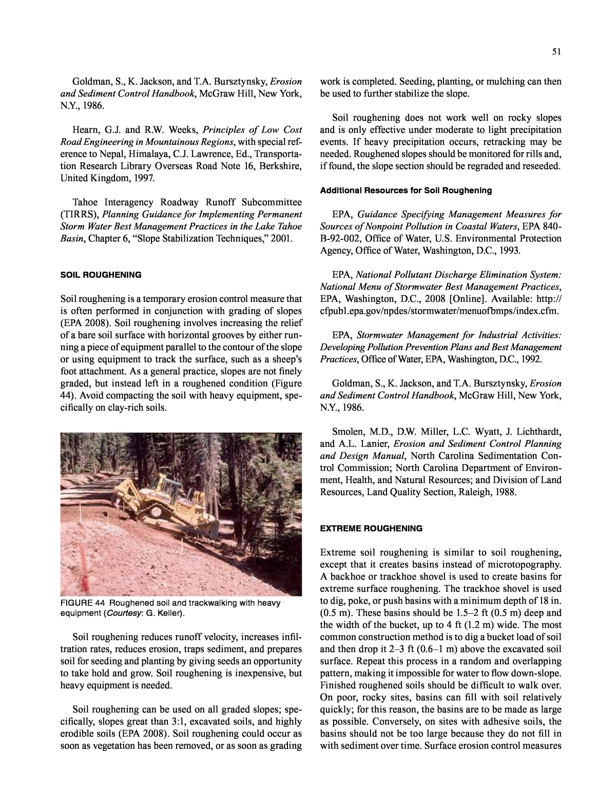
51 Goldman, S., K. Jackson, and T.A. Bursztynsky, Erosion and Sediment Control Handbook, McGraw Hill, New York, N.Y., 1986. Hearn, G.J. and R.W. Weeks, Principles of Low Cost Road Engineering in Mountainous Regions, with special ref- erence to Nepal, Himalaya, C.J. Lawrence, Ed., Transporta- tion Research Library Overseas Road Note 16, Berkshire, United Kingdom, 1997. Tahoe Interagency Roadway Runoff Subcommittee (TIRRS), Planning Guidance for Implementing Permanent Storm Water Best Management Practices in the Lake Tahoe Basin, Chapter 6, âSlope Stabilization Techniques,â 2001. SOIL ROUGHENING Soil roughening is a temporary erosion control measure that is often performed in conjunction with grading of slopes (EPA 2008). Soil roughening involves increasing the relief of a bare soil surface with horizontal grooves by either run- ning a piece of equipment parallel to the contour of the slope or using equipment to track the surface, such as a sheepâs foot attachment. As a general practice, slopes are not finely graded, but instead left in a roughened condition (Figure 44). Avoid compacting the soil with heavy equipment, spe- cifically on clay-rich soils. FIGURE 44 Roughened soil and trackwalking with heavy equipment (Courtesy: G. Keller). Soil roughening reduces runoff velocity, increases infil- tration rates, reduces erosion, traps sediment, and prepares soil for seeding and planting by giving seeds an opportunity to take hold and grow. Soil roughening is inexpensive, but heavy equipment is needed. Soil roughening can be used on all graded slopes; spe- cifically, slopes great than 3:1, excavated soils, and highly erodible soils (EPA 2008). Soil roughening could occur as soon as vegetation has been removed, or as soon as grading work is completed. Seeding, planting, or mulching can then be used to further stabilize the slope. Soil roughening does not work well on rocky slopes and is only effective under moderate to light precipitation events. If heavy precipitation occurs, retracking may be needed. Roughened slopes should be monitored for rills and, if found, the slope section should be regraded and reseeded. Additional Resources for Soil Roughening EPA, Guidance Specifying Management Measures for Sources of Nonpoint Pollution in Coastal Waters, EPA 840- B-92-002, Office of Water, U.S. Environmental Protection Agency, Office of Water, Washington, D.C., 1993. EPA, National Pollutant Discharge Elimination System: National Menu of Stormwater Best Management Practices, EPA, Washington, D.C., 2008 [Online]. Available: http:// cfpub1.epa.gov/npdes/stormwater/menuofbmps/index.cfm. EPA, Stormwater Management for Industrial Activities: Developing Pollution Prevention Plans and Best Management Practices, Office of Water, EPA, Washington, D.C., 1992. Goldman, S., K. Jackson, and T.A. Bursztynsky, Erosion and Sediment Control Handbook, McGraw Hill, New York, N.Y., 1986. Smolen, M.D., D.W. Miller, L.C. Wyatt, J. Lichthardt, and A.L. Lanier, Erosion and Sediment Control Planning and Design Manual, North Carolina Sedimentation Con- trol Commission; North Carolina Department of Environ- ment, Health, and Natural Resources; and Division of Land Resources, Land Quality Section, Raleigh, 1988. EXTREME ROUGHENING Extreme soil roughening is similar to soil roughening, except that it creates basins instead of microtopography. A backhoe or trackhoe shovel is used to create basins for extreme surface roughening. The trackhoe shovel is used to dig, poke, or push basins with a minimum depth of 18 in. (0.5 m). These basins should be 1.5â2 ft (0.5 m) deep and the width of the bucket, up to 4 ft (1.2 m) wide. The most common construction method is to dig a bucket load of soil and then drop it 2â3 ft (0.6â1 m) above the excavated soil surface. Repeat this process in a random and overlapping pattern, making it impossible for water to flow down-slope. Finished roughened soils should be difficult to walk over. On poor, rocky sites, basins can fill with soil relatively quickly; for this reason, the basins are to be made as large as possible. Conversely, on sites with adhesive soils, the basins should not be too large because they do not fill in with sediment over time. Surface erosion control measures
52 should be used. For example, straw can be spread during roughening and anchored to the soil surface by jabbing the materials into the soil surface or tacking them with hydro- mulch slurry. Consider broadcast seeding on extreme roughened slopes. In areas with extremely dry and loose soil, it may be advan- tageous to wait until the soil has settled before starting the seeding process. One method is to broadcast half the seed immediately and half after the soil settles. Problems may occur ifâ ⢠Basins are made when the soil is wet, causing hard, compacted soils to form in the depressions when dry. ⢠There is too much space between basins. Basins need to be overlapping. ⢠Basins are not large enough, making them suscep- tible to filling in with sediment prior to vegetation establishment. Soil roughening is a temporary erosion control measure. Additional Resources Wright, A., Ed., The Practical Guide to Reclamation in Utah, Utah Division of Oil, Gas and Mining, Salt Lake City [Online]. Available: https://fs.ogm.utah.gov/PUB/MINES/ Coal_Related/RecMan/Reclamation_Manual.pdf. Ripping of Soil Surface Ripping breaks up compacted layers of soil. Ripping is used as a soil-roughening technique in areas too large to economi- cally roughen with a backhoe. Seed can be simultaneously spread with the ripping operation if a broadcast seeder is attached to the ripping equipment. Soil amendments or sur- face mulch are to be incorporated into the soil during the ripping operation or anchored with non-surface-disturbing methods such as tackifier or netting. Rip soils when they are dry to permit shattering beneath the surface. Ripping guidelines are as follows: ⢠Rip to a depth of 2â3 ft (0.6â1 m) and at similar intervals. ⢠Rip on contour to the slope. ⢠Rip 10â20 ft (3â6 m) and then start again; this will reduce long water pathways. Additional Resources for Ripping of Soil Surface Wright, A., Ed., The Practical Guide to Reclamation in Utah, Utah Division of Oil, Gas and Mining, Salt Lake City [Online]. Available: https://fs.ogm.utah.gov/PUB/MINES/ Coal_Related/RecMan/Reclamation_Manual.pdf. FLATTENING SLOPES Flattening oversteep slopes or slope reprofiling is a technique used to trim slopes back to a gentler slope angle (Hearn and Weekes 1997). To reprofile the slope, material is unloaded from the head or top of the slope, and/or material is placed at the base of the slope (also called toe weighting). Slope reprofiling generally increases slope stability, but is not fea- sible to do over large areas. Other disadvantages of flattening slopes are that acquiring additional right-of-way may be nec- essary, there may be a need to dispose of excess soil (often more is removed than replaced), and it can be difficult to â[find] a practical place to start the excavationâ (Abramson et al. 1996). Nevertheless, slope reprofiling is one of the most widely applied and economical methods for improving slope stability (Lee et al. 2002). Additional Resources for Flattening Slopes Abramson, L.W., T.S. Lee, S. Sharma, and G.M. Boyce, Slope Stability and Stabilization Methods, John Wiley & Sons, New York, N.Y., 2002. Hearn, G.J. and R.W. Weeks, Principles of Low Cost Road Engineering in Mountainous Regions, with special ref- erence to Nepal, Himalaya, C.J. Lawrence, Ed., Transporta- tion Research Library Overseas Road Note 16, Berkshire, United Kingdom, 1997. LANDFORMING, GEOMORPHIC MODIFICATION Landforming, or landform grading, aims to preserve the underlying landform through replication of geomorphology and associated vegetation, and to recreate or mimic stable nat- ural slopes using a wide variety of slope elements and forms (Schor and Gray 2007) (Figure 45). This method differs greatly from the traditional methods of slope grading used in hous- ing developments where linear flat pads and slopes are created. Although landform grading by itself will not prevent all erosion from occurring, the technique creates slope shapes that are less likely to suffer erosion and are more stable overall. âLandform grading provides a cost-effective, attractive, and environmentally compatible way to construct slopes and landforms that are superior in the long run in terms of resistance to surficial erosion and mass wastingâ (Schor and Gray 2007). The traditional, âengineeredâ approach to slope design is characterized by linear, horizontal alignments; planar surfaces of a uniform slope ratio with a sheet flow runoff pattern and uniform plantings; and often an abrupt transi- tion between man-made and natural slopes. The shape of tra- ditionally engineered slopes and other man-made creations
53 does not typically exist in the natural topography. Landform slope design is based on the various typical natural slope ele- ments identified and is characterized by concave and convex shapes, variable slope ratios, and diverse runoff patterns that encourage diverse revegetation patterns, as well as a more gentle transition between man-made and natural slopes (B. Schor, personal communication, June 5, 2011). Although it is believed that landforming techniques will translate to roadway environments, landforming may not be feasible in all highway situations because of restrictions or cre- ative limitations presented in typical linear right-of-ways adja- cent to roads (B. Schor, personal communication, June 5, 2011). Landform grading was originally developed as an alter- native to traditional grading; it has been used in many other applications since its inception, such as watershed restora- tion and mine reclamation. In a project conducted in 2004, landform grading was used in conjunction with traditional low-cost and environmentally friendly slope stabilization techniques at Nichols Arboretum in School Girlâs Glen in Ann Arbor, Michigan (Gray et al. 2004). Landform grad- ing was used to create stepped pools to handle unmitigated on-site water flow. Traditional slope stabilization techniques used were stone weirs, live staking and native plants, gabion check dams and root-wad revetment, and boulder cascades. Additional Resources for Landforming, Geomorphic Modification Schor, B. and D.H. Gray, Landforming: An Environmen- tal Approach to Hillside Development, Mine Reclamation and Watershed Restoration, John Wiley & Sons, Hoboken, N.J., 2007. FIGURE 45 Traditional grading versus landform grading (Courtesy: D. Gray).
