
Seagrass Restoration Monitoring
WHY RESTORE SEAGRASS?
Shallow coastal waters contain numerous and exceptionally rich and productive habitats. Of special concern here, but less well-known and appreciated by the public, are the extraordinarily productive, biologically diverse, and economically valuable seagrass meadows that are abundant in coastal areas of all continents except Antarctica. Seagrass meadows provide valuable ecosystem services such as important habitats and food for a range of iconic species such as manatees, green turtles, and seahorses; providing nursery grounds for numerous economically important finfish and shellfish; sequestering carbon; improving water quality by intercepting the nutrients and organic matter carried by land runoff; stabilizing sediments and preventing erosion (Barbier et al., 2011). Despite these important services, seagrass meadows are among the planet’s most threatened habitats, with their known global areal extent having declined by 29% since the late 1800s and losses rapidly accelerating in the last two decades (Waycott et al., 2009). On a global scale, this trend has significant ramifications because seagrass meadows have been estimated to provide ecosystem services for nutrient cycling alone valued at U.S. $7,700 per acre annually (Constanza et al., 1997). Others value seagrass’ contribution to enhanced fishery production in southern Australia at U.S. $172,000 ha-1 yr-1 (Blandon and zu Ermgassen, 2014). Thus, the potential economic impact of seagrass loss is significant (Hyndes et al., in review).
Because of their occurrence in shallow coastal waters, these meadows are highly susceptible to human-induced perturbations, especially those that reduce the quantity and quality of light (Orth et al., 2006). Temperature changes also affect seagrasses profoundly (Fraser et al., 2014). Recent worldwide increases in sea surface temperature, along with the predicted rises during the coming decades (IPCC, 2013), raise concern for the long-term survival of seagrasses in many areas. Thus, seagrass meadows, most of which are already stressed and in decline (Waycott et al., 2009), are at further risk of declining in the areal extent and ecological function and as a result there will be a further decline in the ecosystem services they provide. There is thus a clear and compelling need to assess the roadblocks to seagrass recovery and restore conditions that are favorable for the regrowth and long-term persistence of seagrass meadows.
RESTORATION OBJECTIVES
Post-DWH restoration and recovery efforts in the Gulf of Mexico are providing opportunities to expand and enhance seagrass meadows in many locations. The general objective of these efforts is to facilitate the development of seagrass meadows whose areal extent, abundance, species composition, function, and provision of ecosystem services are assessed to be equivalent to those of reference meadows (see Chapter 3). Although most restoration activities aim to restore seagrass meadows simply to enhance this ecosystem type, efforts are often motivated by the intrinsic benefits that seagrass provide to hundreds of other species, and by their benefits to humans, such as nursery habitat for commercially and recreationally valuable species like shrimp, crab, and fish (Beck et al., 2001). Despite this objective of restoring seagrass to increase animal utilization, activities are rarely monitored to assess restored density of target species.
It has long been known that these restoration objectives are most effectively achieved through improving environmental conditions, such as water clarity or nutrient availability, that enable seagrass to replenish and expand through natural processes or, less frequently, through transplantation (Fonseca et al., 1987, 1998). In general, replanting efforts have not often achieved their desired objectives in the Gulf of Mexico (Fonseca et al., 1987), although in one instance long-term monitoring of shoalgrass (Halodule wrightii) transplants showed slow increases in density over 7 years in the improving nutrient and light regimes of Tampa Bay (Bell et al., 2014).
DECISION-CRITICAL UNCERTAINTIES
Figure II.3 shows a conceptual model of some of the major factors that influence the areal extent, abundance, species composition, and functioning of seagrass meadows in the Gulf of Mexico, and in general, seagrass meadows wherever they occur. Ultimately, light is most often the resource limiting seagrass growth and
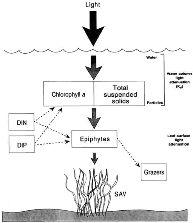
survival, and it is given priority in these conceptual models. However, other environmental variables such as temperature, salinity, sediment type and biogeochemistry, as well as wave energy, can singly or interactively hamper seagrass survival in the Gulf of Mexico. These variables are less likely to determine the success of seagrass restoration activities, which will most often take place in areas that previously supported seagrass growth, and when conditions initially responsible for the demise of seagrasses have been restored to levels approaching their previous state.
In cases where action is taken to restore seagrass, the effectiveness of that action can be assessed using the methods below. Monitoring for adaptive management links the effect of the action on a particular stressor to the effects of the restoration actions and recovery patterns as strongly as possible. If the meadow does not recover, there must be a reason why. Therefore, good practice is to monitor parameters that are most likely to affect recovery rate (e.g., water clarity, salinity, sediment quality; see below) as appropriate. If monitoring for adaptive management (see Chapter 3), this sampling will allow adjustment of restoration actions to increase the probability that seagrass will recover.
PROJECT-LEVEL MONITORING AND ASSESSMENT PLAN CONSIDERATIONS
Select Monitoring Types, Objectives, and Metrics
As defined in Part I of this report, the three primary purposes of restoration monitoring include (1) assuring projects are built and are initially functioning as designed (construction monitoring); (2) assessing whether restoration goals and objectives have been or are being met (performance monitoring); and (3) informing restoration management, improving design of future restoration efforts, and increasing ecosystem understanding (monitoring for adaptive management). A hierarchical strategy for seagrass
monitoring can be used to assess or evaluate the construction and performance of restoration efforts. Where warranted, the factors that establish quantitative relationships between physical and biotic parameters that ultimately control seagrass abundance, function, and persistence can be evaluated through monitoring for adaptive management. Also, monitoring certain parameters may enable scaling assessment ability up to a program, regional, and/or Gulf-wide level (see Table II.3). Given that planting of seagrasses will not usually achieve restoration objectives in the Gulf of Mexico, the following discussion focuses on restoration efforts that aim to improve environmental conditions for seagrass growth.
Monitoring protocols are primarily based on conceptual models (e.g., Figure II.3) that link: (1) light and nutrient availability to metrics of seagrass structure and function such as (a) shoot density and growth rates, and (b) landscape features, including patchiness and depth limit distributions; and (2) physicochemical stressors, including salinity, temperature, hydrodynamic processes, and human activities, to metrics of seagrass meadow condition. The hierarchical approach below follows a strategy adopted by several federal and state agencies, and it incorporates a multiscale monitoring protocol that integrates plant condition metrics with landscape features to detect and interpret changes in seagrass meadow structure and function. The program includes the following information needs:
- Construction Monitoring. An essential mapping component for status and trends documentation of seagrass meadow areal extent and patchiness before and immediately after the next primary growing season post-restoration;
- Performance Monitoring. An assessment program (cf. Neckles et al., 2012) to evaluate achievement of restoration objectives using fixed stations that are sampled annually; and
- Monitoring for Adaptive Management. An optional, integrated approach that includes permanent stations and transects that are aligned with high resolution construction monitoring to examine the presumptive factors associated with changes in seagrass areal extent, depth limits, and patchiness.
See Table II.3 for monitoring metrics that are generally accepted to measure (“standardized”) for construction and performance monitoring of general seagrass restoration activities, and monitoring metrics that are suggested by the committee to assess seagrass restoration efforts at a program, region, or Gulf-wide scale. Example ecosystem services, such as fisheries production through the provision of shelter and food, are provided in the table; see Costanza et al. (1997), Orth et al. (2006), and Barbier et al. (2011) for a more thorough discussion of recommended ecosystem service metrics for seagrass monitoring (note that example metrics to support monitoring for adaptive management are not included because of their inherent project/program-specificity).
Monitoring Planning Considerations
Best practices indicate using a grid of tessellated hexagons to select sampling locations for all levels of seagrass monitoring (Dunton et al., 2010). Within each hexagon, a randomly selected station can be permanently established in the restored seagrass meadow(s) to be monitored.
Baseline Monitoring Prior to Construction or Implementation (based on Dunton et al., 2010)
The primary purpose of monitoring before implementing the restoration project is to characterize seagrass distribution over relatively large spatial scales. Best practice involves using remote sensing technology to compile status and trend maps for each study area (cf. Thayer et al., 2005; Neckles et al., 2012). Data are collected using remote sensing aerial imagery gathered by manned or unmanned vehicles, or by vessels using hydroacoustic mapping methods (Chamberlain et al., 2009; Sabol et al., 2012). Standard mapping methods are then used to identify the extent and configuration (patch structure) of the restored seagrass meadow(s). Thus, the approach includes acquisition of remotely sensed images, georectification of imagery, collection of ground-verified data, interpretation of the images and delineation of vegetative areas, and importing the data into a geographic information system (GIS; see Box 6.1) format for accuracy assessment, change detection, and reporting (Thayer et al., 2005).
Table II.3 Metrics Considered Good Practice to Monitor Seagrass Restoration Activities for Construction, Performance Toward Project Objectives, and Program-Level or Large-Scale Assessments.
| Monitoring Purpose | |||
|---|---|---|---|
| Construction | Performance | Program-level | |
| Potential Monitoring Metrics | Standardized | Standardized | Suggested |
| Habitat | |||
|
GPS location of restored reefs |
X | X | X |
|
Seagrass meadow areal extent |
X | X | X |
|
Light availability with depth |
|||
|
Location and timing of interacting management activities |
X | ||
| Geomorphology/Hydrology | |||
|
Water depth |
X | X | |
|
Water transparency |
X | X | |
|
Light attenuation |
X | X | |
|
Weve energy |
X | X | |
|
Water temperature |
X | X | |
|
Salinity |
X | X | |
|
pH |
X | ||
|
Dissolved oxygen |
X | ||
|
Water quality |
|||
| Soils/Sediments | |||
|
Sediment type |
X | X | |
|
Sediment grain size distribution |
X | ||
|
Sediment deposition |
|||
|
Sediment nutrients |
|||
|
Sediment chemestry, including sulfides |
|||
|
Organic chemical contaminants (e.g., herbicides) |
|||
| Vegetation | |||
|
Seagrass species composition |
X | X | X |
|
Seagrass percent cover |
X | X | |
|
Seagrass patchiness |
X | X | |
|
Seagrass growth rate |
X | ||
|
Biomass |
X | ||
|
Seagrass shoot/stem density |
X | ||
|
Seagrass maximum canopy height |
|||
|
Seagrass condition index |
|||
|
Seed reserves |
|||
|
Leaf chlorophyll fluorescence |
|||
|
Reproduction and demography |
|||
|
Genetic diversity |
|||
|
Above-ground biomass |
|||
|
Below-ground biomass |
|||
|
Epiphyte cover |
|||
|
Abundance of drift macroalgae |
|||
| Fauna | |||
|
Abundance of seagrass grazers |
|||
|
Abundance of epiphyte grazers |
|||
|
Abundance of juvenile shrimp, crab, fish |
|||
|
Density of juvenile shrimp, crab, fish |
|||
| Monitoring Purpose | |||
|---|---|---|---|
| Construction | Performance | Program-level | |
| Potential Monitoring Metrics | Standardized | Standardized | Suggested |
| Ecosystem Services | |||
|
Fisheries production |
X | ||
|
Nutirent cycling |
X | ||
|
Carbon sequenstration |
X | ||
NOTES: Example objectives are not provided in this table because the typical seagrass restoration project is designed to expand and enhance seagrass meadows (as described in the Objectives section). The "X" symbol indicates metrics that are found in the peer-reviewed literature and generally accepted by the seagrass community as appropriate to sample for construction and performance monitoring. Program-level metrics are suggested by the committee to enable comparison across multiple projects at a program, region, or Gulf-wide scale.
SOURCES: Thayer et al., 2005; Short et al., 2006; Moore et al., 2009; Dunton et al., 2010; Neckles et al., 2012; SeagrassNet: http://www.seagrassnet.org/seagrassnet-monitoring-summary; National Estuarine Research Reserve: http://nerrs.noaa.gov/research.
Performance Monitoring (after Dunton, 2010, and Neckles et al., 2012)
Performance monitoring is conducted to assess whether restoration objectives are being achieved. In particular, the monitoring aims to address the following primary questions:
- What are the spatial patterns in the distribution of seagrasses over annual scales?
- What are the characteristics of these plant communities, including their species composition and percent cover?
- How are changes in seagrass percent cover and species composition related to measured characteristics of water quality and other relevant factors that control seagrass growth?
At each location, data are collected annually on seagrass species composition and abundance, and potential stressors. This can be done by visually estimating seagrass cover and canopy height in quadrats (although if visual surveys are not possible due to poor visibility, one core can be taken at each GPS-located sampling site). Data gathered to address restoration progress can include water depth, transparency, temperature, salinity, and dissolved oxygen, and measurements of photosynthetically active radiation (see Table II.3).
Below is a detailed recommended design for performance monitoring of seagrass meadows, adapted from Neckles et al. (2012):
- Annual sampling is performed during or shortly following peak seagrass standing crop (mid to late summer).
- For statistical rigor, use a repeated measures design with fixed sampling stations to maximize ability to detect change.
- Navigate to pre-selected stations with a GPS accuracy of 4 m or better.
- Define stations as the area within a 10 m radius of the GPS location.
- Collect hydrographic measurements prior to sampling.
- Determine the diffuse attenuation coefficient to evaluate water transparency
- Four replicate quadrat samples per station facilitate species composition and percent cover from each cardinal direction from the vessel (Neckles et al., 2012).
- Percent seagrass cover is estimated within quadrats using an underwater digital camera mounted to a quadrat frame, or in shallow water, through direct observation. If water transparency is extremely poor, direct in situ measurements and one core sample can suffice.
- When core samples are taken, morphometric data, biomass, shoot density, sediment characteristics, etc. are obtained.
Monitoring for Adaptive Management
One of the major objectives of monitoring for adaptive management is the elucidation of causal relationships between water quality stressors and seagrass response. Monitoring for adaptive management is typically conducted at a relatively small number of stations and consist of experimental studies and intensive sampling. This type of study is designed to address specific hypotheses relating to measured environmental change or changes in seagrass condition. Such
studies can link the presumptive factors responsible for changes in seagrass structure and/or function to changes in water quality and/or seagrass condition indices. Monitoring occurs at least annually in mid-summer, but may also be conducted quarterly.
To assess patch structure, remotely sensed imaging at permanent stations can detect
- patch formation, and
- advances and/or retreats from deep edges.
To assess the abundance of drift macroalgae or algal epiphytes, remotely sensed imaging or in situ sampling at permanent stations can detect
- color changes, and
- percent cover changes.
To assess water quality, underwater sensors at permanent stations need to continuously/frequently measure
- light attenuation,
- surface irradiance, and
- water transparency depth.
Best practice sampling design methods are generally consistent with either SeagrassNet,1 a global monitoring program developed to investigate and document the status of seagrass resources worldwide (Short et al., 2006), or National Estuarine Research Reserve2 protocols (Moore et al., 2009, Figure II.3). For additional details, please see protocols provided by Dunton (2010) and Neckles et al. (2012).
An understanding of stress/response relationships is often best achieved through intensive, hypothesis-driven experimental studies. A fundamental understanding of the mechanisms and response metrics is required for monitoring for adaptive management studies, since measurements often occur across temporal and spatial scales. Monitoring could include the following additional parameters:
- seed reserves
- growth
- abundance of algal epiphyte grazers
- sediment chemistry, including sulfides
- organic chemical contaminants (e.g., herbicides)
- leaf chlorophyll fluorescence
- reproduction and demography
- genetic diversity
Ultimately, studies that include monitoring these additional parameters will enhance understanding of stress/response relationships, and improve future seagrass and broader ecosystem restoration efforts.
REFERENCES
Barbier, E.B., S.D. Hacker, C. Kennedy, E.W. Koch, A.C. Stier, B.R. Silliman. 2011. The value of estuarine and coastal ecosystem services. Ecological Monographs 81:169-193.
Beck, M.W., K.L. Heck Jr., K.W. Able, D.L. Childers, D.B. Eggleston, B.M. Gillanders, B. Halpern, C.G. Hays, K. Hoshino, T.J. Minello, R.J. Orth, P.F. Sheridan, and M.P. Weinstein. 2001. The identification, conservation and management of estuarine and marine nurseries for fish and invertebrates. Bioscience 51:633-641.
Bell, S.S., M.L. Middlebrooks, and M.O. Hall. 2014. The value of long-term assessment of restoration: support from a seagrass investigation. Restoration Ecology 22:304-310.
Blandon, A., and P.S.E. zu Ermgassen. 2014. Quantitative estimate of commercial fish enhancement by seagrass habitat in southern Australia. Estuarine, Coastal, and Shelf Science 141:1-8.
Chamberlain, R.H., P.H. Doering, B. Orlando, and M. Sabol. 2009. Comparison of manual and hydroacoustic measurement of seagrass distribution in the Caloosahatchee Estuary, Florida. Biological Sciences 72:386-405.
Costanza, R., R. d’Arge, R. de Groot, S. Farberk, M. Grasso, B. Hannon, K. Limburg, S. Naeem, R.V. O’Neill, J. Paruelo, R.G. Raskin, P. Sutton, and M. van den Belt. 1997. The value of the world’s ecosystem services and natural capital. Nature 387:253-260.
Dennison, W.C., R.J. Orth, K.A. Moore, J.C. Stevenson, V. Carter, S. Kollar, P.W. Bergstrom, and R.A. Batuik. 1993. Assessing water quality with submersed aquatic vegetation. Bioscience 43:86–94.
Dunton, K., W. Pulich, and T. Mutchler. 2010. A seagrass monitoring program for Texas coastal waters: Multiscale integration of landscape features with plant and water
___________________
1 SeagrassNet global monitoring program: http://www.seagrassnet.org/global-monitoring.
2 National Estuarine Research Reserve (NERR): http://nerrs.noaa.gov/research.
quality indicators. Corpus Christi, TX: Coastal Bend Bays and Estuaries Program.
Fonseca, M.S., G.W. Thayer, and W.J. Kenworthy. 1987. The use of ecological data in the implementation and management of seagrass restorations. Florida Marine Research Publications 42:175-187.
Fonseca, M.S., W.J. Kenworthy and G.W. Thayer. 1998. Guidelines for the conservation and restoration of seagrasses in the United States and adjacent waters. NOAA Coastal Ocean Program Decision Analysis Series No. 12. Silver Spring, MD: NOAA Coastal Ocean Office.
Fraser M.W., G.A. Kendrick, J. Statton, R.K. Hovey, A. Zavala-Perez, and D.I. Walker. 2014. Extreme climate events lower resilience of foundation seagrass at edge of biogeographical range. Journal of Ecology 102:1528-1536.
Hyndes, G.A., K.L. Heck Jr., A. Vergés, E.S. Harvey, G.A. Kendrick, P.S. Lavery, K. McMahon, R.J. Orth, A. Pearce, M. Vanderklift, T. Wernberg, S. Whiting, and S. Wilson. 2016. Accelerating tropicalization and the transformation of temperate seagrass meadows. Bioscience (in review). doi: 10.1093/biosci/biw111.
IPCC (Intergovernmental Panel on Climate Change). 2013. Climate Change 2013: The Physical Science Basis. Contribution of Working Group I to the Fifth Assessment Report of the Intergovernmental Panel on Climate Change. T.F. Stocker, D. Qin, G.-K. Plattner, M. Tignor, S.K. Allen, J. Boschung, A. Nauels, Y. Xia, V. Bex, and P.M. Midgley, eds. Cambridge, UK, and New York, NY: Cambridge University Press.
Moore, K.A., and W.G. Reay. 2009. CBNERRVA Research and Monitoring Program. Journal of Coastal Research 57:118-125.
Neckles, H.A., B.S. Kopp, B.J. Peterson, and P.S. Pooler. 2012. Integrating scales of seagrass monitoring to meet conservation needs. Estuaries and Coasts 35:23-46.
Orth, R.J., T.J.B. Carruthers, W.C. Dennison, C.M. Duarte, J.W. Fourqurean, K.L. Heck Jr., A. R. Hughes, G.A. Kendrick, W.J. Kenworthy, S. Olyarnik, F.T. Short, M. Waycott, and S.L. Williams. 2006. A global crisis for seagrass ecosystems. Bioscience 56: 987-996.
Sabol, B.M., R.E. Melton Jr., R. Chamberlain, P. Doering, and K. Haunert. 2002. Evaluation of a digital echo sounder system for detection of submersed aquatic vegetation. Estuaries 25:133-141.
Short, F.T, L.J. McKenzie, R.G. Coles and K.P. Vidler, and J.L. Gaeckle. 2006. SeagrassNet Manual for Scientific Monitoring of Seagrass Habitat. Worldwide Edition. Durham: University of New Hampshire.
Thayer, G.W., T.A. McTigue, R.J. Salz, D.H. Merkey, F.M. Burrows, and P.F. Gayaldo (eds). 2005. Science-Based Restoration Monitoring of Coastal Habitats, Volume Two: Tools for Monitoring Coastal Habitats. NOAA Coastal Ocean Program Decision Analysis Series No. 23. Silver Spring, MD: NOAA National Centers for Coastal Ocean Science.
Waycott, M., C.M. Duarte, T.J.B. Carruthers, R.J. Orth, W.C. Dennison, S. Olyarnik, A. Calladine, J. W. Fourqurean, K.L. Heck, Jr., A.R. Hughes, G.A. Kendrick, W.J. Kenworthy, F.T. Short, and S.L. Williams. 2009. Accelerating loss of seagrasses across the globe threatens coastal ecosystems. Proceedings of the National Academy of Sciences of the United States of America 106(30):12377-12381.
This page intentionally left blank.


