


Below is the uncorrected machine-read text of this chapter, intended to provide our own search engines and external engines with highly rich, chapter-representative searchable text of each book. Because it is UNCORRECTED material, please consider the following text as a useful but insufficient proxy for the authoritative book pages.
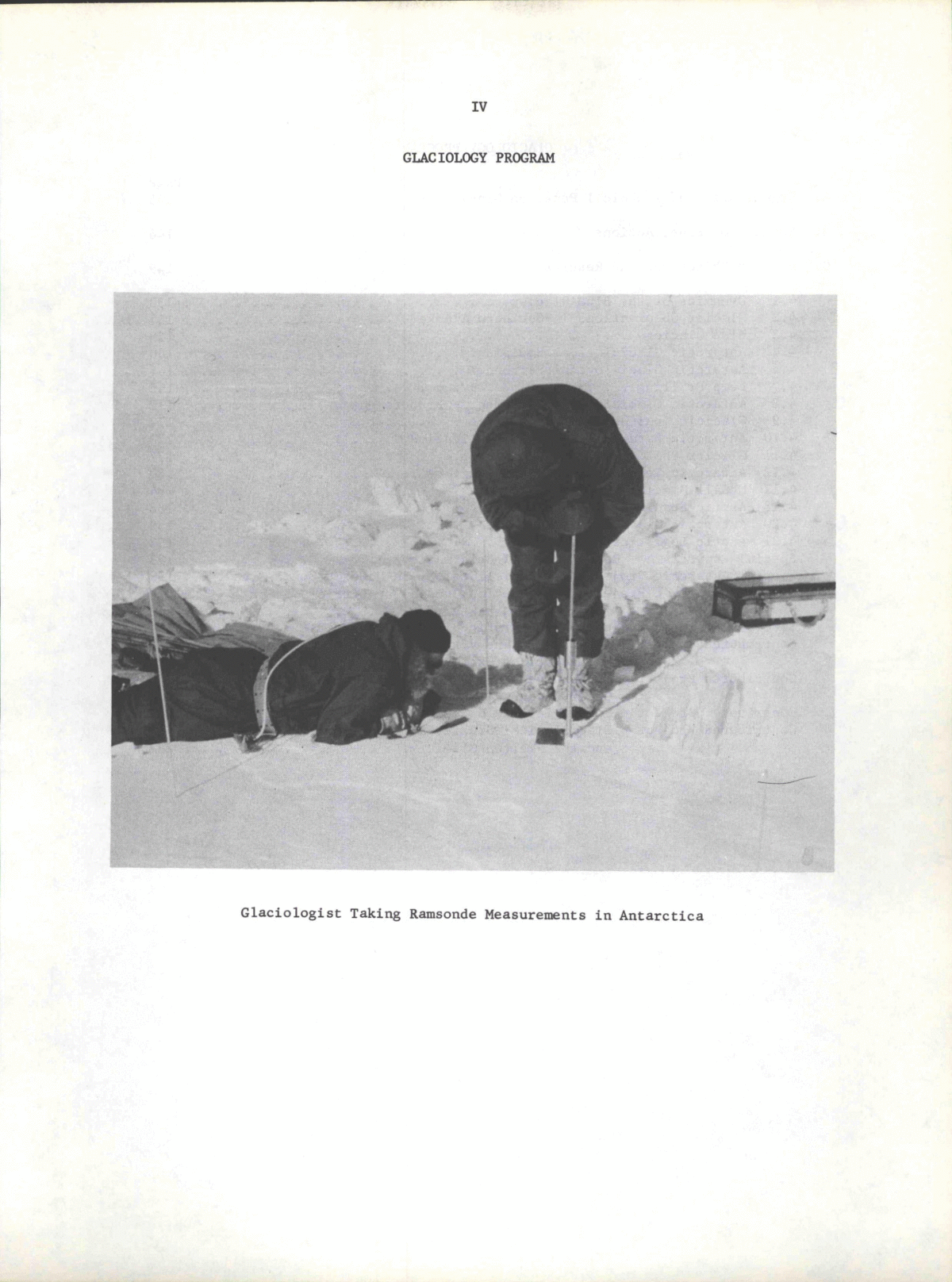
IV GLACIOLOGY PROGRAM G l a c i o l o g i s t Taking Ramsonde Measurements i n A n t a r c t i c a
GLACIOLOGY PROGRAM Page A, Organization of Technical Panel on Glaciology 145 B, Summary of Panel Actions 146 C, Project Objectives and Results 149 4.1 Dynamics of the Blue Glacier 150 4.2 Glacier Observations i n Southern Alaska 154 4.3 Blue Glacier 158 4.4 A n t a r c t i c G l a c i o l o g i c a l Equipment 160 4.5 A n t a r c t i c G l a c i o l o g i c a l Personnel 161 4.7 Deep D r i l l i n g 165 4.8 A n t a r c t i c G l a c i o l o g i c a l Equipment - Procurement 172 4.9 G l a c i o l o g i c a l Headquarters O f f i c e 172 4.10 A n t a r c t i c Data Reduction and P u b l i c a t i o n 173 4.11 Glacier Photogrammetry and Mapping 177 4.12 A n t a r c t i c Ice Sampling, Isotope Ratios 180 4.17 McCall Glacier, Brooks Range 184 4.18 A r c t i c Sea Ice Physics 188 4.20 A n t a r c t i c G l a c i a l Geology 189 4.21 A r c t i c L o g i s t i c s 192 Special Projects A - Ross Ice Shelf Deformation 193 Special A n t a r c t i c Project B - G l a c i a l Geology i n McMurdo Sound Area . . . 199 Special A n t a r c t i c Project C - Radiation Studies at L i t t l e America & the South Pole 210 Special A n t a r c t i c Project D - A n t a r c t i c B i o l o g i c a l Studies 214 Contributed Project - Description and Vari a t i o n s of Glaciers i n the United States Exclusive of Alaska 221 Contributed Project - Mt. Chamberlin-Barter Isl a n d G l a c i o l o g i c a l Observations, Alaska 225 Contributed Project - Juneau Ice F i e l d Research Project 228 Contributed Project - G l a c i o l o g i c a l Studies a t L i t t l e America and the Skelton Glacier 232 144
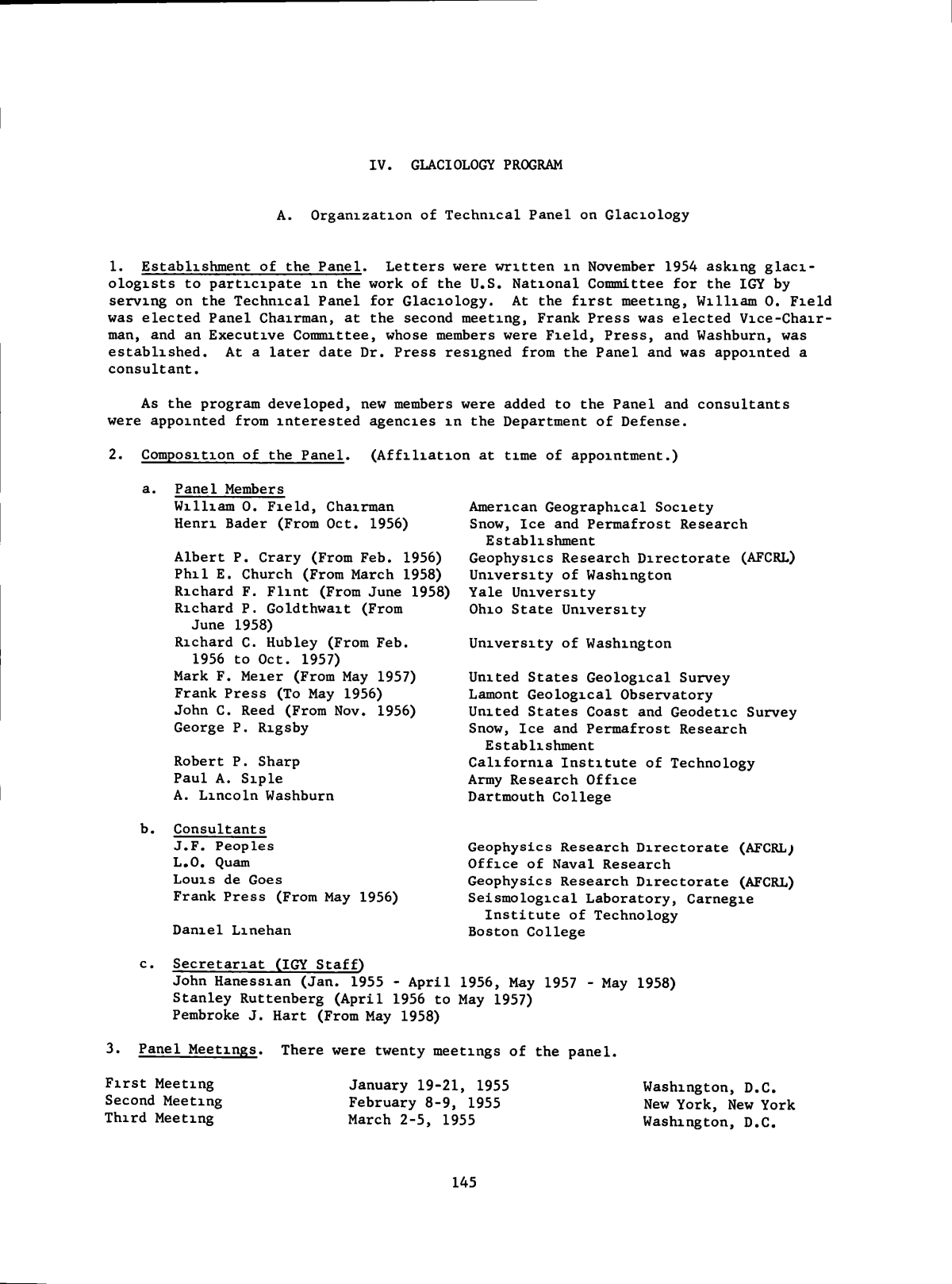
IV. GLACIOLOGY PROGRAM A. Organization of T e c h n i c a l Panel on Gl a c i o l o g y 1. Establishment of the Panel. L e t t e r s were w r i t t e n i n November 1954 asking g l a c i - o l o g i s t s to p a r t i c i p a t e i n the work of the U.S. National Committee for the IGY by se r v i n g on the T e c h n i c a l Panel for G l a c i o l o g y . At the f i r s t meeting, W i l l i a m 0. F i e l d was e l e c t e d Panel Chairman, at the second meeting, Frank P r e s s was e l e c t e d V i c e - C h a i r - man, and an E x e c u t i v e Committee, whose members were F i e l d , P r e s s , and Washburn, was e s t a b l i s h e d . At a l a t e r date Dr. P r e s s resigned from the Panel and was appointed a co n s u l t a n t . As the program developed, new members were added to the Panel and c o n s u l t a n t s were appointed from i n t e r e s t e d agencies i n the Department of Defense. 2. Composition of the Panel. ( A f f i l i a t i o n at time of appointment.) a. Panel Members W i l l i a m 0. F i e l d , Chairman Henri Bader (From Oct. 1956) A l b e r t P. Crary (From Feb. 1956) P h i l E. Church (From March 1958) Richard F. F l i n t (From June 1958) Richard P. Goldthwait (From June 1958) Richard C. Hubley (From Feb. 1956 to Oct. 1957) Mark F. Meier (From May 1957) Frank P r e s s (To May 1956) John C. Reed (From Nov. 1956) George P. Rigsby Robert P. Sharp Paul A. S i p l e A. L i n c o l n Washburn b. Consultants J . F . Peoples L.O. Quam Lo u i s de Goes Frank P r e s s (From May 1956) Da n i e l Linehan American Geographical S o c i e t y Snow, I c e and Permafrost Research Establishment Geophysics Research D i r e c t o r a t e (AFCRL) U n i v e r s i t y of Washington Y a l e U n i v e r s i t y Ohio S t a t e U n i v e r s i t y U n i v e r s i t y of Washington United S t a t e s G e o l o g i c a l Survey Lament G e o l o g i c a l Observatory United S t a t e s Coast and Geodetic Survey Snow, I c e and Permafrost Research Establishment C a l i f o r n i a I n s t i t u t e of Technology Army Research O f f i c e Dartmouth College Geophysics Research D i r e c t o r a t e (AFCRL; O f f i c e of Naval Research Geophysics Research D i r e c t o r a t e (AFCRL) S e i s m o l o g i c a l Laboratory, Carnegie I n s t i t u t e of Technology Boston College S e c r e t a r i a t (IGY S t a f f ) John Hanessian (Jan. 1955 - A p r i l 1956, May 1957 Stanley Ruttenberg ( A p r i l 1956 to May 1957) Pembroke J . Hart (From May 1958) May 1958) 3. Panel Meetings. There were twenty meetings of the panel. F i r s t Meeting Second Meeting T h i r d Meeting January 19-21, 1955 February 8-9, 1955 March 2-5, 1955 Washington, D.C. New York, New York Washington, D.C. 145
GLACIOLOGY Fourth Meeting August 29-30, 1955 Pasadena, C a l i f o r n i a F i f t h Meeting October 26-27, 1955 Washington, D.C. S i x t h Meeting February 2, 1956 Washington, D.C. Seventh Meeting A p r i l 28, 1956 Washington, D.C. Eighth Meeting September 28, 1956 Washington, D.C. Ninth Meeting November 13, 1956 Washington, D.C. Tenth Meeting February 13, 1957 Washington, D.C. Eleventh Meeting May 2, 1957 Washington, D.C. Twelfth Meeting September 20, 1957 Washington, D.C. T h i r t e e n t h Meeting November 12, 1957 Washington, D.C. Fourteenth Meeting February 6, 1958 Washington, D.C. F i f t e e n t h Meeting May 8, 1958 Washington, D.C. Sixteenth Meeting October 21, 1958 Washington, D.C. Seventeenth Meeting May 7, 1959 Washington, D.C. Eighteenth Meeting October 20, 1959 Washington, D.C. Nineteenth Meeting A p r i l 26, 1960 Washington, D.C. Twentieth Meeting March 20-21, 1961 Evanston, I l l i n o i s B. Suimnary of Panel Actions 1. Early Planning. The Glaciology Panel was concerned throughout i t s h i s t o r y w i t h the development of a program i n glaciology f o r the Northern Hemisphere and f o r Antarc- t i c a . Especially i n connection w i t h the a n t a r c t i c program, the Panel was concerned not only w i t h the development of a s c i e n t i f i c program, but also w i t h l o g i s t i c s , per- sonnel recruitment and t r a i n i n g , and provisions f o r data reduction. The IGY gl a c i o l o g y program e a r l y envisaged by the Panel included: a. De t a i l e d observations a t three s i t e s i n the Northern Hemisphere: Olympic Mountains; Juneau, Alaska; and Greenland Ice Cap. b. Reconnaissance observations i n Western U.S. and Alaska and I n the Canadian and Danish a r c t i c . c. Detailed observations at three s t a t i o n s i n A n t a r c t i c a ; L i t t l e America; Marie Byrd Land and South Pole. d. Oversnow traverses from the various a n t a r c t i c s t a t i o n s e. A i r l i f t e d traverses i n A n t a r c t i c a f . Study of deformation of Ross Ic e Shelf g. Deep d r i l l i n g (300 m) a t the s t a t i o n i n Marie Byrd Land 2. Additions to Program. a, A n t a r c t i c a . The i n i t i a l program was l a t e r expanded by the a d d i t i o n of two s t a t i o n s i n A n t a r c t i c a : Wilkes (on the Knox Coast) and E l l s w o r t h (on the Weddell Sea). Projects were also included f o r the study of the i c e - f r e e areas of A n t a r c t i c a ( e s p e c i a l l y i n McMurdo Sound and at Wilkes Station) included geomorphologic and g l a - c i a l geology, thermoluminescence, and b i o l o g i c a l studies. b. Northern Hemisphere Program. The northern hemisphere program was expanded i n coverage, e s p e c i a l l y by the establishment o f s t a t i o n s f o r d e t a i l e d studies f o r one (or more) a b l a t i o n cycles on McCall Glacier i n the Brooks Range of Alaska and on two d r i f t i n g s t a t i o n s (one ice f l o e , one ice island) i n the A r c t i c Ocean. 146
GLACIOLOGY 3. A d m i n i s t r a t i o n of Program. I n October 1955, a G l a c l o l o g i c a l Headquarters O f f i c e was established, as an AINA administered p r o j e c t , i n the o f f i c e s of the USNC-IGY, Crary and Hubley were m charge of t h i s o f f i c e . This o f f i c e served as the administra- t i v e arm of the Panel, e s p e c i a l l y regarding the problems of men, equipment, transpor- t a t i o n and communications i n A n t a r c t i c a . Crary d i r e c t e d the o f f i c e u n t i l h i s departure i n January 1957 f o r the A n t a r c t i c (where he was the c h i e f s c i e n t i s t f o r the g l a c i o l o g y program and Deputy Chief S c i e n t i s t f o r the U.S. A n t a r c t i c Program f o r 2-1/2 years); Hubley d i r e c t e d g l a c l o l o g i c a l headquarters u n t i l h i s departure i n the suiraner of 1957 fo r McCall Glacier; the o f f i c e was d i r e c t e d from that time u n t i l i t s c l o s i n g i n June 1959 by Diane Fisher. 4. SIPRE T r a i n i n g Program. Training f o r s i x c h i e f g l a c i o l o g l s t s f o r the f i r s t season of the IGY g l a c l o l o g i c a l program was provided under the d i r e c t i o n of SIPRE on the Greenland I c e Cap i n the summer of 1956. S i m i l a r t r a i n i n g was not provided f o r the second season men, i t being supposed that the period of overlap w i t h f i r s t season men i n A n t a r c t i c a would serve the same purpose. 5. S e l e c t i o n of G l a c i o l o g i c a l Personnel. The problem of r e c r u i t i n g personnel f o r the a n t a r c t i c program was discussed by the Panel and several methods were proposed t o i n - form groups of prospective p a r t i c i p a n t s . Notices were prepared and sent to many u n i - v e r s i t i e s at which there were a c t i v e departments i n geophysics or geology, l e t t e r s were w r i t t e n t o many senior s c i e n t i s t s , and panel members d i d what they could at t h e i r home i n s t i t u t i o n s to inform and i n t e r e s t q u a l i f i e d personnel. Stemming from the needs of the e n t i r e a n t a r c t i c program, a Personnel Selection Board was established by the USNC i n September 1955 to prepare questionnaires and procedures f o r s e l e c t i n g and reviewing candidates. The PSB reviewed candidates a f t e r t h e i r t e c h n i c a l competence was ascertained by the appropriate d i s c i p l i n e or p r o j e c t senior s c i e n t i s t . The PSB then reviewed medical information and the questionnaires and i n t e r v i e w reports as the basis f o r f i n a l s e l e c t i o n of personnel. 6. Mapping. I t was recognized that many of the programs i n A n t a r c t i c a would require base maps and/or a e r i a l photography. The Panel recommended th a t an e f f o r t be made to map sections of the continent, p a r t i c u l a r l y the Ross Ice Shelf, where there was a large amount of h i s t o r i c a l information. Several proposals were discussed through var- ious government channels but d i d not m a t e r i a l i z e . One mapping p r o j e c t , however, was undertaken i n which the American Geographical Society produced a map of A n t a r c t i c a on a scale of 1:3,000,000 at 70° Lat., and continued the p r o j e c t to produce a revised map a f t e r the f i r s t year of operations. 7. G l a c i o l o R i c a l Equipment. S t a t i o n g l a c i o l o g y and oversnow traverses were discussed m terms of equipment and supplies. The Panel requested SIPRE to recommend su i t a b l e and standardized equipment f o r snow and ice studies. I t was decided to employ the SIPRE standard g l a c l o l o g i c a l k i t s , which were to be purchased through the good o f f i c e s of SIPRE. Vehicles were also discussed i n terms of range, load c a p a b i l i t y , mainten- ance problems, a d a p t a b i l i t y to l i v i n g and working quarters, etc. 8. G l a c l o l o g i c a l Data Center. I n accordance w i t h the recommendations of the t h i r d meeting of CSAGI, Brussels 1955, plans were evolved i n the U.S. f o r IGY World Data Centers i n a l l IGY d i s c i p l i n e s . At the request of CSAGI, the Glaciology Panel evolved d e t a i l e d recommendations regarding the form f o r submission of data from g l a c i o l o g i c a l observations to the IGY World Data Centers. With some mod i f i c a t i o n s , these recommen- dations were adopted by the CSAGI World Data Center Meeting, UCCLE, 1957, and were p r i n t e d i n the CSAGI Guide t o World Data Center (IGY Annals, v o l . V I , pp. 289-297). The IGY Data Center f o r Glaciology was established i n the American Geographical Society under the d i r e c t i o n of W i l l i a m 0. F i e l d . The center formally began operation July 1, 1957. I n a d d i t i o n to c o l l e c t i n g and exchanging data and reports according to 147
GLACIOLOGY CSAGI recommendations, the data center has acquired a considerable number of photo- graphs of g l a c i e r s from the period of f i f t y years p r i o r to IGY. The data center es- tablished a series of " G l a c i o l o g i c a l Reports" which made possible the p u b l i c a t i o n and dissemination of preliminary reports and reports containing d e t a i l e d information and data not o r d i n a r i l y published i n s c i e n t i f i c j o u r n a l s . The Glaciology Panel endorsed t h i s p u b l i c a t i o n and urged data centers to encourage a l l authors of a r t i c l e s i n the report series to prepare s u i t a b l e versions of the same m a t e r i a l f o r p u b l i c a t i o n i n standard s c i e n t i f i c j o u r n a l s . With the concurrence of the Glaciology Panel, the data center has issued since January 1960 a mimeographed q u a r t e r l y b u l l e t i n e n t i t l e d "Gla- c i o l o g i c a l Notes," a compilation of current items of information to g l a c i o l o g i s t s i n - cluding a c q u i s i t i o n s of the data center, o u t l i n e s of current g l a c i o l o g i c a l programs, notices of meetings of probable i n t e r e s t to g l a c i o l o g i s t s , b i b l i o g r a p h i e s (and a v a i l - able t r a n s l a t i o n s ) , etc. 9. Data Reduction. Owing to the way the a n t a r c t i c program was organized, i t was nec- essary to make provisions f o r the routine reduction of data taken i n A n t a r c t i c a under the g l aciology program except f o r the SIPRE deep d r i l l i n g program, f o r these data were to be worked up at SIPRE. Data reduction centers were established at the Ohio State U n i v e r s i t y under the d i r e c t i o n of R.P. Goldthwait f o r the g l a c i o l o g i c a l observations and at the U n i v e r s i t y of Wisconsin under the d i r e c t i o n of CP. Woollard f o r the seis- mic, gravimetric and magnetic observations from the oversnow and a i r l i f t e d traverses. Data from northern hemisphere programs were reduced at the home i n s t i t u t i o n s of the groups that had c a r r i e d out the p r o j e c t s . 10. Continuation of Panel. A f t e r the IGY program was over, the Panel made recommen- dations f o r 1959 programs to be included i n the U.S. program f o r IGC-1959. These were mainly the continuation of programs already i n being but the Panel gave i t s support to the i n i t i a t i o n of new work such as a e r i a l photogrammetry on a large scale i n Alaska and western U.S. and to beginning a g l a c i o l o g i c a l f i e l d program i n the department of geology. U n i v e r s i t y of Alaska. The Panel also f e l t that inasmuch as the IGY had given considerable impetus to expanding U.S. work i n glaciology, and that glacio'logists were not w e l l organized i n the U.S., the Panel might serve as a useful o r g a n i z a t i o n a l me- dium i n the f u t u r e . Accordingly, the Panel requested that i t be kept i n t a c t and ac- t i v e , t h i s was accomplished by i n c o r p o r a t i n g the Panel i n t o the Academy's Committee on Polar Research, and by using e s s e n t i a l l y the same membership as an advisory group to the g l a c i o l o g y data center sub-section of IGY World Data Center A. 148
GLACIOLOGY C. Project Objectives and Results 1. Summary of Program. The U.S. Program i n glac i o l o g y was devoted to two major pro- grams, one i n the Northern Hemisphere, i n c l u d i n g Western United States, Alaska, and some preparatory work m Greenland, c a r r i e d out by SIPRE (now CRREL), and a broad program i n the A n t a r c t i c . I n a d d i t i o n to the pr o j e c t s supported by the USNC, there were several programs being c a r r i e d out under the auspices of other agencies, where the work was d i r e c t l y r e l a t e d to the o v e r - a l l IGY obj e c t i v e s . Through the cooperation of these agencies, these programs were included m the U.S. c o n t r i b u t i o n t o the IGY, and the data were made av a i l a b l e to the IGY World Data Centers. 2. Order of Project Description. The proj e c t s that are described i n the f o l l o w i n g pages are i n numerical order to correspond w i t h the o r i g i n a l formulation of the pro- gram. For convenience, the proj e c t s are grouped below to r e f l e c t s i m i l a r i t y of pur- pose. Northern Hemisphere Program 4.1, 4.2, 4.3, 4.11, 4.17, 4.18, 4.21, and contributed p r o j e c t s A n t a r c t i c Program 4.4, 4.5, 4.7, 4.8, 4.10, 4.12, and special p r o j e c t s A through D Administration 4.9 3. Cancelled Projects. Former p r o j e c t s bearing the f o l l o w i n g numbers were e l i m i n - ated from the program or combined w i t h other p r o j e c t s : 4.6, 4.13 through 4.16 and 4.19. 149
GLACIOLOGY Project 4.1 - Dynamics of the Blue Glacier 1. Objectives. These i n v e s t i g a t i o n s , under the cognizance of the Department of Ge- ology, C a l i f o r n i a I n s t i t u t e of Technology, were designed to provide data that would permit an analysis and i n t e r p r e t a t i o n of the st r u c t u r e and of the mode and mechanism of flow occurring i n the r e l a t i v e l y simple i c e tongue of the Blue Glacier, Olympic Mountains, Washington. 2. Operations. U n i v e r s i t y of Washington personnel (see pr o j e c t 4.3) established a hut i n the accumulation area, s u f f i c i e n t l y protected to permit year-round occupation, f o r a study of the energy and mass budget of the g l a c i e r i n r e l a t i o n to i t s meteoro- l o g i c a l environment. This i n s t a l l a t i o n was b e n e f i c i a l to the summer program of work under the Caltech p r o j e c t w i t h respect to some l o g i s t i c a l assistance, sample c o l l e c - t i o n , and spot observations. The lower part of the g l a c i e r was v i s i t e d m the summers of 1957 and 1958 by Cal- tech s c i e n t i s t s who set up a temporary camp, w i t h permission of the National Park Ser- v i c e , alongside the ice tongue. Equipment was already a v a i l a b l e through a p r i o r loan from the O f f i c e of Naval Research, through the cooperation of the U.S. A i r Force and the U.S. Coast Guard supplies and equipment were air-dropped and, i n some instances, landed. The programs c a r r i e d out f e l l i n t o several categories: a. Boring Operations. Important to seismic operations and s e t t i n g of stakes, as w e l l as f o r the obtaining of samples, was the equipment to bore holes i n the i c e . The SIPRE manual ice auger (2.5 cm) was instrumental i n preparing the small diameter holes. With experience, one man could d r i l l an 8 m hole i n about an hour. Some 300 m of 2.5 cm diameter holes were bored the f i r s t summer, l a r g e l y f o r shot holes. The Equip- ment Development Laboratory, Water Resources D i v i s i o n , U.S. Geological Survey, devel- oped a gasoline-driven, hand-held auger f o r 4.4 cm diameter holes. About 100 3.3 m holes were d r i l l e d w i t h t h i s equipment, which was some three to eight times f a s t e r than hand methods, depending on ice conditions. Hot-point boring proved troublesome, but the problems were solved w e l l enough t o permit successful use of t h i s method to d r i l l both a 400 and a 740 foot hole the f i r s t season and a 720 foot hole down-glacier and a 590 foot hole up-glacier the second season. Some problems, notably ice forma- t i o n on the i n t e r i o r w alls of the pipe i n the hole, continued to plague the e f f o r t s , l i m i t i n g inclinometer surveys to 400 and 250 feet r e s p e c t i v e l y . Neither i n 1957 nor i n 1958 could a hole be bored to the bottom of the i c e . I t i s i n f e r r e d that a layer of ice r i c h m rocks and other d e t r i t u s was encountered t h a t made d r i l l i n g so slow th a t I t had to be terminated. b. Seismic Survey. Small charges (cap plus a few cc of dynamite) were used at 35 s t a t i o n s ; recording was accomplished w i t h a s i x - t r a c e Century Geophysical seismic set, which could be broken i n t o components small enough to backpack. Refraction studies were made at two s t a t i o n s and r e f l e c t i o n at the remainder. Severe problems were encountered w i t h badly crevassed i c e , v a l l e y - w a l l r e f l e c t i o n s , and the presumed hi g h l y i r r e g u l a r f l o o r of the g l a c i e r . However, a large volume of usable data was obtained and studied at Pasadena. The greatest ice thickness found was 280 m, near the center l i n e of the g l a c i e r , a l i t t l e below the f i r n l i m i t ; a seismic v e l o c i t y of 3650 m/sec was determined f o r the i c e . c. Surface Flow-Velocity Network. I n 1957, 49 poles were established i n a series of e i g h t traverse p r o f i l e s across lower Blue Glacier from j u s t above the snout to a l i t t l e above the f i r n l i m i t . Their p o s i t i o n was determined by t h e o d o l i t e observations from a series of survey s t a t i o n s on bedrock and stable moraine alongside the g l a c i e r . Preliminary data suggest a maximum v e l o c i t y i n the flow c e n t e r - l i n e of about 15 cm/day. Ab l a t i o n at these poles was about 30 cm/week during August 1957 and was s u r p r i s i n g l y uniform over the e n t i r e g l a c i e r below the f i r n l i m i t . The re-survey of t h i s network 150
GLACIOLOGY of poles every year w i l l r e s u l t i n a determination of the vector flow f i e l d of the surface. Some of the stakes were reset i n 1958 f o r observations at new locations. d. Ice P e t r o f a b r i c s . Exploratory studies i n 1957 included a general survey of the f a b r i c s and r e l a t i o n s h i p to the well-marked f o l i a t i o n p a t t e r n , a search f o r r e - l a t i o n s between ice and f a b r i c types, and the l a t e r a l persistence and s i g n i f i c a n c e of multiple-maxima-type f a b r i c s . e. Study of Structures. Megascopic structures on the g l a c i e r , such as f o l i a t i o n , f a u l t s and drag f o l d s are w e l l developed and c l e a r l y displayed. Detailed mapping was c a r r i e d out of a double (side-by-side) spoon-shaped s t r u c t u r e , which appears from be- neath the f i r n and seemingly extends to the snout; i t i s presumed that these s t r u c - tures are manifestations of the i c e - f l o w p a t t e r n . A plane-table map (1:1200) was made of a s t r i p 1700 feet wide and 2700 feet long extending transversely across the g l a c i e r j u s t below the f i r n l i m i t . f . Oxygen-Isotope Ratios. Samples of snow, f i r n and i ce were c o l l e c t e d at s i t e s ranging from the g l a c i e r ' s terminus t o w e l l up i n the f i r n basins. U. of Washington personnel c o l l e c t e d samples of snow as i t f e l l on the Snow Dome and resampled these layers some months l a t e r . Samples were taken also from p i t s and a core hole. Anal- y s i s of OÌ /ÌOÌ ^ r a t i o s was c a r r i e d out at Cal Tech. 3. Personnel. R.P. Sharp was p r o j e c t d i r e c t o r . C.R. A l l e n and W.B. Kamb, Cal. Tech., J.C. Savage of M.I.T., and M.F. Meier, U.S. Geological Survey, were the senior scien- t i s t s associated w i t h the f i e l d work. A number of graduate students also p a r t i c i p a t e d . The oxygen isotope r a t i o s were determined by S. Epstein of Cal. Tech. 4. Data. Several reports on f i e l d a c t i v i t i e s were submitted to the IGY World Data Center and papers have been prepared f o r the l i t e r a t u r e . 5. Results. a. Seismic. The three-dimensional geometry of the lower ice tongue and the con- f i g u r a t i o n of the rock f l o o r upon which i t rests have been determined by seismic r e - f l e c t i o n s at 19 out of the 32 s t a t i o n s occupied on the g l a c i e r from near the terminus to the f i r n l i m i t . Maximum thickness of ice sounded, a l i t t l e over 270 meters i s near the f i r n l i m i t . b. Flow. A crude preliminary p l o t t i n g of the component of movement p a r a l l e l to the surface shows maximum v e l o c i t i e s at the f i r n l i n e and a progressive decrease t o - ward the snout, as c l a s s i c a l theory would p r e d i c t . Along any transverse p r o f i l e the c e n t r a l two-thirds of the g l a c i e r moves w i t h a r e l a t i v e l y uniform v e l o c i t y , and the highest v e l o c i t y gradients occur i n narrow zones along each margin of the ice tongue. c. Deep Bore Holes. Five e s s e n t i a l l y v e r t i c a l bore holes w i t h depths of 120 to 325 meters have been made i n a reach of the g l a c i e r j u s t below the f i r n l i m i t . De- formation of pipes i n these holes w i l l u l t i m a t e l y give useful data on the v e r t i c a l d i s t r i b u t i o n of flow v e l o c i t y m t h i s i c e body. So f a r data are fragmentary owing to unexpected ice obstructions inside the pipe. As a n t i c i p a t e d , " g r a v i t y " flow curves w i t h greatest v e l o c i t y at the surface have so f a r been recorded. d. The data from items a, b and c above, plus i n f o r m a t i o n on the shape, size and slope of the g l a c i e r surface as determined from a d e t a i l e d and w e l l - c o n t r o l l e d topo- graphic map, w i l l give both information and opportunity to t e s t various flow laws and to evaluate constants t h e r e i n . e. Fabrics. Fabric diagrams showing the o p t i c a l o r i e n t a t i o n of c r y s t a l s m var- ious d i f f e r e n t kinds of ice and i n d i f f e r e n t s t r u c t u r a l s i t u a t i o n s have been made on the lower Blue Glacier. These i n v e s t i g a t i o n s lead to the f o l l o w i n g conclusions: 151
GLACIOLOGY ( i ) Fine granular i c e masses i n the Blue Glacier c o n s i s t e n t l y have a dispersed but c l e a r l y centered f a b r i c w i t h the pole perpendicular to the plane of f o l i a t i o n . ( i i ) Strong f a b r i c s w i t h well-defined m u l t i p l e maxima (3 to 4 i n number) have a consistent geometrical r e l a t i o n to the f o l i a t i o n and to the i n f e r r e d predominant shear stress. No theory yet proposed gives an adequate explanation of the m u l t i p l e - maxima f a b r i c s , but t h e i r v a l i d i t y cannot be doubted. ( i l l ) Fabrics i n other parts of the g l a c i e r i n i ce of d i f f e r e n t s t r u c t u r e s c l e a r l y d i f f e r from the multiple-maxima f a b r i c s , but some may represent an e a r l y stage i n the development of m u l t i p l e maxima. f. Map. A d e t a i l e d s t r u c t u r a l map has been made of the lower ice tongue showing the i n d i v i d u a l streams composing t h i s body, and the moraines, f o l i a t i o n , ogives, cre- vasses, and r e l a t e d features. The most important s t r u c t u r a l feature appears to be a l o n g i t u d i n a l septum of ice which i s e s p e c i a l l y r i c h i n f i n e granular m a t e r i a l , w e l l f o l i a t e d , and s t r u c t u r a l l y complex i n d e t a i l . This separates a double spoon-shaped f o l i a t i o n i n the ice streams on e i t h e r side. The spoon-shaped f o l i a t i o n and septum are believed to o r i g i n a t e i n or near the base of the ice f a l l separating lower Blue Glacier from i t s p r i n c i p a l accumulation basins. Formation of ogives, here an i n t e r n a l s t r u c t u r a l feature, i s judged to be c l o s e l y r e l a t e d i n space, time, and o r i g i n w i t h the c r e a t i o n of the spoon-shaped f o l i a t i o n . The gradual appearance of secondary sets of f o l i a t i o n f a r t h e r down the g l a c i e r tends to confuse and even p a r t i a l l y e l i m i n a t e the double-spoon f o l i a t i o n p a t t e r n and the ogives. 16 18 g. 0 /O Data from oxygen-isotope analyses are as yet incomplete and confus- in g , but they confirm the impression that the winter environment of the Blue Glacier I S , without notable exceptions, moderately warm. The analyses also suggest t h a t much, perhaps most, of the f m e - i c e f o l i a , lenses and masses w i t h i n the ice tongue represent p r i n c i p a l l y f i l l i n g s of snow i n crevasses formed l a r g e l y i n the ice f a l l . Other bodies of f i n e i c e may be the product of g r a n u l a t i o n during movement, but t h i s has not yet been convincingly demonstrated. The oxygen-isotope r a t i o s suggest that the process of forming coarse-grained clear blue i c e , whatever i t may be, r e s u l t s i n a s l i g h t impov- erishment i n the 0^^ atom. The p r i n c i p l e that the 0/0^° r a t i o o f snow i s c o n t r o l l e d i n part by the e l e v a t i o n at which i t accumulates i s confirmed by Blue Glacier data. However, the isotope r a t i o s w i t h i n the ice tongue of lower Blue Glacier are much more uniform than might be expected, and t h i s apparent homogenization has not yet been sat- i s f a c t o r i l y explained. h. S i g n i f i c a n t developments i n the design and co n s t r u c t i o n of hot points f o r thermal boring of deep holes and i n the technique of t h e i r operation have been made. 6. Bibliography. a. Papers Presented at Meetings. C.R. A l l e n , W.B. Kamb, M.F. Meier, R.P. Sharp: "Studies of the Lower Blue Glacier, Washington." F o r t y - F i r s t Annual Meeting, American Geophysical Society, A p r i l 1960, Washington, D.C., and X l l t h General Assembly, lUGG, August 1960, H e l s i n k i . R.L. Shreve: "The Borehole Experiment on Blue Glacier, Washington." X l l t h General Assembly, lUGG, August 1960, H e l s i n k i . (Abstract pub. Comm. Snow and I c e , lUGG X I I Gen. Ass.. pp. 53-4). W.B. Kamb: "Ice P e t r o f a b r i c s Data i n Relation to the Structure of Blue Glacier, Mt. Olympus, Washington." X l l t h General Assembly, lUGG, August 1960, H e l s i n k i . 152
GLACIOLOGY Published Papers. W. Barclay Kamb: "Ice P e t r o f a b r i c Observation from Blue Glacier, Washington, i n R e l ation t o Theory and Experiment." JGR, v o l . 64, no. 11, Nov. 1959, pp. 1891-1909. R.P. Sharp: " I n v e s t i g a t i o n s of Glacier Dynamics on the Blue Glacier (1957)." IGY Glaciology Report Series. No. 1, July 1958, WDC-A, Glaciology, Am. Geog. Soc, N. Y, R.P. Sharp, S. Epstein, I . Vidziunas: "Oxygen-Isotope Ratios i n the Blue Glacier, Olympic Mountains, Washington, U.S.A." JGR. v o l . 65, no. 12, Dec. 1960, pp. 4043-59. C.R. A l l e n , W.B. Kamb, M.F. Meier, R.P. Sharp: "Structure of the Lower Blue Glacier," Journal of Geology, v o l . 68, no. 6, 1960, pp. 601-625. R.L. Shreve: "Theory of Performance of Isothermal Solid-Nose Hot Points f o r Boring m Temperate I c e . " JGR, v o l . 4, 1962, pp. 151-160. R.L. Shreve and R.P. Sharp: "Borehole Operations and Observation on the Blue Glacier, Olympic Mountains, Washington, U.S.A." ( I n prep.) M.F. Meier, C.R. A l l e n , W.B. Kamb and R.P. Sharp: "Surface V e l o c i t y and Sur- face-Strain Data from Lower Blue Glacier, Washington." ( I n prep.) R.L, Shreve: "The Borehole Experiment on Blue Glacier, Washington." I n t ' 1 . Asso. Sci.. Hydro.. Publ. 54, 1960, pp. 530-531. 153
GLACIOLOGY Project 4.2 - Glacier Observations i n Southern Alaska 1. Ob.iectives. This p r o j e c t at the American Geographical Society, New York, had as I t s basic o b j e c t i v e the study of the behavior of g l a c i e r s i n southern Alaska as i n - dicated p r i m a r i l y by changes i n t h e i r terminal areas. Both b o t a n i c a l and g e o l o g i c a l evidence was studied and comparative observations made by means of photography and surveys. The observations were cor r e l a t e d w i t h those made i n the past and w i t h such information as could be derived from a study of a e r i a l photographs. E x i s t i n g points of reference were re-established and where desirable f o r f u r t h e r observations, new ones were located. 2. Operations. a. I n the summer of 1957, a f i e l d party v i s i t e d the f o l l o w i n g l o c a t i o n s : ( i ) Kenai Mountains 21 v a l l e y g l a c i e r s (one iss u i n g from Harding I c e f i e l d , 8 from Sargent I c e f i e l d , and 8 from the n^v^ at the head of the Blackstone and Spen- cer Glaciers. Of these 6 reach tidewater and 8 others to w i t h i n 100 m. of sea l e v e l . ) ( i i ) Chugach Mountains 22 prominent g l a c i e r s were v i s i t e d of which 13 are t i d a l , s i x termin- ate w i t h i n 100 meters of sea l e v e l , and 3 are m i n t e r i o r v a l l e y s . ( i l l ) Alaska Range (Muldrow Glacier of Mt. McKinley and four g l a c i e r s of the Delta River area) ( i v ) Wrangell Mountain (Kennecott G l a c i e r ) . Observations included determination of present state of a c t i v i t y , measurement or q u a l i t a t i v e assessment of changes i n length and volume since the previous observa- t i o n s , determination of age of the terminal moraine formed at the time of the l a s t maximum advance, and of recessional moraines and in t e r v e n i n g deglaciated areas i n or- der to determine rates of recession; and determination of the e l e v a t i o n of the f i r n l i m i t . Some a e r i a l photography undertaken by the Navy supplemented these observations. b. I n 1958 the observations were extended to the f o l l o w i n g areas i n southeastern Alaska: ( i ) Glacier Bay. The National Park Service vessel NUNATAK was made av a i l a b l e f o r a 20 day v i s i t to a l l the accessible t e r m i n i . F i f t e e n of the larger v a l l e y g l a - c i e r s and many of the smaller g l a c i e r s were photographed and surveyed. Of these, 9 are t i d a l and 8 reach to w i t h i n 100 m. of sea l e v e l . Of the 84 survey and/or photo s t a t i o n s occupied, 58 had previously been established and 26 were newly located. Con- t i n u i t y was maintained w i t h a series of photographs and surveys begun i n 1890. Gla- c i a l geology i n v e s t i g a t i o n s i n v o l v i n g s t r a t i g r a p h i c studies and radiocarbon dating were also c a r r i e d out by Dr. Goldthwait to determine the p o s t g l a c i a l chronology i n the area. ( i i ) Coast Mountains. Twelve g l a c i e r s m the Coast Mountains and 2 i n the adjacent parts of the St. E l i a s Mountains were also v i s i t e d . Of these 3 are t i d a l and 5 reach w i t h i n 100 m. of sea l e v e l . 8 of the g l a c i e r s have been observed p e r i - o d i c a l l y i n recent decades and have w e l l established networks of photo-survey st a - t i o n s , new s t a t i o n s were established f o r f u r t h e r reference at the remaining 6 g l a c i e r s . The p r i n c i p a l g l a c i e r s v i s i t e d were Davidson Glacier on the west side of Lynn Canal, the Eagle Herbert and Mendenhall Glaciers near Juneau; Taku, N o r r i s , and Hole-in-the- Wall Glaciers i n Taku I n l e t and V a l l e y , Sawyer and South Sawyer Glaciers i n Tracy 154
GLACIOLOGY Arm; and North Dawes and Dawes Glaciers i n Endicott Arm. Observations of some of these g l a c i e r s were begun i n the 1880's. ( i l l ) F l i g h t s were made i n the f o l l o w i n g areas to photograph g l a c i e r t e r m i n i and r e l a t e d features: (a) L i t u y a Bay and the western slope of the Fairweather Range on July 11 to observe the e f f e c t s of the July 9 earthquake. (b) Taku River and I n l e t , and Mendenhall, Herbert and Eagle Glaciers, northwest of Juneau, to supplement observations on the ground. (c) T s i r k u , Takhin, K l e h i n i and C l i l k a t River v a l l e y s , where the g l a - c i e r s are d i f f i c u l t of access by ground p a r t i e s and have not been v i s i t e d f o r many years. 3. Personnel. W.O. F i e l d was p r o j e c t supervisor and p r i n c i p a l i n v e s t i g a t o r , asso- ciat e d w i t h Mr. F i e l d were Dr. Jack Major, U n i v e r s i t y of C a l i f o r n i a , L e s l i e and Ele- anor V i e r i c k , U n i v e r s i t y of Colorado and subsequently U n i v e r s i t y of Alaska, Robert J. Goodwin, Bureau of Public Roads, Alaska; Charles C. Morrison, and Mane T. Hatcher, AGS; Dr. Richard P. Goldthwait and John Cornejo, Ohio State U n i v e r s i t y , Marion T. M i l l e t t , Brigham Young U n i v e r s i t y . Austin Post of Project 4.11 was responsible f o r some of the a e r i a l photography. 4. Data. Reports and photographs w i l l be submitted to the IGY World Data Center A - Glaciology as soon as the examination of m a t e r i a l i s concluded, 5. Results. The work was continued i n 1959, under NSF sponsorship, to v i s i t new s i t e s and r e v i s i t some of those explored i n 1957/58. Sit e s e l e c t i o n was on the basis of (a) areas where observations had not been made and where there was believed to be a serious gap i n the coverage during the IGY, (b) g l a c i e r s where the nature of the change seen i n previous years warranted f u r t h e r observations and (c) areas where from past experience g l a c i e r s were believed l i k e l y to be aff e c t e d by the earthquake of July 9, 1958, Only a preliminary o u t l i n e can as yet be given of the observations made m 1957-58. I n several of the l o c a l i t i e s i n the i n t e r i o r , no previous systematic observations had been attempted, so there were few i f any reference points a v a i l a b l e f o r q u a n t i t a t i v e measurements. At other l o c a l i t i e s , many previous observations had been made. I n general, the g l a c i e r s of the i n t e r i o r mountain ranges and of the v a l l e y s on the i n l a n d slope of the coastal mountains were found to be i n a state of recession. One important exception was the Muldrow Glacier, about 63 km long, which flows from the slopes of Mt. McKinley i n the Alaska Range. Beginning i n the winter of 1956-57, i t s lower 39 km was transformed i n t o great a c t i v i t y , which, so f a r as records show, has been unprecedented during the l a s t h a l f century. Marked changes i n the el e v a t i o n of the ice surface, both p o s i t i v e and negative, occurred, and the terminus, which had previously been v i r t u a l l y stagnant, advanced several hundred m. during the year. With- i n a few months parts of the g l a c i e r moved 6.6 km. These changes which were studied by a number of s c i e n t i s t s , were photographed and surveyed, and reference points were established f o r f u t u r e observations. I n the Chugach and Kenai Mountains along the coast of Prince W i l l i a m Sound, sur- vey and photographic s t a t i o n s established between 1899 and 1910 were reoccupied. Sys- tematic observations have been c a r r i e d out at these s i t e s since then and by the p r i n - c i p a l i n v e s t i g a t o r i n 1931 and 1935, so comparative q u a n t i t a t i v e and q u a l i t a t i v e measurements were possible f o r a determination of behavior patterns during the l a s t few decades. Further studies were c a r r i e d out to determine the age of the l a s t max- imum advance i n t o mature f o r e s t and the rate of subsequent recession. Because of 155
GLACIOLOGY the known chronology of change i n the l a s t h a l f century, a d d i t i o n a l data could also be obtained on the r a t e at which vegetation and p a r t i c u l a r l y trees become seeded i n areas vacated by the i c e . Although the climate of the area i s e s s e n t i a l l y c o a s t a l , there are considerable l o c a l v a r i a t i o n s . The sources of the g l a c i e r s are i n mountains ranging from 1200 to 4000 m i n height, so that g l a c i e r s w i t h both r e l a t i v e l y high and low l e v e l nlv^s are represented. The f i r n l i m i t ' v a n e s i n e l e v a t i o n m d i f f e r e n t places from as low as 450 m to over 1200 m. On the coastal slope most v a l l e y g l a c i e r s descend to w i t h i n 100 m of sea l e v e l , and 15 g l a c i e r s terminate i n a c t i v e l y discharging t i d a l i c e f r o n t s . These fa c t o r s c o n t r i b u t e to a wide d i v e r s i t y of morphological types, regimen, and area- e l e v a t i o n r e l a t i o n s h i p s . I t f o l l o w s , t h e r e f o r e , that g l a c i e r behavior i s r e l a t i v e l y v a r i e d and complex. Only a few of the g l a c i e r s i n the Prince W i l l i a m Sound area are receding r a p i d l y . The t e r m i n i of several g l a c i e r s have been r e l a t i v e l y stable f o r several decades, while others have had spasmodic advances interspersed w i t h periods of recession, and four of the larger g l a c i e r s have been more advanced during the 20th century than f o r at least several centuries. The most conspicuous features of g l a c i e r behavior i n t h i s area of southern Alaska are the long and short-term advances which have been recorded i n the l a s t h a l f century. Vegetation studies have indi c a t e d that three of the large t i d a l g l a c i e r s , the Meares, Harvard, and Harriman, were more advanced i n 1957-58 than they have been f o r at least several hundred years, possibly f o r several thousand years. Columbia Glacier, also t i d a l , advanced i n t o trees over 400 years old i n the f i r s t quarter of the present century and has subsequently receded a maximum of only a few hundred meters. During the present century, Bryn Mawr Glacier has had two surges i n t o trees over 50 years o l d and i s now receding from i t s l a t e s t outer p o s i t i o n . Bainbridge Glacier continues to terminate only a few tens of meters from i t s maximum p o s i t i o n a ttained i n the 19th century. The r e l a t i v e s t a b i l i t y of many of the g l a c i e r s i n Prince W i l l i a m Sound during the past h a l f century i s i n marked contrast to the behavior of most of the g l a c i e r s i n other parts of Alaska. There has been no wholesale withdrawal during the l a s t cen- tu r y or two, as has been the case i n many other areas. With some exceptions, the g l a c i e r s issuing from n^vls over 1500 m i n e l e v a t i o n have advanced or changed very l i t t l e since 1935. However, the g l a c i e r s w i t h n^v^s mostly below 1500 m have tended to recede. Conditions i n southeastern Alaska where the 1958 observations were c a r r i e d out are rather d i f f e r e n t . Several g l a c i e r s , the L i t u y a , C r i l l o n , Taku, Baird and probably the La Perouse and Brady, are f a r t h e r forward than they were i n the 18th century, while others are withdrawing from recent maxima i n which mature f o r e s t was invaded. However, i n strong contrast i s the approximately 100 km recession which has taken place i n Glacier Bay since the middle of the 18th century. The extent and r a p i d i t y of d e g l a c i a t i o n i n t h i s area appears unequalled elsewhere on earth. Here some of the p r i n c i p a l g l a c i e r s continue to recede r a p i d l y (the Muir, Geikie, and Hugh M i l l e r ) whereas others have remained r e l a t i v e l y stable i n recent decades (the Reid, Lamplugh, Margerie, Rendu, C a r r o l l and Casement) and two are from one to two kilometers f a r t h e r advanced than three decades ago (the Johns Hopkins and Grand P a c i f i c ) . During recent decades a number of small hanging g l a c i e r s m several i n l e t s have also experienced spasmodic advances or surges, some apparently of a r e c u r r i n g nature. These varied behavior patterns, and p a r t i c u l a r l y the instances of long and short- term advances, make southern Alaska one of the most i n t e r e s t i n g and p r o f i t a b l e areas f o r studying g l a c i e r behavior i n the whole of North America, The chronology of these advances - long term, spasmodic, and r e c u r r i n g - are being determined from a v a i l a b l e evidence and w i l l be c o r r e l a t e d i n an e f f o r t to 156
GLACIOLOGY determine possible r e l a t i o n s h i p s and f o r a study of the causative f a c t o r s involved. Attempts are also being made to determine to what extent they may be r e l a t e d to s i m i - l a r advances known to have occurred elsewhere i n Alaska and adjacent parts of Canada, as w e l l as i n other parts of the world, notably the Alps, where g l a c i e r chronology i s comparatively w e l l known since the 17th century. 6. Bibliography. a. Papers Presented at Meetings. Richard P. Goldthwait: "Post-Wisconsin G l a c i a l Changes i n Southeast Alaska." Tenth Alaskan Science Conference, Juneau, 1959. Richard P. Goldthwait: "Dating the L i t t l e Ice Age i n Glacier Bay, Alaska." I n t e r n a t i o n a l Geological Congress, Copenhagen, 1960. Wi l l i a m 0. F i e l d : "Some Recent Observations o f Glacier Behavior i n Alaska." Tenth Alaskan Science Conference, June 1959. b. Published Papers. W.O. F i e l d : "Observations of Glacier Behavior m Southern Alaska, 1957." IGY Glac. Rep. Series, No. 1, IGY World Data Center - A, Glaciology, Am. Geograph. Society, New York, July 1958. "Observations of Glacier V a r i a t i o n s i n Glacier Bay, Southeastern Alaska, 1958 and 1961, Preliminary Report." American Geographic Society, New York, June 1964. "Maps o f Glacier Termini i n Southern Alaska, F i r s t Series." American Geo- graphic Society, New York, June 1965. 157
GLACIOLOGY Project 4.3 - Blue Glacier 1. Objectives. The Blue Glacier P r o j e c t , Department of Atmospheric Sciences, f o r - merly Meteorology and Climatology, U n i v e r s i t y of Washington, was assigned the task of evaluating the annual mass and energy exchange of a temperate, alpine g l a c i e r i n a maritime climate. This was coordinated c l o s e l y w i t h a s i m i l a r study on an a r c t i c g l a - c i e r , the McCall, i n the Romanzof Mountains i n northeastern Alaska. I n a d d i t i o n to providing basic data on the mass budget, winter snow accumulation and character of the summer melt regime, the Blue Glacier study also afforded an opportunity to c o l l e c t c l i m a t o l o g i c a l data from the h i t h e r t o uninvestigated g l a c i e r area of the high Olympic Mountains and to examine i n d e t a i l some of the problems of micrometeorological obser- vations over a melting snow surface. 2. Operations. The f i e l d s t a t i o n was established on the Blue Glacier i n the summer of 1957 w i t h aid of the U.S. A i r Force which air-dropped the heavy equipment. The f u l l program of meteorological and g l a c i o l o g i c a l observations began i n August 1957 and continued through August 1958, providing records f o r an e n t i r e g l a c i e r budget year. Two 2-man teams alt e r n a t e d monthly between the g l a c i e r s t a t i o n and the U n i v e r s i t y o f - f i c e s during f a l l , w i n t er and spring of 1957/58. A l l four men were i n the f i e l d f u l l - time during the summer months. The p r i n c i p a l observations were as follows: a. Standard c l i m a t o l o g i c a l records b. Accumulation and a b l a t i o n over g l a c i e r surface c. Time p r o f i l e record of winter snow cover e v o l u t i o n d. Complete r a d i a t i o n balance of snow surface throughout the year e. Penetration of winter cooling i n snow and f i r n f . D e t a i l s of energy exchange over melting snow surface: ( i ) r a d i a t i o n balance ( i i ) water vapor exchange ( i l l ) sensible heat exchange ( i v ) surface and sub-surface ice melt 3. Personnel. Pro j e c t D i r e c t o r was P h i l E. Church, Executive O f f i c e r of the Depart- ment of Atmospheric Sciences at the Un i v e r s i t y of Washington; Senior S c i e n t i s t and F i e l d Leader was Edward R. LaChapelle, who dir e c t e d the f i e l d program and data reduc- t i o n . F i e l d work and parts of the data reduction were c a r r i e d out by James Hawkins, Yves Eriksson, Noel Gardner and Roger Ross. 4. Data. Data summaries and reports have been f i l e d w i t h the World Data Centers f o r Glaciology. Complete data records are on f i l e at the U n i v e r s i t y of Washington. 5. Results. A f t e r a prolonged period of net annual mass loss, the Blue Glacier ap- parently experienced a series of net mass accumulation years between 1948 and 1956, though q u a n t i t a t i v e data are lacking. This r e s u l t e d i n a cessation of the terminal r e t r e a t which had occurred f o r many years. The net mass budget was moderately nega- t i v e i n 1957, and strongly negative i n 1958, the year of int e n s i v e study. The dominant f a c t o r i n the winter regime i s the development of a large l a t e n t en- ergy d e f i c i t through the accxnnulatton of ice mass i n the form of a deep w i n t e r snow cover. Snow depth i n l a t e w i n t e r normally a t t a i n s 5 to 6 meters and more on the upper g l a c i e r . T o t a l annual ice mass accumulation averages about 350/gm/cm2 f o r the g l a c i e r as a whole. Energy av a i l a b l e from solar r a d i a t i o n during the mid-winter months i s n e g l i g i b l e . The predominantly cloudy and stormy weather reduce i n c i d e n t r a d i a t i o n at the g l a c i e r 158
GLACIOLOGY surface to a very low l e v e l f o r long periods of time, while albedo of the fr e s h snow under these conditions of d i f f u s e i l l u m i n a t i o n i s gen e r a l l y 0.90 or higher. The same conditions of fog and storm impose a uniform temperature regime at the snow surface and on the adjacent a i r and atmospheric moisture. Long wave r a d i a t i o n exchange thus i s also n e g l i g i b l e under these conditions. Winter snowfalls on the upper g l a c i e r normally occur at p r e v a i l i n g temperatures between 0° and -5''C. Snowfalls close to the freezing p o i n t are common. The r e l a t i v e l y warm character of the snow cover plus the i n s u l a t i n g e f f e c t of the thickness q u i c k l y a t t a i n e d by t h i s cover m e a r l y winter prevent any strong cooling of the underlying f i r n or i c e . At the Snowdome s t a t i o n , a l t i t u d e 2080 meters, subfreezing temperatures i n the winter 1957/58 penetrated a depth of only 4 meters i n t o the f i r n . The energy d e f i c i t engendered by cooling of ice or f i r n and a d d i t i o n of sub-freezing snow i n 1957/58 i s estimated to be about 2 per cent of the t o t a l , the balance being represented by the l a t e n t d e f i c i t introduced by accumulated ice mass. A f t e r the w i n t e r c h i l l has been d i s s i p a t e d , a temperate g l a c i e r serves as a heat sink which absorbs l a t e n t heat of fusion from i t s environment without change i n tem- perature. On the Blue Glacier such a state p e r s i s t s s t e a d i l y from May or June u n t i l about mid-September. A b l a t i o n i n the f a l l i s i r r e g u l a r , o f t e n being i n t e r r u p t e d by ea r l y snow storms or periods of sub-freezing a i r temperature, although some melting may p e r s i s t as l a t e as November. During mid-summer months a large high pressure area commonly dominates the North P a c i f i c , w i t h frequent long periods of clear weather i n western Washington State. Under such circumstances the predominant source of energy f o r ice melt on the Blue Glacier i s solar r a d i a t i o n . I n the f a l l t h i s i s no longer t r u e , f o r a v a i l a b l e heat from the sun decreases and the surface albedo r i s e s from occasional f r e s h snow de- p o s i t s . Condensation and sensible heat t r a n s f e r from the a i r during f a l l storms then become the most important heat sources. Detailed micrometeorological observations were obtained f o r a 37-day period of almost continuously f a i r weather i n 1958. Results have been computed f o r t h i s period, taking eddy conduction of sensible heat as the r e s i d u a l i n the equation of energy ex- change. Solar r a d i a t i o n furnished 69 per cent of the heat supply during t h i s period, while eddy conduction and condensation supplied 25 per cent and 6 per cent, respec- t i v e l y . Snow melt absorbed 64 per cent of t h i s heat, evaporation 8 per cent, and the balance, 28 per cent, was l o s t to r a d i a t i o n c o o l i n g . 6. Bibliography. a. Papers Presented at Meetings. E. LaChapelle: "Energy Exchange Measurements on the Blue Glacier, Washington." X l l t h General Assembly lUGG, H e l s i n k i , Finland, July 1960. b. Published Papers. E. LaChapelle: "Annual Mass and Energy Exchange on the Blue Glacier." JGR. v o l . 64, no. 4, A p r i l 1959, E, LaChapelle: "Errors i n A b l a t i o n Measurements from Settlement and Sub-sur- face M e l t i n g , " J. of Glaciology. v o l . 3, no. 26, October 1959. J.C. G r i l d i n g s and E. LaChapelle: " D i f f u s i o n Theory Applied to Radiant Energy D i s t r i b u t i o n and Albedo of Snow." J. of Geoph. Res.. January 1961. 159
GLACIOLOGY Project 4.4 - A n t a r c t i c G l a c i o l o g i c a l Equipment 1. Objectives. This p r o j e c t administered by the A r c t i c I n s t i t u t e of North America (AINA) provided f o r the purchase of some of the g l a c i o l o g i c a l research equipment f o r the a n t a r c t i c program. 2. Operations. Needs f o r equipment were in v e s t i g a t e d by the personnel responsible f o r planning the s c i e n t i f i c work (see p r o j e c t 4.9) and orders were placed by the Gla- c i o l o g i c a l Headquarters O f f i c e . Major equipment included thermister cable and poten- tiometer; s t r a i n gages, v i s c o s i t y measuring apparatus, e n g l a c i a l i c e saiiq)ling apparatus, heat-conductivity meter, inclinometer f o r deep hole studies, i c e deformation equipment, Nansen b o t t l e s w i t h reversing thermometer, current meter, desk c a l c u l a t o r s , and a 24- trace portable seismograph w i t h spares. 3. Personnel. W.A. Wood, AINA, was adm i n i s t r a t i v e p r o j e c t d i r e c t o r ; A.P. Crary, GHO, was l a r g e l y responsible f o r s e l e c t i n g and ordering equipment. 160
GLACIOLOGY Project 4.5 - A n t a r c t i c G l a c i o l o g i c a l Personnel 1. Objectives. This p r o j e c t at the A r c t i c I n s t i t u t e of North America provided f o r the s t a f f i n g of the a n t a r c t i c g l a c i o l o g i c a l program. The s c i e n t i f i c program was de- veloped by the Glaciology Panel and c a r r i e d out under the general supervision of A.P. Crary, G l a c i o l o g i c a l Headquarters O f f i c e (see p r o j e c t 4.9). 2. Operations. There were three aspects to the g l a c i o l o g i c a l i n v e s t i g a t i o n s i n Ant- a r c t i c a : s t a t i o n work, traverses, and special summer programs. a. S t a t i o n Glaciology. At L i t t l e America, Byrd, E l l s w o r t h , Amundsen-Scott (South Pole), and Wilkes, snow stakes were set i n f o r determination of accumulation and the character of surface snow and ice was monitored and logged. G l a c i a l meteorological and surface heat exchange observations were made at L i t t l e America and Amundsen-Scott. Elevation change was measured at L i t t l e America and E l l s w o r t h and movement observa- t i o n s i n i t i a t e d at a l l s t a t i o n s . I n a d d i t i o n , some special s t a t i o n programs were c a r r i e d out. These included deep snow p i t s at a l l s t a t i o n s , ranging from 20 to 35 meters f o r the purpose of study- ing many ice c h a r a c t e r i s t i c s . At Wilkes S t a t i o n these studies were made at an inland s t a t i o n S2, about 80 km from the main s t a t i o n , at an e l e v a t i o n of 1300 m, S2 was es- tablis h e d and occupied f o r short periods by s t a t i o n g l a c i o l o g i s t s . I n the deep p i t at t h i s s t a t i o n a h o r i z o n t a l deformation tunnel (6 m long, and 2 m i n diameter) was constructed at the 30 m l e v e l . At a l l s t a t i o n s , personnel took advantage of o p p o r t u n i t i e s to v i s i t surround- ing t e r r i t o r y , photograph g l a c i a l features, acquire rock samples, make observations of g l a c i e r development, movement and budget and make as complete a survey as possible f o r f u t u r e reference. b. Traverses. Observations were c a r r i e d out by oversnow traverses and by an a i r - borne seismic and g l a c i o l o g i c a l program. The traverses were c a r r i e d out by teams of g l a c i o l o g i s t s and seismologists using t r a c t o r - t y p e equipment i n a series of operations th a t provided data i n west A n t a r c t i c a and on the Ross Ice Shelf. The traverse p a r t i e s employed seismic, g r a v i m e t r i c , and g l a c i o l o g i c a l tech- niques to provide information on the c l i m a t i c patterns of the i n t e r i o r of the c o n t i n - ent; the h y d r o l o g i c a l budget of the ice sheet, i t s volume, and the changes i n i t s mass which have occurred i n recent geological time; and the nature of the subglacial f l o o r and exposed land surface of the c o n t i n e n t a l i n t e r i o r . S h a l l o w - d r i l l i n g and p i t - study techniques supplied data on the rat e of annual accumulation, the rate and form of annual wastage; the s t r a t i g r a p h y and st r u c t u r e to depths of 8 m i n p i t s and 30 m w i t h manual auger; the thermal regimen to a depth of 30 m or more i f possible, and surface movement. Seismic and gravimetric techniques provided determination of the ice thickness; information on the i n t e r n a l s t r u c t u r e as regards the depth of t r a n s i - t i o n from f i r n to i c e ; information on the ice shelves as to what p o r t i o n of the shelf I S a f l o a t and the depth of underlying water; information on the character of the sub- g l a c i a l topography underlying the inla n d ice and those portions of the ice shelves that are aground. Meteorological observations were made during the traverses f o r r e l a t i o n to observations c a r r i e d out at the s t a t i o n s and to study the response of the shelf and co n t i n e n t a l i c e to meteorological conditions. 161
GLACIOLOGY Traverses accomplished during the IGY were as follows (see F i g , 1 ) : ( i ) L i t t l e America Oct, 27, 1957 - Feb. 13, 1958, 2330 km, t r i a n g u l a r route from L i t t l e America toward McMurdo Sound to 170''50'E, 78°30'S, thence SE to Beard- more Glacier 176°00'E, 83°40'S, and to L i v Glacier 167°50'W, 84'50'S, thence r e t u r n to L i t t l e America. Oct, 15, 1958 - Jan. 31, 1959, 2620 km, from L i t t l e America along the Ross Ice Shelf thence up the Skelton Glacier to the V i c t o r i a Land Pla- teau, thence to 78°03'S, 130°30'E. Return along the same route to McMurdo Sound. ( i i ) Byrd S t a t i o n Nov. 23, 1957 - Feb. 23, 1958, 1930 km, t r i a n g u l a r route from Byrd Sta- t i o n to Kohler Range, 75''50'S, 113°00'W, thence to Mt. Ulmer (Sentinel Mts.) approximately 77°30'S, 89°00'W, thence r e t u r n to Byrd S t a t i o n . Nov. 1, 1958 - Jan. 21, 1959; 1700 km t r i a n g u l a r route from Byrd Sta- t i o n to the H o r l i c k Mts. (approximately 85°01'S, 126''48'W) , thence along the no r t h side of the H o r l i c k s t o 84°15'S, 92°W (approx.) and r e t u r n to Byrd S t a t i o n , ( i l l ) E l l s w o r t h S t a t i o n Oct, 28, 1957 - Feb. 17, 1958, 2010 km, from E l l s w o r t h S t a t i o n toward the Pensacola Mts, to 53°00'W, thence toward Mt. Hassage to 78''40'S, 69°00'W and r e t u r n toward E l l s w o r t h to 80°03'S, 54°32'W where personnel were picked up by a i r . Oct. 29, 1958 - Jan. 8, 1959, 2320 km, from E l l s w o r t h S t a t i o n to Byrd S t a t i o n w i t h a mid-point at 84°40'W, 81°35'S. ( i v ) McMurdo Sound Traverses here included an airborne traverse i n e a r l y 1958 which made three landings on the inland i c e . The f a r t h e s t west was about 560 km from McMurdo Sound, During 1958-59 an oversnow traverse party pene- t r a t e d t h i s area and reached a point somewhat f a r t h e r i n l a n d . I n 1958-59 an airborne traverse made seven landings west of Byrd S t a t i o n between 130 and 135 W, long, c. Special Summer Programs, ( i ) Ross Ice Shelf Deformation, This was a p r o j e c t of Dr. James Zumberge, Un i v e r s i t y of Michigan. ( i i ) G l a c i a l H i s t o r y of McMurdo Sound, This was c a r r i e d out by Dr. Troy L, ?ivi. U n i v e r s i t y of Alaska and U.S. Geological Survey, ( i l l ) L i t t l e America and South Pole Radiation Study, This was c a r r i e d out by Dr, H e r f r i e d Hoinkes, U n i v e r s i t y of Innsbruck, A u s t r i a . ( i v ) A n t a r c t i c B i o l o g i c a l Studies. This was c a r r i e d out by Dr. George Llano, 162
GLACIOLOGY 90<»w ISO" IVEDDELL SEA SENTINEL MTS / <</ - 8YRD FILCHNER » ICE SHELF ELLSWORTH L I T T L E AMERICA HORLICK R O S S S E A ,n', SHELF^^^ HALLETT / \I i - - - ' / (NZ-US) NAF ; McMUROe AMUNDSEN SCOTT us-IGY ANTARCTIC T R A V E R S E S JAN-FEB 1957 LITTLE AMERICA-BYRD TRAVERSE '57-58 OVERSNOW TRAVERSE '58-'59 OVERSNOW TRAVERSE - - 0 ~ - ' 5 7 - 5 8 AIRBORNE TRAVERSE o '58-"59 AIRBORNE TRAVERSE e US-IGY SCIENTIFIC STATION WILKES Figure 1 163
GLACIOLOGY These special summer pr o j e c t s were also supported, f o r reduction of data, under p r o j e c t 4.10. For convenience, they are treated separately as Special Projects A, B, C, and D, f o l l o w i n g the numbered p r o j e c t s . 3. Personnel. W.A. Wood, AINA, was a d m i n i s t r a t i v e p r o j e c t d i r e c t o r , A.P. Crary, GHO, supervised the planning and during the two seasons i n A n t a r c t i c a supervised the scien- t i f i c work, i n s o f a r as f e a s i b l e and permitted by communications, as Deputy Chief S c i - e n t i s t , U.S. A n t a r c t i c Program. 4. Data. S t a t i o n and traverse g l a c i o l o g i s t s were supported under p r o j e c t 4.10 f o r the reduction and p u b l i c a t i o n of data. 5. Results and Bibliography. See p r o j e c t 4.10 f o r d e t a i l s , i c e thickness, which may be considered an e x p l o r a t i o n seismological problem, i s t r e a t e d i n p r o j e c t 11.7. 164
GLACIOLOGY Project 4.7 - Deep D r i l l i n g 1. Obiectives. This p r o j e c t at the U.S. Army Cold Region Research and Engineering Laboratory (CRREL), formerly the U.S. Army Snow, Ice and Permafrost Research Estab- lishment (SIPRE), was undertaken to d r i l l two deep holes i n A n t a r c t i c a , one i n a high polar c o n t i n e n t a l g l a c i e r , the other i n a f l o a t i n g i c e s h e l f , cores were t o be obtained f o r as much of the length as possible. The cores themselves were to be studied f o r a v a r i e t y of information: s t r a t i g r a p h i c , p e t r o f a b r i c , bubble s t r u c t u r e and chemical content. The bore holes were t o be instrumented f o r study of temperature p r o f i l e , closure, and i n c l i n a t i o n , to provide information on the i n t e r n a l dynamics of the i c e . 2. Operations. This p r o j e c t had four phases of operation: ( i ) t e s t i n g m Greenland, ( i i ) d r i l l i n g at Byrd, ( i i i ) d r i l l i n g at L i t t l e America and ( i v ) analysis of cores and measurements i n bore holes. a. Test d r i l l i n g s were conducted i n the summers of 1956 and 1957 at CRREL f i e l d s i t e s on the Greenland Ice Cap. A F a i l i n g 314C d r i l l r i g was modified f o r deep d r i l l - ing i n i c e and provided f o r recovery of the f o u r - i n c h * diameter core. I n 1956 a 305 m hole was achieved, reaching i c e l a i d down, i t i s estimated, i n the f i f t e e n t h century. I n 1957 cores were obtained to about 425 m and the procedure considered proved so tha t equipment was shipped to A n t a r c t i c a . b. Operations at Byrd S t a t i o n . Equipment was transported from L i t t l e America in l a n d to Byrd S t a t i o n v i a t r a c t o r t r a i n . There, a she l t e r had been provided and d r i l l i n g was successfully c a r r i e d out. By January 1958, cores had been obtained to 309 m w i t h s u b s t a n t i a l l y complete core recovery. The equipment was dismantled and sledded back to L i t t l e America, the cores were sent i n deep freeze storage back to the CRBEL cold rooms f o r study. The Byrd d r i l l hole was secured against subsequent accumulation by i n s t a l l i n g 20 fee t of 6 inch diameter casing above the surface and capping I t . c. I n October 1958, d r i l l i n g began on the Ross Ice Shelf at L i t t l e America and proceeded to a depth of 254 m, when a crack was encountered that l e t i n water which rose to 189 m. The water was allowed t o freeze and the hole rebored to 232 m. I t was estimated t h a t the Ross Ice Shelf i s about 260 m t h i c k i n that area. D r i l l i n g was f i n i s h e d i n December and the equipment was dismantled. I n the next year, the equipment was moved to McMurdo Sound, reconditioned and put i n t o storage f o r possible f u t u r e use. d. The analysis of cores was c a r r i e d out i n the cold l a b o r a t o r i e s of CRREL at Wilmette, I l l i n o i s . 3. Personnel. E.W. Marshall was f i e l d leader during the Byrd S t a t i o n d r i l l i n g , w i t h g l a c i o l o g i s t A.J. Gow. R.H. Ragle was f i e l d leader at L i t t l e America V, w i t h A.J. Gow again the g l a c i o l o g i s t . R.W. Patenaude and J.V. Tedrow were d r i l l i n g engineer and d r i l l c h i e f , r e s p e c t i v e l y , on both p r o j e c t s . J.A. Bender was IGY Deep D r i l l i n g Pro- j e c t Leader and the e n t i r e p r o j e c t was aided and encouraged by Dr. H. Bader. 4. Data. SIPRE has published reports on the Byrd and L i t t l e America operation, i n - cluding the density, temperature, and deformation information. The d e t a i l e d analysis of the cores i s s t i l l i n progress and w i l l be published by CRREL or i n the l i t e r a t u r e and made a v a i l a b l e as reports or r e p r i n t s to the IGY World Data Centers, * Since most of the engineering dimensions are i n English system of u n i t s , conversion to metric u n i t s i s made only where appropriate. 165
GLACIOLOGY Results. a. Greenland. The i c e cores from the 1956 boring were examined over a l i g h t t a b l e f o r d e t a i l e d s t r a t i g r a p h y down to a depth of 137 m where density d i f f e r e n c e s became d i f f i c u l t t o detect. Continuous density measurements were made to a depth o f 910 m where the density v a r i e d between 0.88 - 0.91 gm/cm . Spot d e n s i t i e s were taken at the lower depths. I n the upper section i t i s possible to determine annual accumulation of snow by v i s u a l s t r a t i g r a p h y and density measurements. At depth, where such fea- tures are no longer i d e n t i f i a b l e , other s t r a t i g r a p h i c parameters must be used. The q u a l i t a t i v e and q u a n t i t a t i v e use of a i r borne p a r t i c u l a t e s included w i t h i n the f i r n was in v e s t i g a t e d as a possible means of determining seasonal deposition at depth and to provide time or index horizons w i t h i n the s t r a t i g r a p h i c column. Selected sections of the ice cores were melted and f i l t e r e d , using f i l t e r membranes w i t h r e t e n t i o n of 0.8 microns. The airborne p a r t i c u l a t e s were observed to vary q u a n t i t a t i v e l y and qual- i t a t i v e l y i n the s t r a t i g r a p h i c column. The p a r t i c u l a t e s consist of fragments o f or- ganic m a t e r i a l , angular mineral grains and micron sized magnetic spherules of possible cosmic o r i g i n . At the 1912 (Katmai) l e v e l , a d i s c r e t e m i n e r a l o g i c a l horizon was found composed of brown, angular mineral fragments. Proof of i t s volcanic o r i g i n awaits f u r t h e r study. The times of explosive vulcanism, when volcanic ash was blown i n t o the stratosphere and s e t t l e d out throughout the world, may allow s t r a t i g r a p h i c c o r r e l a t i o n between the i c e caps of both hemispheres. Selected ice cores representing samples down to 305 m were returned to CRREL f o r studies of c r y s t a l s t r u c t u r e . The techniques developed f o r the study of the i c e cores and the included p a r t i c u l a t e s were made part of the Mane Byrd Land i n v e s t i g a - t i o n . b. Byrd. With rare exceptions, the q u a l i t y of the core was exc e l l e n t throughout, and i n several coring runs of the f i r s t 183 m, 19-foot lengths o f unbroken core were extracted from the 20-foot core b a r r e l . Less than 3 m of core were l o s t by g r i n d i n g m t h i s i n t e r v a l but a 4.6 m loss was recorded over the f i n a l 110 m of d r i l l i n g . The core recovery amounted to 98.3%. Ice cores were placed on a trough and viewed from above i n transmitted l i g h t from a l i g h t source placed under the trough. The p o s i t i o n of a s t r a t i g r a p h i c break was determined by means of a measuring tape l a i d along one edge o f the trough. This measurement and the nature of the layer (whether coarse, f i n e , or i c y ) was c a r e f u l l y recorded. Successive sections o f core were then photographed. This combined s t r a t i - graphic -photographic analysis was commenced at 18.36 m and continued down to 97.38 m. S t r i p photographs were mounted i n order on cardboard sheets to give a running s t r a t i - graphic column over t h i s i n t e r v a l . D i s t i n c t i v e l a y e r i n g i n the core could be observed down to 120 m. Beyond t h i s the ice became very homogeneous and v i s u a l s t r a t i g r a p h y disappeared w i t h the exception of the t h i n ice bands, which pe r s i s t e d almost t o the bottom of the d r i l l hole. Density determinations on the i n d i v i d u a l layers were s t a r t e d at 18.36 m and completed t o 47.06 m i n the time a v a i l a b l e at Byrd S t a t i o n . I n a l l , d e n s i t i e s were calculated f o r 700 segments of core ranging i n length from 15 cm to s l i g h t l y less than 1 cm. Mean d e n s i t i e s f o r 1-m increments have also been cal c u l a t e d . Three-inch core from a hand-augered hole d r i l l e d to 21.6 m adjacent to the main coring was s i m i l a r l y t r e a t e d . Densities from 176 segments were determined f o r the f i r s t 9 m and mean d e n s i t i e s f o r meter increments were cal c u l a t e d . Densities were also deter- mined f o r spot samples selected at depths of 123 m, 150 m, 177 m, 200 m and 222 m. Thin sections were made from the same samples and examined under the microscope f o r gra i n - s i z e d i f f e r e n c e s , but there was i n s u f f i c i e n t time to carry out d e t a i l e d f a b r i c studies of the t h i n sections while at Byrd S t a t i o n . Close inspection of the e a r l y cores revealed the presence of a d e t a i l e d s t r a - t i g r a p h i c sequence. The s t r a t i g r a p h y consisted o f a l t e r n a t i n g layers o f coarse and fine-grained snows associated w i t h t h i n i c e bands (4 mm) which appeared s i n g l y or i n 166
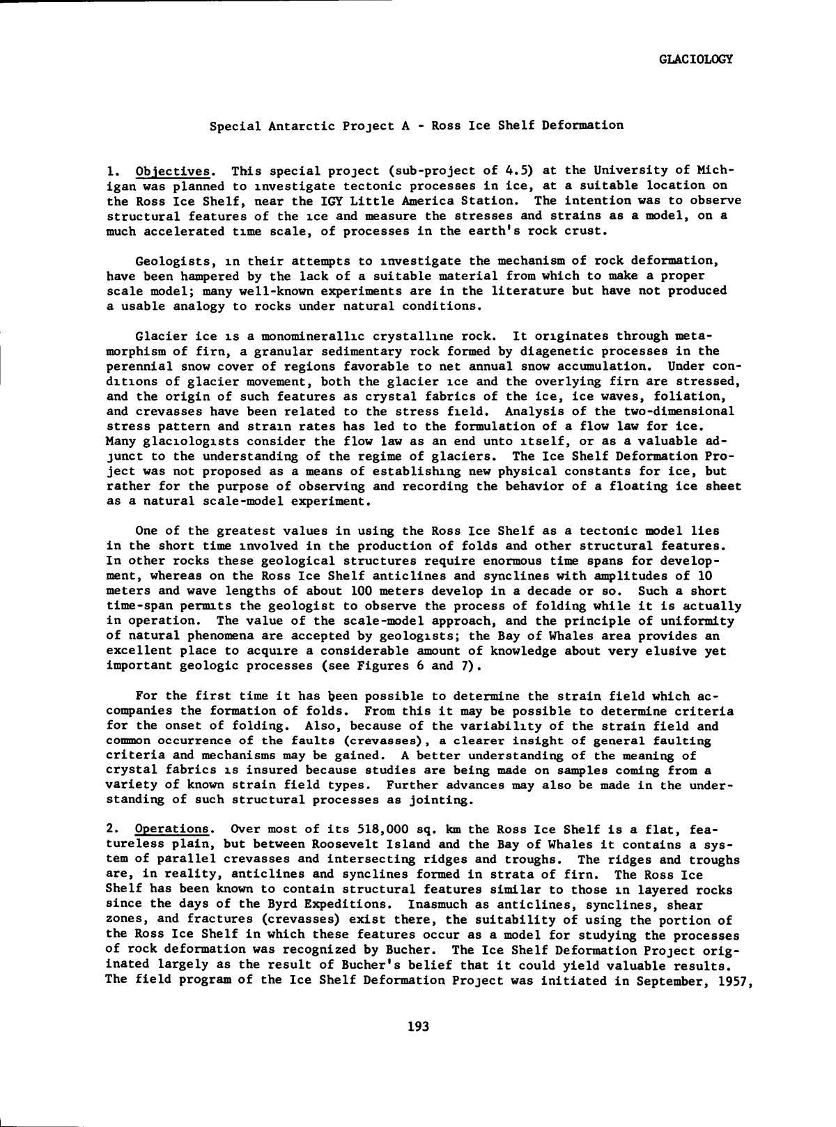
GLACIOLOGY closely spaced groups at regular intervals i n the cores. Thick bands of ice indica- tive of a period of pronounced thaw were not found and, i n the absence of such diag- nostic features, a detailed density analysis of successive layers i n the stratigraphic sequence was carried out. By this means, i t was possible to separate summer and win- ter snows and to determine the approximate annual accumulation, which was found to be about 15 cm water equivalent. Assuming an annual accumulation of 15 cm water equiva- lent, the ice at 309 meters i s estimated to be 2000 years old. Analyses of 0'^^/18^^ at 65, 114, 215, and 305 meters have not proved conclusive; the r e l a t i v e l y low accumu- lation and the d r i f t i n g snow factor are thought to be responsible for the d i f f i c u l t y i n integrating the oxygen isotope ratios. ( i ) Density. From the accurate determination of the depth-density p r o f i l e to the bottom of the d r i l l hole, three mechanisms of densification were ide n t i f i e d : (a) 0-10 m region. Sintering and packing of rounded polycrystalline grains were the primary mechanism. The rate of densification decreased exponentially from the surface to 10 m, where the density was 0.55 gm/cm'*. (b) 10-65 m region. The rate of densification was linear with depth; at 65 m the f i r n - i c e transition density of 0.83 gm/cmÌ was encountered. Pore-space elimination and ultimate development of equidimensional polycrystalline texture (for- mation of unicrystaller grains of polygonal outline) was the mechanism m t h i s region. (c) 65 m - bottom. Below 65 m, the rate of densification decreased ex- ponentially as a function of the compression of entrapped a i r bubbles. At 300 m, the bubble pressures were approximately 25 atmospheres. The mean cross-sectional area of crystals increased linearly with depth below 65 m. Detailed petrofabric studies revealed no patterns of preferred orientation at any depth. In December 1958, measurements were made i n the Byrd bore hole: ( i i ) Temperatures. The same temperature recording equipment was used i n the d r i l l hole at Byrd Station as was used at L i t t l e America. Tetiq>eratures were taken every 15.2 m to the 61 m level and then every 30.5 m to the 305 m level. Steel casing extends down the hole 35 m and has apparently influenced surrounding snow temperatures down to at least 46 m. No corrections have been made on the existing data, but pre- liminary examination indicates that temperatures are within 0.18''C of those recorded i n February 1958. Measurements on a t h i r d occasion show that the temperature has stabilized. ( i l l ) Hole Diameter. The diameter of the d r i l l hole was measured every 15.2 m by means of an electric caliper which varies a resistance as a function of the dia- meter. Resistance was measured with the same Wheatstone bridge and n u l l Indicator used for measuring temperatures. Closure of the hole i s shown by Figure 2. Measure- ments were repeated wherever points appeared to depart greatly from the mean curve. Total closure from the top 305 m of the casing was approximately 2.8 cm; the most re- cent observations show that the closure i s accelerating. (iv) Inclination. Thus far, no measurable in c l i n a t i o n has been observed. c. L i t t l e America. The f i r s t 4-inch diam. core was taken at a depth of 6.7 m and continuous core was obtained to a depth of 254.8 m with less than a 17, loss of the possible core. Although no saline ice was found i n the bottom core, proximity to the bottom of the shelf was evident when salt water seeped into the hole up to the 188.2 m level. Since no saline ice was found, i t i s possible that fresh ice continues to the ice-water interface which, from existing seismic information and temperature 167
GLACIOLOGY a. Ui o 0 40 80 120 160 200 240 280 3 20 360 400 440 480 520 560 600 640 680 720 760 800 840 880 920 960 Iâ 1000 3.0 40 Ueo HOLE CLOSURE BYRD STATION h HOLE DRILLED JAN 1958 80 \-\oo Ll20 â I â ' 7 0 " M E T E R S 20 D I A M E T E R (IN) 4.0 5.0 - r 8 0 9.0 lOO . ^ ^ 6.L. ^0 iTo ' 13 0 14Ì 0 ^^ISot h200 U220 h260 h280 C A S E D PORTION M JAN I960 D E C 1958 6 0 Figure 2. D r i l l hole closure with depth at Byrd Station. 168
GLACIOLOGY measurements, i s between 256 m and 259 m. This seems to indicate that the ice at the bottom i s melting rather than i n a stationary state or i n the process of forming new sea ice. ( i ) Stratigraphy. Detailed stratigraphic studies have been completed to a depth of 39 m. To f a c i l i t a t e glaciological studies i n the upper 3 - 4 m of snow and f i r n , three shallow pits were excavated some distance from the L i t t l e America V camp site. Detailed studies of the p i t walls were made i n order to supplement data from the mechanically d r i l l e d and hand-augered cores. As a result, a complete stratigraphic p r o f i l e , m addition to the depth-density p r o f i l e , was obtained for the Ross Ice Shelf i n the v i c i n i t y of L i t t l e America V. Summer snow deposits appeared as coarse-grained layers and frequently were associated with icy crusts, ice layers and glands. Winter deposits were finer - grained, more homogenous, and lacked the "soaked" appearance of summer accumulation. Periods of two or three consecutive years through the stratigraphic sequence showed intense ice formation. These periods appear to have occurred at more or less regular intervals which were approximately 10 to 12 years apart. Though ice crusts and ice lenses persist to greater depths, visual annual stratigraphic increments become ob- scure below 50 m. Layers of foreign material were observed at 172.1 m, 219.4 m, and 222.8 m. Microscopic examination of the f i r s t layer revealed aggregates of glassy, markedly angular material i d e n t i f i e d tentatively as volcanic ash. The second and t h i r d layers have not been examined microscopically but w i l l be studied i n d e t a i l at CRREL. ( i i ) Density Measurements. Approximately 500 density measurements were made in the f i e l d . Average length of core for density determination was 12 to 15 cm. Av- erage densities for meter increments show a steepening of the depth-density curve be- tween 20.7 and 36.5 m. The depth-density p r o f i l e was accurately determined to the bottom of the d r i l l hole. A density anomaly was found between 20 and 40 meters, which was i n agree- ment with stratigraphic data. There i s evidence to suggest that accumulation i n this region of anomalous density occurred at lower temperatures than now exist, or perhaps reflects some unique condition of the o r i g i n a l site of accumulation. To obtain some estimate of the annual precipitation of L i t t l e America V, several sections of ice core were d r i l l e d out by hand auger from beneath the floor of the glaciological laboratory and water equivalents calculated. These results are i n - tended to give only a general indication of the annual precipitation, but i t would ap- pear from the preliminary studies that- (a) 22 cm of water i s a f a i r average value, and (b) snow now 18 m below the surface was o r i g i n a l l y deposited on the Ross Ice Shelf about 40 years ago. Assuming that the ice shelf i n the v i c i n i t y of the d r i l l site i s composed entirely of depositional strata (melting at the bottom having eliminated the original basement of the shelf), and assuming a constant annual accumulation of 22 cm of water, then i t may be said that L i t t l e America V rests upon approximately 1225 years of accumulated snow. ( i l l ) Petrofabrics. Eight thin sections of the core from 62 m to 249 m have been examined on the Rigsby Universal Stage. Metamorphism of ice below the f i r n - i c e transition (55 meters at L i t t l e America V) proved to be more complex than at Byrd Station. Strained crystals were very much m evidence and strongly developed fabric orientations, observed below 90 meters, probably ref l e c t considerable deformation of the shelf ice. In the region 90 - 130 meters, a very marked Imeation of elongated bubbles was apparent. There was also evidence of dimensional orientation of crystals. Fabric patterns were observed to take the form of several closely grouped maxima of c-axes perpendicular to both the dimensional orientation of the crystals and bubble 169
GLACIOLOGY llneatlon. Below 140 meters, the ice showed an interlocked texture somewhat analagous to a three-dimensional jigsaw puzzle, the fabric pattern reduced to a single maximum of c-axes and the bubble lineations disappeared. (iv ) Future Investigations. I t i s hoped that the detailed examination of the deep cores from L i t t l e America V w i l l add considerably to knowledge of the structure, or i g i n , and glaciological history of the Ross Ice Shelf. Further research at CRREL w i l l include: (a) Estimation of annual accumulation from the stratigraphic record and study of variations i n the rate of accumulation inasmuch as they ref l e c t changes i n topographic and/or climatological conditions on the Ross Ice Shelf. (b) Grain size and crystal area studies (c) Petrofabric studies (d) Studies of bubble structure and bubble pressures (e) Entrapped gas analysis (f ) Particulate and salt analysis (g) Oxygen isotope analysis, etc. (v) Summary of Predominant Ice Occurrence i n Cores Depth (m) Ice Character Age of Ì Formation 5.07 - 5.55 Lenses and pellets 1947-48 9.85 - 10.05 Lenses and pellets 1935-36 **10.25 - 10.45 Thick lenses and pellets 1934-35 14.85 - 15.20 Chunky ice and lenses 1922-23 **16.10 - 16.40 Thick ice layer 1920-21 21.30 - 21.45 Chunky Ice and lenses 1908-09 25.35 - 25.40 Chunky ice and pellets 1895-96 **25.95 - 26.00 Pellets 1893-94 29.50 - 29.70 Chunky ice and pellets 1881-82 **30.50 - 30.65 Chunky ice and pellets 1879-80 40.25 - 40.35 Lenses 1846-47 **40.60 - 40.70 Ice gland (8 cm thick) 1845-46 46.65 - 49.00 Sporadic layer and pellets 1815-24 51.10 - 51.35 Lenses 1806-07 * The years have been reckoned on the assumption that the rate of accumulation has remained constant (22 cm water). The earlier dates (below 21.45 m) should be con- sidered approximate only. ** Consecutive years which show heavy melt. 170
GLACIOLOGY (vi) Deep D r i l l Hole Temperatures, L i t t l e America V. Temperature measurements were made i n the bottom of the deep d r i l l hole as i t was cored, and recorded to 0.001°C. A temperature probe containing four thermistors and a Leeds and Northrup platinum re- sistance thermometer, S/N 1063033 was used. The thermometer was calibrated by the Na- tional Bureau of Standards and used to calibrate the thermistors before and after measuring temperatures In the hole. The thermistor used was VECO No. 41A1 4-56. Re- sistance was measured with a Leeds and Northrup Cat. No. 9834 D.C. Null Detector. ( v i i ) Hole Diameter and Inclination. The diameter of the hole at L i t t l e America V was measured at the 91.5 m level. The mean of three measurements recorded was 5.759 cm. No attempt was made to make measurements of inclination. 6. Bibliography. a. Papers Presented at Meetings. H. Bader: "Deep D r i l l i n g i n Greenland." Xlth General Assembly lUGG, Sep- tember 1957, Toronto. J.A. Bender, A.J. Gow: "Deep D r i l l i n g I n Antarctica." X l l t h General Assembly lUGG, Helsinki, August 1960. b. Published Papers. R.W. Patenaude, E.W. Marshall, A. Gow: "Deep Core D r i l l i n g i n Ice, Byrd Station, Antarctica." SIPRE Technical Report 60, July 1959. R.H. Ragle, B.L. Hansen, A. Gow, R.W, Patenaude: "Deep Core D r i l l i n g i n the Ross Ice Shelf, L i t t l e America V, Antarctica." SIPRE Technical Report 70, June 1960. R.W. Patenaude: "Core D r i l l i n g i n Ice, Byrd Station, Antarctica, Part I : D r i l l i n g Techniques." IGY Glaciological Report Series No. 1. IGY World Data Center A-Glaciology, American Geographical Society, July 1958. E. Marshall, A. Gow: "Core D r i l l i n g i n Ice, Byrd Station, Antarctica, Part I I : Core Examination and D r i l l Hole Temperatures." IGY Glaciological Report Series No. 1. IGY World Data Center A-Glaciology, American Geo- graphical Society, July 1958. 171
GLACIOLOGY Project 4.8 - Antarctic Glaciological Equipment - Procurement 1. Objective. This project at the U.S. Army Cold Region Research and Engineering Laboratory (CRREL) was set up as an accommodation to the antarctic glaciological pro- gram. Through CRREL, special k i t s of glaciological equipment were procured and ship- ped to the antarctic stations. 2. Operations. Through many years of experimentation and f i e l d observations, stan- dard glaciological equipment (ice d r i l l s , augers, thermometers, snow samplers for den- si t y determination, rammsondes, etc.) were developed; these were made available as k i t s to the glaciologists planning programs i n Antarctica. I n addition, items of a more specialized nature were supplied, such as two petrographic microscopes with uni- versal stages, two large universal stages, and tubes for packing ice and snow cores. 3. Personnel. The procurement was under the supervision of Henri Bader. Project 4.9 - Glaciological Headquarters Office 1. Obiectives. This project, administered by the Arctic I n s t i t u t e of North America (AIM) provided for a small staff headquarters to plan the operational and s c i e n t i f i c aspects of the antarctic program, and parts of the arctic program. 2. Operations. The GHO provided the focal point for the detailed planning of the antarctic program. Station and t r a i l equipment were discussed with suppliers and other scientists who had experience i n i t s use. Requirements were developed for dis- cussion with Task Force 43 (US Navy) representatives for l o g i s t i c support for pre- season supplies and during-the-season resupply. Various university groups were con- tacted to develop interest i n supplying personnel and i n a few cases undertaking specialized antarctic research projects. The s c i e n t i f i c program was developed by the Glaciology Panel and carried out under the supervision of GHO. Much of the same ac- t i v i t y pertained also to the arctic program although i n that instance there were a l - ready m existence several research groups working i n the Arctic. Logistic support for remote arctic locations was planned and some work was also directed to the stan- dardization of data reporting for various types of observations. Finally, the pro- curement of supplies and equipment, spare parts, emergency parts, etc., was handled by GHO, personnel were i n large measure contacted and recruited by GHO. 3. Personnel. W.A. Wood, AINA, was the project director; GHO was staffed, u n t i l the beginning of f i e l d a c t i v i t i e s , by A.P. Crary (on leave from GRD) who was responsible for the antarctic planning and R.C. Hubley (Univ. of Washington) who was responsible for arctic planning; thereafter, Diane Fisher assumed responsibility for the opera- tion of the headquarters o f f i c e , maintaining communication with Crary and working closely with the Academy's IGY staff and the glaciology panel. 172
GLACIOLOGY Project 4.10 - Antarctic Data Reduction and Publication 1. Obiectives. This project at Ohio State University, provided for the reduction and limited publication of glaciological data and incidental geological observations gathered i n the Antarctic at station sites during 1957, 1958, and early 1959 as well as on oversnow traverses during the summers of 1957-58 and 1958-59. This would i n - clude the reduction and drawing of profiles for a l l traverse and station snow pi t s (temperature, density, ranmisonde, s t r a t i f i c a t i o n , hardness) and from station deep pit s (temperature, density, s t r a t i f i c a t i o n , hardness, and crystal structure). This included many hand cores. Special groups of shallow p i t s and sastrugi observations were studied. Some rammsonde figures and others were reduced i n the f i e l d ; a l l would be completed and presented by data and graph. Microclimatological data taken at certain selected stations have been reduced un- der the auspices of this project and reported where taken. Temperature profiles into the snow and ice, surface wind velocities, humidity, and water content of snow are included. In addition to the operations at Ohio State, four sub-projects were arranged for the reduction of data from three special studies: A. Ross Ice Shelf Deformation, University of Michigan, Dr. James H. Zumberge B. McMurdo Sound Glacial Geology, U.S. Geological Survey and University of Alaska, Dr. Troy L. PÌ wÌ C. L i t t l e America and South Pole Radiation Study, University of Innsbruck, Dr. Herfried Hoinkes D. Antarctic Biology, George Llano For details of these special projects, see end of this chapter. 2. Operations. a. Station and Traverse Glaciology. Ohio State University. F a c i l i t i e s were pro- vided at f i r s t by the Department of Geology and now at the OSU I n s t i t u t e of Polar Studies for the glaciologists returned from Antarctica. Here, the f i e l d logs and notes were used to prepare i n a systematized manner various glaciological data. A t o t a l of seventeen glaciologists worked at OSU preparing their data and notes for publication and submission to the IGY World Data Centers. A comprehensive report series was issued by the OSU project containing data tabulations, maps, and appro- priate text (see section 6. Bibliography). b. Special Projects. A. B. C. and D. Data reduction for these sub-projects was carried out at the respective i n s t i t u t i o n s and reports from B and C have been included i n the OSU series described above. 3. Personnel. This project was supervised by R.P. Goldthwait, OSU, with the aid of R.L. Cameron, a large number of scientists were responsible for carrying out the var- ious parts of the work (see Bibliography). 4. Data. A l l data have been processed and tabulated m form specified by the CSAGI or otherwise agreed upon, and were submitted to the data centers. 5. Results. I t i s not possible within the scope of this document to summarize sat- i s f a c t o r i l y a l l of the work covered by this project. The extensive bibliography (sec- tion 6) conveys an idea of the breadth of the s c i e n t i f i c work. 173
GLACIOLOGY Part X I I : J.M. Schopf, Paleobotanical Study of Rock Specimens from the Horlick Mountains ( i n preparation). Part X I I I : H. Hoinkes, Radiation Studies at L i t t l e America, 1957 ( i n preparation). R.L. Cameron, S.S. Goldich, and J.H. Hoffman: "Radioactivity Age of Rocks from the Windmill Islands, Buddcoast, Antarctica." Acta Universitatis Stockholmiensis. Stockholnx Contributions i n Geology, Vol. VI:1 (1160) 6 pp. H.A.C. Neuberg, et a l : "The Filchner Ice Shelf." Annals of the Assoc. of American Geographers. Vol. 49, No. 2, pp. 110-119, 1919. 176
GLACIOLOGY Project 4.11 - Glacier Photogrammetry and Mapping 1. Obiectives. This project at the American Geographical Society provided for the preparation of photogrammetric maps, on large scales, of selected small glaciers. The maps would form a permanent record of the condition of these glaciers so that at a future date they could be resurveyed and comparisons made. This procedure, i f car- ried over a sufficient time, would give the history of wastage and accumulation and the pattern of variation would provide the basis for more satisfactory and accurate interpretation of the response of these glaciers to meteorological and other factors. 2. Operations. Mr. W.O. Field of AGS made the i n i t i a l choice as a guide for glaciers to be mapped, the f i n a l decision being made i n the f i e l d . As a basis of selection, small valley glaciers from 5 to 8 kilometers i n length with simple unbranched systems were chosen. Another c r i t e r i o n was that the glaciers be widely separated and repre- sentative of different climatic environments. Furthermore, for l o g i s t i c a l reasons, i t was iiiq>ortant to choose insofar as possible glaciers i n proximity to roads, a i r - s t r i p s , and lakes suitable for landing a i r c r a f t . With these thoughts i n mind i t was hoped that maps could be completed of glaciers i n the following geographical locations; Central Chugach Mountains (Worthington Gla- c i e r ) , Central Alaska Range-Copper River Basin (West Gulkana Glacier), Northern Alaska Range-Yukon-Tanana Basin (Polychrome Glacier), Aleutian Islands (unspecified glacier), Kilbuck Mountain region-Kuskoquim Basin (Chukuminuk Glacier), Kenai Mountains (Bear Lake Glacier), Skolai Mountains (unspecified glacier), and the Coast Mountains on the southeastern coast (Lemon Creek Glacier); glaciers selected are indicated i n paren- theses i n preceding l i s t . Special e f f o r t s were made by the Air Photo Mission of the U.S. Coast and Geodetic Survey to obtain suitable mapping photography of a glacier i n the Aleutian Islands during the 1957 f i e l d season, but poor weather conditions prevented the accomplish- ment of this objective. Ground control was established on a glacier i n the Skolai Mountains and photography obtained, but owing to the unsatisfactory nature of the pho- tography, the preparation of an adequate map proved impossible. To the ori g i n a l group of locations was added one f i e l d site i n the St. Elias Mountains ( L i t t l e Jarvis Gla- c i e r ) . The McCall Glacier i n Alaska and the Blue Glacier, Olympic Mountains, Washing- ton, were added to complement other IGY projects. Very l i t t l e was known about most of the glaciers chosen for mapping, though most of them were roughly indicated on existing small-scale charts. The objective i n map- ping them was to obtain relative positions and elevations with maximum accuracy. On the other hand, the absolute orientation of the maps needed only to be approximate. The project was essentially a survey undertaking, rather than a glaciological inves- tiga t i o n , and was therefore organized and administered separately from the other work connected with glaciers being undertaken by the Society under Mr. Field's direction during the period of the IGY (Project 4.2). I t w i l l be observed that the mapping task differed to a considerable extent from that of an extensive topographical survey, and the f i e l d problem, apart from the techniques employed, was largely one of logistics. When the project was f i r s t proposed, I t was considered by some of those concerned with the planning that the glaciers should be mapped by the use of ground photogram- metry, already a well-established technique for this kind of mapping. However, for a number of reasons v e r t i c a l aerial photograph coverage i s desirable, provided i t can be obtained. Ground photogrammetry requires the handling of a great many photographs i n the pl o t t i n g Instrument. I t i s d i f f i c u l t i n rugged country to establish well- distributed and s u f f i c i e n t l y long ground-photogrammetric bases to obtain complete cov- erage of the terrain and to map i t with the required accuracy. Furthermore, i n gen- eral, v e r t i c a l aerial photographs are more revealing than ground photographs. I t was 177
GLACIOLOGY decided that every e f f o r t should be made to obtain the assistance of government agen- cies i n providing the required aerial photography. Thanks to the cooperation of the United States Navy and the United States Coast and Geodetic Survey, the Society was able to obtain the necessary coverage. The Society was assisted i n the negotiations with the Navy by the good services of Dr. Louis 0. Quam of the Office of Naval Research. Another serious problem i n the planning was the procedure to be adopted i n con- structing the maps from the photographs. As the Society did not have precise pl o t t i n g equipment, an academic i n s t i t u t i o n was sought that might consider the work i n the l i g h t of a research project. The Ohio State University, consulted on this matter, was fortunately i n a position to undertake the work. I t was agreed that the mapping task could be accomplished by a collaborative e f f o r t between the Society and the I n - s t i t u t e of Geodesy, Photogrammetry and Cartography. For this purpose, the Society established a fellowship at The Ohio State University, with the understanding that execution and analysis of the mapping would serve as the subject for a Master's thesis and a PhD dissertation for a graduate student i n the I n s t i t u t e . Under the supervision of Professor Frederick J. Doyle, the award of the fellowship was made to James G. Case. A Wild A-7 Autograph, a Kelsh plott e r , and other appropriate photogrammetric i n s t r u - ments were made available for his use. The Society agreed to assume over-all techni- cal supervision of the project and, specifically, (1) to select the glaciers to be mapped and to provide existing map and photographic coverage of the areas concerned, (2) to appoint the f i e l d party and provide a l l l o g i s t i c support for establishment of the required ground control; (3) to make arrangements for, and subsidize, a l l trans- portation and other travel expenses required for execution of the project; (4) to procure the aerial photography at no cost to the University, and (5) to cover the cost of processing the photography and furnish i t to the University i n a form suitable for the mapping work. a. The Organizational Problem. The American Geographical Society served as cen- t r a l control for the operation, with respect to both planning and administration. One of the primary l o g i s t i c problems was to arrange for the movement of a small f i e l d party (of three men) into a number of successive locations at considerable distances from one another, and to accomplish the work during the short season with the proba- b i l i t y of poor weather conditions. The Society obtained the services of Mr. Austin S. Post, who had had wide experience i n Alaska, for much of the l o g i s t i c a l planning. The success of the two years' operations was to a considerable extent made possible by his preliminary planning and by the close collaboration that he maintained with the Society during this period. Great credit i s also due Dr. Case who was i n charge of the technical surveys during the f i r s t year and continued doing this i n addition to assuming leadership i n the f i e l d i n 1958. Much of the pl o t t i n g of the maps was done by Dr. Case who also prepared a detailed analysis of the results as part of his doctoral dissertation. b. The Mapping Operations. Use was made of the Society's experience at Lemon Creek Glacier, i n planning the ground control for the aerial mapping. Many problems were encountered and eventually solved (for f u l l technical details see AGS Special Publication No. 34, and James B. Case, doctoral dissertation). Mapping i t s e l f was carried out at the Ohio State University. 3. Personnel. Dr. C.B. Hitchcock, AGS, was project director; James B. Case under- took the technical aspects of the project and Austin Post planned and led ( i n 1957) the f i e l d operations. Dr. Arthur J. Brandenburger and Prof. F.J. Doyle, Ohio State University, and Mr. O.M. Mi l l e r , technical advisor on photogrammetrical procedures; Mr. William Briesemeister and W.O. Field, AGS, were also associated with this project. 4. Data. A f u l l report and nine maps have been published by AGS and submitted to the IGY World Data Center. 178
GLACIOLOGY 5. Results. Considerable experience was obtained i n aerial photogrammetry that en- abled comparisons to be drawn with t e r r e s t r i a l photogrammetry. I t was concluded that i f a single glacier i s to be studied, t e r r e s t r i a l photogrammetry i s probably the most expedient method. On the other hand, where many glaciers are to be mapped, particu- l a r l y where the time at maximum ablation i s short, and i n remote areas where access i s not easy, and i f a i r c r a f t operate from bases near the f i e l d locations, aerial pho- togrammetry affords many advantages. I n addition, once ground control i s established, the glacier can be remapped i n the future from aerial work alone. 6. Bibliography. James B. Case: Masters Dissertation, Ohio State University, I n s t i t u t e of Geodesy, Photogrammetry, and Cartography. James B. Case: Doctoral Dissertation, Ohio State University, I n s t i t u t e of Geodesy, Photogrammetry, and Cartography. American Geographical Society: "Nine Glacier Maps, Northwestern North America." Am. Geog. Soc. Special Publication No. 34, New York, 1960. Austin S. Post: "The Exceptional Advances of the Muldrow, Black Rapids, and Susitna Glaciers." J ^ , vol. 65, no. 11, Nov., 1960. "Maps of Glacier Termini m Southern Alaska, F i r s t Series." American Geographic Society, New York, June 1965. 179
GLACIOLOGY Project 4.12 - Antarctic Ice Sampling, Isotope Ratios 1. Objectives. This project, at the California I n s t i t u t e of Technology, provided for the determination of ratios of 0I8/0I6 for samples collected i n the Antarctic as a means of determining the conditions under which precipitation occurred and as a pos- sible aid i n stratigraphy of deep cores. 2. Operations. Ice samples were collected at stations from various depths i n snow pit s and from pits dug during the summer traverses. Samples were also taken i n Green- land by SIPRE. 3. Personnel. R.P. Sharp was the project director, Samuel Epstein was responsible for the isotope measurements. 4. Data. Isotope information w i l l be supplied to origi n a l investigators for inc l u - sion i n their reports. Other information may be published i n the technical l i t e r a t u r e by personnel of this project. 5. Results. I n order to test various considerations pertinent to the use of oxygen- isotope relations i n glaciological research, systematically collected samples from the Greenland Ice Sheet were analyzed. I f the predicted relationships are borne out in this r e l a t i v e l y simple cold ice sheet, then i t becomes feasible to study some of the more complicated areas of the Antarctic and of some temperate glaciers. A series of f i r n samples was obtained from p i t s at depths of several meters at a number of l o c a l i t i e s i n Greenland. Samples of ice were also supplied from the deep bore hole at SIPRE's Site 2, specifically from depths of about 100 meters and about 300 meters. The data are reported i n terms of 8 values wherein 8 = ( 0I8/0I6 samples - 1 ) X 1000 0 /O mean ocean water The 8 expresses the OÌ /ÌOÌ ^ r a t i o relative to mean ocean wateg. ^Since 5 = 0 i s the value for mean ocean water, a l l negative Ì values indicate 0^ /O ratios lower, pos- i t i v e & values represent 0 / 0 ratios higher than mean ocean water. The following figures and table summarize some of the results for the Greenland Ice Sheet and some early results for South Pole samples. Figure 3 shows the seasonal variation i n OÌ /ÌOÌ ^ ra t i o of snow with depth for two collection sites i n northern Greenland, 360 km apart at about 2440 meters and 3060 meters elevation. The summer snows have the highest & values and the winter snows have the lowest (more negative) 8 values. I n some cases the variations are as much as 200 times the precision of measurement. The differences i n amplitude i n OÌ /ÌO rat i o variation i n Figure 1 are worth noting. I n spite of the great distance sepa- rating the two sites, there i s surprisingly good correlation of the amplitudes for the same year of accumulation. I n addition, the summer and winter layers of accumu- lation have been ide n t i f i e d independently by glaciological evidence prior to the iso- tope study. Figures 4 and 5 show the seasonal variations at about 100 and 300 meters depth at SIPRE Site 2 m Greenland. Even at these depths where most of the grain characteris- t i c s have been obliterated, the seasonal variations i n the 0^°/0^° r a t i o are s t i l l preserved. Thus, i t i s possible to use isotope data, where other c r i t e r i a may f a i l , to determine rates of accumulation for ice at least 800 years old. 180
â¢24r GLACIOLOGY â¢30-r - 40 - - 4 8 - S -22H 10,000 ft -30- - 4 0 - -461 8,000 ft 0 50 100 150 200 250 DEPTH cm 300 Figure 3. The Seasonal Variation i n OÌ /ÌOÌ ^ Ratio of Snow with Depth for Two Sites i n Northern Greenland, 360 km Apart. Zero depth represents snow surface of June, 1955. 350 400 181
GLACIOLOGY -24^ â¢26^ -28 8 â¢32 - 34 n 1 1 r. 1 ( 1 n I ^ ' \ 1 i 1 r-' ^ ' \ -» ' 1 1 ; , 1 , 1 ^ 1 ' , ' 1 ⢠/ ' ^ ' ! ' " s ; 1 1 ⢠1 ' ' 1 1 1 1 rJ 1 , 1 u i f -' ' " u I ; ⢠K ⢠1 1 ' In l l " 1 ' 1 1 '' 1 ⢠11 . ' ' ⢠J 1 , " !_/ S 1 / f \ ' » ' d â 1 1 1 9740 60 80 9800 20 .40 60 80 9900 20 40 DEPTH IN METERS Figure 4. Seasonal Variation at about 100 m Depth SIPRE Site 2, Greenland - 34 296 60 80 29700 20 40 DEPTH IN METERS Figure 5. Seasonal Variation at about 300 m Depth SIPRE Site 2, Greenland. 182 60
GLACIOLOGY The Greenland analyses demonstrate the v a l i d i t y of certain basic relations i n the isotope r a t i o of ice and snow which can now be applied to the Antarctic. Table 1 shows some of the data for the South Pole station. Unfortunately, not enough samples were collected from a single accumulation layer to determine the regularity of sea- sonal variation. On the other hand large variations i n the S values exist, and the regularity and amplitude of this variation can be tested by further samplings. I t i s of interest that the 0 / 0 ratios m the South Pole samples are the lowest > ured, confirming nicely the basic premise on temperature control. yet meas- TABLE I Snow and Firn Samples from South Pole Station Depth (cm) SP -⢠101 Shallow Pit #2 40-45 -52.35 SP ⢠⢠102 I f I I M 80-85 -52.82 SP ⢠⢠103 I I 11 I I 115-120 -52.37 SP ⢠⢠104 I I I I I t 140-145 -45.90 SP -⢠30 Main Pit 195-200 -49.89 SP - 29 I f I I 245-250 -46.50 SP ⢠- 28 I I I I 280-285 -47.29 SP ⢠⢠27 I f t i 275-280 -46.87 SP ⢠- 26 f t f i 320-325 -44.42 SP ⢠25 f i I f 345-350 -47.51 SP - 24 I I I I 382-387 -50.86 SP - 23 M I I 420-425 -47.64 SP - 22 I I t l 465-470 -48.43 SP - 21 I I I I 510-515 -49.89 SP 5 I f f l 855-860 -50.82 SP - 15 I I I I 1265-1270 -47.70 SP - 9 Deep Pit #1 1071-1076 -47.70 183
GLACIOLOGY Project 4,17 - McCall Glacier, Brooks Range 1. Objectives. This project, conducted by the Arctic I n s t i t u t e of North America, provided for the study of the McCall Glacier i n the eastern Brooks Range of northern Alaska. The f i e l d program which lasted 16 months (with a 3 month interruption) i n - cluded a) a glacial-meteorological program with objectives: ( i ) to measure the net exchange of mass and thermal energy between the glacier and i t s meteorological envir- onment, ( i i ) to determine the contribution of each of the meteorological processes of mass and energy transfer to the net mass and energy transfer between glacier and en- vironment, ( i l l ) to make a theoretical analysis of the relationships between fluctua- tions i n t o t a l mass and thermal energy of the glacier and fluctuations i n the regional climate for both seasonal and climatic variations; b) accumulation-ablation studies of the glacier's lower extent to determine net ablation or accumulation during the summer season and to determine the mechanism of accumulation; c) snow p i t studies m the gla- cier's highest cirque to determine ( i ) net exchange of mass and energy between glacier and atmosphere i n the accumulation region and ( i i ) to determine the v e r t i c a l d i s t r i - bution and transfer of mass and energy within the f i r n , and d) photograometric and ice motion studies to establish the dynamic role of mass transfer by glacier flow i n the glacier's mass balance. 2. Operations. With air drops supplied by the U.S. Air Force, Ladd Air Force Base, Fairbanks, Alaska, and commercial l i g h t plane transport the f i e l d party occupied the glacier i n May 1957. The unfortunate death of the s c i e n t i f i c leader m October ended the f i r s t year's a c t i v i t y . The station was reoccupied i n February 1958. The main camp and observation site were located near the head of the glacier's highest cirque at an elevation of 2300 meters. The micrometeorological program, syn- optic weather observations, and the snow study program were conducted from this sta- tion. A lower camp was established on a la t e r a l moraine of the valley tongue (1650 m) about five km from the main camp and two-and-one-half km up-glacier from the terminus. Surface motion studies and ablation measurements were carried out during the summer from this camp. a. Surface Motion Studies (1957). The ice motion surveys on the McCall Glacier were established i n order to find the character of movement m the surface ice and to help i n the determination of the mass budget. Standard triangulation methods were used to determine the magnitude of the ice motion. Four lat e r a l profiles of nine stakes each and a set of five stakes i n the ter- minus were positioned i n May and June and surveyed from that time through October. An independent baseline at each p r o f i l e was set up to take stereo photos and accomplish the survey. The length of each base was chosen to be the photogrammetric optimum with respect to the length of the p r o f i l e . This 1:10 ra t i o meant that most of the bases were on the order of forty meters, a length which also allowed the majority of stakes to f a l l within the l i m i t i n g ratios of 1:4 and 1:20. The baseline for one set was an exception to t h i s , i t s size being determined by the snow cover at the time of the i n - i t i a l survey with the result that a ten-meter base was used. Once the snow l e f t i t was thought better to maintain continuity of photography so no change was made. Some d i f f i c u l t y was encountered i n establishing the bases because of the lack of stable rock to use for stations. The major portion of the valley i s either coarse moraine or the rubble-stream flanks of the ridges. I n both cases the bedrock i s too well covered to use for stations and such outcrops as do occur are not found i n l i k e l y spots for control points. The stations were therefore marked on large boulders of the l a t e r a l moraine as i t was f e l t that creep would not be too great here. The surveys were made with the theodolite incorporated m a Wild T-30 Phototheodolite. I t was observed early i n the summer that varying weather conditions could af- fect the reading of an angle by as much as ten sexagecimal seconds. Refraction of 184
GIACIOLOCT t h i s magnitude was not thought to be frequent, but i t was weighed heavily i n deciding the o v e r a l l accuracy assumed i n the r e s u l t s . A l l angles were read twice d i r e c t and twice reverse to a tolerance of ten seconds. During the e a r l i e r p o r t i o n of the summer three r e p e t i t i o n s of each angle were turned, making twelve readings to each stake, but l a t e r t h i s was abandoned m favor of one r e p e t i t i o n . While t h i s increases the oppor- t u n i t y f o r mechanical e r r o r s , l i k e misreading an angle, the progress had been slowed to such a degree by heavy p r . e c i p i t a t i o n and fog that the program was f a l l i n g behind schedule. The use of greater care appears to have obviated any such gross e r r o r s , however, and the surveys were accomplished more r a p i d l y . P r e - f i e l d planning had not envisaged the magnitude of the melting on the lower portions of the g l a c i e r . This meant th a t the f o u r - f o o t motion stakes required r e - s e t t i n g , usually when work was going on at the upper end of the g l a c i e r . Consequently, a few stakes near the terminus f e l l out and t h e i r p o s i t i o n and motion l o s t f o r that period. b. A b l a t i o n Studies. Detailed studies on the a b l a t i o n of the lower McCall Glacier were c a r r i e d out from June 23 to September 1, 1957. Some p e r t i n e n t data had been gath- ered p r i o r to the e a r l i e r date and some were obtained i n October. A b l a t i o n and accu- mulation on the lower McCall Glacier was determined by measuring changes i n surface l e v e l , and, i n the case of snow, changes i n density. McCall Glacier ice i s here as- sumed to have a density of 0.9 which i s constant w i t h respect to time and l o c a t i o n . At the intermediate camp two wooden dowels, 2.54 cm i n diameter and 1.2 meters i n length, were set i n the i c e , one on the crest of the g l a c i e r and one on the east side very near the moraine. Measurements of height of stake above the surface, depth of snow, and density of snow were made d a i l y . Both stakes were p e r i o d i c a l l y reset as surface lowering exceeded by several times the depth of the stakes i n the i c e . D r i l l - ing f o r emplacement of the stakes was done w i t h a CRREL (formerly SIPRE) ice auger. Height of stake above the snow and depth of snow were measured at the movement p r o f i l e stakes each time the p r o f i l e s were surveyed or roughly once every three weeks. The stakes used f o r movement studies were i d e n t i c a l to those at the intermediate camp. Some stake records at the p r o f i l e s were discarded as the stakes had melted out com- p l e t e l y between observations. The number of stakes at each p r o f i l e insured complete coverage of a l l conditions of slope and snow depth on the lower g l a c i e r . Mass f i g u r e s of a b l a t i o n were determined by m u l t i p l y i n g change i n surface l e v e l by the density of the melting substance, whether snow or i c e . The formation of super- imposed ice was determined by probing. The depth to the f i r s t hard surface encountered was subtracted from the known depth of the o r i g i n a l surface to give the thickness of the superimposed i c e . Snow depth and density of snow i s required to compute the depth to the o r i g i n a l surface. Not a l l i n d i v i d u a l stake measurements covered the same time spans; ther e f o r e , to determine t o t a l summer loss i t was necessary to set up a r a t i o of the loss at any one stake to the loss over the same period at the intermediate camp stakes. This r a t i o was used to compute t o t a l a b l a t i o n by m u l t i p l y i n g i t times the f i g u r e f o r a b l a t i o n at the intermediate camp f o r the period June 23 to September 1. I n order to do t h i s i t must be assumed that rates of a b l a t i o n at the p r o f i l e stakes were constantly i n the same propo r t i o n to those at the intermediate camp stakes. 3. Personnel. W.A. Wood, AINA, was adm i n i s t r a t i v e p r o j e c t d i r e c t o r , R.C. Hubley was Chief S c i e n t i s t ( u n t i l October 1957) and Svenn Orvig was Chief S c i e n t i s t t h e r e a f t e r . 4. Data. Data and reports have been submitted to World Data Center-A. 5. Results. The period June 23 to September 1, 1957 was estimated to be roughly co- incident w i t h the summer a b l a t i o n season f o r that year. Melting at the lowest p r o f i l e between May 21 and June 23 was s l i g h t and almost c e r t a i n l y nonexistent p r i o r to May. 185
GLACIOLOGY Shortly a f t e r evacuation of the intermediate camp on September 3 , a heavy snowfall covered the g l a c i e r and ended the a b l a t i o n season. A b l a t i o n may occur during the win- t e r through the mechanism of wind d e f l a t i o n , however, t h i s would only remove snow f a l - l i n g during the f a l l and winter. The lower McCall Glacier was snow-free throughout most o f the summer, thus surface lowering was due to the melting of g l a c i e r i c e . As no g l a c i e r i n the Brooks Range had been studied previous to t h i s p r o j e c t , and as few meteorological records were a v a i l a b l e , there had been no way to p r e d i c t the rate of melt which might be expected. A b l a t i o n values were s u r p r i s i n g l y high, i n f a c t , not a great deal less than those recorded on the Blue Glacier, Olympic Mountains, Washington, which i s very d e f i n i t e l y a temperate g l a c i e r . Dr. Hubley thought, however, th a t the 1957 a b l a t i o n season was a p a r t i c u l a r l y long and warm one. The stake which served as a reference point f o r surface change measurements was located on the crest of the g l a c i e r near the intermediate camp. The slope o f the g l a - c i e r at t h i s point was 11?, d i r e c t l y down-glacier. Daily measurements were also car- r i e d out at another stake 70 m away on the edge of the g l a c i e r where the slope was 237o at r i g h t angles to the general trend of the g l a c i e r . Surface lowering was only a few m i l l i m e t e r s higher per day at t h i s stake. a. Snow Cover. The snow cover present on June 23 was the r e s u l t of l a t e May and ea r l y June storms. I n l a t e A p r i l when the g l a c i e r was f i r s t occupied the snow cover was very t h i n and i n some places non-existent. The snow cover i n July and August was present only a f t e r a storm and then disappeared very r a p i d l y . Because of the ra p i d removal no changes i n c r y s t a l s t r u c t u r e of the snow were noted. I n only a few i s o l a t e d places on the lower g l a c i e r d i d snow remain a l l summer. These were avalanche d r i f t s located along the west w a l l of the g l a c i e r . I t may be said that without doubt the metamorphism of snow i n t o f i r n does not c o n s t i t u t e a means of acciunulation of the lower g l a c i e r . I n f a c t , w i t h the possible exception of a few i s o l a t e d small patches, f i r n i c a t i o n does not occur at a l l . I t seems possible that the lower g l a c i e r i s nearly snow-free throughout most of the winter due to high winds and l i t t l e p r e c i p i t a t i o n . This was observed to be the case during l a t e October, b. Superimposed Ice. Superimposed ice was observed to form a f t e r storms under a snow cover and was followed by melting of the snow. Melt water p e r c o l a t i n g through the snow cover probably freezes on contact w i t h the g l a c i e r ice surface which i s kept cool through the i n s u l a t i o n provided by the snow cover. Very l i t t l e ice forms during the summer because of the r e l a t i v e l y warm temperature of the surface i c e . I n l a t e October a trench 20 cm deep was cut i n the ice near the crest of the g l a c i e r . The observed s t r a t i g r a p h y was as follows: 4 cm of new snow w i t h small i n - d i v i d u a l star-shaped c r y s t a l s 2 mm i n diameter, 1-3 cm of greyish porous ice which flaked away from the lower ice surface when struck. Below t h i s layer was a white dense i c e . The porous i c e i s believed to be superimposed i c e . I t was t h i c k e s t i n the micro- r e l i e f v a l l e y s where there would have been the greatest accumulation of water. This ice was undoubtedly formed at the very end of the a b l a t i o n season. Several times during the summer when the nighttime a i r temperatures had dropped below freezing a s i m i l a r formation was noted on the g l a c i e r . I t was very smooth i n contrast to the normally rough surfaoe and impaired walking. Superimposed i c e forms i n large quan- t i t i e s only i n two places on the g l a c i e r where small lakes e x i s t during the summer. As both lakes are i n areas where there i s snow throughout the summer, they are prob- ably preserved from year to year w i t h each summer's lake forming on top of the previous summers. c. Meteorological Data. The synoptic observations f o r the complete period of oc- cupation have been tabulated, and published (see b i b l i o g r a p h y ) . I n a d d i t i o n , a l l micrometeorological data have been successfully reduced from the o r i g i n a l recorder data to meteorological values by the use of e l e c t r o n i c computer and machine t a b u l a t i o n s , 186
GLACIOLOGY Approximately 200 pages o£ tabulated data (wind speed and temperatures) at d i f f e r e n t l e v e l s . A l l elements of the r a d i a t i o n balance are included i n t h i s p u b l i c a t i o n of meteorological data. 6. Bibliography. J.E. Sater: "Surface Motion Studies "of the McCall Glacier, June to October 1957," and CM. Keeler: "Ablation Studies: Lower McCall Glacier, June 23 to Sept. 1, 1957." IGY G l a c i o l o g i c a l Report Series. No. 1, July 1958, IGY World Data Center A-Glaciology, American Geographical Society, New York J.E. Sater: "Glacier Studies of the McCall Glacier." A r c t i c , v o l . 12, no. 2, June 1959, pp. 82-86. R.W. Mason: "The McCall Glacier Project and I t s L o g i s t i c s . " A r c t i c , v o l . 12, no. 2, June 1959, pp. 77-81. CM. Keeler: "Notes on the Geology of the McCall Valley Area." A r c t i c , v o l . 12, no. 2, June 1959, pp. 87-97. R.W. Mason: "The McCall Glacier S t a t i o n , Brooks Range, Alaska." American Alpine Journal, v o l . 12, No. 1, 1960, pp 79-86. S. Orvig: "McCall Glacier, Alaska, Meteorological Observations 1957-1958." AINA Research Paper No. 8, 1961, 166 pp. 187
GLACIOLOGY Project 4.18 - A r c t i c Sea Ice Physics 1. Objectives. The a r c t i c i c e f l o e g l a c i o l o g i c a l p r o j e c t , Department of Meteorology and Climatology, U n i v e r s i t y of Washington, was mainly concerned w i t h the problem of the heat budget of the A r c t i c Ocean: to determine and analyze the r a t e of growth or shrinkage of the pack i c e ; the s t r a t i g r a p h y and p e t r o f a b r i c s of the pack i c e ; and the r e l a t i o n s h i p of growth or shrinkage, s t r a t i g r a p h y and c r y s t a l l o g r a p h i c c h a r a c t e r i s t i c s of the pack to thermodynamics of the i c e , as w e l l as t h e i r r e l a t i o n s h i p to mass and energy exchange between the pack i c e and i t s meteorological and oceanographic environ- ments. The p a r t i c u l a r items were measurements of solar r a d i a t i o n , albedo of snow and ice surface at regular i n t e r v a l s throughout the year, measurements of wind gradients above the ice surface, study of a b l a t i o n and accumulation of the snow and ice at the surface, v a r i a t i o n s i n pack ice thickness, measurements of temperatures above and i n the pack i c e , and the study of age of the ice at d i f f e r e n t depths by s t r a t i g r a p h i c means and by c r y s t a l o r i e n t a t i o n studies. This p r o j e c t provided f o r part of the salary expenses of the senior i n v e s t i g a t o r and f o r g l a c i o l o g i c a l equipment. The remainder of the support came from p r o j e c t 9.19 (under chapter X-Oceanography). For a l l f u r t h e r d e t a i l s see p r o j e c t 9.19. 188
GLACIOLOGY Project 4.20 - A n t a r c t i c G l a c i a l Geology 1. Objectives. This p r o j e c t at the A r c t i c I n s t i t u t e of North America provided f o r support of geological personnel t o v i s i t A n t a r c t i c a during the summer season and ex- plore i c e - f r e e regions. G l a c i a l geology i s a branch of geomorphology dealing w i t h the c o n f i g u r a t i o n of the surface, and the changes i n land forms that have taken place i n areas once covered w i t h g l a c i e r i c e . I t i s therefore a study of past g l a c i a l h i s - t o r y . I n A n t a r c t i c a , ice free areas were to be studied w i t h p a r t i c u l a r a t t e n t i o n d i - rected to g l a c i a l v a l l e y s , moraines, raised beaches, g l a c i a l s i l t , cirque erosion, e r r a t i c s , ice p o l i s h i n g , s t r i a t i o n s and f r o s t a c t i o n . (See also unnumbered p r o j e c t B, at end of t h i s chapter, f o r other geological work supported under 4.5 and 4.10). 2. Operations. A small group operated out of McMurdo Sound, concentrating t h e i r e f - f o r t s at Marble Point, October 1958 through January 1959. The studies at Marble Point included: a. the r a t e of movement of the Wilson Piedmont Glacier ( i ) by an analysis of the bending of the sea ice i n f r o n t of the b a r r i e r of the g l a c i e r ( i i ) by analysis of t h r u s t planes on the b a r r i e r ( i i i ) by t r i a n g u l a t i o n b. snow d r i f t i c e slabs - size, s t r a t i g r a p h y , d i s t r i b u t i o n and o r i e n t a t i o n c. thickness and c h a r a c t e r i s t i c s of l a c u s t r i n e ice of Taylor Dry Valley d. c h a r a c t e r i s t i c s of the ice f r o n t e. winter wind d i r e c t i o n ( i ) v e n t i f a c t s ( i i ) d i s t r i b u t i o n of snow d r i f t ice slabs ( i l l ) d i s t r i b u t i o n of snow shadows ( i v ) d i s t r i b u t i o n of snow barchans (v) d i s t r i b u t i o n of granule and pebble dunes ( v i ) d i s t r i b u t i o n of granule and pebble veneers f. Caliche formation i n the active zone g. permafrost and a c t i v e zone h. dunes (granule and pebble) - mechanical analyses 1. raised beaches ( i ) c o l l e c t e d bones of elephant seal from a beach approximately 44 feet above sea l e v e l , C-14 date would date beach and give r a t e of u p l i f t ( i i ) studies of p i t t e d raised beaches which bull-dozing and digging showed to be r e s t i n g on an ice foot which has persisted during an u p l i f t of 45-55 feet J. s o l i f l u c t i o n (incomplete, snow cover i n t e r f e r e d ) - slopes, lobes, sheets, c l i f f l e t s , processes k. kame terraces, kame h i l l o c k s , v a l l e y t r a i n s , felsenmeers 1. elevated wave-washed surfaces and marine boulder pavements 3. Personnel. W.A. Wood, AINA, was a d m i n i s t r a t i v e p r o j e c t d i r e c t o r . Dr. R.L. Nichols, Tufts U n i v e r s i t y , c a r r i e d out the geological i n v e s t i g a t i o n s . 4. Data. Reports have been submitted to the IGY World Data Center. 5. Results. I n a preliminary report on the i n v e s t i g a t i o n s at McMurdo Sound, the i n - v e s t i g a t o r reported on several aspects of coastal geomorphology at McMurdo Sound. 189
GLACIOLOGY We11-developed elevated beaches, wave-washed bedrock surfaces, and marine-boulder pavements are found from New Harbor north to Granite Harbor. The highest measured elevated beach on Dunlop I s l a n d was 20.4 meters above sea l e v e l . The marine l i m i t at Marble Point i s 20.1 m above sea l e v e l , at Cape Roberts, ap- proximately 48 km to the north, i t i s also 20.1 m above sea l e v e l . The marine l i m i t therefore does not t i l t between these two po i n t s . A radiocarbon measurement of an elephant seal, buried i n an elevated beach about 13.4 m above sea l e v e l at Marble Point, i n d i c a t e s that t h i s beach i s 4600 ^ 200 years o l d . Some elevated beaches terminate more or less perpendicularly against the Wilson Piedmont Glacier. I t i s not known whether a l l of these beaches extend beneath the g l a c i e r and i n d i c a t e a g l a c i a l re-advance, or whether a period of beach-building a- gainst the g l a c i e r was followed by a long g l a c i a l s t i l l s t a n d . The beaches were de- r i v e d mainly from t i l l and outwash and have been buried l o c a l l y by s o l i f l u c t i o n , e o l i a n , outwash, and landslide deposits and by t a l u s . An extensive elevated beach found at Marble. Point i s between 13.7 and 16.8 m above sea l e v e l . The beach gravels are i n places only 38 to 51 cm t h i c k , and they r e s t on clean ice which, m one place, i s more than 2.1 m t h i c k . This ice i s e i t h e r an e l e - vated ice foot or a stagnant mass of g l a c i a l i c e . This beach and the ice which i t buries are more than 4600 ± 200 years o l d , as they are above the beach i n which the buried elephant seal was found. Numerous round, oblong, and i r r e g u l a r l y shaped p i t s and hollows are found on many of the beaches. They range m diameter from less than 4.5 m to more than 12 m, and most are less than 1.2 m deep. These beaches were deposited on i c e , and the p i t s and hollows were formed by the d i f f e r e n t i a l melting of t h i s i c e . During the f u l l - b o d i e d stage of g l a c i a t i o n , the Wilson Piedmont Glacier terminated m deep water. I t seems l i k e l y that the oldest beaches were formed close to the place where the g l a c i e r , during i t s r e t r e a t , f i r s t uncovered land. With continued r e t r e a t and c r u s t a l u p l i f t consequent on d e g l a c i a t i o n , younger and lower beaches were formed. The f i r s t beaches were formed at the terminus of the g l a c i e r , and younger and younger beaches were formed at increasing distances from i t . Several features i n d i c a t e that the f i r s t beaches were formed close to the g l a c i e r . The highest beaches i n many places are p i t t e d . P i t s are not found i n general on the lower beaches. This suggests that the p i t s were formed by the melting of fragments of ice which f e l l from the g l a c i e r onto the beaches and were buried by beach gravels. A gap approximately 30 m long i s found i n the highest beach ridge near Marble Point. I t seems l i k e l y that the gap r e - sulted from the erosional a c t i v i t y of a meltwater stream which came from the g l a c i e r when I t was close to the beach. The highest beach i n the southern part of the main- land near Spike Cape i s abruptly truncated on the south. The presence of the Wilson Piedmont Glacier i n the area where the highest beach i s not now found when t h i s beach was being formed elsewhere, followed by g l a c i a l r e t r e a t i s responsible f o r the t r u n - c a t i o n . The absence of the highest beach ridge on a kame ridge near the mouth of the "Surko River" indicates the presence of ice i n t h i s area when the highest beach was being formed elsewhere. The presence of p i t s on some of the highest beach ridges, of a meter or so of ice beneath beaches 13-17 m above sea l e v e l , of a buried elephant seal i n an elevated beach 13.4 m above sea l e v e l , and of gravel ridges on s l i g h t l y elevated beaches de- posited by stranded gravel-veneered pieces of ice which broke o f f from an ice foot i n d i c a t e that a l l the beaches were formed i n climates l i k e that now found i n the McMurdo Sound area. 190
GLACIOLOGY 6. Bibliography. a. Published Papers. R.L. Nichols: "Coastal Geomorphology, McMurdo Sound, A n t a r c t i c a : Prelim- in a r y Report." IGY Glaciology Report No. 4. pp. 51-101, Jan. 1961, AGS, New York. R.L. Nichols: " C h a r a c t e r i s t i c s of Beaches Formed i n Polar Climates." o£. c l t . , pp. 103-121. R.L. Nichols: " C h a r a c t e r i s t i c s of Beaches Formed i n Polar Climates." Am. Journ. Science ( i n press) 191
GLACIOLOGY Project 4.21 - A r c t i c L o g i s t i c s 1. Objectives. This p r o j e c t at the A r c t i c I n s t i t u t e of North America (AINA) pro- vided f o r the purchase of f i e l d equipment and supplies f o r use i n connection w i t h the Blue Glacier and McCall Glacier p r o j e c t s (4.1, 4.3 and 4.17) and g l a c i e r observation and photogranmetry i n Alaska (4.2, 4,11). 2. Operations. Tents (both frame-type and l i g h t w e i g h t ) , sleeping bags and a i r mat- tresses, f i e l d r a t i o n s , heaters, generators, f u e l , cable, radfo sets, and b a t t e r i e s , were purchased f o r the various p r o j e c t s . 3. Personnel. W.A. Wood was p r o j e c t d i r e c t o r . 192
GLACIOLOGY Special A n t a r c t i c Project A - Ross Ice Shelf Deformation 1. Objectives. This special p r o j e c t (sub-project of 4.5) at the U n i v e r s i t y of Mich- igan was planned to i n v e s t i g a t e t e c t o n i c processes i n i c e , at a s u i t a b l e l o c a t i o n on the Ross Ice Shelf, near the IGY L i t t l e America S t a t i o n . The i n t e n t i o n was to observe s t r u c t u r a l features of the ice and measure the stresses and s t r a i n s as a model, on a much accelerated time scale, of processes i n the earth's rock c r u s t . Geologists, i n t h e i r attempts to i n v e s t i g a t e the mechanism of rock defoinnation, have been hampered by the lack of a s u i t a b l e m a t e r i a l from which t o make a proper scale model; many well-known experiments are i n the l i t e r a t u r e but have not produced a usable analogy to rocks under n a t u r a l conditions. Glacier i ce i s a monominerallic c r y s t a l l i n e rock. I t o r i g i n a t e s through meta- morphism of f i r n , a granular sedimentary rock formed by diagenetic processes i n the perennial snow cover of regions favorable t o net annual snow accumulation. Under con- d i t i o n s of g l a c i e r movement, both the g l a c i e r i c e and the o v e r l y i n g f i r n are stressed, and the o r i g i n of such features as c r y s t a l f a b r i c s of the i c e , ice waves, f o l i a t i o n , and crevasses have been r e l a t e d to the stress f i e l d . Analysis of the two-dimensional stress p a t t e r n and s t r a i n rates has led to the formulation of a flow law f o r i c e . Many g l a c i o l o g i s t s consider the flow law as an end unto i t s e l f , or as a valuable ad- j u n c t to the understanding of the regime of g l a c i e r s . The Ice Shelf Deformation Pro- j e c t was not proposed as a means of e s t a b l i s h i n g new physical constants f o r i c e , but rather f o r the purpose of observing and recording the behavior of a f l o a t i n g i c e sheet as a n a t u r a l scale-model experiment. One of the greatest values i n using the Ross Ice Shelf as a t e c t o n i c model l i e s i n the short time involved i n the production of f o l d s and other s t r u c t u r a l features. I n other rocks these g e o l o g i c a l s t r u c t u r e s require enormous time spans f o r develop- ment, whereas on the Ross Ice Shelf a n t i c l i n e s and synclines w i t h amplitudes of 10 meters and wave lengths of about 100 meters develop i n a decade or so. Such a short time-span permits the geologist to observe the process of f o l d i n g while i t i s a c t u a l l y i n operation. The value of the scale-model approach, and the p r i n c i p l e of u n i f o r m i t y of n a t u r a l phenomena are accepted by geologists; the Bay of Whales area provides an excellent place to acquire a considerable amount of knowledge about very elusive yet important geologic processes (see Figures 6 and 7). For the f i r s t time i t has been possible to determine the s t r a i n f i e l d which ac- companies the formation of f o l d s . From t h i s i t may be possible to determine c r i t e r i a f o r the onset of f o l d i n g . Also, because of the v a r i a b i l i t y of the s t r a i n f i e l d and common occurrence of the f a u l t s (crevasses), a clearer i n s i g h t of general f a u l t i n g c r i t e r i a and mechanisms may be gained. A b e t t e r understanding of the meaning of c r y s t a l f a b r i c s i s insured because studies are being made on samples coming from a v a r i e t y of known s t r a i n f i e l d types. Further advances may also be made i n the under- standing of such s t r u c t u r a l processes as j o i n t i n g . 2. Operations. Over most of i t s 518,000 sq. km the Ross Ice Shelf i s a f l a t , fea- tureless p l a i n , but between Roosevelt I s l a n d and the Bay of Whales i t contains a sys- tem of p a r a l l e l crevasses and i n t e r s e c t i n g ridges and troughs. The ridges and troughs are, i n r e a l i t y , a n t i c l i n e s and synclines formed i n s t r a t a of f i r n . The Ross Ice Shelf has been known to contain s t r u c t u r a l features s i m i l a r to those i n layered rocks since the days of the Byrd Expeditions. Inasmuch as a n t i c l i n e s , synclines, shear zones, and f r a c t u r e s (crevasses) e x i s t there, the s u i t a b i l i t y of using the p o r t i o n of the Ross Ice Shelf i n which these features occur as a model f o r studying the processes of rock deformation was recognized by Bucher. The Ice Shelf Deformation Project o r i g - inated l a r g e l y as the r e s u l t of Bucher's b e l i e f that i t could y i e l d valuable r e s u l t s . The f i e l d program of the Ice Shelf Deformation Project was i n i t i a t e d i n September, 1957, 193
GLACIOLOGY I66«» 165" I64» I63<» 162* 161* I60*> Edge of Barrier Ice 1957 Little America 1,1 Little America V -Ì>| Little America III Camp Mict)igan 442 ROOSEVELT I ISLAND \ 377 ..«-|-(Spot elevations in meters) 640 MAP OF PART OF THE ROSS ICE SHELF SHOWING LOCATION OF DEFORMATION AREA AND VARIOUS U S A SCIENTIF IC B A S E S Based on Ctiart No 16384-10, US Navy Hydrographic Office,Ed July, 1958. 166* I65<» 164* 163* 162® I6I< 160* Figure 6. 194
GLACIOLOGY « M U 5 HQ,, pnotognipn flean in DM«mb«r i997 If oiMtulOliOfi Neitmotr W JofM't I9U MAP OF THE STRUCTURAL F E A T U R E S OF THE ROSS ICE SHELF NEAR CAMP MICHIGAN NOVEMBER-DECEMBER 1957 J A M E S M Z U M B E R G E eXPUNATlON I I Sm c* ot vorymg rhiciincti â C r t v o t i e Anticlinal out Moior rrior*9ulOlion irotion A A(30) mm ereiorioni n metert obovf wo level > 3 meteri Comp Michigon A 0(24) A FI30} Srran<l/ aitturb4d c t contain* Biaar erMt* antf grauart rUt»$ 3(24) A S H E L F I C E â¢ZOO MOO Figure 7. 195
GLACIOLOGY and ended i n January, 1959. The base of operations was Camp Michigan, which, i n December of 1957, was located at 163°57.3'W, 78°34.0'S. a. 1957-58 F i e l d Season. The f i r s t season's work was devoted mainly t o p r e l i m - i n a r y i n v e s t i g a t i o n s of the area, w i t h a concentrated e f f o r t toward the establishment of a t r i a n g u l a t i o n network and base l i n e f o r remeasurement i n f u t u r e years so that the gross deformation r a t e could be determined. Topographic mapping of selected fea- tures to determine t h e i r general d i s t r i b u t i o n and special r e l a t i o n s h i p s was also given high p r i o r i t y during the f i r s t f i e l d season. The general mapping program was g r e a t l y enhanced and accelerated by the use of a e r i a l photographs taken from an a l t i t u d e of 5,000 feet w i t h a 6-inch camera i n January, 1958. Snow p i t s were dug, and the d e t a i l s of snow s t r a t i g r a p h y were studied and recorded. Temperature measurements were made d a i l y at various depths, and accumulation stakes were set out i n s t r a t e g i c areas. A few s t r a i n gauges were i n s t a l l e d i n crevasses and read every day, or as the schedule o f a c t i v i t i e s permitted. The camp was evacuated on January 7, 1958, and l e f t unoccu- pied during the a n t a r c t i c w i n t e r . b. 1958-59 F i e l d Season. Camp Michigan was reoccupied by a second f i e l d p a rty i n November 1958, f o r the purpose of continuing the deformation studies. The main e f f o r t s of the second team were centered around the determination of s t r a i n rates i n selected areas, f u r t h e r s t r a t i g r a p h i c studies, and p e t r o f a b r i c analyses of deformed ice layers. Two deep cores, 3 inches i n diameter, were hand-augered and transported to the U n i v e r s i t y of Michigan, where they were studied i n d e t a i l . 3. Personnel. James H. Zumberge was the p r i n c i p a l i n v e s t i g a t o r , p r i n c i p a l personnel associated w i t h him were Mario Gi o v i n e t t o , Ralph Kehle, John Reid, Nolan Aughenbaugh and James Burnham. 4. Data. A d e t a i l e d report on t h i s p r o j e c t was submitted to the IGY World Data Cen- ter-A, Glaciology. 5. Results. The Ross Ice Shelf, between Roosevelt I s l a n d and the Bay of Whales, con- t a i n s two c h a r a c t e r i s t i c features: systems of p a r a l l e l crevasses and the a n t i c l i n a l and s y n c l i n a l ridges. a. P a r a l l e l Crevasse Systems. The crevasses generally trend i n an east-west d i - r e c t i o n , and range i n w i d t h from less than a h a l f meter to more than 8 meters. Some crevasses extend f o r a distance of 1 km but many are less than h a l f t h i s distance, and most of the crevasses are a few hundred meters long. The depths of the few cre- vasses measured ranged from 19 to 25 meters. However, most of these soundings do not r e f l e c t the r e a l depths, since most of the crevasses contained collapsed snow bridges at the bottom. The most s t r i k i n g feature of the crevasses i s t h e i r marked p a r a l l e l i s m and regular spacing. This phenomenon by i t s e l f argues f o r some uniform stress p a t t e r n i n the she l f , and i t was t h i s i n t r i g u i n g s i t u a t i o n t h a t made the area such a valuable study s i t e . b. A n t i c l i n e s and Synclines. The n^v^-ice a n t i c l i n e s , or f i r n f o l d s , are roughly p a r a l l e l and trend i n a north-south d i r e c t i o n . The a n t i c l i n e s are more pronounced, topographically, than the synclines, because the l a t t e r are traps f o r d r i f t i n g snow and, therefore, tend to be subdued i n surface expression as soon as they are formed. The f o l d s have amplitudes of 5 to 15 meters w i t h wave lengths of 100 meters or more. The s i m i l a r i t y of these s t r u c t u r a l features of the Ross Ice Shelf to folded sedimen- t a r y rocks i s immediately apparent. Furthermore, the f a c t t h a t the axes o f most, but not a l l , of the fol d s are orthogonal to the crevasse systems i s s t i l l another argument i n favor of a systematic stress p a t t e r n i n the area. The a n t i c l i n e whose axis s t r i k e s n o r t h from t r i a n g u l a t i o n s t a t i o n B was studied and instrumented m considerable d e t a i l as part of the deformation i n v e s t i g a t i o n s . 196
GLACIOLOGY c. Thickness. Seismic soundings i n the deformation area were made by Cook and Crary on separate occasions. Both Cook and Crary used t r i a n g u l a t i o n s t a t i o n A as a seismic s t a t i o n . Cook reports 131 meters of ice shelf at t h i s p o i n t , and Crary reports 133 meters. At a p o i n t on the baseline 800 meters toward B from A ( F i g . 7) Crary gives an i c e shelf thickness of 70-80 meters. Other r e l i a b l e values, measured by Cook, are as f o l l o w s : near t r i a n g u l a t i o n s t a t i o n Q, 113 meters, near t r i a n g u l a t i o n s t a t i o n B (west end of b a s e l i n e ) , 131 meters; near t r i a n g u l a t i o n s t a t i o n D ( c r e s t of a n t i c l i n e ) , 125 meters. The seismic data are not s u f f i c i e n t to permit the c o n s t r u c t i o n of a de- t a i l e d isopach map of ice thickness f o r the deformation area, but, i n general, the r e - gion of the Ross Ice Shelf n o r t h of Aoosevelt I s l a n d i s two to three times thinner than shelf i c e east or west of the deformation area, and i t i s the r e l a t i v e l y t h i n i c e between Roosevelt I s l a n d and the Bay of Whales that i s e a s i l y deformed i n t o f o l d s be- tween the t h i c k e r i c e on e i t h e r side which flows around the i s l a n d . d. Depth of Water. The Ross Ice Shelf i s a f l o a t from the northern edge of Roose- v e l t I s l a n d t o the seaward edge of the s h e l f . Cook reports a depth of 567 meters at s t a t i o n A (Camp Michigan), and Crary reports 565 meters f o r the same place. Nowhere i n the e n t i r e deformation area i s the i c e grounded. The strong deformation i n the Camp Michigan area i s therefore not produced by any drag or f r i c t i o n on the bottom, but r a t h e r by a h o r i z o n t a l stress system i n the shelf r e s u l t i n g from northward flow around the east and west sides of Roosevelt I s l a n d . Unfortunately, no r e l i a b l e t h i c k - ness measurements were obtained at an a n t i c l i n a l crest and at the trough of an adja- cent syncline. I t i s , t h e r e f o r e , not possible to state whether the ice thickens as i t f o l d s , although from t h e o r e t i c a l considerations alone, i t would seem th a t the ice shelf thickness measured v e r t i c a l l y through the crest of an a n t i c l i n e should be greater than the i c e thickness measured through the trough of an adjacent syncline. More theo- r e t i c a l work on t h i s subject would be p r o f i t a b l e i n terms of the mechanics of f o l d i n g . e. Density. Density determinations were made i n the w a l l s of snow p i t s , crevasse w a l l s , and hand-augered cores. Density determinations at the a n t i c l i n a l crest and ad- jacent s y n c l i n a l trough near s t a t i o n D show a markedly higher density at corresponding depths when compared to those from crevasse Alpha. The increased density i n the folded ice may be the n a t u r a l consequence of the compressional h o r i z o n t a l stresses which pro- duced the f o l d i n g . I f t h i s i s t r u e , then the general statement that the density of a cold g l a c i e r ( i . e . , no summer melting) i s a f u n c t i o n of depth does not hold true f o r the part of the Ross Ice Shelf undergoing l a t e r a l coiiq>ression. Some of the p l a s t i c deformation induced by the h o r i z o n t a l stress i s apparently taken up i n the Increased density of the f l r n . A comparison of d e n s i t i e s from various cold g l a c i e r s shows th a t the values f o r the f o l d near t r i a n g u l a t i o n s t a t i o n D on the Ross Shelf are the highest f o r the 5, 10, and 15 meter depths. Another f a c t o r t h a t undoubtedly accounts f o r some of the i n - crease i n density of the folded f i r n i s compaction by wind on the crest of the a n t i - c l i n e . Density values i n the upper meter of the a n t i c l i n a l crest are generally higher than the upper meter of the adjacent trough. But, the f a c t that the density values f o r both crest and trough are generally higher than those at comparable depths i n non- folded areas argues i n favor of the increased d e n s i f I c a t i o n by l a t e r a l compression. f . J i m Stratigraphy. Giovinetto's snow p i t studies i n d i c a t e the average net an- nuat aceumulation f o r the non-disturbed area i n the v i c i n i t y of Camp Michigan to be 20.0 cm of water. His analysis of the f i r n s t r a t i g r a p h y i n the folded area Indicates a minimum age of 33 years f o r the s t r u c t u r e as of 1958. The basis f o r t h i s conclusion i s r e l a t e d to the f a c t t h a t , i n 1957-58, the crest of the a n t i c l i n e i n question r e - ceived less accumulation than the trough of the adjacent syncline, but that sometime i n the past, before the crest stood s i g n i f i c a n t l y higher than the surrounding snow surface, there was no s i g n i f i c a n t d i f f e r e n c e i n the accumulation between crest and 197
GLACIOLOGY trough. S t r a t i g r a p h i c studies show that the year 1926 marked the beginning of a trend i n which the crest received less accumulation because of i t s increased height above the surrounding surface. g. S t r a i n Rates. Kehle's data on s t r a i n rates involve base l i n e measurements and a t r i a n g u l a t i o n network of the gross deformation area, rectangular g r i d systems of stakes placed m selected locations which contained deformation features such as crevasses or fo l d s i n varying degrees of development; surface s t r a i n r o s e t t e s ; peg rosettes on crevasse w a l l s ; and d i r e c t measurement of the ra t e of crevasse opening. I n general, Kehle shows th a t f o l d axes are almost always perpendicular to the p r i n c i - pal compressive axis, but tha t crevasses are e s s e n t i a l l y perpendicular to the p r i n c i - pal tension axis except i n the immediate v i c i n i t y of the a n t i c l i n a l c r e s t s where the crevasses make a considerable angle w i t h respect to the p r i n c i p a l axes of stress. Kehle's s t r a i n rates f o r ice i n crevassed and non-crevassed areas define a rupture c r i t e r i a f o r ice which, mathematically, takes the form of a surface of r e v o l u t i o n around the l i n e sj^ - S2. I n an independent evaluation of the age of the major study a n t i c l i n e , Kehle a r r i v e s at a f i g u r e of 20-30 years based on rough measurement of a n t i c l i n a l growth. h. Petrofabrics of a Folded Ice Layer. Reid describes a moderately strong pre- fe r r e d c r y s t a l o r i e n t a t i o n f o r a t h i n ice layer interbedded w i t h f i r n . The maximum concentration of the c-axes i s 8 to 97. per one per cent of the area. Fabric diagrams p l o t t e d on a Schmidt equal-area net generally show four maxima 12° to 17° from the equator, and i n c l i n e d 20° from one of the planes of p r i n c i p a l shear but e s s e n t i a l l y normal to the other shear plane. The c r y s t a l f a b r i c of a small ptygmatic f o l d on one limb of the a n t i c l i n e suggests to Reid that the whole ice layer i s deforming by d i f - f e r e n t i a l s l i p along the basal plane which i s almost p a r a l l e l to the a x i a l plane of the a n t i c l i n e . 6. Bibliography. a. Papers Presented at Meetings. James H. Zumberge: "Preliminary Report on the Ross Ice Shelf Deformation P r o j e c t . " Synqjosium Chamonix, 16-24 Sept. 1958, pp. 56-63 (Pub. 47, De D'Association I n t e r n a t i o n a l e D'Hydrologie S c i e n t i f i q u e . ) James H. Zumberge: "Geologic Structures of the Ross Ice Shelf, A n t a r c t i c a . " I n t . Geol. Congress, XXL Session. (Pub. i n Part 21, pp. 60-67, 1960.) Ralph Kehle: "Deformation of the Ross Ice Shelf, Camp Michigan, Bay of Whales Region, A n t a r c t i c a . " Ann. Meeting, Geolog. Soc. Am., Pi t t s b u r g h 1959. ( B u l l . Geol. Soc. America, v. 70, p. 1629, 1959.) John R. Reid: "Petrofabric Studies of an Ice Layer from a F i r n Fold Near the Bay of Whales, A n t a r c t i c a . " Ann. Meeting Geolog. Soc. Amer., Denver, 1960. J.H. Zumberge: "Ross Ice Shelf G l a c i o l o g i c a l Studies." X l l t h Gen. Assemb. lUGG, August 1961, H e l s i n k i . b. Published Papers. J.H. Zumberge, M. Giov i n e t t o , R. Kehle, J. Reid: "Deformation of the Ross Ice Shelf Near the Bay of Whales, A n t a r c t i c a . " IGY G l a c i o l o g i c a l Report Series. No. 3, IGY World Data Center A-Glaciology, American Geographical Society, New York, May 1960. Ralph 0. Kehle: "Deformation of the Ross Ice Shelf, A n t a r c t i c a . " Geol. Soc. America B u l l . , v. 75, pp. 259-286, A p r i l 1964. John R. Reid: "£|tructural Glaciology of an Ice Layer i n a F i r n Fold, Ross Ice Shelf, A n t a r c t i c a : Ice Grain Analysis." Jour, of Glaciology. v. 5, no. 38, pp. 191-205, June 1964. 198
GLACIOLOGY Special A n t a r c t i c Project B - G l a c i a l Geology i n the McMurdo Sound Area 1. Objectives. This special p r o j e c t (sub-project of 4.5 and 4.10) of Dr. Troy L. Vivi (U.S. Geological Survey and U n i v e r s i t y of Alaska) was undertaken as part of the o v e r - a l l o b j e c t i v e to determine the past and present status of a n t a r c t i c g l a c i a t i o n . Through i n t e r p r e t a t i o n of geological evidence i t o f t e n proves possible to deduce the chronology of past g l a c i a l a c t i v i t y . The i c e - f r e e areas i n the v i c i n i t y of McMurdo Sound were v i s i t e d and evidence and data c o l l e c t e d f o r study. 2. Operations. The f i e l d work of t h i s p r o j e c t was accomplished i n December 1957 through February 1958, based from McMurdo Sound, A n t a r c t i c a . U.S. Navy h e l i c o p t e r f a c i l i t i e s made possible the establishment and re-supply of camps i n Taylor Dry Valley and other g l a c i e r free locations on the east, west and south sides of McMurdo Sound. The geol o g i c a l party camped out i n the area and examined the many geological features. U.S. Navy a e r i a l photography of the region was obtained as a d d i t i o n a l information. Some plant l i f e was c o l l e c t e d f o r study and mummified remains of seals were c o l l e c t e d f o r C-14 dating. Many samples of unconsolidated sediments were taken as w e l l as many bedrock samples f o r examination m laboratory and o f f i c e a f t e r r e t u r n i n g to the United States. Also samples of water and ice as w e l l as samples of m i r a b i l i t e and gypsum were c o l l e c t e d f o r chemical analyses. 3. Personnel. Troy L. PÌ wÌ was p r i n c i p a l i n v e s t i g a t o r , assisted by N.R. Rivard. 4. Data. A number of papers and reports were published and supplied to IGY World Data Center A, Glaciology. 5. Results. a. M u l t i p l e G l a c i a t i o n i n A n t a r c t i c a . The land on the west side of McMurdo Sound may c o n s t i t u t e the largest i c e - f r e e area of A n t a r c t i c a ( F i g . 8 ) . This area i s 10 to 50 miles wide and at least 100 miles long, consisting of a l t e r n a t i n g eastward-trending ridges and v a l l e y s w i t h an average r e l i e f of 3,000 to 6,000 feet and a t o t a l r e l i e f of 13,000 f e e t . The c o n t i n e n t a l ice cap has withdrawn from the region, but a few large o u t l e t g l a c i e r s and a multitude of small alpine g l a c i e r s s t i l l e x i s t . The area w i t h i n 20 to 30 miles of the sea i s composed of metamorphic rocks w i t h g r a n i t i c i n - t r u s i o n s . The o u t l e t g l a c i e r s emanate from the ice cap and d r a i n through passes toward the sea, the small alpine g l a c i e r s o r i g i n a t e i n the mountains and are independent of the ice cap. The g l a c i e r s are polar g l a c i e r s and no water issues from underneath or w i t h i n them; however, during December and January, some meltwater runs from the sur- face of the lower ends of the g l a c i e r s , forming t r a n s i e n t shallow streams. Some of these streams extend to the sea but most of them d r a i n i n t o landlocked lakes. ( i ) Climate. The climate of the McMurdo Sound region i s rigorous, character- ized by low temperatures (mostly below f r e e z i n g ) , a r i d i t y (annual r a i n f a l l 2-6 inches), and wind. ( i i ) G l a c i a l Chronology. At least four Quaternary g l a c i a t i o n s (a g l a c i a l ad- vance and r e t r e a t represented by deposits and landforms t h a t can be distinguished from other g l a c i a l deposits of d i f f e r e n t ages) are recorded i n .the i c e - f r e e v a l l e y s on the west side of McMurdo Sound and around the islands and mountains p r o j e c t i n g above the o u t l e t g l a c i e r s . The youngest advance l e f t d r i f t t hat i s s t i l l cored w i t h g l a c i a l i c e ; the two next older advances are marked by subdued moraines; deposits of the o l d - est recognized g l a c i a t i o n , however, are scanty and only preserved on high ridges. 199
GLACIOLOGY McMurdo Sound Mt Discover/ Eiilling gloclari I T O * _ I Figure 8. Sketch map (by T.L. Pewe, 1959)of McMurdo Sound, A n t a r c t i c a , showing extent o f e x i s t i n g g l a c i e r s . L e t t e r symbols on map: B, Beaufort I s l a n d ; WP, Wilson Piedmont Glacier; CR Cape Royds; E,Mount Erebus; KM, K u k r i H i l l s ; S, Stranded Moraines; DI,Dailey Islands; NAF, Williams Naval A i r F a c i l i t y ; H, Hobbs Gl a c i e r ; D, Davis Glacier; G, Garwood Glacier; M, Mlers Glacier. (Base modified a f t e r U.S. Navy Hydro- graphic O f f i c e Chart No. 6636 [Ross Sea], 3rd ed., September 23, 1957.) 9 0 H l l M MpMurdo Sound Taylor Dry Islond Broan Island While Island ^lock Island Discovery V'j Eiilting gloclsfl extent of Inferred McMurdo Glociotion Figure 9. Sketch map (by T.L. Pewe, 1959) of McMurdo Sound, A n t a r c t i c a , showing extent of e x i s t i n g g l a c i a l i c e and i n f e r r e d extent of McMurdo G l a c i a t i o n . L e t t e r symbols on map: B, Beaufort I s l a n d ; WF, Wilson Piedmont Glacier; CR, Cape Royds; E,Mount Erebus; KH, K u k r i H i l l s ; S, Stranded Moraines; D I , Dalley Islands; NAF, Williams Naval A i r F a c i l i t y ; H, Hobbs Glacier; D, Davis G l a c i e r ; G, Garwood G l a c i e r , M, Mlers Glacier. (Base modified a f t e r U.S. Navy Hydro- graphic O f f i c e Chart No. 6636 [Ross Sea], 3d ed., September 23, 1957.) 200
GIACIOLOGY (a) McMurdo G l a c i a t i o n . The e a r l i e s t and most extensive g l a c i a l advance recognized has been named the McMurdo G l a c i a t i o n ( F i g . 9 ) . Patches of d r i f t of t h i s g l a c i a t i o n occur on,ridges 2,000 feet above sea l e v e l on the west side of K o e t t l i t z Glacier, and m Taylor Dry Valley about 3,000 feet above sea l e v e l , 2,500 feet above the f l o o r of the v a l l e y , near the top of Mount Nussbaum. Great a n t i q u i t y of the McMurdo G l a c i a t i o n deposits i s ind i c a t e d by the lack of morainal form and the boulders and cobbles planed l e v e l w i t h the ground surface by wind abrasion. During McMurdo G l a c i a t i o n , Taylor Glacier, dr a i n i n g the expanded ice cap, f i l l e d Taylor Dry Valley to an e l e v a t i o n probably higher than 3,000 feet and co- alesced w i t h the expanded K o e t t l i t z Glacier i n McMurdo Sound, as d i d the Ferrar Gla- c i e r . K o e t t l i t z Outlet Glacier rose to at least 2,000 feet above sea l e v e l on the west side of the K o e t t l i t z Valley. I t also coalesced w i t h the Ross Ice Shelf and i t i s conjectured, by p r o j e c t i n g o l d ice-surface p r o f i l e s , that the ice completely cov- ered Brown I s l a n d , 2,300 fe e t high, and Black I s l a n d , 3,500 feet high. Also, i f Mount Discovery (probably i n part a Pleistocene volcanic cone) were near i t s present height, the i c e surrounded the mountain up to an e l e v a t i o n of approximately 5,000 f e e t . The ice of the McMurdo g l a c i a t i o n must have extended to 2,000 feet above sea l e v e l on the flanks of ancestral Mount Erebus. (b) Taylor G l a c i a t i o n . The next recognized g l a c i a l advance i n the McMurdo Region, the Taylor G l a c i a t i o n ( F i g . 10) has l e f t on the f l o o r and lower slopes of Taylor Dry Valley widespread deposits more extensively preserved than those of the McMurdo G l a c i a t i o n . The Taylor Glacier f i l l e d Taylor Dry Valley w i t h ice to an el e - v a t i o n of approximately 1,000 feet above sea l e v e l . Ice d i d not cover Mount Nussbaum as I t d i d i n the McMurdo advance. Ferrar Glacier pushed out i n t o the Sound as the ice cap expanded. Strong ice push from the K o e t t l i t z Glacier to the south e v i d e n t l y caused the Ferrar Glacier to wrap around the base of the Kukri H i l l s , merge w i t h Tay- l o r Glacier, and push up t o 1,000 to 1,200 feet above sea l e v e l around H j o r t h H i l l and Hogback H i l l . This ice coalesced w i t h the Wilson Piedmont Glacier. K o e t t l i t z Glacier expanded and bulged l a t e r a l l y 4 to 5 miles up the empty eastward trending v a l l e y s on i t s west side. (c) F r y x e l l G l a c i a t i o n . The next recognized g l a c i a l advance, the Fry- x e l l G l a c i a t i o n ( Fig. 11), i s named a f t e r well-preserved moraines adjacent to Lake F r y x e l l i n lower Taylor Dry Valley, between Canada and Commonwealth Glaciers. This g l a c i a t i o n was less extensive than the Taylor G l a c i a t i o n , the K o e t t l i t z Outlet Gla- c i e r being less extensive and bulging 2 to 3 miles up the i c e - f r e e v a l l e y s on the west. That the F r y x e l l G l a c i a t i o n i s o l d i s i n d i c a t e d by the w e l l devel- oped desert pavement on the d r i f t and the w e l l developed v e n t i f a c t s . Also, g u l l i e s and canyons have been cut through the d r i f t by small streams that e x i s t only a few days a year. A series of raised marine beaches, the highest about 66 feet above sea l e v e l , occur i n f r o n t of Wilson Piedmont Glacier. They formed since the Wilson Pied- mont Glacier withdrew from the area at the close of the F r y x e l l G l a c i a t i o n . This phenomenon may also be used as a crude measure of the age of the F r y x e l l G l a c i a t i o n because i t must have taken considerable time f o r u p l i f t , and formation of the beaches i n a Sound which was frozen most of the year. (d) K o e t t l i t z G l a c i a t i o n . The l a t e s t major g l a c i a t i o n i n the region i s the K o e t t l i t z G l a c i a t i o n ( F i g . 12), named a f t e r the exceedingly w e l l preserved moraines on both sides of the K o e t t l i t z Glacier. This g l a c i a l advance was the least extensive of the major advances and only the o u t l e t g l a c i e r s have l e f t widespread deposits, which are w e l l preserved and d i s t i n c t ; they are e a s i l y d i f f e r e n t i a t e d from the older g l a c i a l d r i f t because the moraines of the K o e t t l i t z G l a c i a t i o n are s t i l l f i l l e d w i t h stagnant g l a c i a l i c e . 201
GIACIOLOGY McMurdo Sound Taylor Dry Vol slond oc I e Brown Island While Islond Block Island t . Eiillinj glocierl / I 1 Inferred extern o( Taylor GlQCiQiron / B 0 I70» â1 Figure 10a. Sketch map (by T.L. Pewe) of McMurdo Sound, A n t a r c t i c a , showing extent of e x i s t i n g g l a c i a l i c e and i n - f e r r e d extent of Taylor G l a c l a t l o n . L e t t e r symbols on map: B, Beaufort I s l a n d ; WF, Wilson Piedmont Glacier; E, Mount Erebus; KH, K u k r i H i l l s ; S, Stranded Moraines; D I , Dalley Islands; NAF, Williams Naval A i r F a c i l i t y ; H, Hobbs Glacier; D, Davis Glacier; G, Garwood Glacier; M, Mlers Glacier. (Base modified a f t e r U.S. Navy Hydro- graphic O f f i c e Chart No. 6636 [Ross Sea] 3d ed., September 23, 1957.) Wilson Piedmont Glocier B M i l e i Contour intervol 1000 Feet Doshod lines represent liolf.interval contours . . j E«isling glociers [, ] Inferred extent of Toylor Glociatlon Commonweolth Glacier Conodo Glacier McMurdo Sound Frysell Suess Glocier LocroK Glacier Nussboum Bonney Taylor Glacier Figure 10b. Sketch map of Taylor Dry V a l l e y , Antarc- t i c a , showing extent of e x i s t i n g g l a c i a l i c e and i n f e r r e d extent o f Taylor G l a c l a t l o n . L e t t e r symbols on map: HH, Hogback H i l l } H, H j o r t h H i l l ; R, Rhone Glacier; S, Sollas Glacier; M, Marr Glacier. (Base modi- f i e d a f t e r map of Ferrar- K o e t t l l t z D i s t r i c t , B r i t i s h A n t a r c t i c Expedition 1910- 1913 "Terra Nova.") 202
GIACIOLOGY Wilson Piedmont Glocier B M i i e i Contour intervol 1000 Feet Doshod tines represent tioir.Interval contours V j Existing glociers Inferred extent of Fryxell Glociotion Commonwealth Glacier McMurdo Sound Canada Glociar Fryxell Suess Glocier Locroix Glacier Nussboum Bonney Toylor Glacier Figure 11. Sketch map (by T.L. Pewe, 1959) of Taylor Dry Valley,Ant- a r c t i c a , showing extent of e x i s t i n g g l a c i a l i c e and i n f e r r e d extent of F r y x e l l G l a c i a t i o n . Let- t e r symbols on map: HH, Hogback H i l l ; H, H j o r t h H i l l ; R, Rhone Glacier; Sollas Glacier; M, Marr Glacier. (Base modified a f t e r map of F e r r a r - K o e t t l i t z Dis- t r i c t , B r i t i s h Antarc- t i c Expedition 1910-13 "Terra Nova".) T I60» â I â 170* McMurdo Sound Toylor Brown scovery t " VJ Eiitling gloclart W:M Interred extent of KoeMlti Gloclotlon ^ / Figure 12. Sketch map (by T.L. Pewe,1959) of McMurdo Sound,Antarctica,showing extent of e x i s t i n g g l a c i a l i c e and i n f e r r e d ex- t e n t o f K o e t t l l t z G l a c i a t i o n . L e t t e r sym- bols on map: B, Beaufort I s l a n d , WP, W i l - son Piedmont Glacier; CR, Cape Royds; E, Mount Erebus; KH, Ku k r i H i l l s ; S, Stranded Moraines; DI, Dailey Islands; NAF,Williams Naval A i r F a c i l i t y ; H, Hobbs Glacier; D, Davis Glacier; G, Garwood Glacier; M,Miers Glacier. (Base modified a f t e r U.S. Navy Hydrographic O f f i c e Chart No. 6636 [Ross Sea], 3d ed., September 23, 1957.) 203
During K o e t t l i t z G l a c i a t i o n the alpine g l a c i e r s that poured i n t o the desert v a l l e y s were only a few hundreds of yards more extensive than they are now. The o u t l e t g l a c i e r s and shelf ice were much more extensive. The K o e t t l i t z Glacier pushed 1 to 2 miles up the dry v a l l e y s on the west side of the K o e t t l i t z Glacier Val- ley. The K o e t t l i t z Glacier was also much t h i c k e r and flanked Mount Discovery at an e l e v a t i o n of 1,700 f e e t above sea l e v e l . The i c e almost covered Brown I s l a n d as i t pushed up to 1,200 feet above sea l e v e l , and covered the western part of Black I s l a n d up to a height of at least 1,000. f e e t . The l i t t l e volcanic D a i l y Islands (highest 800 feet above sea l e v e l ) e x h i b i t fresh marble and gneiss e r r a t i c s , the r e s u l t of being covered by the K o e t t l i t z Glacier during the l a s t major g l a c i a t i o n . By p r o j e c t - ing p r o f i l e s of the upper ice surface, i t i s assumed that the ice may have pushed up to at least 500 feet above sea l e v e l on the west side of Ross I s l a n d . Some of the g r a n i t i c e r r a t i c s on Cape Royds may have been deposited at t h i s time. The age o f the K o e t t l i t z G l a c i a t i o n i s not known but considerable time must have elapsed to b u i l d large deltas i n the ice-dammed lakes that existed during t h i s g l a c i a t i o n , because streams i n the area are small and extremely ephemeral, flowing only a few weeks a year. K e t t l e lakes i n the ice-cored moraine contain algae. S h i f t i n g and d r a i n i n g of such lakes leaves dead algae on the surface, which become buried w i t h the s h i f t i n g of the topography as the underlying g l a c i a l i c e melts. Radiocarbon dat- ing of samples of d r i e d algae buried 1 to 10 feet below the surface i n the a b l a t i o n moraine have been dated as f o l l o w s : (L-462 A) from lower end of Garwood Val l e y i s 2,480 ± 120 years, and (L-462) from i n f r o n t of Hobbs Glacier i s 5,900 ± 140 years. This i n d i c a t e s a minimum age of 6,000 years f o r the K o e t t l i t z G l a c i a t i o n . ( i l l ) Summary and C o r r e l a t i o n . At t h i s stage of the i n v e s t i g a t i o n the f o l l o w - ing chronology i s suggested f o r g l a c i a t i o n i n the McMurdo Sound region: K o e t t l i t z G l a c i a t i o n Suggestion of a two 6,000 years minimum or three f o l d sub- age d i v i s i o n F r y x e l l G l a c i a t i o n Taylor G l a c i a t i o n Long time i n t e r v a l McMurdo G l a c i a t i o n The above was a working chronology used i n the f i e l d . I n May 1958 the status of g l a c i a l chronology of New Zealand w i t h a possible c o r r e l a t i o n to North America was published (by Gage and Suggate). I n the absence of radiocarbon dating ant* d i r e c t paleontologic c o r r e l a t i o n i t i s d i f f i c u l t i f not impossible t o show cor- r e l a t i o n between the McMurdo Sound chronology and a chronology of e i t h e r the Northern Hemisphere or other parts of the Southern Hemisphere. Nevertheless, the f o l l o w i n g speculation i s presented: McMurdo Sound New Zealand North America A n t a r c t i c a (P^w^) (Gage & Suggate 1958) 6,000 years + Kumara-3 Kumara-2 (22,300 years) Wisconsin K o e t t l i t z G l a c i a t i o n O t i r a n Kumara-tl F r y x e l l G l a c i a t i o n Hohonu Taylor G l a c i a t i o n Waimaungan I l l i n o i a n Long I n t e r v a l I n t e r g l a c i a l Yarmouth McMurdo G l a c i a t i o n Ross 204
The sequence suggested f o r the McMurdo Sound area may represent most of the Pleistocene epoch, or i t may be equivalent to only the Wisconsin stage of the North American chronology. I t i s f e l t that t h i s l a t t e r i n t e r p r e t a t i o n i s u n l i k e l y , however, because even i f the r a t e of wind erosion and moraine m o d i f i c a t i o n i n general were twice as rapid as the r e s t of the world, the oldest g l a c i a l d r i f t i s at least pre-Sangamon i n age. b. A n t i q u i t y of Ice-Cored Moraines i n the McMurdo Sound Region. G l a c i a l moraines sometimes have a core of stagnant g l a c i e r ice protected by a debris cover 30 to 300 cm t h i c k . Such ice-cored moraines are parts of g l a c i e r s that have l o s t t h e i r capacity to move and therefore stagnate and d i s i n t e g r a t e i n s i t u . The McMurdo Sound region of A n t a r c t i c a contains the largest known area of ice-cored moraines. The most extensive area of these moraines i n the region i s that derived from the advance of K o e t t l i t z Glacier during the l a t e s t major g l a c i a t i o n . The ice-cored moraines of the McMurdo Sound region g r e a t l y resemble the young ice-cored moraines of temperate l a t i t u d e s . The surfaces of the ice-cored moraines of K o e t t l i t z Glacier are characterized by s h i f t i n g knob and k e t t l e topography, ephemeral lakes, algae and m i r a b i l i t e deposits, and a polygonal m i c r o r e l i e f p a t t e r n . Ice-cored moraines i n temperate l a t i t u d e s are generally regarded as only 100 to 200 years o l d , however, because of the extremely cold, a n d climate, the ice-cored moraines of McMurdo Sound are believed to be much older. H i s t o r i c a l photographs show no movement of the g l a c i e r f r o n t s or ice-cored moraines i n the l a s t 50 years. The presence of sand wedge polygons provides a d d i t i o n a l evidence f o r the a n t i q u i t y of these moraines. Radiocarbon dating of algae incorporated i n the a b l a t i o n d r i f t morainal debris give a minimum age of 6,000 years f o r the ice-cored moraines adjacent to K o e t t l i t z Glacier. c. Age of Moraines i n V i c t o r i a Land. "Fresh looking" moraines l y i n g w i t h i n a mile of g l a c i e r s i n the lowlands of the McMurdo Sound area, V i c t o r i a Land, have been i n t e r p r e t e d by some to be only 50 or 100 years old and to have been l e f t by recent g l a c i e r r e t r e a t s . The p r i n c i p a l i n v e s t i g a t o r believes that these moraines are consi- derably older, because a comparison of the p o s i t i o n of e x i s t i n g g l a c i e r f r o n t s i n the area w i t h p o s i t i o n s shown on photographs of 50 years ago i n d i c a t e no movement of the f r o n t or appreciable thickening or t h i n n i n g of the g l a c i e r s during the l a s t 50 years. Radiocarbon dating of mummified seal carcasses l y i n g near g l a c i e r f r o n t s i n d i c a t e that the g l a c i e r s have not been more extensive f o r at least 1000 years. The youngest mo- raines m the area are ice-cored moraines to the e x i s t i n g g l a c i e r s . Radiocarbon dates of algae from e x t i n c t ephemeral ponds i n the ice-cored moraines i n d i c a t e the moraines to be at least 6,000 years o l d . A d d i t i o n a l evidence f o r the a n t i q u i t y of the near-glacier moraines i s indicated by the presence of a rather uniformly w e l l developed m i c r o r e l i e f p a t t e r n of sand-wedge polygons on both the end moraines and the ground moraines extending up to the e x i s t i n g g l a c i e r f r o n t . Studies i n d i c a t e that i t requires hundreds i f not thousands of years fo r such w e l l developed polygonal patterns to form. d. Sand-wedge Polygons ( t e s s e l a t i o n s ) i n the McMurdo Sound Region. A m i c r o r e l i e f p a t t e r n of polygons 20 to 40 feet i n diameter occurs i n the p e r e n n i a l l y frozen ground of the g l a c i e r - f r e e lowlands of the McMurdo Sound region. They are s i m i l a r to i c e - wedge polygons m the A r c t i c except that they are i n ground devoid of vegetation and are o u t l i n e d by t e x t u r a l changes i n the s o i l between the i n t e r - p o l y g o n a l furrow and the enclosed polygonal areas. The term "sand-wedge" polygon i s here proposed f o r t h i s widespread phenomenon. The sand-wedge polygons occur i n a l l s u r f i c i a l m a t e r i a l , even m stagnant g l a c i a l i c e . A transverse section across the interpolygon trench or f u r - row reveals a well-formed wedge-shaped mass of s t r u c t u r e l e s s f i n e to medium-grained sand extending 1 to 10 feet below the surface and 1/4 to 4 feet wide at the top t a - pering down to a feather edge at the base. The sediments adjacent to the wedge have been deformed upward and may be v e r t i c a l or overturned near the top of the wedge. The upwarping decreases downward. 205
GLACIOLOGY Suggested o r i g i n of the polygons and sand wedges i s s i m i l a r to the o r i g i n of f o l i a t e d i c e wedges and polygons i n the A r c t i c . Periodic c o n t r a c t i o n cracks i n the per e n n i a l l y frozen ground around McMurdo Sound, cracks produced by the great change i n temperature from summer to w i n t e r , are gradually f i l l e d w i t h clean sand which f i l - t e r s down from above i n the spring and summer. Repeated cracking and f i l l i n g w i t h sand produces a wedge-shaped f i l l i n g . Perhaps not a l l sand wedges reported i n temperate l a t i t u d e s are replacements of i c e wedges as generally believed, but may be o r i g i n a l s t r u c t u r e s formed under an a r i d climate s i m i l a r to that which e x i s t s at McMurdo Sound today. e. Glacier F l u c t u a t i o n Between 1911 and 1958 i n the McMurdo Sound Region. Glaciers on the west side of McMurdo Sound th a t were photographed i n 1910-1911 by G r i f f i t h Tay- l o r on Scott's l a s t expedition, were v i s i t e d i n 1957-58 under the auspices of USNC-IGY to determine g l a c i e r f l u c t u a t i o n s during t h i s i n t e r v a l . Most of the steep-fronted, almost debris-free alpine g l a c i e r s terminate on i c e - f r e e land i n t h i s area. Termini of the Canada, Lacroix, Suess, and other g l a c i e r s were rephotographed from the same spot at which e a r l i e r photographs were taken. Study of past and present p o s i t i o n s of the t e r m i n i of the Taylor, K o e t t l l t z , and Ferrar o u t l e t g l a c i e r s was possible by use of o l d maps and photographs. Comparison of photographs and maps reveals no d i s c e r n i b l e change i n the p o s i - t i o n of the f r o n t or thickness of the g l a c i e r s i n t h i s h a l f - c e n t u r y i n t e r v a l , although there i s a suggestion of s l i g h t g u l l y deepening by ice-surface streams near the t e r - mini of a few g l a c i e r s . This s t a b i l i t y f o r such a period of time i s i n great contrast to g l a c i e r s i n temperate and subarctic l a t i t u d e s throughout the world where they have almost u n i v e r s a l l y r e t r e a t e d great distances i n the l a s t 50 years. P r e c i p i t a t i o n i s very low i n the McMurdo Sound region; thus annual g l a c i a l - i c e accumulation i s small. Glacier s t a b i l i t y i n dicates low a b l a t i o n r a t e and supports the b e l i e f t h a t a n t a r c t i c g l a c i e r s have a sluggish regimen. f. Mummified Seal Carcasses m the McMurdo Sound Region. Mummified carcasses of the "crabeater" seal (Lobodon carcinophagus) l i e scattered over the land surface 1 to 30 miles from the sea and up to 3,000 feet above sea l e v e l m the i c e - f r e e areas. A few such carcasses were noted on land many miles from the sea i n t h i s area almost 60 years ago by s c i e n t i s t s of the e a r l y B r i t i s h a n t a r c t i c expeditions. Ninety mummified seal carcasses were noted during the 1957-58 f i e l d season. No doubt many others e x i s t i n the McMurdo Sound region, and probably I n other parts of A n t a r c t i c a . The occurrence of these carcasses on the surface of the ground so f a r from t h e i r n a t u r a l h a b i t a t raises the questions of why they are there, how long they have been there, and how they got there. Two carcasses have been shipped to the United States f o r anatomical and h i s t o l o g i c a l study. This summary represents a preliminary report of our obser- v a t i o n s . A l l except one of the i d e n t i f i a b l e carcasses are of the crabeater seal. One i s a leopard seal (Hydruga Leptonyx). A f a i r l y well-preserved carcass of an Adelie penguin was found l y i n g on the ground 15 miles from the sea near seal carcasses on the west side of the Sound. The leathery dry carcasses are i n various states of pre- servation; some are r e l a t i v e l y well-preserved, and others are merely o l d , tw i s t e d , wind-dissected fragments of ti s s u e . The well-preserved ones range i n length from 3 1/2 to 7 feet and i n diameter from 1 to 1 1/2 f e e t . They are dry and hard, and they have h a i r only on the side i n contact w i t h the ground; t h i s side i s generally f l a t and has a strong smell. Carcasses were found i n every i c e - f r e e area v i s i t e d m the McMurdo Sound region except Black I s l a n d and Ross I s l a n d . Twenty-five percent of the remains were found w i t h i n a mile of the sea, but scattered groups of 2 to 19 specimens were found as much 206
GLACIOLOGY as 17 miles i n l a n d . The carcasses i n each group were spaced 10 to 100 feet apart. Most of the carcasses were found i n the v a l l e y bottoms, many along courses of ephemeral streams. Most of the streams do not d r a i n i n t o the sea but i n t o small, ice-covered lakes i n v a l l e y s blocked from the sea by a moraine or a g l a c i e r . Several seal car- casses were found along the edges of these lakes. Many were found at the heads of ephermal streams where the streams issue from g l a c i e r s , or at the heads of stream v a l - leys. A l l the carcasses noted were on land except one which was found h a l f embedded i n the ice cover of Lake Bonney at the upper end of Taylor Dry Valley. A l l of those on the land l i e on top of the ground and most have 2 to 4 inches of coarse, windblown sand banked against t h e i r windward sides. The age of the mummified seal carcasses i n the i c e - f r e e land of the McMurdo Sound region i s i n t r i g u i n g . The remains have been thought to be perhaps 100 years or so o l d , because the a r i d and cold climate of the area i s i d e a l f o r r e t a r d i n g organic decay. Radiocarbon analysis of one carcass showed that i t i s between 1600 and 2600 years o l d , another i s being analyzed. The m a t e r i a l , which was dated at the Lamont Geological Observatory, Columbia U n i v e r s i t y (sample L-462B), was from a brown, weathered fragment 1 foot wide and 4 feet long. I t was found at an e l e v a t i o n of 1640 feet above sea l e v e l on g l a c i a l d r i f t o v e r l y i n g a bedrock bench on the n o r t h side of Mount Nussbaum i n Taylor Dry Valley. E.A. Olson and W.S. Broecker of Lamont Geological Observatory report as follows: "Since the radiocarbon age of any organic sample requires a knowledge of i n i t i a l r a - diocarbon concentration i t i s customary to assume t h i s to be the same as i n a s i m i l a r contemporary sample. I n the case of a n t a r c t i c seals, no present day m a t e r i a l was a v a i l a b l e , so that we have had to assume two extreme values and thus to quote an age i n t e r v a l rather than a d i s c r e t e age. A lower age l i m i t involves the assumption that the seal's d i e t consisted e n t i r e l y of marine organisms d e r i v i n g t h e i r carbon from sur- face water adjacent to A n t a r c t i c a . Based on measurements of the dissolved carbonate i n a n t a r c t i c water which show i t to be r e l a t i v e l y depleted i n radiocarbon, an age of 1700 (±100) years i s obtained. An upper l i m i t of 2500 (±100) years i s obtained i f the Lamont contemporary wood standard i s used i n the age c a l c u l a t i o n . Hence, the seal age almost c e r t a i n l y l i e s w i t h i n the i n t e r v a l 1600-2600 years." I t i s believed that the a n t a r c t i c seals, which occasionally wander Inland, f i n d no food i n the f r e s h or a l k a l i n e lakes and therefore d i e . The cold, a n d climate preserves t h e i r carcasses an i n c r e d i b l e length of time, and the remains of seals and other animals that have wandered inla n d during the l a s t 2000 years probably s t i l l ex- i s t to a t t e s t the animals' l a s t journey. 6. Bibliography. a. Papers Presented at Meetings. T.L. PÌ wÌ : "Pleistocene Chronology of the McMurdo Sound Area." I n t e r n a t i o n a l IGY Symposium, March 1958, Wellington, N.Z. "Exploration of Ice-Free A n t a r c t i c a -- a Facet of the IGY Program." IX Alaska Science Conference, Sept. 1958, College, Alaska. "Alpine Glaciers on the West Side of McMurdo Sound A n t a r c t i c a . " IX Alaska Science Conference, Sept. 1958, College, Alaska. "Glacier F l u c t u a t i o n Between 1911 and 1958 i n the McMurdo Sound Region, A n t a r c t i c a . " IX Alaska Science Conference ( w i t h Rivard) Sept. 1958, College, Alaska. 207
GLACIOLOGY "M u l t i p l e G l a c i a t i o n i n the McMurdo Sound Region, A n t a r c t i c a . " (1) National AAAS I n v i t e d Symposium, December 1958, Washington, D.C., (2) National Meeting Geological Society of America, November 1959, Pit t s b u r g h , Pa.; (3) X I I Gen- e r a l Assembly of the lUGG, August 1-2, 1960, H e l s i n k i , Finland. "Mummified Seal Carcasses i n the McMurdo Sound Region, A n t a r c t i c a . " X Alaska Science Conference, Sept. 1959, Juneau, Alaska. "Comparison of Sand-Wedge Polygons of An t a r c t i c a w i t h Ice-Wedge Polygons of the A r c t i c . " XIX Meeting IGU. I n t e r n a t i o n a l Symposium on P e r i g l a c i a l Re- Search. July 26-29, 1960, Abisko, Sweden. "G l a c i a l History of McMurdo Sound Region, A n t a r c t i c a . " XXI I n t e r n a t i o n a l Geological Congress, August 16-20, 1960, Copenhagen, Denmark. "Quaternary Climatic V a r i a t i o n s i n A n t a r c t i c a as suggested by Glacier V a r i - a t i o n s . " X P a c i f i c Science Conf., August 1961, Honolulu, Hawaii. b. Published Papers. T.L. Vivi: "Quaternary G l a c i a l Geology of the McMurdo Sound Region, Antarc- t i c a - a Progress Report." IGY G l a c i o l o g i c a l Series No. 1. Part V I , 1958, pp. 1-4. "Glacier F l u c t u a t i o n Between 1911 and 1958 i n the McMurdo Sound Region, A n t a r c t i c a ( A b s t r a c t ) . " Geol. Soc. America B u l l . , v. 69, 1958, p. 1755. "Pleistocene G l a c i a l Chronology of the McMurdo Sound Region, A n t a r c t i c a . " Symposium on A n t a r c t i c Research, Dept. of Sci. and Ind. Res., Wellington, New Zealand, 1958, pp. 1-3, T.L. PÌ wÌ and N.R. Rivard: "Alpine Glaciers i n the McMurdo Sound Area, A n t a r c t i c a ( A b s t r a c t ) . " Geol. Soc. America B u l l . , v. 69, 1958, p. 1756. T.L. PÌ wÌ : "Sand wedge polygons ( t e s s e l a t i o n s ) i n the McMurdo Sound Region, A n t a r c t i c a . " Amer. Jour. Sci., v. 257, 1959, pp. 545-552. " M u l t i p l e G l a c i a t i o n i n the McMurdo Sound Region, A n t a r c t i c a ( A b s t r a c t ) . " Geol. Soc. Amer. B u l l . , v. 70, 1959, p. 1655. "Mummified Seals i n the McMurdo Sound Region, A n t a r c t i c a ( A b s t r a c t ) . " Geol. Soc. Amer. B u l l . , v. 70, 1959, p. 1797. T.L. PÌ wÌ , N.R. Rivard and G.A. Llano: "Mummified Seals i n the McMurdo Sound Region, A n t a r c t i c a . " Science, v. 130, 1959, p. 716. T.L. Vivi: " M u l t i p l e G l a c i a t i o n i n the McMurdo Sound Region, A n t a r c t i c a . " U.S.N.C.-IGY, A n t a r c t i c Glaciology data, Ohio State Univ. Research Foundation, 1960, 27 pp. "G l a c i a l F l u c t u a t i o n Between 1911 and 1958 i n the McMurdo Sound Region, A n t a r c t i c a ( A b s t r a c t ) . " Proc. Ninth Alaskan Science Conference, I960, pp. 86-87. "Mummified Seal Carcasses i n the McMurdo Sound Region, A n t a r c t i c a ( A b s t r a c t ) . " Proc. Tenth Alaskan Science Conference, 1960, pp. 113-114. 208
GLACIOLOGY "G l a c i a l H i s t o r y of the McMurdo Sound Region, A n t a r c t i c a . " IGY B u l l . No. 36. 1960, pp. 1-7. " M u l t i p l e G l a c i a t i o n i n the McMurdo Sound Region, A n t a r c t i c a ( A b s t r a c t ) . " B u l l . I n t e r . Assoc. Sci. Hydrology. 1960, p.18. " G l a c i a l H i s t o r y of the McMurdo Sound Region, A n t a r c t i c a ( A b s t r a c t ) . " I n t e r . Geol. Cong. R^t. XXI Sessions. 1960, p. 35. " G l a c i a l H i s t o r y of the McMurdo Sound Region, A n t a r c t i c a . " I n t e r . Geol. Cong. Rpt. XXI Session. Pt, IV, 1960, pp. 71-80. " M u l t i p l e G l a c i a t i o n i n the McMurdo Sound Region, A n t a r c t i c a , a Progress Report." Jour. Geol.. v. 68, 1960, pp. 498-514. T.L. PÌ wÌ and N.R. Rivard: "Alpine Glaciers on the West Side of the McMurdo Sound, A n t a r c t i c a ( A b s t r a c t ) . " Proc. Ninth Alaskan Science Conference, 1960, pp. 87-88. T.L. P^w6: " M u l t i p l e G l a c i a t i o n i n the McMurdo Sound Region, A n t a r c t i c a , a Progress Report." IGY G l a c i o l o g i c a l Rep. Series No. 4, New York, Am. Geog. Soc, 1961, pp. 25-49. " M u l t i p l e G l a c i a t i o n i n the McMurdo Sound Area, A n t a r c t i c a , a Progress Report ( A b s t r a c t ) . " General Assembly of H e l s i n k i , I n t e r . Assoc. of Sci. Hydrology, lUGG pub. No. 55. 1961, p. 18. "Quaternary Climatic V a r i a t i o n s i n A n t a r c t i c a as Suggested by Glacier Fluc- tuations ( A b s t r a c t ) . " Of Symposium papers. Tenth P a c i f i c Sci. Cong., 1961, p. 301. " V i c t o r i a Land." Encyclop. Americana, v. 28, 1962, pp. 95-96, New York, N.Y. "Age of Moraines i n V i c t o r i a Land, A n t a r c t i c a . " Jour, of Glaciology. v. 4, 1962, pp. 93-100. T.L. PÌ wÌ and R.E. Church: "Glacier Regimen i n A n t a r c t i c a as Reflected by Glacier-Margin F l u c t u a t i o n i n H i s t o r i c Time With Special Reference to McMurdo Sound." I n t . Assoc. Sci. Hydrology. Pub. No. 58. 1962, pp. 295-305. N.R. Rivard and T.L. P6wd: " O r i g i n and D i s t r i b u t i o n of M i r a b i l i t e , McMurdo Sound Region, A n t a r c t i c a ( A b s t r a c t ) . " Geol. Soc. America B u l l . , Spec. Paper No. 68, 1962, p. 119. Also, Proc, Twelfth Alaska Science Conference, pp. 129-130. T.L. P^wl: "Quaternary Climatic V a r i a t i o n s i n A n t a r c t i c a as Suggested by Glacier F l u c t u a t i o n s . " Of Symposium papers. Tenth P a c i f i c Sci. Cong. ( I n Press). 209
GLACIOLOGY Special A n t a r c t i c Project C - Radiation Studies at L i t t l e America and the South Pole. 1. Obiectives. This special p r o j e c t (sub-project of 4.5 and 4.10) of H e r f r i e d C. Hoinkes was planned to secure records of a l l components of the r a d i a t i o n balance, i n - cluding measurements of d i r e c t solar r a d i a t i o n , t u r b i d i t y and albedo i n A n t a r c t i c a . 2. Operations. A con^lex of instruments was i n s t a l l e d at L i t t l e America f o r d e t a i l e d observations, as follows: a. (For Recording) ( i ) Two Moll-Gorczynski solarimeters ( i i ) One Schulze net-radiometer These instruments were connected to a Leeds & Northrup Speedomax Type G 6-point r e - corder. Continuous records f o r the solarimeters were obtained from February 18, 1957 to February 3, 1958. One solarimeter was mounted facing upwards, the other facing down- wards, thus g i v i n g the g l o b a l r a d i a t i o n on a h o r i z o n t a l surface and the albedo. The net-radiometer operated without i n t e r r u p t i o n from March 14, 1957 to February 3, 1958. The instruments were i n s t a l l e d on a wooden frame, about one meter apart and about two meters above the snow surface, i n an almost i d e a l l y uniform l e v e l surrounding, 270 meters to the NE from the camp. Even at t h i s distance a small amount of contamination and disturbance by camp smoke, soot, or fog was observed. They were r e s t r i c t e d , how- ever, to the rare cases of southwesterly winds. b. (For Reading) ( i ) One Linke-Feussner actinometer i n connection w i t h a mV-meter f o r measuring the d i r e c t solar r a d i a t i o n , also w i t h f i l t e r s OG 1 RG 2 and quartz. The same a c t i n o - meter i n connection w i t h a portable mirror-galvanometer Type A-70 f o r measuring the outgoing r a d i a t i o n to d i f f e r e n t z e n i t h distances during the winter n i g h t . ( i i ) One Moll-Gorczynski solarimeter i n a cardanic mount f o r measuring the a l - bedo at various s i t e s . ( i l l ) Two Instruments e s p e c i a l l y designed and b u i l t by W. Ambach f o r nsasurlng the penetration of r a d i a t i o n i n t o the snow cover. ( i v ) An AngstrBm pyrgeometer f o r measuring the outgoing n e t - r a d i a t i o n during the winter night which could not be used because of high s t a t i c e l e c t r i c i t y p a r t l y caused by the strong t r a n s m i t t e r s operating almost continuously. There was no possi- b i l i t y f o r grounding the e l e c t r i c equipment on the Ross Ice Shelf. Whenever the sky was c l e a r , and promised to remain so f o r some time, measurements of the d i r e c t solar r a d i a t i o n were performed. One observation consisted of the f o l - lowing readings: Zero - T o t a l - RG2 - OGl - Quartz - Zero - T o t a l - Zero - Quartz - OGl - RG2 - T o t a l - Zero. Before and a f t e r each set of readings the instrument's tem- perature, the zenith distance, and the azimuth of the sun were read and the time noted. I n order t o c a l i b r a t e the thermopiles of the solarimeters and the net-radiometer they were shaded between two sets of measurements by a small d i s k on a s t i c k , j u s t large enough t o shade the thermopile and the covering bulb. Frequently the measurements had to be i n t e r r u p t e d because of small g l i t t e r i n g i c e c r y s t a l s (diamond dust) forming spon- taneously i n the a i r , e s p e c i a l l y at very low temperatures. Some of the few p e r f e c t l y clear days i n l a t e autumn and e a r l y spring were l o s t because of heavy camp smoke and fog, forming under the stable conditions of the lower atmosphere then p r e v a i l i n g . The problem of smoke and fog caused by the camp proved t h a t a large camp has c e r t a i n d i s - advantages f o r r a d i a t i o n studies i n polar regions. With wind speeds exceeding 13 t o 210
GLACIOLOGY 15 knots the snow st a r t e d to blow and r a d i a t i o n measurements had to be discontinued. Despite the r e s t r i c t i o n s mentioned and although the cloudiness i n 1957 i n L i t t l e Amer- i c a V was higher than normal, i t was possible to obtain 274 series of r a d i a t i o n meas- urements on 40 days at L i t t l e America V (67 series on 12 days i n autumn and 207 series on 28 days i n spring and summer) and 10 series on the 7th of December 1957 at the South Pole. Between December 4, 1957 and January 4, 1958, r a d i a t i o n studies were c a r r i e d out at Amundsen-Scott (South Pole) S t a t i o n . I n January, the albedo was measured at Byrd S t a t i o n . At the South Pole, 100 series of albedo measurements were made w i t h i n one kilometer of the s t a t i o n . The Instrument used was a Moll-Gorczynski solarimeter i n a cardanic mount on a 1.5 m aluminum tube. On an average each series consisted of f i v e p a i r s of readings. The measuring s i t e s were chosen I n a way to cover a l l types of snow surfaces without p r e f e r r i n g one single type. Seventy-three series were measured under clear and 27 series under overcast conditions, the l a t t e r varying from low, but not uniform s t r a - tus t o high c i r r o s t r a t u s . The 15 series a t Byrd S t a t i o n were measured w i t h 9/10 of altocumulus. 3. Personnel. H e r f r i e d C. Hoinkes, U n i v e r s i t y of Innsbruck, was the p r i n c i p a l inves- t i g a t o r . 4. Data. A preliminary report has been published that includes albedo data. A f t e r the evaluation of the records i s completed, data w i l l be computed and submitted to the World Data Centers. 5. Preliminary Results. a. Albedo. Corrections were applied to take i n t o account mean solar distance, and also to conform the pyrheliometrlc scales. I t was found that the i n t e n s i t y of the d i r e c t solar r a d i a t i o n at L i t t l e America near sea l e v e l corresponded to the i n t e n s i t i e s measured i n the European Alps at 3000 meters e l e v a t i o n i n June. The i n t e n s i t y at the South Pole, at about 2800 meters, agreed w i t h the i n t e n s i t y i n the European Alps at 3000 meters i n December. Measurements of the albedo at the South Pole and at Byrd Sta- t i o n (1515 meters elevation) give a mean value of 89 per cent, the whole range being 84 to 93 per cent. Over the inland ice albedo values higher than 0.90 were measured frequently (25%), the highest value being 0.934. Albedo values over 0.90 are t y p i c a l of extremely fi n e - g r a i n e d , c l o s e l y packed snow without any signs of wind erosion. Albedo values below 0.87 were observed i n 22% of a l l cases; they represent wind-exposed, older sur- faces w i t h coarser g r a i n and strong signs of wind carving, or the surfaces of o l d sas- t r u g i . The lowest value measured on the in l a n d ice was 0.843 at the South Pole and Byrd S t a t i o n . Of the 115 series, 53 per cent were found t o have albedo values between 0.87 and 0.90. They are representative of fresh, fine-grained snow, showing signs of s l i g h t to moderate wind a c t i o n . I t should be mentioned, that the whole range of a l - bedo values, I . e . , 0.84 to 0.93, can be found at the same time over spots l y i n g as close as one meter. There i s a good agreement i n the frequency d i s t r i b u t i o n s and means of the albedo values taken at the South Pole w i t h overcast skies and those at Byrd Sta- t i o n , where only readings w i t h 9/10 of altocumulus are a v a i l a b l e . The average albedo f o r overcast sky conditions, 0.879, i s somewhat lower than the average under clear sky, 0.89. This does not agree w i t h L l l j e q u l s t ' s experience at Maudhelm, where higher a l - bedo values were found under overcast sky. I n t h i s case, the d i f f e r e n c e between cl e a r and overcast conditions i s small. A cloud cover over the in l a n d ice i s seldom very uniform, and so the measuring conditions under clear sky are c e r t a i n l y much b e t t e r . Therefore, not too much a t t e n t i o n should be paid to t h i s d i f f e r e n c e . The average a l - bedo f o r the Inland i c e , as calculated from 115 series measured during December and 211
GLACIOLOGY January, i s 0.886. Since the values f o r midsummer should be the lowest i n the course of a year, the average albedo f o r the whole l i g h t season on the high inl a n d i c e w i l l be close to 0.90. b. Long-Wave Radiation. The net long-wave r a d i a t i o n f o r the period of A p r i l 21 to August 27, when the sun was below the horizon, was evaluated from records from thermopiles and the Schulze net-radiometer. Cloud cover information was also obtained on the hour. As expected, the r a d i a t i o n i s negative (energy loss from the earth's surface) under cloudless skies, and even when cloud cover i s about one-tenth. The average f o r overcast conditions, however, was s l i g h t l y p o s i t i v e . The r e l a t i o n between the net long-wave r a d i a t i o n and temperature at instrument l e v e l was studied and found ( f o r group-means, not f o r single points) to be a l i n e a r r e l a t i o n s h i p , i n agreement w i t h previous work i n polar regions; the net r a d i a t i o n de- creases as the temperature decreases. A thorough study i s underway of the net r a d i a - t i o n i n connection w i t h radiosonde data. c. Heat Balance. As no melting takes place during the winter n i g h t , the only change caused by v a r i a t i o n s i n the heat balance, as indic a t e d by the average sign and magnitude of the net long-wave r a d i a t i o n , was a change i n snow temperature. Resis- tance thermometers were placed i n the snow at d i f f e r e n t depths down to eight meters. Two strong warmings, caused by advection of warmer a i r during strong cyclonic a c t i v i t y , were observed, the e f f e c t s of which could be traced to a depth of about four meters. The deepest thermohm, at about eight meters, showed a high of -22.8°C and a low of -23.1°C during the period of observation. This n e g l i g i b y small temperature change at eight meters permitted the estimation of the net change i n heat content of the snow. Taking i n t o account the net r a d i a t i o n data, the heat balance was computed and i t was concluded that during the winter night about 2130 cal/cm^ had to have been supplied to the snow from the atmosphere, e i t h e r i n the form of sensible or l a t e n t heat. This conclusion was tested by computations of the turbulent t r a n s f e r of heat and i t was found that 1440 cal/cm was supplied i n the form of sensible heat, leaving 690 cal/cm^ yet to be accounted f o r . Latent heat, released i n the process of sublimation of 1.02 grams of hoar f r o s t per square centimeter can account f o r the d i f f e r e n c e and balance the heat budget. This may be the most convenient way of estimating evaporation or sublimation from the surface. d. Snow Accumulation and Stratigraphy. Arrays of snow stakes were used by several groups to permit evaluation of snow accumulation, from which the annual average accu- mulation of about 21 cm was obtained. A mesh of red thread was l a i d out on the snow surface near the r a d i a t i o n instruments and portions were uncovered from time to time to study s t r a t i g r a p h y , metamorphosism of snow and i c e , and accumulation. Accumulation took place mainly i n spring, summer, and f a l l , i n win t e r , erosion predominated. During one year's period (February 1957-January 1958) the net accumulation was 58 cm of snow, w i t h an average density of 0.345 gm/cm^, water equivalent of 20 cm. The measured pre- c i p i t a t i o n was 22.5 cm water equivalent. e. Other Observations. Many other observations were made but have not yet been evaluated. These include halos and the e f f e c t of wind on erosion of the snow surface. 6. Bibliography. a. Papers Presented at Meetings. H.C. Hoinkes. "Studies of Solar and Net Radiation i n the A n t a r c t i c ( L i t t l e America V and South Pole) 1957-58." Radiation Symposium, Oxford, July 20-25, 1959 (lUGG Monog. No. 4, Pans, Jan. 1960). 212
GLACIOLOGY H.C. Hoinkes" "Studies m G l a c i a l Meteorology at L i t t l e America V A n t a r t i c a , 1957." X I I Gen. Ass. lUGG, Symposium on A n t a r c t i c Glaciology, lAH, H e l s i n k i , Aug. 1960. b. Published Papers. H.C. Homkes: "Studies o f Solar Radiation and Albedo m the A n t a r c t i c ( L i t t l e America V and South Pole, 1957-58)." Arch. Met. Geoph. u. Biok.. Serie B, Band 10, 1960, 175-181. H. C. Hoinkes: "Studies i n G l a c i a l Meteorology at L i t t l e America V A n t a r t i c a . I . Net Radiation, Heat Balance and Accumulation During the Winter Night 1957." Proceedings, Symp. on Ant. G l a c , lAH.) 213
GLACIOLOGY Special A n t a r c t i c Project D - A n t a r c t i c B i o l o g i c a l Studies 1. Objectives. This special p r o j e c t i n botany (sub-project of 4.5 and 4.10) by George A. Llano was undertaken to c o l l e c t t e r r e s t r i a l plants from a wide s e l e c t i o n of i c e - f r e e a n t a r c t i c l o c a t i o n s . The purpose was to gather specimens and e c o l o g i c a l i n f o r m a t i o n on the occurrence, d i s t r i b u t i o n and h a b i t a t of the vegetation and, s p e c i f i c a l l y , to determine i f the succession of l i c h e n species might provide some means f o r estimating the r e l a t i v e age of land from which g l a c i e r s had r e c e n t l y r e t r e a t e d . 2. Operations. V i s i t s were made to i c e - f r e e areas i n the v i c i n i t y of coastal s t a t i o n s and also to some i n t e r i o r l o c a l i t i e s i n company w i t h other f i e l d p a r t i e s . Oversnow traverses i n West A n t a r c t i c a provided a chance f o r obtaining specimens from normally inaccessible land areas, through the cooperation of various traverse personnel. I n t e n s i v e b o t a n i c a l surveys were conducted on Cape Evans, Ross I s l a n d and i n Taylor Dry Valley i n cooperation w i t h the geologists Dr. T.L. PÌ wÌ and Mr. N.R. Rivard; and on Ross I s l a n d and Marble and Gneiss Points w i t h the g l a c i o l o g i s t s Dr. A.L. Washburn and Dr. R.P. Goldthwait. Large c o l l e c t i o n s of lichens, mosses and algae were made at McMurdo, H a l l e t t and Wilkes Stations. 3. Personnel. George A. Llano, b i o l o g i s t . O f f i c e of A n t a r c t i c Programs, National Science Foundation, was the p r i n c i p a l i n v e s t i g a t o r . 4. Data. Inasmuch as t h i s was a special p r o j e c t , the data cannot be t r e a t e d i n any standard form, copies o f reports and s c i e n t i f i c papers, as published, w i l l be submitted to the IGY World Data Centers. Arrangements have been made w i t h Dr. C.W. Dodge, Uni- v e r s i t y of Vermont, Bu r l i n g t o n , Vermont, to work up the 900 numbered l i c h e n c o l l e c t i o n s and p u b l i s h on the m a t e r i a l i d e n t i f i e d . The Umbilicariacese w i l l be reported by Llano. Dr. W.C. Steere, D i r e c t o r , The New York Botanical Garden, Bronx Park, New York, New York, and Dr. S.W. Greene of the U n i v e r s i t y of Birmingham, England, are i n c l u d i n g 53 numbers of b r y o l o g i c a l materials i n a monograph on the bryology of A n t a r c t i c a , which w i l l be submitted f o r p u b l i c a t i o n i n the A n t a r c t i c Research Series. Representative li c h e n and moss specimens w i l l be deposited at The New York Botanical Garden and i n the Department of Botany of the Smithsonian I n s t i t u t i o n , Washington, D.C. Extra spe- cimens w i l l be exchanged w i t h other A n t a r c t i c Treaty nations to increase the n a t i o n a l c o l l e c t i o n s . Dr. Steere reports that the Wilkes S t a t i o n c o l l e c t i o n s include a hepatic, the f i r s t reported from A n t a r c t i c a outside of the Peninsula. 5. Results. a. Dry Valley Region. Studies on Ross Is l a n d and on the west side of McMurdo Sound, i n a large i c e - f r e e area of Taylor Dry Valley, South V i c t o r i a Land (77°51'S, 166°37'E) revealed h i g h l y c o n t r a s t i n g e c o l o g i c a l conditions. Taylor Dry Valley i s an overdeepened g l a c i a l trough almost sealed o f f from the sea and l y i n g i n the r a i n shadow of the Royal Society Range. The a i r i n the Valley i s very dry from high and constant i n s o l a t i o n , there i s no p r e c i p i t a t i o n except from infrequent snow f l u r r i e s . The climate i s a n d and the Valley, i n common w i t h the r e s t of t h i s i c e - f r e e region, I S a cold desert, but u n l i k e deserts of temperate and t r o p i c a l areas, i t i s completely lacking m vegetation. Lichens were subsequently found at about 3500 feet above sea l e v e l , on ice-polished bedrock of the v a l l e y w a l l s . At t h i s a l t i t u d e , s k i r t e d by low clouds, ground moisture was observed as seepage. The lichens were growing along the rock f i s s u r e s which drained o f f the meager flow of water. Later i t was observed from below that f l u r r i e s of snow repeatedly l e f t a dusting of snow along the 3500-foot l e - v e l , t h i s summer snow-line marks the vegetation l i n e . No mosses were found on the h i l l s above Taylor Dry Valley, but mosses and lichens have been reported from other areas of the Dry Valley region at about the same a l t i t u d e , and from "oases." One small c o l l e c t i o n of bright-green algae was made from the l i p of a small f a l l of melt- water d r a i n i n g from a v a l l e y g l a c i e r . One of the remarkable aspects of t h i s region 214
GLACIOLOGY was the almost t o t a l lack of r u n - o f f from the numerous and large v a l l e y g l a c i e r s on both w a l l s of the Dry Valley. Most of the water f o r cooking was obtained by melting g l a c i e r i c e , and water had t o be c a r r i e d when working away from camp. The drainage I S i n t e r n a l i n t o Lake Bonney, which proved to be saline and permanently ice covered. Examination of a small i c e - f r e e area at the east end showed no v i s u a l evidence of phytoplankton or other aquatic l i f e . One skua was seen; i t flew m from the d i r e c t i o n of the frozen Sound, c i r c l e d and l e f t as i t had come. The absence of vegetation i n the i c e - f r e e area of South V i c t o r i a Land i s due p r i n c i p a l l y to lack of moisture. The extreme dryness of t h i s v a l l e y can be appreciated only when the absence of lichens i s compared to the w e l l known l i c h e n f l o r a s of the Sahara, Arabian and Peruvian deserts. Another important f a c t o r i n preventing plant l i f e I S the absence of n u t r i e n t s , i . e . , n i t r a t e s to which lichens are p a r t i c u l a r l y responsive i n polar regions. On the other hand, the r e t r e a t of the Taylor Glacier may have been so recent t h a t lichens have not been able to e s t a b l i s h themselves. However, t h i s explanation i s not e n t i r e l y acceptable since lichens appear to colonize i c e - f r e e areas r e l a t i v e l y q u i c k l y - - i f moisture and warmth, i . e . , i n s o l a t i o n , are adequate. The force of the wind i n Taylor Dry Valley i s evidenced everywhere by the great number of v e n t i f a c t s , the c u t t i n g of bedrock to ground surface, the w e l l developed stone pave- ment, the wind excavation of g r a n i t e e r r a t i c s and the p r e v a i l i n g desert p o l i s h . The e f f e c t of wind under these conditions might l i m i t the establishment of lichens but not necessarily eliminate them altogether. A n d and cold dry v a l l e y areas appear to be c h a r a c t e r i s t i c of East A n t a r t i c a and a r e f l e c t i o n of l o c a l c l i m a t i c conditions. I n the Soviet region of the A n t a r c t i c , e a r l y United States observers named i c e - f r e e areas near the Bunger H i l l s "oases"; a s i m i l a r region at the V e s t f o l d and Grearson H i l l s , East A n t a r c t i c a , have also been c a l l e d "oases" i n Soviet reports. Mummified remains of seals and b i r d s , both penguins and winged sea b i r d s , have been reported i n the "oases": "Along a s t r e t c h of more than 10 kilometers, on the shores of lakes w i t h b i t t e r s a l t water, i n d i v i d u a l corpses of skeletons of sea elephants, Weddell and crabeating seals. Emperor and Adelie penguins and g i a n t stormy p e t r e l s of the seashore are scattered here and there." Numerous w e l l substantiated observations i n the A r c t i c zoological l i t e r a t u r e a t t e s t to the inland wandering of seals. The A n t a r c t i c l i t e r a t u r e contains r e l a t i v e l y few references to t h i s h a b i t i n A n t a r c t i c seals. I n 1894, Larsen came on many dead seals, " . . . one of which was almost p e t r i f i e d . . ." i n a v a l l e y of Louis Philippe Land. A B r i t i s h f i e l d party i n 1955 came upon a large number of crabeater seals dead on the ice of Crown Gustav Channel. Korotkovich's (1950) and V^â¬, Rivard, and Llano's (1959) reports served to i d e n t i f y the phenomena i n the A n t a r c t i c . Ninety munnnified carcasses of the crabeater seal (Lobodon carinophagus) and one of the Leopard Seal (Hydruga leptonyx) were found on the ground to about 3000 feet above the v a l l e y f l o o r of Taylor Dry Valley. Most were w e l l preserved by the a r i d and cold climate. (P^w^, Rivard, and Llano 1959). I t i s perhaps, i n the habits of the A n t a r c t i c seal that a reasonable explanation of inland wandering may be found. The mummified seals m the Taylor Dry Valley were a l l crabeaters and, as f a r as could be determined, mostly young animals. The species i s pelagic, l i v i n g i n the ice pack, and feeding almost e x c l u s i v e l y on k r i l l . I t wanders i n t o McMurdo Sound sin g l y or i n threes and i s , at l e a s t , an infrequent v i s i t o r . I f these wanderers delay t h e i r de- parture, and the new winter ice prevents t h e i r entry i n t o the sea, they are forced to seek open water. The Taylor Dry Valley mummies represent only those that wandered i n - land and died from exhaustion and lack of food. Their carcasses were without f a t , the muscle and skin was t h i n , compressed and hardened. Other crabeaters may w e l l have f a i l e d to reach open water and died on the ice and then r a f t e d out to sea m the summer 215
GLACIOLOGY break-up of the sea i c e . The Weddell's h a b i t a t i s on or under the f a s t i c e , the species i s adept at l o c a t i n g new t i d a l cracks and has teeth which are used to keep t h i n ice holes open. Moreover, i t feeds on f i s h and dives deeply f o r i t s prey. Few Weddells have been reported stranded ashore, those examined include o l d animals who have worn t h e i r t e e t h down by constant ice c u t t i n g . Leopard seals leave soon a f t e r t h e i r prey, the Adelie penguins, desert the rookeries, t h e i r remains were more common i n the "Valley of Death" than i n the Dry Valley area. Ross seals are r a r e l y seen a l i v e and none dead. Korotkovich's reference to dead "giant stormy p e t r e l s " cannot be explained wholly as the r e s u l t of the sea freezing up, but t h e i r death may have been a by-product of the severe c l i m a t i c conditions accompanying an e a r l y freeze-up The preservation of the carcasses i n winter i s accomplished by r e f r i g e r a t i o n . When the earth warms up to 38° i n summer, the absence of microorganisms and scavenging insects prevents d e t e r i o r a t i o n . A r i d i t y gradually d r i e s out the tissues u n t i l they become hard as wood. The only " s o f t " carcass observed was a seal suspended head up through an ice hole i n Lake Bonney. When l i f t e d , the lower part broke o f f . The remaining tissue appeared to have been preserved by the saline waters because there was no evidence of m i c r o b i o l o g i c a l a c t i v i t y . Korot- kovich (1958) reported many seal corpses m saline Lake Dlinnoye, V e s t f o l d H i l l s , transformed i n t o "corned beef" t e x t u r e . b. Ross I s l a n d . Much of Ross Island i s covered by ice and snow f i e l d s dominated by the s t i l l a c t i v e volcano, Mt. Erebus. A few i c e - f r e e areas are made up of slaggy lava bedrock, tufaceous boulders and s c o r i a e - l i k e g r a v e l , and appear to bear no vege- t a t i o n . Nevertheless, the reddish and black volcanic scoriae, the basalt bedrock, and the debris of sand and gravel serve as a substratum f o r a t h i n , wide-spread and i n d i s - t i n c t l i c h e n vegetation which i s more remarkable f o r i t s persistency than v a r i e t y of species. Mosses and lichens were seen i n small, i s o l a t e d clumps only on the patterned ground above A r r i v a l Heights. I n i t s most l u x u r i a n t form, l i c h e n vegetation, consist- ing of Neuropogon, Umbilicaria and crustaceous species, occur on one or two small i c e - f r e e , rocky promontories overlooking McMurdo Sound, On Hut Point Peninsula and on the low area on which McMurdo S t a t i o n now stands, lichens were found at the ground l e v e l , e i t h e r i n s o i l cracks or i n the holes of small lava boulders or slaggy lava bedrock and, i n some qu a n t i t y , beneath the loose t a l u s at the foot of the Crater H i l l s . L i - chens are the dominant plant form. Two basic conditions appear to favor plant growth i n the McMurdo St a t i o n area. One i s the dark-colored, heat-absorbing nature of the volcanic-derived rock and s o i l , which helps keep the area free of snow, and through summer r a d i a t i o n which provides melt water from the surrounding snowfields or l i g h t and frequent snow f l u r r i e s , two i s the general down slope of the land toward the Sound which also favors the growth and d i s t r i b u t i o n of the vegetation by spreading the melt- water over a large area. Lichens can regenerate new colonies asexually by means of t h a l l u s fragmentation, and water and wind are, undoubtedly, an important f a c t o r i n the d i s t r i b u t i o n and p a t t e r n of the li c h e n vegetation here. I t was observed that mosses and s o i l i n the S t a t i o n area o f t e n contained entangled or imbedded sponge spicules, small, spherical b a l l s of sponge spicules were common i n hollows along the slopes of A r r i v a l Heights and Crater H i l l , These round, white b a l l s had apparently washed up on shore when the bay ice went out, and were subsequently tumbled by wind up slope u n t i l they became rounded. Small g r a n i t e pebbles, which may have o r i g i n a t e d on the South V i c t o r i a Land, were frequently encountered on the surface of the ground even on the summit of Crater H i l l s . Lichens and mosses were absent from Cape Evans. The t o t a l area exposed here I S considerably less than that at McMurdo St a t i o n . The area includes some shallow, fresh water ponds which were free of ice and supported a good crop of Cyanophyta; de- cayed algae were washed up i n wind-rows on the pond shores. The lack of t e r r e s t r i a l vegetation at Cape Evans suggests that the area has been exposed f o r a r e l a t i v e l y short period of time. The absence of lichens and mosses was unexpected i n view of the f a c t that the microclimatic conditions appeared to be no d i f f e r e n t here than at McMurdo Sta- t i o n . The nesting skuas, who subsist l a r g e l y by scavenging the a f t e r b i r t h of the nu- merous Weddell seals that pup along the t i d a l cracks, appear t o be a good source of 216
GLACIOLOGY nitrogen and phosphates. Elsewhere i n polar regions, the orange l i c h e n genus Caloplaca I S normally associated w i t h guano since i t responds favorably to n i t r o p h i l o u s ecologi- c a l conditions. The McMurdo area i s without b i r d rookeries, although skuas gather there i n s u f f i c i e n t numbers to have a f e r t i l i z i n g e f f e c t on the vegetation; t h i s , i n p a r t , accounts f o r lichens at t h i s s i t e . There are a number of other e c o l o g i c a l fac- t o r s which may account f o r the absence of lichens and mosses on Cape Evans. The ob- vious one I S the unstable volcanic substratum, t h i s consists l a r g e l y of kenyte flows which I S e a s i l y shattered by f r o s t i n t o a rubble of large and small c r y s t a l s . The dark-colored rocks at both McMurdo and Cape Evans favor rapid heat absorption and the development of a r e l a t i v e l y warm microclimate close to the earth. The rocks at Cape Evans are almost black, and from t h i s p o i n t of view the s i t u a t i o n here appears even more favorable, temperature-wise, than at McMurdo. I n e a r l y December, fresh water ponds at Cape Evans are free of ice and f i l l e d w i t h growing algae when the melt-water ponds at McMurdo S t a t i o n are s t i l l frozen almost to the bottom. A l l fresh water ponds are used constantly by skuas, which swim and bathe i n them, t h i s a c t i v i t y r e s u l t s i n the deposition of nitrogeneous waste which undoubtedly f e r t i l i z e s the plant growth. However, the topography of Hut Point and Cape Evans are quite d i s t i n c t , at Cape Evans I t i s very i r r e g u l a r and unfavorable f o r i r r i g a t i o n . Consequently, the melt water from snow f l u r r i e s , snowbanks or the ice f i e l d s , which terminates above the Cape, i s l o s t and not properly dispersed. The present ponds at Cape Evans were apparently spread over a larger area at one time. This i s evidenced by the o l d miniature shore- l i n e s as w e l l as by the deposits of p a r t l y decomposed algae found imbedded i n the s o i l above the present pond l e v e l . These deposits of algae marked the former o l d shore where the algae was blown i n t o wind-rows by the wind and trapped by s o i l . c. Gneiss and Marble Points. The region between Gneiss and Marble Points was c l o s e l y examined f o r t e r r e s t r i a l p lants. Mosses were c o l l e c t e d on shallow gneiss ledges overlooking the frozen Sound. The plants occurred i n small patches over a black, moist- ooze and generally mixed w i t h o l d skua q u i l l s and feathers. No sponge spicules were found. Blue-green algae i n curious shrub-like t u f t s were a noticeable but not common feature of the outwash p l a i n of the Wilson Piedmont. The d i s t r i b u t i o n of these algae showed c l e a r l y t h a t t h e i r growth was r e l a t e d to the presence of snowbanks since the plants were d i s t r i b u t e d i n a p a t t e r n which c l e a r l y marked the extent of the former snowbank and the boundaries of the drainage channel l e f t by the melt water. The boul- ders of the outwash p l a i n were used as b i r d perches by skuas and, i n some cases, were w e l l splotched w i t h guano. Nevertheless, rock lichens were absent. Marble outcrops were e a s i l y recognized by t h e i r white color and penumbra-like p a t t e r n of marble chips deposited about them, these chips appeared to be shattered o f f by f r o s t . Accidental s c u f f i n g of t h i s white surface revealed a layer of moss and lichens growing below a t h i n layer of loose marble fragments, some of the plants were without c h l o r o p h y l l . This s i t u a t i o n was observed at several marble outcrops. I t appeared, at f i r s t , that the marble provided a mineral requirement and may have also improved the moisture- holding capacity of the s o i l . Algae have been found below a t h i n cover of stones. However, i t was assumed that the white, opaque mineral may also have served to reduce the high l i g h t i n t e n s i t y of the A n t a r c t i c summer day. Some of the plants close to the base of the outcrop had been buried too deep by the o v e r l y i n g chips and were w i t h - out c h l o r o p h y l l . Vogel (1955) reports a s i m i l a r sub-soil growth of lichens i n the Karoo desert of South A f r i c a . He describes a blue-green algae and a l i c h e n vegetation growing i n and below quartz c r y s t a l s under xerophytic conditions; the only sources of moisture are fog and dew which are retained by the pebbly cover. Vogel describes t h i s sub-surface of growth as a means f o r avoiding d i r e c t i n s o l a t i o n ; and he shows that the quartz "screen" exposes the vegetation to only about 10 percent of the t o t a l l i g h t . The e f f e c t i v e wave lengths appear to be red, yellow and v i o l e t . A B u e l l i a sp i s de- scribed by Vogel which has an inverse t h a l l u s , that i s , the a l g a l layer of the l i c h e n l i e s d i r e c t l y on the substratum. Very r i c h growth of mosses, fr e s h water algae and some lichens were observed along the banks and i n the shallow depths of a large, warm pond at Marble Point a i r - s t r i p . The melt water was derived from the Wilson Piedmont g l a c i e r . 217
GLACIOLOGY d. Cape H a l l e t t . The summit of the headland at Cape H a l l e t t proved unexpectedly r i c h i n mosses and lichens. Lichens predominate not only on the summit but on the un- stable debris of the steep slopes down to about the break i n slope marking the upper l i m i t s of the great penguin rookery which dominates Seabee Hook at the base of the Cape. The l i c h e n vegetation here has a luxuriousness out of a l l p r oportion to i t s surround- ings. F i r s t , because the vegetation on the summit i s some 1500 feet sheer above Mou- bray Bay and second, because i t s 20-odd acres of reddish, volcanic derived rubble are almost hemmed i n by ice f i e l d s t h a t extend down from the high peaks of the Admiralty Range. While the dark ground i s an e f f i c i e n t h e a t - c o l l e c t i n g layer, i r r i g a t e d by s l i g h t but constant seasonal seepage from the surrounding f i e l d s of i ce and snow, the 225,000 penguin rookery at the base of the headland i s also a strong force i n the de- velopment of the l o c a l f l o r a . A f i n e powder, blowing o f f t h i s 1200-year-old deposit of guano ov e r l y i n g the rookery i s raised by updrafts to f e r t i l i z e the face of the slope, even to the summit. No lichens were found on the 55-odd acres of the rookery proper. When observed from above, the o l d beach terraces on Seabee Hook stand out i n r e l i e f since the higher ground i s favored by penguins f o r nest s i t e s . Water drainage from the slopes oozes across the lower part of the rookery and i s enriched by guano. This I S r e f l e c t e d i n the w e l l developed blooms of yellow-green, and blue-green algae i n the standing water. Even the snowbanks were tinged a b r i g h t a l g a l green. From above the area resembles paddy f i e l d s . e. Knox Coast. Wilkes S t a t i o n i s , b i o l o g i c a l l y , the r i c h e s t of a l l areas inves- t i g a t e d . B o t a n i c a l l y , i t i s the most i n t e r e s t i n g seen during the course of the summer and may compare favorably w i t h some areas m the A n t a r c t i c Peninsula. The dominant l i c h e n , Umbilicaria, i s w e l l represented by the cosmopolitan U. decussata which i n tem- perate regions i s commonly found s t e r i l e and then only i n the alpine zone. Here, the plant i s ubiquitous and always abundantly f e r t i l e . Neuropogon grows l i k e short-grass i n h a i r y mats while the greater v a r i e t y of crustaceous forms include many genera s t i l l to be worked up. Mosses occur i n small pockets of s o i l ; and many of the marginal snow- f i e l d s are rosy or green w i t h snow-inhabitating algae. The s t r i k i n g c o l o r of snow a l - gae cannot be e a s i l y ignored i n a white continent. The lack of reports from traverse p a r t i e s i n the i n t e r i o r suggests that t h i s phenomena may occur only along the coast. At l e a s t , i t i s a well-developed feature at Wilkes S t a t i o n . The samples c o l l e c t e d here consisted of algae Protococcus n i v a l i s (Bauer) Ag., Ancyclonema n o r d e n s k i o l l d i i ( B e r g g r ) . fungi and b a c t e r i a . The growth was extensive, dyeing the snow pink to red. As the col o r i n t e n s i f i e d , the snow began to melt, turned mushy and then began t o flow, c u t t i n g deep channels i n the underlying i c e . The wide v a r i e t y and the extent of the crypto- gamic f l o r a strongly suggests that the land area about Vincennes Bay has been exposed fo r a long period of time but there are several accelerating f a c t o r s that may have aided m t h i s process. One i s the tempering e f f e c t s of the nearby sea, which i s not i n f r e q u e n t l y free of ice even during the w i n t e r , second, the great numbers of sea b i r d s whose rookeries and nesting s i t e s are scattered throughout the peninsulas and islands of Vincennes Bay, t h i r d , the a v a i l a b i l i t y of moisture from melt water and melt of snow blown o f f the icecap. The A n t a r c t i c environment has severe r e s t r i c t i o n s f o r the establishment and development of phanerogams. The conditions are more su i t a b l e f o r the growth of a cryp- togamous t e r r e s t r i a l f l o r a which can withstand low temperatures, dessication, high solar r a d i a t i o n , stormy winds, and subsist despite the absence of organic s o i l s . Water, however, i s a f a c t o r o f primary importance. I n the absence o f r a m , snow and i c e are poor s u b s t i t u t e s f o r the l i q u i d e s s e n t i a l to p h y s i o l o g i c a l processes. Consequently, melt water plays an important r o l e i n the development of the vegetation. Melt wa'ter, i n t u r n , i s dependent on solar r a d i a t i o n , and the heating of bare ground along the edges of snowbanks, ice f i e l d s and summer snowfalls, provides seepage which i r r i g a t e s algae, lichens and mosses during the b r i e f growing season. The generally higher a i r temperatures along the c o n t i n e n t a l coastlines favor ground heating by solar r a d i a t i o n and makes water a v a i l a b l e . Consequently, the vegetation of A n t a r c t i c a i s concentrated along the r i m of the continent. This p e r i p h e r a l d i s t r i b u t i o n coincides w i t h the 218
GIACIOLOGY occurrence of i c e - f r e e land and the Marginal Climatic region. I n t e r i o r climate i s one of lower temperatures, decreasing w i t h e l e v a t i o n . The a d d i t i o n a l f a c t o r t h a t favors the coastal vegetation i s the a v a i l a b i l i t y of n u t r i e n t s from b i r d guano. f. General Conclusions. While i t i s s t i l l premature to draw inferences from a few data about' a continent b e t t e r known as a depository of ice and snow than f o r i t s plant l i f e , some general conclusions may be noted: ( i ) I t I S not l i k e l y that flowering plants w i l l be found i n East or West Ant- a r c t i c a outside of the peninsular region. The species reported f o r the A n t a r c t i c Pen- in s u l a are: Deschampsia a n t a r c t i c a Desv. Colobanthus c r a s s i f o l i u s Hook, f Poa annua L. (introduced as a weed) ( i i ) Non-flowering plants--algae, lichens, and raosses--have a remarkably wide d i s t r i b u t i o n throughout the continent. However, the cryptogamic vegetation of the 'Antarctic Peninsula, i s f a r r i c h e r than that of the rest of A n t a r c t i c a . Outside of the peninsula region, the vegetation along the A n t a r c t i c coasts i s more abundant and v a r i e d than i n inland i c e - f r e e areas. ( i l l ) T e r r e s t r i a l and f r e s h water algae are probably the most widespread element of the a n t a r c t i c cryptogamic f l o r a . One species, Phormidium i n c r u s t a t i o n (Naeq.) Go- mont I S found i n a l l f r e s h water ponds. There i s no doubt but that the skuas' hab i t of bathing i n melt water ponds i s the p r i n c i p a l means by which fresh water algae have been disseminated throughout A n t a r c t i c a . Encysted algae are very r e s i s t a n t to d r y i n g and l i g h t enough to be also wind-transported. ( i v ) Lichens have the second widest d i s t r i b u t i o n and should be expected on a l l exposed land masses, even deep i n t o the i n t e r i o r . (v) Mosses appear to be more r e s t r i c t e d i n d i s t r i b u t i o n but are p r i m a r i l y a common element of the vegetation of coastal areas. A hepatic was c o l l e c t e d at Wilkes S t a t i o n , providing the f i r s t record f o r t h i s class of plants on the continent. Pre- v i o u s l y , A n t a r c t i c hepatics had not been reported south of 60°S on the A n t a r c t i c Pen- in s u l a . ( v i ) Mosses and lichens have l i t t l e chance of being disseminated by b i r d s e i t h e r i n t e r - or i n t r a - A n t a r c t i c a . The reason f o r t h i s i s that the b i r d s breeding i n A n t a r c t i c a are sea b i r d s , which feed at sea, sometimes re s t i n s a l t water, and conse- quently have l i t t l e opportunity to come i n contact w i t h the p l a n t s . Many of the plant s i t e s reported from the i n t e r i o r are not found near bi r d - n e s t i n g areas, ( v i i ) With the exception of the short f r u i t i c o s e Neuropogon, the lichens of East A n t a r c t i c a are a l l rock, earth, or moss-encrusting forms. Large f r u i t i c o s e and lea f y t h a l l i common to the tundra of A r c t i c regions are conspicuously absent, ( v i i i ) Cold i s not the major i n h i b i t i n g force l i m i t i n g the establishment or growth of plants m the A n t a r c t i c . The cryptogamic vegetation i s dependent upon both i n s o l a t i o n and moisture, the l a t t e r occurs only as summer p r e c i p i t a t i o n . The a d d i t i o n of guano dust i s a strong f a c t o r m growth. ( i x ) I n s o l a t i o n during the l i g h t period of the a u s t r a l summer builds up over the rocks and earth a shallow thermal layer which i s q u i t e independent of the ambient temperature. During the growing season, the cryptogamic vegetation of the land e x i s t s under microclimatic conditions not too unlike comparable xerophytic s i t e s i n temperate regions. 219
GLACIOLOGY Bibliography. a. Papers Presented at Meetings. George A. Llano: " B i o l o g i c a l Studies i n A n t a r c t i c a . " 1957-58. 125th Annual Meeting, AAAS, Washington, D.C., 1958. "Ant a r c t i c Lichen Flora." I X t h I n t e r n a t i o n a l Botanical Congress, Montreal, Canada, August 19-20, 1959. b. Published Papers. George A. Llano: "Botanical Research Essential to a Knowledge of A n t a r c t i c a . " A n t a r c t i c a i n the I n t e r n a t i o n a l Geophysical Year. National Academy of Sciences - National Research Council, pp. 124-133, 1956. Troy L. Pewe, Norman R, Rivard, George A. Llano. "Mummified Seal Carcasses m the McMurdo Sound Region, A n t a r c t i c a . " Science 130 (3377) 716, 1959. George A. Llano: "Status of Lichenology i n A n t a r c t i c a . " The L i f e Sciences i n A n t a r c t i c a . National Academy of Sciences - National Research Council, pp. 13-19, 1961. 220
GLACIOLOGY Contributed Project - Description and Variations of Glaciers i n the United States Exclusive of Alaska 1. Obiectives. This work was undertaken t o provide a census of g l a c i e r s i n western United States, exclusive of Alaska, as a c o n t r i b u t i o n to the i n t e r n a t i o n a l g l a c i e r census of the IGY program. For selected g l a c i e r s , programs were c a r r i e d out to study present g l a c i e r f l u c t u a t i o n s , c o l l e c t information on h i s t o r i c a l f l u c t u a t i o n s and study ice flow. 2. Operations. Glaciers i n the Cascade, Rocky Mountain and S i e r r a Nevada ranges (Fig. 13) were v i s i t e d by f i e l d p a r t i e s from the National Park Service, U.S. Forest Service, U.S. Geological Survey and the U n i v e r s i t y of Washington. Photogrammetry was employed i n several areas to secure records f o r determining present f l u c t u a t i o n s . Detailed r e - gimen studies were performed by the Geological Survey on South Cascade Glacier, Wash- ington. 3. Personnel. Mark F. Meier, U.S. Geological Survey, Tacoma, Washington, served as the coordinator and was designated by the Glaciology Panel as p r o j e c t d i r e c t o r f o r t h i s work. The many groups and i n d i v i d u a l s who p a r t i c i p a t e d i n t h i s program d i d so on a cooperative basis, working independently i n the various l o c a t i o n s . 4. Data. A preliminary report on some aspects of t h i s work was submitted to IGY World Data Center A - Glaciology. 5. Results. Approximately 1000 g l a c i e r s were noted: 77 per cent of the glacier-cov- ered area i s i n the State of Washington. The t o t a l g l a c i e r i z e d area amounts to ap- proximately 513 km , w i t h an estimated volume of 65 km-Ì . Assuming that the average yearly a b l a t i o n i s 4 meters of water, these g l a c i e r s c o n t r i b u t e about 2 x lo' mÌ of water i n the summer months to streamflow i n the West. 2 Most (79 per cent) of the g l a c i e r s are quite small--less than 0.5 km , they are mostly masses of ice nestled i n protected cirques. These smaller g l a c i e r s account f o r 26 per cent of the t o t a l ice area and 10 per cent of the estimated volume. Only i n the Olympic Mountains, the Northern Cascade Mountains, on Mts. Rainier and Adams i n Washington and i n the Wind River Range of Wyoming do g l a c i e r s larger than 2 km occur and most of these are v a l l e y g l a c i e r s . The two largest g l a c i e r s are on Mt. Rainier, the Emmons, 10. 7 km2 and the Carbon-Russell Glacier system, 13.0 km^. The g l a c i e r s occur at the lowest a l t i t u d e s i n Northwestern Washington, where yearly p r e c i p i t a t i o n t o t a l s of more than 5 meters are occasionally recorded. Farther south and inland, the g l a c i e r s occur at higher elevations. I n general, present-day small g l a c i e r s were found to occur at a l t i t u d e s from 300-600 m above the a l t i t u d e s of P l e i s - tocene cirque f l o o r s . I f the mean annual p r e c i p i t a t i o n had not changed, t h i s i s taken to imply that the present-day summer climate i s approximately 2-4°C warmer than during the Pleistocene g l a c i a t i o n s . Present-day g l a c i e r s occur only s l i g h t l y above the P l e i s - tocene cirque f l o o r s i n the most southerly l a t i t u d e s . Mass-budget data from South Cascade Glacier (Fig. 14) showed an average net loss of 7.1 m of water from the g l a c i e r surface i n 1957-58, a gain of 2.33 m i n 1958-59, and a loss of 1.84 m i n 1959-60. These r e s u l t s are t y p i c a l of the heavily-glaciered North Cascades of Washington. I n general, i t can be said t h a t during 1957, g l a c i e r s were thickening and advanc- ing i n Washington and perhaps i n Oregon, while they were i n e q u i l i b r i u m m Montana and r e t r e a t i n g i n C a l i f o r n i a . The summer of 1958 was one of exceptional a b l a t i o n and caused a marked volume reduction i n a l l g l a c i e r s measured as w e l l as a decrease i n the number of g l a c i e r s that were advancing. The 1958-59 budget year, on the other 221
GLACIOLOGY Figure 13. Glaciers i n Western United States Studies During IGY: 1. Blue Glacier, Washington; 2.Coleman Glacier; 3.South Cascade Glacier; 4.Nisqually Glacier; S.Eliot and Coe Glaciers, Oregon; 6. C o l l i e r Glacier; 7.Sperry Glacier, Montant; S.Grinnell Glacier. 222
GLACIOLOGY Figure 14. D i s t r i b u t i o n of Net Budget Values i n Meters of Water Equivalent f o r the Budget Year 1957-58, South Cascade Glacier, Washington. 223
GLACIOLOGY hand, was s l i g h t l y favorable f o r the growth of g l a c i e r s but there i s no i n d i c a t i o n from these observations that a cycle of generally advancing g l a c i e r s has resumed. 6. Bibliography. a. Papers Presented at Meetings. M.F. Meier: " D i s t r i b u t i o n and Va r i a t i o n s of Glaciers i n the Conterminous United States - A Preliminary Report." X l l t h Gen. Assembly, lUGG, August 1960, H e l s i n k i . M.F. Meier: "IGY Glacier Research i n the United States." Am. Geophysical Union, P a c i f i c Northwest Section, November 1958, Portland, Oregon. M.F. Meier: "Hydrologic Regimen of a Mountain Glacier." Am. Geophysical Union, Annual Meeting, A p r i l 1960, Washington, D.C. b. Published Papers. M.F. Meier: "Glacier Observations i n the Cascade Mountains, U.S.A." IGY G l a c i o l o g i c a l Proiect No. 1. July 1958, Am. Geog. Society, New York. M.F. Meier: " D i s t r i b u t i o n and V a r i a t i o n s of Glaciers i n the United States Exclusive of Alaska." X l l t h Gen. Assembly lUGG, August 1960, H e l s i n k i . M.F. Meier: "The Mass-Budget of South Cascade Glacier, 1957-60." U.S. Geo- l o g i c a l Survey, 1961, Prof. Paper 424. 224
GLACIOLOGY Contributed Project - Mt. Chamberlin-Barter I s l a n d G l a c i o l o g i c a l Observations, Alaska 1. Ob.iectives. This work, supported under the auspices of the T e r r e s t r i a l Sciences Laboratory, GRD, AFCRL, was undertaken as part of the GRD geophysical program and was a c o n t r i b u t i o n to the U.S. IGY e f f o r t . The IGY McCall Glacier program had stimulated i n t e r e s t i n t h i s l i t t l e - k n o w n region of Alaska and the locations were selected because of the a v a i l a b i l i t y of t r a n s p o r t a t i o n and because of the r e l a t e d work done at one of the sites--Mt. Chamberlin. The program included study of meteorological parameters at the s i t e s and t h e i r r e l a t i o n s h i p to the g l a c i e r s , and the h i s t o r y of the g l a c i a t i o n of the region. 2. Operations. L o g i s t i c support f o r the program was through the A r c t i c Aeromedical Laboratory, Ladd AFB, and the Barter Is l a n d Dewline s t a t i o n . A i r Force and p r i v a t e a i r c r a f t were employed. For g l a c i a l meteorological studies, a small camp was set up i n e a r l y July 1958 on the southern l a t e r a l moraine of the g l a c i e r at an e l e v a t i o n of about 6200 f e e t . The meteorological s t a t i o n was established on the g l a c i e r opposite the camp s i t e . At e i g h t - hour i n t e r v a l s , temperature, humidity, wind speed (the average f o r the preceding period of e i t h e r 2 or 6 hours) and d i r e c t i o n , h o r i z o n t a l v i s i b i l i t y , p r e c i p i t a t i o n , and cloud- cover observations were made. Temperature gradients i n the ice and a i r were measured at two-hour i n t e r v a l s during the period 0800-2200 l o c a l time. Instantaneous measure- ments of incoming shortwave r a d i a t i o n were taken p e r i o d i c a l l y and the r e f l e c t e d r a d i - a t i o n was also determined. The s t a t i o n was kept i n operation u n t i l the end of August 1958. S i m i l a r l y , a meteorological program was operated i n about the same period i n the Lake Peters area, near the terminus of the Chamberlin g l a c i e r and a limnology pro- gram was c a r r i e d out on Lake Peters and Lake Schrader. The h y d r o l o g i c a l program on Chamberlin Glacier included continuous streamflow measurements 240 and 370 m downstream from the g l a c i e r , stage records f o r Lake Peters, discharge measurements 60 meters down- stream from the g l a c i e r snout, discharge measurements i n the streams connecting the g l a c i e r lakes, water sampling f o r chemical analysis, observations on stream geometry f o r channels on i c e , survey of movement stakes m the g l a c i e r , and observations on the discharge creek to determine the c o e f f i c i e n t of roughness. Through the use of boats, tracked v e h i c l e and reconnaissance a i r c r a f t , and foot t r a v e l through the region, the g l a c i a l geology of the area was studied, t r a c i n g the g l a c i a l h i s t o r y back to the Quaternary Chamberlin G l a c i a t i o n . During t h i s summer, another party c a r r i e d out a b r i e f geological reconnaissance survey of Barter I s l a n d and the Alaska a r c t i c coast. Some a i r c r a f t f l i g h t s were made but the more ambitious programs that had been planned could not be accomplished. 3. Personnel. This work was under the supervision of Col. Louis DeGoes, AFCRL; G. W i l l i a m Holmes, USGS, was the s c i e n t i f i c leader and R. Frank R i d d e l l , AINA, was the l o g i s t i c supervisor. Other personnel were from the USGS, U.S. Army QMC, AINA, Dartmouth College and AFCRL. 4. Data. Several reports were prepared and submitted to IGY World Data Center A - Glaciology. 5. Results. Since r e l a t i v e l y l i t t l e i s known of the climate of the mountain region of northern Alaska, only a s t a r t was made on assembling information to characterize the l o c a l climate. Based on comparison w i t h other b e t t e r known areas, however, i t appeared that while the weather i n the Chamberlin area was characterized by l i g h t pre- c i p i t a t i o n and cloudiness, 1958 was less cloudy than average and somewhat warmer. From observations on the g l a c i e r , i t was concluded that the evaluation of the Chamberlin 225
GLACIOLOGY Glacier regime w i l l be d i f f i c u l t , i n p a r t owing to the l o c a t i o n of the f i r n l i m i t h igh on the back slopes of the cirque, which are subject to avalanching. I t appears, how- ever, that even though the climate of t h i s part of the Brooks Range may be l a r g e l y de- termined by topography i t would be worthwhile t o r e l a t e the observed meteorlogical conditions to large-scale c i r c u l a t o r y features of the atmosphere. The streamflow observed was larger than the presumed annual p r e c i p i t a t i o n , i n d i c a - t i n g considerable g l a c i e r a b l a t i o n during the warmer-than-average summer. The q u a n t i t y of a b l a t i o n measured was nearly three times the qua n t i t y of streamflow, i n d i c a t i n g that the a b l a t i o n measurements could not have been representative of the e n t i r e g l a c i e r ; i t I s f e l t t h a t the measurements can be taken as an index of the a b l a t i o n . From a pre- l i m i n a r y study of the data on chemical c o n s t i t u e n t s , i t appears possible t o study even- t u a l l y the regime of flow from p r e c i p i t a t i o n to the g l a c i e r through the various parts of the hy d r o l o g i c a l cycle t o eventual flow to the lakes. Despite the ice and the short summer, i t was found t h a t the lakes are b i o l o g i c a l l y f e r t i l e i n comparison w i t h some other a r c t i c lakes. The act i o n of the ice precludes the existence of l i t t o r a l vegetation but a large amount of phytoplankton e x i s t s , sup- p o r t i n g at least three species of small crustaceans which, i n t u r n , do not appear to support the f i s h population. A r c t i c g r a y l i n g and charr i n h a b i t the lake and streams, feeding upon bottom-dwelling Insect larvae, worms and smaller f i s h . Lake t r o u t , reach- ing a size of about 1 meter, feed on the smaller species of f i s h . The lakes were found to be a usef u l source of water, even during the w i n t e r , a l - though Lake Peters may be s a l t y during the summer a b l a t i o n period. During the winter the frozen lakes provide a most s u i t a b l e s i t u a t i o n f o r landing of a i r c r a f t . The areas surrounding Chamberlin Glacier y i e l d g e o l o g i c a l i n f o r m a t i o n r e s u l t i n g i n the d e l i n e a t i o n of three g l a c i a t i o n s ; the oldest i s the Chamberlin, the next the Schra- der, the youngest of the g l a c i a t i o n s i s the Peters. The present g l a c l a t l o n i s consi- derably reduced from the Peters. The g e o l o g i c a l survey of Barter I s l a n d and adjacent coast disclosed the expected common occurrence of permafrost below about 50 cm, tess e l a t i o n s and other features of the frozen a r c t i c tundra. Ground ice occurs f r e q u e n t l y , the melting of which i s r e - sponsible f o r slumping and, i n some areas, rapid r e t r e a t of the c o a s t l i n e . 6. Bibliography. a. Papers Presented at Meetings. G.W. Holmes: "Geological and Hydrological I n v e s t i g a t i o n s at Lake Peters." Proceedings of the F i r s t Annual A r c t i c Planning Session, November 1958. GRD Research Notes No. 15. AFCRC, Bedford, Mass. A p r i l 1959. AFCRC-TN-59-256. F. dePercin: "Lake Peters Meteorology." Proceedings of the F i r s t Annual A r c t i c Planning Session, November 1958. GRD Research Notes No. 15, ARCRC, Bedford, Mass. A p r i l 1959. AFCRC-TN-59-256. C.R. Lewsi: "Barter I s l a n d and A r c t i c Coast Geological I n v e s t i g a t i o n s - 1958." Proceedings of the F i r s t Annual A r c t i c Planning Session, November 1958. GRD Research Notes No. 15. AFCRC, Bedford, Mass. A p r i l 1959. AFCRC-TN-59-256. J.E. Hobble: "Thermal Studies on Lakes Peters and Schrader, Alaska." Pro- ceedings of the Second Annual A r c t i c Planning Session, October 1959. GRD Research Notes No. 29. AFCRC, Bedford, Mass. December 1959. AFCRC-TN-59-661. 226
GLACIOLOGY b. Published Papers. "Preliminary Report o f the Mt. Chamberlm-Barter Isl a n d P r o j e c t , Alaska, 1958." G8D, AFCRL, August 1959. AFCRC-TN-59-650. Peter Larsson: "A Preliminary I n v e s t i g a t i o n of the Meteorological Conditions on the Chamberlin Glacier, 1958." AINA, Research Paper No. 2, May 1960. AFCRC-TN-60-419. J.E. Hobble: "Limnological Studies on Lakes Peters and Schrader, Alaska." Dartmouth College, S c i e n t i f i c Report No. 5, March 1960, AFCRC-TN-60-621. 227
GLACIOLOGY Contributed Project - Juneau Ice F i e l d Research Project 1. Obiectives. This work was the outgrowth of several years of study of the g l a c i o - l o g i c a l f a c t o r s i n the P a c i f i c Coastal C o r d i l l e r a , under the sponsorship of the O f f i c e of Naval Research. Upon the advice of Dr. Hans Wison Ahlman, Lemon Creek Glacier was selected as representative of northwestern North America, c o n t r i b u t i n g to the i n t e r - n a t i o n a l IGY program of observing g l a c i e r v a r i a t i o n s i n d i f f e r e n t parts of the world and to expl a i n the reactions of g l a c i e r s to meteorological f a c t o r s . 2. Operations. Supplies f o r the pr o j e c t were obtained through the U.S. Army Quarter- master Corps and delivered f o r the most part by parachute or free drops at the g l a c i e r , through the cooperation of the Alaskan A i r Command and the U.S. Coast Guard. A small ski-equipped a i r c r a f t was used to f e r r y personnel and d e l i c a t e equipment from Juneau A i r p o r t to the g l a c i e r , 11 km d i s t a n t . The g l a c i e r was also accessible v i a a foot t r a i l . A Jamesway hut was erected on the low part of a ridge at 1280 m e l e v a t i o n , between Lemon Creek and an adjoining g l a c i e r . Motion stakes were set, holes were d r i l l e d f o r stakes and cores using SIPRE (now CRREL) i c e augers. A e r i a l photographs were taken and a mÌ p of the g l a c i e r was pro- duced under p r o j e c t 4.11, through the cooperation of the American Geographical Society. 3. Personnel. Calvin J. Heusser was the p r i n c i p a l i n v e s t i g a t o r f o r the work. Melvin G. Marcus, W.O. F i e l d , E.R. LaChapelle, E. T h i e l , and C.R. Wilson were the p r i n c i p a l s c i e n t i s t s also associated at times w i t h the p r o j e c t . 4. Data. A series of general reports were published i n 1953, 55, 56, 57, and 58. A f i n a l r eport was published i n 1960. These were submitted to the IGY World Data Center- A, Glaciology. 5. Results. Lemon Creek i s a r e l a t i v e l y small (about 12 km^) v a l l e y g l a c i e r , forming the southernmost extension of the Juneau Ice F i e l d , i t s e l f the southern part of an ex- tensive g l a c i e r complex s t r a d d l i n g the crest of the Coast Mountains between the v i c i n - i t y of Skagway and the Taku River v a l l e y , a distance of some 145 km. Lemon Creek g l a c i e r i s unbranched w i t h a l o n g i t u d i n a l axis of 6.4 km and a greatest width of nearly 2 km. Flow begins at 1512 m e l e v a t i o n , t r a v e l s v i a an i c e f a l l , between e l e v a t i o n of 650 and 850 m, to the terminus at 470 m, except f o r a small p o r t i o n t h a t divides near the head but does not descend lower than 1200 m e l e v a t i o n . A series of three broad steps forms the p r o f i l e of the g l a c i e r above the i c e f a l l . Narrowly opened crevasses are numerous on the surface, appearing i n swarms where the ice descent i s s l i g h t l y steeper from one step to the next. Below the i c e f a l l , the i ce I S most uniform and least crevassed. The i c e f a l l i s a region of markedly broken i c e . The maximum ice thickness, about 1 km above the i c e f a l l , was determined through g r a v i - metry to be j u s t over 200 m. The l o c a l climate i s generally humid and cool i n stammer and cold i n w i n t e r . Wet snow that f a l l s i n summer usually melts before w i n t e r . Summer p r e c i p i t a t i o n averages 12.5 cm i n June to 3.30 cm i n September. Winter p r e c i p i t a t i o n i s heavy, r e s u l t i n g i n 4-6 m of snow accumulation on the upper g l a c i e r by the beginning of summer. a- Hydrological Budget. The measurements made f o r the IGY period made use of the 1956-57 there was found tc a d e f i c i t of 8.96 x lO^m^ photogrammetric maps prepared as part of p r o j e c t 4.11. For o be a negative budget of 0.82 x I0°w? water and f o r 1957-58, was determined. 228
GLACIOLOGY Measurements of previous seasonal budgets are f e l t to be less accurate but are considered t o be a good approximation. For 1953-54, there was a d e f i c i t of 3.8 x lO^m^; f o r 1954-55 there was a gain of 12.6 x lO^m^, f o r 1955-56 there was a d e f i c i t of 9.3 X lO^m^, the highest loss observed i n the period of study. Over the period of study 1953-58, there was a net d e f i c i t of 10.32 x lO^m^. From photographs and records of the period 1948-53, i t i s estimated that there was a d e f i c i t i n t h i s period of about 16 X lO^m^. b. Surface Movement. Mass Transfer of I c e , and Relationships to Hydrological Budget. The f i n a l r eport o f the p r o j e c t discusses m d e t a i l the mechanics of flow o f the g l a c i e r and gives the p e r t i n e n t data, the e l a b o r a t i o n of which i s beyond the scope of t h i s summary re p o r t . c. The Glacier During Recent Centuries. Figure 15 shows the p o s i t i o n of the g l a - c i e r margin between the mid-eighteenth century and 1957-58, as determined from photo- graphs and dendrochronological evidence. Meteorological and c l i m a t o l o g i c a l evidence was used to study the r e l a t i o n s h i p between the g l a c i e r budget and climate. For the recent period, f o r example, the large surplus year of 1954-55 was associated w i t h high p r e c i p i t a t i o n during the accumulation period and r e l a t i v e l y low e a r l y and l a t e summer temperatures. For the years of negative budget, the a b l a t i o n periods were l a r g e r , w i t h higher temperatures, and winter p r e c i p i t a t i o n lower. The r e l a t i o n s h i p s are com- plex, however, and f o r the f i v e budget years studied i n d e t a i l , i t has not proven possible to derive trends. I t has proven possible, however, to c o r r e l a t e i n a general way some of the g l a c i e r ' s behavior w i t h meteorological e f f e c t s back to the nineteenth century. d. The Glacier Since the Ice Age. Evidence has been gathered, from radiocarbon dating of buried wood and peat deposits, that Lemon Creek Glacier has not advanced more than 375 m beyond the maximum of 1750, i f at a l l during the past 10,000 years. 6. Bibliography. R.C. Hubley: "Measurements of Diurnal V a r i a t i o n m Snow Albedo on Lemon Creek Glacier, Alaska." J. Glac.. v o l . 18, no. 2, 1955, pp. 560-63. R.C. Hubley: "An Analysis of Surface Energy During the A b l a t i o n Season on Lemon Creek Glacier, Alaska." Trans. A.G.U.. v o l . 38, 1957, pp. 68-85. E. T h i e l , E. LaChapelle, J. Behrendt: "The Thickness of Lemon Creek Glacier, Alaska, as Determined by Gravity Measurements." Trans. A.G.U.. v o l . 38, 1957, pp. 745-749. C.R. Wilson: "Surface Movement and I t s Relationship to the Average Annual Hydrological Budget of Lemon Creek Glacier, Alaska." J. G l a c . v o l . 25, no. 3, 1959, pp. 355-61. Juneau Ice F i e l d Research Project , 1953. Progress Report, 1953, (ONR Contract), Am. Geog. Soc, New York (mimeo) . Juneau Ice F i e l d Research P r o j e c t , 1955. Progress Report, 1955, (ONR Contract), Am. Geog. Soc, New York (mimeo). Juneau Ice F i e l d Research P r o j e c t , 1956a. Semi-Annual Status Report 1955 (ONR Contract), Am. Geog. Soc, New York (mimeo). Juneau Ice F i e l d Research Project 1956b. Semi-Annual Status Report 1956 (ONR Contract), Am. Geog. Soc, New York (mimeo). 229
GLACIOLOGY LEMON CREEK GLACIER S Y S T E M â 9Z9- Eighteenth Century Maxim Basal peat in muskeg dated 10,300^600 BP LEGEND Eighteenth Century position Position dated from tree ages and photographs Approximate position Boundary of glacier 1957-1958 Direction of flow â - Divide of flow ⢠2Km I I I I I 58°21'6"N Figure 15. Map of Lemon Creek Glacier system showing p o s i t i o n s of the g l a c i e r margin between the mid-eighteenth century and 1957-1958. 230
GLACIOLOGY Juneau Ice F i e l d Research P r o j e c t , 1957. Semi-Annual Status Report 1957. (ONR Contract), Am. Geog. Soc, New York (mimeo) . Juneau Ice F i e l d Research P r o j e c t , 1958. Semi-Annual Status Report 1958. (ONR Contract), Am. Geog. Soc, New York (mimeo). C.J. Heusser, M.G. Marcus: " G l a c i o l o g i c a l and Related Studies of Lemon Creek Glacier, Alaska." F i n a l Report, Juneau Ice F i e l d Research Project (ONR Con- t r a c t ) , Am. Geog. Soc, New York, 1960. C.J. Heusser and M.G. Marcus: "Surface Movement, Hydrological Change and Eq u i l i b r i u m Flow on Lemon Creek Glacier, Alaska." JGR. v o l . 5, no. 37, 1964, pp. 61-75. C.J. Heusser and M.G. Marcus: " H i s t o r i c a l V a r i a t i o n s of Lemon Creek Glacier, Alaska, and Their Relationship t o the Climatic Record." JGR. v o l . 5, no. 37, 1964, pp. 77-86. 231
GLACIOLOGY Contributed P r o j e c t - G l a c i o l o g i c a l Studies at L i t t l e America and the Skelton Glacier 1. Objectives. This p r o j e c t , c a r r i e d out by A.P. Crary, S t a t i o n Leader at L i t t l e America and Deputy Chief S c i e n t i s t of the U.S. a n t a r c t i c program, consisted of reduc- t i o n of data obtained by Crary at L i t t l e America and during the V i c t o r i a Land traverse at Skelton Glacier. 2. Operations. During the period January 1957 to October 1958, ice surface e l e v a t i o n s , and ice thicknesses, density and temperature through the s h e l f , accumulation of snow at the surface, oceanographic currents and temperatures, surface s t r a i n obtained from repeated surveys of a network of stakes, and absolute v e l o c i t i e s of the ice were ob- tained (Fig. 16 ) . During the V i c t o r i a Land Traverse, twelve major geophysical s t a t i o n s were occupied during the descent of Skelton Glacier (Fig. 17) , where seismic, g r a v i t y , magnetic and g l a c i o l o g i c a l studies were made; a number of other s i t e s were occupied f o r intermedi- ate g r a v i t y and e l e v a t i o n observations. Included i n the studies were d e t a i l e d meas- urements of ice thickness, water depths, absolute and r e l a t i v e movement along a 16 km l i n e across the g l a c i e r at s i t e 61, where the ice i s f l o a t i n g , and two movement studies at s i t e 66 at an e l e v a t i o n of 372 m where the ice i s grounded. A complete resurvey of movement stakes was made two months l a t e r on the r e t u r n leg of the traverse. A d d i t i o n - a l data were obtained i n 1959-60. 3. Results. From d i r e c t measurements, the amount o f snow accumulation at L i t t l e Amer- ica was 67 cm annually, or 26 cm ice equivalent. The p r i n c i p a l h o r i z o n t a l s t r a i n r a t e s , determined from repeated t r a n s i t surveys, were 129 and 81 x 10"^ per year, w i t h the min- imum values i n the approximate d i r e c t i o n of motion. V e r t i c a l s t r a i n accompanying the h o r i z o n t a l s t r a i n s should reduce the ice thickness by 54 cm/yr. From the known var- i a t i o n s i n ice shelf temperature w i t h depth, 80 cm of melting at the ice-water i n t e r - face i s deduced. The net change f o r these f a c t o r s would be an annual t h i n n i n g of the ice shelf of 108 cm, equivalent to a decrease i n surface elevations of 18 cm/yr. For the average surface slope i n the L i t t l e America area of 65 cm/km, a forward ice shelf motion of 277 m/yr would be required, i f elevations at f i x e d points remain constant w i t h time. This v e l o c i t y i s comparable t o tha t which has been deduced from the move- ment of Kainan Bay since i t was f i r s t observed i n 1912 by the Japanese A n t a r c t i c Ex- p e d i t i o n . E x t r a p o l a t i o n of the creep rates and amounts of bottom melting south from the b a r r i e r edge give ice t h i n n i n g that would r e s u l t i n somewhat higher i c e movement values. Although the v a l i d i t y of the e x t r a p o l a t i o n t o t h i c k e r ice i s questionable. I t appears l i k e l y that the ice west of Roosevelt I s l a n d i s moving northward 3 to 4 times f a s t e r than the ice east of the i s l a n d . The volume of ice t h a t flows annually from the Skelton Glacier on the west side of the Ross Ice Shelf between the Worcester and Royal Society Ranges was determined to be approximately 791 x lOÌ m."Ì or 712 x lO^m. water equivalent. Annual accumulation on the Skelton n^v^ f i e l d and small cirque g l a c i e r s i s estimated to be 1,018 x 10 m. water equivalent, but t h i s f i g u r e can be reduced to 712 x 10 m.-' by assuming th a t 30 per cent of the expected accumulation m the lower slopes of the g l a c i e r i s l o s t to adjacent areas of the Ross Ice Shelf by katabatic winds. I t i s evident that l i t t l e or no c o n t r i b u t i o n to the nourishment of the Skelton Glacier comes from the high p l a - teau area of East A n t a r c t i c a . I t i s suggested that t h i s c o n d i t i o n e x i s t s generally i n the western Ross Sea and Ross Shelf area, and i s responsible f o r the existence of the present "dry" v a l l e y s i n the McMurdo Sound area. The "blue" i c e m a surface zone of the Skelton Glacier i s deduced t o be the r e - s u l t of h o r i z o n t a l compressive forces. 232
GLACIOLOGY 4. Bibliography a. Papers Presented a t Meetings. A.P. Crary: " G l a c i o l o g i c a l Regime a t L i t t l e America S t a t i o n . " A n t a r c t i c Symposium, Buenos A i r e s , November 1959. C.R. Wilson, A,P. Crary: " G l a c i o l o g i c a l Studies of the Skelton Gl a c i e r . " A n t a r c t i c Symposium, Buenos A i r e s , November 1959. (Summary published i n Resumeues de los Trabajos presentados en e l Simposia A n t a r c t i c o de Buenos Ai r e s . 17-25 November, 1959.) [Mimeo] b. Published Papers A.P. Crary: " G l a c i o l o g i c a l Studies a t L i t t l e America S t a t i o n , A n t a r c t i c a , 1957 and 1958." IGY G l a c i o l o g i c a l Report No. 5, March 1961, A, Geog. Soc, New York. A.P. Crary: " G l a c i o l o g i c a l Regime a t L i t t l e America." JGR. v o l . 66, no. 3, 1961, pp. 871-78. C.R. Wilson, A.P. Crary: "Ice Movement Studies of the Skelton Glacier." J. Glac.. v o l . 3, no. 29, 1961, pp. 873-878. A,P. Crary, C.R. Wilson: "Formation of 'Blue' Glacier Ice by Horizontal Compressive Forces." J.Glac.. v o l . 3, no. 30, 1961, pp. 1045-1050. ROOSEVELT ^ I S L A N D ^ S BAY OF WHALES PRESTRUD INLET R O S S S E A OKUMA TRAVERSE R O U T E - â MINOR STATIONS EDWARD VII PENINSULA MAJOR S T A T I O N ^ ^ DISTURBED ICE-«15.-. 0 30 KM 158 CAPE COLBECK GROUNDED 1 i v , u > FLOATING ICE-UNSHADED RIFT 'imm \ ELEVATIONS IN M E T E ^ Figure 16. Map of northeastern p a r t of the Ross Ice Shelf, A n t a r c t i c a . 233
GLACIOLOGY StOBIiNL i \ ELEVATION DEPOT Figure 17. Skelton Glacier and neighboring areas. 234
