


Below is the uncorrected machine-read text of this chapter, intended to provide our own search engines and external engines with highly rich, chapter-representative searchable text of each book. Because it is UNCORRECTED material, please consider the following text as a useful but insufficient proxy for the authoritative book pages.
56 Key Insights For smaller airports with few instrument approach procedures, basic obstruction assessment can be conducted by the application of FAR Part 77 criteria and the use of handheld equipment and basic calculations. The FAA and state aeronautics agencies may offer useful obstruction evaluation resources for airports with no access to advanced evaluation tools. For airports facing complex airspace obstruction management environments, there are a number of cutting-edge, semi-custom industry solutions providing obstruction evaluation, analysis, and data verification. Key Definitions Computer-aided design software: Computer applications utilized for the creation, modifica- tion, and analysis of two- or three-dimensional models. Geographic information system (GIS) mapping software: Computer applications used for the management, analysis, storage, and manipulation of spatial or geographic data resources. Instrument approach procedure (IAP): A series of predetermined maneuvers for the orderly transition of an aircraft under instrument flight conditions from the beginning of the initial approach to a landing or a point from which a landing may be visually made. Obstacle identification surface (OIS): The sloped surface used to identify the lower limit of the airspace to be protected from obstacles. 5.1 Introduction After airspace surface identification and data collection, the collected data must be evalu- ated in relation to the identified critical surfaces for an airport. Chapter 3 identified the vari- ous surfaces an airport may need to consider and how they apply. Chapter 4 discussed the various sources and methods for collecting obstruction data. This chapter addresses the tools and strategies for evaluating data to identify the potential impacts on the various surfaces and their severity. Obstruction evaluation methods range from the use of basic calculations to custom soft- ware solutions. The most appropriate method of analysis varies with the end goal of the C H A P T E R 5 Obstruction Evaluation Methods and Tools
Obstruction Evaluation Methods and Tools 57 evaluationâwhether it is a spot check of a potential concern or a comprehensive obstruction evaluationâand with the complexity of the airport and its surroundings. The FAA provides some free tools that are useful within the limitations of their intended application. While off- the-shelf software solutions can be employed for more complex analysis, customized software applications containing composites of all critical airspace surfaces for a specific airport pro- vide the greatest degree of detail. There are two key components to analyzing the collected data: (1) identifying the applicable surfaces based on object location and (2) comparing the object height to the height of the sur- faces at that particular location. There are a number of options available for the analysis, and they are heavily dependent on the extent of the analysis, the complexity of the airport and airspace, the technical expertise of the airport staff, and the tools and resources available to the airport. 5.2 Hand and Spreadsheet Analysis Airport sponsors and staff at smaller airports should develop a basic understanding of the FAR Part 77 notification and obstruction evaluation surfaces applicable to their airport. With that knowledge, basic calculations and spot evaluations of obstructions can be carried out with a calculator or spreadsheet andâat mostâthe use of publicly available aerial imagery for refer- ence. Using basic calculations, the staff can establish the distance to an object from the runway threshold, runway centerline, or nearest point of a nearest runway, as applicable. By calculating the height of the FAR Part 77 imaginary surfaces at the location of the object, the staff can deter- mine whether the object or group thereof may constitute a potential impact on air navigation by penetrating a specific imaginary surface. To simplify the analysis of individual surfaces for a small number of objects, an airport may develop a basic spreadsheet containing fields for structure heights above the elevation of the runway end, distance along the extended runway centerline, and perpendicular distance from the runway centerline. Using formulas for imaginary surface width and height calculations at a specific location, the staff can compare the height and width of the imaginary surface to the height and location of an object to determine whether the object exceeds the horizontal and vertical confines of that Part 77 surface. 5.3 FAA Tools Available to Airports OE/AAA Notice Criteria Tool As identified in Chapter 2, the OE/AAA database contains a helpful tool for determining whether there is a need to file Form 7460-1 for an object. The Notice Criteria Tool uses basic information such as latitude, longitude, site elevation, and object height to determine whether a notice should be filed with the FAA. The tool serves as a free and up-to-date resource and can help an airport or a nonairport stakeholder determine whether filing a FAA Form 7460-1 will be required for a proposed object. SAV Tool The FAA provides the free SAV tool to airport sponsors as a part of its Airports GIS website. The tool uses data for the airport and compares them to the visual area OIS. The SAV tool uses Obstacle Authoritative Source data, which are a combination of existing survey, DOF, and OE/AAA data and are updated on a 56-day cycle. An airport sponsor can grant consultants access to use the tool for their airport.
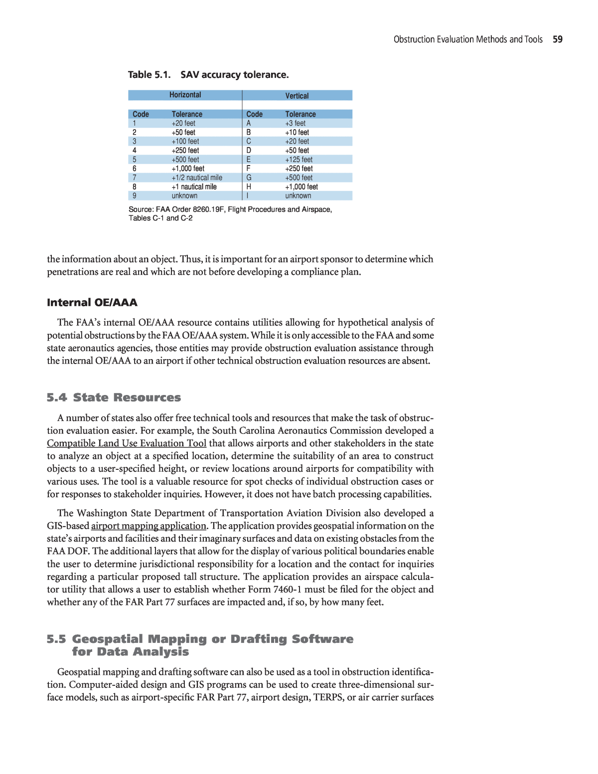
58 Best Practices for Airport Obstruction Management Guidebook While the SAV tool assesses the risk associated with each penetration, it is most useful for the analysis of 20:1 visual area surfaces for most straight-in approaches and 30:1 surfaces. The tool does not evaluate offset approach conditions, excessive DA conditions, or approaches with VDPs outside 10,000 feet. Therefore, it is most useful at less complex airports. It is important to note that the SAV tool only identifies objects known to the FAA. There may be objects unknown to the FAA that penetrate a surface. Thus, it is still the airport sponsorâs responsibility to verify all objects surrounding the airport. Within the SAV tool, there are seven tabs: 1. Airport: Used to define the runways and surfaces at the airport for analysis. 2. Visualization: Provides navigation of the map of the airport for viewing objects and surface penetrations for different angles. This tab can also be used to update or add new objects and use tools to manipulate map features. 3. Verification: A list of object identifiers and data regarding the objects that penetrate the surfaces defined for the airport. All objects in the SAV tool are initially assumed to be valid. An airport is responsible for determining whether an object is valid and can indicate that an object is invalid, but is required to write a comment to support the change. When the status of an object is changed, the appropriate FAA personnel are notified. 4. Penetration report: Reviews all objects that penetrate a surface, with the amount of penetra- tion and risk level. The objects are listed from highest to lowest risk in the 20:1 surface, fol- lowed by 30:1 penetrations. 5. Compliance plan: Airport sponsors are required to develop a plan to address valid surface penetrations. The FAAâs flight procedures team notifies an airport sponsor within 3 business days of being informed of a penetration affecting an IAP. The airport sponsor must acknowl- edge receipt of the notification and then must use the SAV tool to verify the validity of each penetration as soon as possible within 30 days. If no response is received from the airport sponsor, the FAA restricts the IAP. Based on the risk level, the sponsor has varying periods in which to address the penetration. For a high risk level, mitigation actions (remove, light, lower) must be taken as soon as possible, and mitigation action is needed before the FAA will remove any restrictions to the IAP. For a medium risk level, a compliance plan must be developed to complete mitigation actions as soon as possible within 180 calendar days. For a low risk level, a compliance plan must be developed to complete mitigation actions as soon as possible within one year. 6. Mitigation summary: Contains two tabs. One tab is for object information. The other is for mitigation information. The mitigation action tab allows authorized SAV users to update information, confirm and accept any updates or plans made for any object in the system, request FAA attention, or save updates to the FAA database. Once changes are made to the FAA database, the date of the change is recorded. 7. Notes: Lists all notes entered to support the verification, penetration report, and compliance plan, or mitigation summary tables. It includes the name of the user submitting the notes and the object identifier, slope associated with the object, and date and time of the note. The SAV tool, SAV tool userâs guide, and a quick reference guide can be accessed from the Airports GIS homepage. Additional details on the SAV tool are available at Airports GISâSurface Analysis & Visualization. This website includes screen captures of each of the tab pages. There are unverified objects within the database used for the SAV tool due to merging FAA databases in the Obstacle Authoritative Source. If an object is identified as an obstruction in the tool, one of the responsibilities of the airport sponsor is to verify the object. Table 5.1 shows the accuracy tolerance codes used in the tool. The lower the accuracy tolerance, the more accurate
Obstruction Evaluation Methods and Tools 59 the information about an object. Thus, it is important for an airport sponsor to determine which penetrations are real and which are not before developing a compliance plan. Internal OE/AAA The FAAâs internal OE/AAA resource contains utilities allowing for hypothetical analysis of potential obstructions by the FAA OE/AAA system. While it is only accessible to the FAA and some state aeronautics agencies, those entities may provide obstruction evaluation assistance through the internal OE/AAA to an airport if other technical obstruction evaluation resources are absent. 5.4 State Resources A number of states also offer free technical tools and resources that make the task of obstruc- tion evaluation easier. For example, the South Carolina Aeronautics Commission developed a Compatible Land Use Evaluation Tool that allows airports and other stakeholders in the state to analyze an object at a specified location, determine the suitability of an area to construct objects to a user-specified height, or review locations around airports for compatibility with various uses. The tool is a valuable resource for spot checks of individual obstruction cases or for responses to stakeholder inquiries. However, it does not have batch processing capabilities. The Washington State Department of Transportation Aviation Division also developed a GIS-based airport mapping application. The application provides geospatial information on the stateâs airports and facilities and their imaginary surfaces and data on existing obstacles from the FAA DOF. The additional layers that allow for the display of various political boundaries enable the user to determine jurisdictional responsibility for a location and the contact for inquiries regarding a particular proposed tall structure. The application provides an airspace calcula- tor utility that allows a user to establish whether Form 7460-1 must be filed for the object and whether any of the FAR Part 77 surfaces are impacted and, if so, by how many feet. 5.5 Geospatial Mapping or Drafting Software for Data Analysis Geospatial mapping and drafting software can also be used as a tool in obstruction identifica- tion. Computer-aided design and GIS programs can be used to create three-dimensional sur- face models, such as airport-specific FAR Part 77, airport design, TERPS, or air carrier surfaces Horizontal Vertical Code Tolerance Code Tolerance 1 +20 feet A +3 feet 2 +50 feet B +10 feet 3 +100 feet C +20 feet 4 +250 feet D +50 feet 5 +500 feet E +125 feet 6 +1,000 feet F +250 feet 7 +1/2 nautical mile G +500 feet 8 +1 nautical mile H +1,000 feet 9 unknown I unknown Source: FAA Order 8260.19F, Flight Procedures and Airspace, Tables C-1 and C-2 Table 5.1. SAV accuracy tolerance.
60 Best Practices for Airport Obstruction Management Guidebook specific to the airport. Using these models allows better evaluation and visualization of the potential impacts that a proposal may impose on airport operations and design. While mapping can be developed for airport use only, it also can potentially be adapted for use by local government staff and decision-makers and made available to the general public. The developed surfaces can be transferred into multiple software formats and adapted for use on local government GIS platforms or made available via the Internet. Because this solution is custom-built for each airport, it can be adapted and scaled to each airportâs comprehensive obstruction management program. In a limited-scope study, the airport may choose to model only a specific runway end or subset of surfaces (with FAR Part 77 being the most commonly modeled) for a simpler and less resource-intensive look at an obstruction management issue. In a more comprehensive solution, the airport might choose to model all FAR Part 77, design, TERPS, and air carrier surfaces for each of the runways and approaches. This is a more costly solution, which in turn produces a highly comprehensive âsnapshot in timeâ dataset. This dataset can be used as a base conditions file for a new comprehensive airport obstruction management program, to evaluate the condi- tions with long-term plans in mind or to undertake a thorough obstruction removal project that addresses all airport needs. Airports considering the development of individual surfaces for analysis, especially outside of a planning process, should be aware that the process of creating individual surfaces in design or drafting software can be time consuming, depending on facility complexity and number of approaches. A high level of expertise is required to evaluate the airport and all pertinent criteria and create the surfaces, and a level of airport staff expertise is required to operate and maintain the surfaces and the data as the airport evolves. If new obstructions are identified, the data files have to be manually updated unless a custom utility is created and used to regularly upload data from the FAA to the internal database. Lastly, the airport will need to monitor federal regulations pertaining to all designed surfaces and implement any changes to them in case of amendments to regulations and criteria. Alternatively, the airport may use the services of a consultant or expert to monitor data and regulations and update tasks. Taken a step further, with the use of custom applications and utilities, the surface maps can be made interactive and integrated with other local government data. If an airport creates indi- vidual surfaces, it may choose to take the process to the next level by transforming individual surfaces into a composite surface map, as discussed in Chapter 6. The collected obstruction data can easily be compiled into formats compatible with common software and used for an obstruc- tion analysis and a visual representation of obstruction issues. The data are frequently collected and assessed as part of drawing airport, inner approach, and departure surfaces in an ALP. 5.6 Software Solutions for Airspace Analysis and Airspace Obstruction Management The aviation industry offers a number of custom-tailored software solutions for airports seek- ing to implement airport obstruction management as an ongoing program. These programs are generally connected to FAA data sources and are able to extract obstruction data available to the agency in nearly real time. Because the solutions are customizable or custom-made, the set of capabilities to process, analyze and visually display obstruction data is extremely broad, limited solely by the sourced data and the airportâs budget. The ACRP Project 09-16 research team evaluated many programs designed to conduct airspace analysis. During the evaluation, the team focused on identifying software that would
Obstruction Evaluation Methods and Tools 61 generally be available to airport sponsors. A number of identified airspace analysis solutions were tailored to analysis of the airport or terminal airspace for criteria that are important to airline planners and performance engineers, such as traffic flow and airspace capacity, rather than to criteria important for airport obstruction management. The subset of software aimed at addressing airport obstruction management needs varied in analysis focus, ability to interact with the FAAâs data sources, and in providing user ability to customize the evaluation criteria and obstruction data. The best way to identify potential software solutions is to do an Internet search. In an Internet search, there are a number of terms that can help determine what product best meets the airportâs needs. For example, searching for âairspace obstacle evaluationâ or âairport obstacle evaluation softwareâ will identify numerous solutions to help airports meet FAR Part 77 requirements for OE/AAA. Searching for âairport airspace evaluationâ will yield similar results, but will also list software that offers airspace modeling and air traffic simulation capabilities. Many software vendors offer several solutions at varying costs or subscription fees, depending on the specific requirements. Therefore, based on the teamâs research and analysis, it is critical that the airport sponsor identify the specific objectives for the software solution and conduct a search that focuses on capabilities that most closely align with the airportâs needs. Some questions managers and planners should consider are the following: ⢠Does the software focus on analyzing the current FAR Part 77 requirements? ⢠Is the software interactive and does it allow users to alter imaginary surface designs and criteria to test and evaluate the effects and obstruction data prior to submission to the FAA? ⢠Does the software use existing data from Airports GIS? ⢠Does the software have the capability to use GIS data to create airspace analysis visual aids? ⢠Does the software combine airspace modeling with obstruction evaluation capabilities? ⢠Does the software link with the FAAâs OE/AAA module and database to automatically update its internal database with on-airport development proposals? The range of capabilities for customizable software solutions is broad; therefore, it requires a clear understanding of specific airport needs and the availability of resources and internal staff expertise to appropriately evaluate the solution that best complements the airportâs obstruction management program. Because federal aviation regulations and FAA standards are subject to change and individual airport needs and resources vary greatly, after identifying the airportâs criteria, the airport sponsor should research software to identify the solution that will fit the airportâs needs. While solutions can be researched online or through peer-to-peer consultation, appropriate public procurement steps may need to be followed for the acquisition.
