


Below is the uncorrected machine-read text of this chapter, intended to provide our own search engines and external engines with highly rich, chapter-representative searchable text of each book. Because it is UNCORRECTED material, please consider the following text as a useful but insufficient proxy for the authoritative book pages.
1 CHAPTER 1. INTRODUCTION TO THE TECHNICAL APPENDIX: UNDERSTANDING LONG-DISTANCE TRAVEL MARKETS 1(A) INTRODUCTION AND STRUCTURE OF THIS TECHNICAL APPENDIX Introduction This Technical Appendix to ACRP Research Report 204 is presented to provide the interested reader with support documentation in considerably greater detail than possible within the space constraints of the report. The document covers the same content as ACRP Research Report 204, but in a format that gives the reader access to more information than possible in the shorter report. As such, some text included in ACRP Research Report 204 has NOT been deleted from this document, in order to make the Technical Appendix readable for those who want more back- up information. Some of the text, thus, overlaps with text in the report. The content of the Technical Appendix is presented in chronological order: subject areas are ordered in terms of when the work was done. Chapters 1â5 in this Technical Appendix present the results of the research program about information available before the undertaking of our ACRP 2017 survey. These five chapters cover the same technical areas as Chapters 2â4 of ACRP Research Report 204 but contain far more back-up information. Chapters 6â12 are presented to summarize and interpret the results of the projectâs year 2017 survey, and to document the modeling efforts based on those results. Most of the results of the scenario testing exercise are presented in ACRP Research Report 204. Structure This Technical Appendix for ACRP Research Report 204: Air Demand in a Dynamic Competitive Context with the Automobile is presented in 12 chapters. ï· Chapter 1. Introduction: Understanding Long-Distance Travel Markets ï· Chapter 2. Understanding the Role of Distance in Choice of Mode ï· Chapter 3. Defining Corridors Where Modes Compete ï· Chapter 4. The Location of and Factors for Competition Among Airports ï· Chapter 5. Examples of Forecasts of the Future ï· Chapter 6. Data Collection, Sampling Plan, and Description of the 2017 Survey ï· Chapter 7. Latent Class Cluster Analysis for Market Segmentation ï· Chapter 8. Travel Behavior and Attitudes toward the Long-Distance Trip, Results of the 2017 Survey ï· Chapter 9. An Attitude-Based Model of the Long-Distance Choice of Mode ï· Chapter 10. Mixed Logit Models for Scenario Creation ï· Chapter 11. The Hybrid Choice Model for Scenario Testing ï· Chapter 12. Model Calibration and Validation of the Scenario Testing Model 1(B) DEMOGRAPHICS AND THE LONG-DISTANCE TRIP ACRP Research Report 204: Air Demand in a Dynamic Competitive Context with the Automobile has been created to improve the understanding of how travelers make the decision
2 between air and auto. This section of the Technical Appendix reviews basic information about why the trips are made, who is making them, where they are being made, and how much is spent on them. After this review of long-distance trip-making by all modes, this chapter of the Technical Appendix will examine first trips by air, and then trips by car in more detail. The major source for comprehensive data about long-distance trips and the demographics behind those trips is the American Travel Survey, undertaken in 1995. Although this Technical Appendix will document the results on many separate studies designed to update, and estimate national longer-distance travel, the 1995 ATS will serve as the base-year data source, particularly for analysis of change in behavior over time. REASONS FOR LONG-DISTANCE TRIPS, FROM THE BASE YEAR ATS SURVEY, 1995 In our base-year data, people are not primarily making long-distance trips exclusively for business or even partly for business. Figure 1-1 shows that only 24% of long-distance trips are made for business purposes; another 12% of trips are made for personal business. The remaining 64% of trips comprise long-distance trip-making for either visiting friends and relatives or for leisure activities. Leisure is the largest trip purpose reported in Figure 1-1; this category is disaggregated in Figure 1-2. The highest portion of the large leisure category is rest and relaxation, followed by outdoor recreation, entertainment, sightseeing, and finally shopping. Approximately two-thirds of trips are made for nonbusiness reasons, whether that is defined as work-related or personal trips. FIGURE 1-1: PERCENT SHARE FOR FOUR CATEGORIES OF TRIP PURPOSE, 1995 Source: McGuckin from American Travel Survey, 1995. Business and Mixed, 24% Visit , 31% Leisure, 32% Personal Business, 12%
3 FIGURE 1-2: COMPONENT ELEMENTS WITHIN âLEISUREâ CATEGORY. 1995 Source: McGuckin from American Travel Survey, 1995. LONG-DISTANCE TRIP-MAKERS The publication of TRB Special Report 320: Interregional TravelâA New Perspective for Policy Making, was a major contribution to the study of long-distance, interregional trip-making. This report provides data and interpretation of data that are relevant to this study of the competition between travel by air and the automobile. The research for TRB Special Report 320 prioritized trips in which automobiles, buses, and rail were all viable competitors to the airplane for long- distance trip-making. Nancy McGuckin, a member of the current research team, undertook a review of the data from the last major national study of long-distance travel, the American Travel Survey (1995), for TRB Special Report 320. That workâand the research to support itâfocused on trips in the highly competitive distance between 100 and 500 miles, where bus and rail options are most relevant. , 11% Sightseeing, 4% Outdoor Recreation, 7% Entertainment, 6% Shopping,2%
4 THE ROLE OF AGE IN LONG-DISTANCE TRIP-MAKING FIGURE 1-3: ANNUAL MEDIUM TRIPS PER PERSON, BY AGE GROUP (1995) Source: McGuckin from American Travel Survey, showing trips between 100 and 500 miles. Using the measure of annual trips per person, Figure 1-3 shows that long-distance trip-making increases until ages 50â64, and then decreases; individuals 80 years or older have the lowest rates of long-distance mobility. Almost 70% of trip-making for all purposes in this distance category is joint travel, while 30% is people traveling alone. Seventy-six percent of business trips are people traveling alone in a single party, while only 15% of leisure travel is by single-party travelers. (NAS Report/McGuckin). THE ROLE OF INCOME IN LONG-DISTANCE TRIP-MAKING Figure 1-4 illustrates the relationship between income and long-distance trip-making. The highest-income quartile of the American population takes more than twice the number of long- distance trips (5.1 personal trips per year) of the lowest-income quartile of the population (2.3 person trips per year) in 1995. 2.6 3.7 4.9 5.6 3.6 1.4 0.0 1.0 2.0 3.0 4.0 5.0 6.0 Children 15 and younger 16-29 30-49 50-64 65-79 80 years and older An nu al In te r-r eg io na l T rip s Age Category
5 FIGURE 1-4: ANNUAL MEDIUM TRIPS PER PERSON, BY INCOME QUARTILE (1995) Source: American Travel Survey, showing trips between 100 and 500 miles. THE CONCEPT OF THE TOP 200 CORRIDORS The NAS Report on Interregional Travel (2016) focused analytical attention on 200 intercity corridors between 100 miles and 500 miles in length. The definition of a single comparative study population provided a workable definition of markets by the Committee responsible for developing the Special Report. While the focus of the present ACRP study is the competition between air and highway, the Special Report concerned the interaction between/among rail, bus, highway, and air together; this resulted in the decision to focus on corridors under 500 miles long. Figure 1-5 is reproduced directly from the NAS Report and shows corridors between 100 and 500 miles in length. The NAS Committee sought new information to understand long-distance service marketsâ scale. The Committee was supported by the Federal Highway Administration (FHWA), which authorized the use of trip table data still (at that time) under development by the agency and consultants to the agency. The Committee was primarily interested in understanding the scale of trip-making for trips over 100 miles and under 500 miles, a category in which air and rail are in active competition, and a category in which rail and bus volumes would also be meaningful. This category is relevant to the present analysis of the role of air in competition with the automobile trip accomplishable within one day (i.e., not requiring lodging while en route). As the authors noted, the NAS Report used data provided by FHWA: To compensate for the lack of more recent data, FHWA used the 1995 ATS data to estimate the number of automobile and bus trips made in 2008. Linear regression equations were developed that explained the 1995 ATS results on the basis of 1995 Census Bureau employment and demographic data. Estimates for 2008 were then made by using 2008 Census Bureau data as input for the explanatory variables in the equations. (NAS Report) 2.3 3.5 4.2 5.1 0 1 2 3 4 5 6 Lowest Income Quartile Second Lowest Quartile Second Highest Quartile Highest Income Quartile An nu al In te r-r eg io na l T rip s Income Category
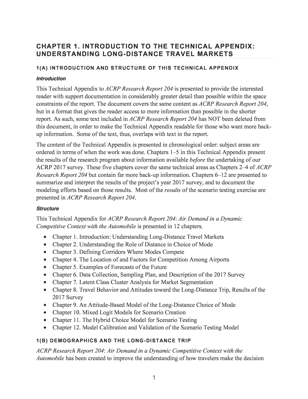
6 FIGURE 1-5: TRAVEL CORRIDORS BETWEEN 100 AND 500 MILES IN LENGTH Source: NAS Interregional Travel Report. COSTS EXPERIENCED FOR EACH MODE The Bureau of Transportation Statistics (BTS) has published a valuable summary of transportation statistics, Passenger Travel Facts and Figures 2016, which details long-term travel. Figure 1-6 includes a summary of the average expenditure on transportation in the year of 2014. According to these data, the âaverageâ American spent $370 per year for airline fares. This can be compared with the expenditure of about $8,500 per year to support the privately-owned automobile. Of this amount, approximately $3,300 (or nearly 40%) was associated with âvehicle purchase,â sometimes called depreciation.â The rest of the costs are not associated with âpurchaseâ and may or may not vary directly with incremental mileage undertaken. The question of just how much the costs of driving vary on a per-mile basis is investigated in Chapter 8 of this Technical Appendix, which explores both the concept of âfully allocated costsâ and various perceptions of what is meant by âout-of-pocket costs.â Thus, when a possible long-distance trip is considered, significant capital has already been expended to retain access to, and use of, a private automobile. Other figures in the âFacts and Figuresâ DOT report show that the cost of owning and operating an automobile in 2014 is virtually the same as it was in 1990, when expressed in constant dollars. (Automobile costs in 2014 were down somewhat from a higher level experienced in 2000.) The cost of an airline ticket in 2014 was down by 22% compared with 2000 (in constant dollars). (Additional fees for baggage and other related expenses were not included in that analysis.)
7 FIGURE 1-6: AVERAGE HOUSEHOLD EXPENDITURE BY SPENDING CATEGORY (2014) Source: Bureau of Transportation Statistics, Passenger Travel Facts, Figure 4-4. 1(C) UNDERSTANDING MARKET TRENDS FOR AIR TRAVEL Air travel data are the most accurate and the most readily available to researchers because of the federal agenciesâ interest in and oversight of air travel. Federal Aviation Administration (FAA) publishes its update of the Terminal Area Forecast (TAF) Summary annually, which âprovides aviation data users with summary historical and forecast statistics on passenger demand and aviation activity at U.S. airports. The summary level forecasts are based on individual airport projections.â The latest version is TAF 2017â2045. HISTORICAL TRENDS IN ENPLANEMENT Airport activity data for the period between 1995 and 2017 is summarized in Figure 1-7, taken from several TAF reports.
8 FIGURE 1-7: HISTORY OF GROWTH IN AIRPORT ENPLANEMENT (1990â2015) Source: Federal Aviation Administration, TAF Summaries The enplanement data illustrate the effects of two periods of economic upheaval. Most important for the aviation sector (and not for the highway sector) was the sharp decline between 2000 and 2002, which includes the passenger market reaction to September 11. Equally dramatic is the response of the market between 2003 and 2007, where the previous levels were regained, and increased upon substantially. The volumes at airports in the summer of 2007 were at an all-time high, with significant congestion occurring at busy airports like JFK. From 2008 to 2009, during the depths of the Great Recession, the graph shows a sharp decline like that experienced in 2002. The industry rebounded with enplanement levels finally rising above those of 2007 by the end of 2015. In the study of modal choice between the auto and the air services, it is particularly important to look at per-capita patterns of transportation behavior, in this case change in per-capita rates of enplanement. Chapter 8 of this Technical Appendix will review the implications of these trends in enplanements in the context of per-capita usage patterns, and in terms of complete air trip, which often requires two segment-enplanements per trip. The travel patterns between 2007 and 2012 were further examined in "Aviation Industry Performance: A Review of the Aviation Industry 2008-2011" from the Office of Inspector General, US DOT. The chart taken from that report (Figure 1-8) illustrates the decrease in airline service as a function of distance of the flight segment. Clearly, this decrease in airline services between 2007 and 2012 occurred most strongly for light segments under 500 miles and almost entirely for flights under 1,000 miles. The research team has included this chart in this report to emphasize the fact that fewer flight segments are offered, affecting the combined frequency of  350  450  550  650  750  850  950 19 95 19 96 19 97 19 98 19 99 20 00 20 01 20 02 20 03 20 04 20 05 20 06 20 07 20 08 20 09 20 10 20 11 20 12 20 13 20 14 20 15 20 16 20 17 En pl an em en ts , i n M ill io ns Year Growth in Enplanements, 1995 â2017
9 flights from any given airport. In the evolution of services that occurred, airline resources were reallocated from shorter-distance segments to longer-distance segments. There is empirical data on air and automobile trip-making until 2002, with air-only data available for subsequent years. Implicit is that the role of the automobile in the short-distance trip market has increased significantly over the past 20 years and is markedly different from the role indicated by the 1995 data. FIGURE 1-8: DECREASE IN AIRLINE SERVICE BY DISTANCE OF FLIGHT SEGMENT (2007â2012) Source: Office of Inspector General (2012). "US DOT Aviation Industry Performance: A Review of the Aviation Industry 2008-2011â Reproduced from Figure 26, page 29. PRESENT AND FUTURE ENPLANEMENTS The FAA developed a process for its terminal area forecasting that resulted in the regional growth forecasts shown Figure 1-9. These growth patterns are expressed in terms of FAAâs forecast for the growth of enplanements at its âCore Airportsâ (Figure 1-10). The method behind these predictions is summarized in the 2016 TAF Summary: The forecasts of passenger enplanements and commercial operations at airports with more than 100,000 enplanements in FY 2014 are based on a bottoms-up approach. The domestic enplanements are forecast by generating origin and destination (O&D) market demand forecasts using the DB1B (quarterly 10% sample) data to model passenger flow on a quarterly basis. The O&D passenger demand forecasts are based on regression analysis using fares, regional demographics, and regional economic factors as the independent variables. The O&D forecasts are then combined with DOT T-100 segment
10 data to generate passenger forecasts by airport pair and segment pair. The segment pair passenger forecasts are assigned to aircraft equipment in order to produce segment pair operation forecasts. (Quote from page 4.) The reference to âregression analysis using fares, regional demographics, and regional economic factors as the independent variablesâ refers to an ongoing program to improve the quality of FAA forecasts and to relate their predictions to demographic factors, often created by others. This method was first published in the FACT 2 Report several years earlier. FIGURE 1-9: PROJECTED GROWTH IN AIRPORT ENPLANEMENTS, BY REGION (2015â2040) Source: FAA, TAF 2016. 0% 10% 20% 30% 40% 50% 60% 70% 80% NW Mountain Mountain (ANM) New England (ANE) Southern (ASO) Western Pacific (AWP) Southwest (ASW) Central (ACE) Eastern (AEA) Great Lakes (AGL) Alaska (AAL) National Total Pe rc en t G ro w th  RegionÂ
11 FIGURE 1-10: ENPLANEMENTS AT CORE AIRPORTS (IN THOUSANDS) Source: TAF, 2016. THE âFACTâ REPORTS FROM THE FAA FAA has published a series of reports concerning âAirport Capacity Needs in the Airspace System,â the latest of which is called the âFACT 3â report (2015). These important studies are integrated with the TAF data and provide interpretations of how airport capacities are and are not adequate to deal with expected aviation demand. The âFACT 2â report explained how The MITRE Corporation created an experimental process to improve the forecasting process for the FAA. The report, written several years before the work discussed here, described the following (The MITRE Corporation, 2007): [A] bottom-up model of origin and destination (O&D) traffic. This socio-economic model, known as the Future Air Traffic Estimator (FATE), is based on the economic and
12 demographic characteristics of individual pairs of origin destination metropolitan areas. This is a different approach than that taken by the TAF, as it estimates the amount of passenger traffic between metropolitan areas rather than estimating demand at individual airports. Population, income, and market structure all influence passenger demand, as does a host of other factors. Inputs to the model include socio-economic forecasts from the consultancy Global Insight, as well as historical data on O&D traffic from the Department of Transportation. The process applied in the FACT 2 Report included a diagram shown here in Figure 1-11, which was explained as follows: [T]he FATE socio-economic model begins by forecasting O&D passengers between metropolitan areas. Then, for each origin destination pair, passengers are allocated among available routes, taking into account the existing air carrier network structure. Note that if there are multiple airports within a metropolitan area, passengers are assigned to one of them as part of this âairport choiceâ process. This process is then repeated for all O&D pairs in the conterminous United States. FIGURE 1-11: EVOLVING METHODS FOR AVIATION FORECASTING Source: Diagram from the FACT 2 Report.
13 1(D) UNDERSTANDING MARKET TRENDS FOR THE AUTOMOBILE HISTORICAL TRENDS IN VMT PER CAPITA BETWEEN 1995 AND 2015 The recent history of automobile travel includes a pattern of yearly increase in-vehicle travel per person, plateauing around 2004 or 2005, as shown in Figure 1-12. At this point, VMT no longer consistently increased, with a pattern of decline to about 2013. Interestingly, the 2005 flattening occurred several years prior to the recession of 2008, which also significantly affected aviation trip volumes. FIGURE 1-12: VEHICLE MILES OF TRAVEL PER CAPITA (1995â2017) Source: Federal Highway Administration; Year 2017 estimated from first quarter results by research team. RELATIONSHIP TO ECONOMIC GROWTH The timing of the flattening of the growth in VMT is reflected the examination of the relationship between VMT growth and gross domestic product (GDP) economic growth. The BTSâs Passenger Travel Facts and Figures report includes a graph (Figure 1-13) that charts GDP and VMT patterns between 1990 and 2014. The slope of the VMT line parallels the slope of the GDP between 1990 and 2005. The slope of the GDP line continued upward until the Great Recession, at which point it also declined. In short, the decoupling of VMT from the GDP pattern occurs somewhere around 2005 and continues downward until flattening at the end of the recession period around 2012. Figure 1-13 supports the argument that the alteration in the pattern of perpetual growth in automobile VMT cannot solely be attributed to larger economic patterns. VMT growth trailed the economic recovery until it reached prerecession levels by 2015. 8,600 8,800 9,000 9,200 9,400 9,600 9,800 10,000 10,200 10,400 VMT per Capita, 1995- 2017
14 FIGURE 1-13: COMPARISON OF GDP AND VMT PATTERNS (1990â2014) Source: Bureau of Transportation Statistics. Reproduced from Figure 4-2, Passenger Travel Facts and Figures, 2016 AIR AND AUTOMOBILE TRAVEL TOGETHER This research project examines the relationship between highway travel and air travel and the growth in the two modes. Figure 1-14 presents automobile travel and air travel growth lines in the form of an index of growth from 1991. This uses absolute growth in VMT (not VMT per capita, as applied in Figure 1-12) to compare absolute growth in enplanements. (Part of the growth in each travel mode is attributable to an increase in the national population over this period.) The relative volatility of the aviation enplanements compared with the automobile mileage is pronounced. Specifically, the sharp fall in aviation travel between 2000 and 2002 is not mirrored in the VMT data, which show nearly linear growth between 1992 and 2005. In short, the 2001 decrease in air travel simply did not happen in terms of absolute growth in VMT. Both air travel and automobile travel were affected by the recession of 2008. However, air travel experienced a steeper decline than travel by automobile. (N.B., the base volume of the VMT number is vastly larger than that of the aviation number, making relative change more difficult.) The currently (2017) available data demonstrate a strong rebound in both air travel and travel by automobile. (The reader should note that Figure 1-13 shows trends in all vehicle travel, not just long-distance travel.)
15 FIGURE 1-14: GROWTH IN ENPLANEMENTS AND VMT FROM 1991 0% 10% 20% 30% 40% 50% 60% Air Auto
