
10
Conclusions and Recommendations
10.1 INTRODUCTION
Chapters 10 and 11 form a pair. In Chapter 10, the committee derives six recommendations from its conclusions about the educational links between spatial thinking and GIS in the K–12 context. The thrust of the committee’s position is simple: spatial thinking is not being taught systematically to K–12 students at present. We need to do so, across the curriculum and for all K–12 students, because it is fundamental to everyday life, the workplace, and science. If we are to teach how to think spatially, then we need to provide both low- and high-tech support systems for practicing and performing spatial thinking. The recommendations range from the setting of research agendas to guidelines for software redesign, but underpinning all of these recommendations is a goal—spatial literacy. We must foster a new generation of American students who are equipped to think spatially.
Chapter 11, therefore, paints a picture of spatial thinkers at work, in this case eighth-grade students who are using GIS as a support system to help answer questions about the causes of high infant mortality rates in sub-Saharan Africa. This picture represents the best of supporting spatial thinking through GIS. It does not reflect the situation in the vast majority of American classrooms. Students are not systematically being taught to think spatially because as a society, we do not yet recognize the pervasiveness of spatial thinking and appreciate its power and value.
It is the strong belief of the committee that these six recommendations are a way to ensure that the next generation of American students will have the opportunity to meet the goal of becoming spatially literate.
10.2 CHARGE TO THE COMMITTEE
The title of the proposal that led to the formation of the committee was Support for Thinking Spatially: The Incorporation of Geographic Information Science Across the K–12 Curriculum. The charge contained two questions that logically followed from the proposal title:
-
How might current versions of GIS be incorporated into existing standards-based instruction in all knowledge domains across the school curriculum?
-
How can cognitive developmental and educational theory be used to develop new versions of GIS that are age appropriate in their design and to implement new GIS curricula that are age appropriate in their scope and sequence?
The first question was intended to generate recommendations for levels of technology (hardware and software), system support (e.g., software, hardware, teaching materials), curriculum scope and sequence (i.e., the role of necessary precursors), and pre-service and in-service training. The second question was intended to generate recommendations, based on an assessment of theoretical and empirical approaches in psychology and education that are relevant to the development of knowledge and skills that underpin the use of GIS.
However, as explained in Section 1.3, the committee recognized that these two questions could not be answered without first addressing the educational role of spatial thinking itself. New and better support tools for education—such as GIS—may well be necessary and appropriate, but to what purpose and in what contexts? The answer might seem obvious from the title of this report: to support spatial thinking across the K–12 curriculum. However, such an answer raises some fundamental questions: Why do we need to support spatial thinking across the K–12 curriculum? Why should we invest in better GIS or any other support tools?
After coming to appreciate the fundamental importance of spatial thinking and realizing that it was not just undersupported, but underappreciated, undervalued, and therefore underinstructed, the committee came to a new understanding of the charge. The two original questions about the current role and future development of GIS as a support system could be answered satisfactorily only after two additional questions were addressed, one about the need for spatial thinking and the other about the ways in which we learn to think spatially. Therefore, the committee developed an understanding of the nature and character of spatial thinking, leading to a more coherent and comprehensive set of recommendations. With this reorganization of the task, Part I of this report, “The Nature and Functions of Spatial Thinking,” led to Recommendation 1, and Part II, “Support for Spatial Thinking,” led to Recommendations 2–6.
10.3 THE NATURE AND FUNCTIONS OF SPATIAL THINKING
The committee arrived at a position on the educational necessity for teaching and learning about spatial thinking:
-
Spatial thinking is a collection of cognitive skills. The skills consist of declarative and perceptual forms of knowledge and some cognitive operations that can be used to transform, combine, or otherwise operate on this knowledge. The key to spatial thinking is a constructive amalgam of three elements: concepts of space, tools of representation, and processes of reasoning (see Section 1.2).
-
Spatial thinking is integral to everyday life. People, natural objects, human-made objects, and human-made structures exist somewhere in space and the interactions of people and things must be understood in terms of locations, distances, directions, shapes, and patterns (see Chapter 2).
-
Spatial thinking is powerful: it solves problems by managing, transforming, and analyzing data, especially complex and large data sets, and by communicating the results of those processes to one’s self and to others (see Chapter 2).
-
Spatial thinking is integral to the everyday work of scientists and engineers and it has underpinned many scientific and technical breakthroughs (see Chapter 3).
-
Spatial thinking is a skill that can—and should—be learned by everyone, but there are
-
significant individual and group differences in levels of performance (see Chapters 2 and 4 and Appendix C).
-
Spatial thinking develops uniquely in individuals depending on their experience, education, and inclination (see Chapter 4 and Appendix C).
-
Expertise in spatial thinking draws on both general spatial skills that cross many domains of knowledge and spatial skills that are particular to parts of a domain of knowledge (see Chapter 4).
-
Expertise in spatial thinking develops in the context of specific disciplines and becomes transformed and refined through training and extensive practice (see Chapters 3 and 4).
-
While transfer of spatial thinking skills from one domain of knowledge to another is neither automatic nor easy, appropriately designed curricula that encourage infusion across school subjects can facilitate transfer (see Chapter 4).
-
Spatial thinking is currently not systematically instructed in the K–12 curriculum despite its fundamental importance and despite its significant role in the sets of national standards for science, mathematics, geography, etc. (see Chapter 5). There is a major blind spot in the American educational system.
-
Support systems leverage the power of the human capacity to think and to solve problems (see Section 6.1).
-
Spatial thinking is a complex, powerful, and challenging process, and support systems provide an interactive environment within which spatial thinking can take place by helping students to spatialize data sets, visualize working and final results, and perform analytic functions (see Section 6.6).
-
Given the increasing need for lifelong learning skills in a technologically changing world, students need opportunities to learn a range of low- and high-tech support systems for spatial thinking (see Chapter 6).
-
Implementing any support system in the K–12 context requires coordinated programs for material, logistical, instructional, curriculum, and community support (see Section 6.4).
Therefore, the committee views spatial thinking as a basic and essential skill that can be learned, that can be taught formally to all students, and that can be supported by appropriately designed tools, technologies, and curricula. With appropriate instruction and commensurate levels of low- and high-tech support, spatial thinking can become an invaluable, lifelong habit of mind.
However, the problem with respect to teaching and learning about spatial thinking is far deeper than simply a lack of adequate supporting tools. Tools are a means to an end: tools are therefore necessary but not sufficient. Schools teach what society values. Society values that for which there is a clear and explicit need and, therefore, educational rationale. Thus, two of the most valued school subjects are mathematics and science. As Chapter 5 makes clear, however, underpinning success in both mathematics and science is the capacity to think spatially. Also, as Chapter 3 makes clear, spatial thinking underpins many tasks in everyday life, the workplace, and science. Ironically, these underpinnings are not yet matched by either a deep scientific understanding of the process of spatial thinking or a broadly accepted educational rationale and therefore mandate for learning how to think spatially.
The committee believes that Chapters 3 and 5 provide a powerful educational rationale for teaching spatial thinking. Chapter 2 offers a first attempt to describe and understand the process of spatial thinking, and Chapter 4 and Appendixes C and D summarize what we know about the learning and teaching of spatial thinking, leading to a position statement on the fostering of expertise in spatial thinking (see Section 4.5).
Chapter 5 demonstrates that there is no systematic and comprehensive attempt to teach about spatial thinking as part of the national science and mathematics standards. Nowadays, school curricula are designed to meet subject-based content standards, of either national or state origin,
that express what students should know and be able to do at various points throughout their school careers. Schools, and increasingly society at large, measure their success against benchmarks using standards-based assessments. As the educational saying goes, “We assess what we value and we value what we assess.”
There are neither content standards nor valid and reliable assessments for spatial thinking. Without such standards and assessments, spatial thinking will remain locked in a curious educational twilight zone: extensively relied upon across the K–12 curriculum but not explicitly and systematically instructed in any part of the curriculum. No matter how well designed support tools for spatial thinking might be, they will not be effective without a societal recognition of the importance of spatial thinking and an educational commitment to teaching spatial thinking to all students in all grades.
However, spatial thinking itself is not a content-based discipline in the way that physics, biology, or economics are disciplines: it is not a stand-alone subject in its own right. Spatial thinking is a way of thinking that permeates those disciplines and, the committee would argue, virtually all other subject matter disciplines. Instruction in spatial thinking should play an equivalent role to that of the “writing across the curriculum” approach. Standards for spatial thinking, therefore, should be general guidelines for what students need to know about concepts of space, tools of representation, and processes of reasoning in order to be able to solve problems. These general guidelines—elements of which are illustrated in Chapter 2—must be correlated with and integrated into the particular content knowledge expectations for various subject matter disciplines. The guidelines should, therefore, be infused across the curriculum and supported in as many disciplines as possible.
Spatial thinking is not an add-on to an already crowded school curriculum but a missing link across the curriculum. Integration and infusion of spatial thinking can help to achieve existing curricular objectives. Spatial thinking is another lever to enable students to achieve a deeper and more insightful understanding of subjects across the curriculum.
Instruction in spatial thinking would help to foster a new generation of spatially literate students who are proficient in terms of spatial knowledge, spatial ways of thinking and acting, and spatial capabilities (see Section 1.4.1). With this proficiency, students will have established the habit of mind of thinking spatially, seeing opportunities for approaching problems by using their knowledge of concepts of space. They will be able to practice spatial thinking in an informed way, drawing on their knowledge of tools of representation. They will adopt a critical stance to spatial thinking, using the appropriate processes of spatial reasoning (see Section 1.4.2). Chapter 11 shows eighth-grade students practicing spatial thinking in a remarkably sophisticated way with the support of a tool, GIS, and with the guidance of an enlightened teacher.
The first recommendation is designed to help achieve the goal of spatial literacy for all American students.
Recommendation 1
Through the support of federal funding agencies (i.e., National Science Foundation [NSF], the National Institutes of Health, and the Department of Education), there should be a systematic research program into the nature, characteristics, and operations of spatial thinking. The NSF competition for “Science of Learning Centers” provides one program model for developing knowledge about spatial thinking.
The findings of this research program would be expected to highlight the importance of spatial thinking across the K–12 curriculum as well as to encourage the development of spatial thinking standards and curriculum materials to train K–12 students in spatial thinking.
The ultimate goal should be to foster a new generation of spatially literate students who have
the habit of mind of thinking spatially, can practice spatial thinking in an informed way, and can adopt a critical stance to spatial thinking. Meeting this long-term goal will require careful articulation of the links between spatial thinking standards and existing disciplinary-based content standards. It will necessitate the development of innovative teaching methods and programs to train teachers, together with new ways to assess levels of spatial thinking and the performance of educational support programs. There should be a national commitment to the systemic educational efforts necessary to meet the goal of spatial literacy.
10.4 SUPPORT FOR SPATIAL THINKING
The committee arrived at a position on the educational challenges of providing systems for supporting spatial thinking in K–12 education:
-
Spatial thinking can be supported and facilitated by the development of a coherent suite of supporting tools, ranging from low to high technology in nature, that can (1) address a range of types of problems, (2) use a range of types and amounts of data, and (3) require different levels of skill and experience (see Chapter 6).
-
Support systems for spatial thinking must meet three requirements: they must (1) allow for the spatialization of data, (2) facilitate the visualization of working and final results, and (3) perform a range of functions (transformations, operations, and analyses) (see Chapter 6).
-
The success of a support system in the K–12 context is a function of its design (see the 10 criteria in Chapter 6) and its implementation across the curriculum (see the five support needs in Chapter 6).
-
GIS has significant but as yet unrealized potential for supporting spatial thinking across a range of subjects in the K–12 curriculum (see Chapters 7, 8, and 9).
-
However, there are significant design and implementation challenges to be met before GIS can play a significant role alongside other tools for teaching standards-based spatial thinking across the curriculum. GIS should be redesigned to accommodate the full range of learners and school contexts, to be more developmentally and educationally appropriate, to be easier to teach and to learn, and to accommodate current levels of computing equipment in schools (see Chapters 8 and 9).
-
GIS must be supported by a systematic implementation program that incorporates teacher training, curriculum development, and material support (see Chapters 8 and 9).
The committee sees GIS as exemplifying the theoretical power of a high-tech system for supporting spatial thinking and the practical design and implementation problems that must be faced in the K–12 context:
-
The power of GIS lies in its ability to support the scientific research process and to provide policy-related answers to significant real-world problems arising in a variety of disciplinary contexts.
-
The appeal of GIS lies in its direct connection to significant workforce opportunities in the information technology sector.
-
The potential of GIS lies in its ability to accommodate the full range of learners and to be adapted to a range of educational settings.
-
The practical problems of adapting GIS to the K–12 context are equally striking. As an expert-based, “industrial-strength” technology, it is, in one sense, too powerful for most K–12 needs. It is challenging and inviting, yet intimidating and difficult to learn. While the design issues can be addressed, the implementation challenges are immense. All of the essential implementation
-
supports—for materials, logistics, instruction, curriculum, and in the community—are either weak or nonexistent.
Therefore, while GIS can make a significant impact on teaching and learning about spatial thinking, it must be situated in a context wherein there is a systematic, standards-based approach to teaching spatial thinking and there is a suite of supporting tools available to do so. Taken alone, GIS is not the answer to the problem of teaching spatial thinking in American schools; however, it can play a significant role in an answer. For GIS to be able to play that significant role, the committee identified a set of five recommendations.
Recommendation 2
There should be a coordinated effort among GIS designers, psychologists, and educators to redesign GIS to accommodate the needs of the K–12 education community. Among the many design issues that must be addressed are
-
broadening its accessibility to the full range of learners (e.g., adding alternative sensory input and output modes);
-
strengthening the capacity to spatialize nonspatial data;
-
overcoming the visualization limitations (e.g., with respect to time and to full 3-D capacity);
-
providing graded versions of GIS that are age and/or experience appropriate (e.g., that are easy to learn, cumulative, and flexible);
-
redesigning interfaces to be more intuitive and to provide help and guidance (e.g., providing reflective wizards);
-
making the software customizable (e.g., adopting an open system architecture; making it possible for teachers to hide or expose functionality as needed); and
-
making the software “teacher friendly” in terms of ease of installation, maintenance, and use.
The committee recognizes that many of these design challenges are not specific to the K–12 context and that their solution may not occur with this context in mind. Should that be the case, then someone must take responsibility for adapting the solutions to the particular needs of teachers and students. Teachers and students should not be expected to adapt to a “one-size-fits-all” GIS that does not reflect their special needs.
The committee identified three mechanisms that led to the development of GIS software: the academic model, the commercial model, and the collaborative model. These three models offer distinct options for the redesign of GIS software for the K–12 context. All three mechanisms appear to have merit, as well as potential pitfalls. The choice between them, therefore, should be made by the appropriate funding agencies.
Based on the levels of investment being made by commercial vendors, and on experience from GIS development projects, it would be reasonable to assume that a suitable GIS could be developed over a period of three years. Therefore:
Recommendation 3
To coordinate the development of GIS software, a “Federation of GIS Education Partners” should be established. The federation should consist of GIS developer and user partners, drawn from academia, government, the private sector, and the K–12 user community.
To be successful, the following should be considered in the design of a GIS educational software federation:
-
The federation should be a grass-roots, community-driven effort.
-
The governance basis of the federation should be a bottom-up (rather than a top-down approach) to ensure that the priorities of the broader community are honored. However, some centralized management would be necessary for making major decisions on behalf of the federation’s constituents, for representing the federation’s interests, and for conducting day-to-day operations. The instrument of centralized management should be used sparingly.
-
The federation should be flexible. Thus, the initial rules and procedures should not be over specified.
-
The federation should manage the tensions that may arise from constituents with differing expectations (e.g., software companies, teachers).
Recommendation 4
Working in collaboration, GIS system designers, educational IT specialists, and teachers should develop guidelines for a model GIS-enabled school.
The guidelines should address software and hardware needs (including schedules for upgrades), local and global network design and access requirements, classroom layouts for different modes of instruction, and levels of technical support for hardware and software.
Recommendation 5
Working in collaboration, representatives of colleges of education and GIS educators should
-
establish guidelines for pre- and in-service teacher training programs for teaching spatial thinking using GIS; and
-
develop a model standards-based curriculum for teaching about GIS.
Recommendation 6
With funding from either a government agency (e.g., NSF, the Department of Education) or a private philanthropy, a research program should be developed to see whether or not an understanding of GIS improves academic achievement across the curriculum. Without credible assessment of results, the value of GIS and other support systems for spatial thinking cannot be evaluated.
This set of recommendations (2–6) contains overlaps and critical interdependencies. Thus, for example, the GIS redesign process must inform the development of guidelines for GIS-enabled schools. The model curriculum must be linked to assessment procedures and to the research program on the impact of GIS on academic achievement. (See Figure 10.1 for an implementation timetable.)
10.5 CONCLUSION
The premise for this report is the need for systemic educational change. Fundamental to that change is a national commitment to the goal of spatial literacy. Spatial thinking must be recognized
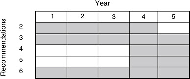
FIGURE 10.1 Timetable for implementing Recommendations 2–6.
as a fundamental and necessary part of the process of K–12 education. The committee does not view spatial thinking as one more piece to be added on to an already overburdened curricular structure. In contrast, spatial thinking is viewed as an integrator and a facilitator for problem solving across the curriculum. Spatial thinking does not and should not stand alone, but equally well, without explicit attention to it, we cannot meet our responsibility for equipping the next generation of students for life and work in the twenty-first century. Chapter 11 shows what can be achieved by using one high-tech support system, GIS, to engage students in scientific problem solving.


