
11
The Spatial Thinker
11.1 GIS AND THE CHALLENGE OF THINKING SPATIALLY
In 1958, Jerome Bruner challenged fifth-grade students to think spatially for themselves, using a paper outline map and a pencil (see Chapter 1). Today, students can be challenged to think spatially for themselves, using a database, a virtual map, and a mouse. In both cases, the responses from students are based on a spatial reasoning process that involves critical observation, exploration, posing questions, developing hypotheses, and generating answers. Both sets of tools offer the power to learn. As Chapters 7, 8, and 9 make clear, GIS is a tool for supporting spatial thinking, one with considerable potential but with genuine limitations, at least in its present incarnations.
Nevertheless, the power and potential of GIS can be seen in this example from Lyn Malone’s eighth-grade world geography classroom (Lyn Malone, personal communication, June 2003). The similarities with Jerome Bruner’s work are clear: the contrast between passive knowledge receipt versus active learning; the focus on describing and understanding spatial patterns; the search for multiple explanations; the process of collaborative learning; and above all, the excitement of success. The differences are equally clear: the richness of the data sources and the number of maps; the scale of the project; the low-tech support system versus the high-tech support system. Yet the intent remains the same in both cases: fostering the creative power of spatial thinking in young students. GIS certainly makes a significant difference in the process of learning but not necessarily the difference in the outcome. In both cases, there is a support system at work: material support, instructional support, and curriculum support combine to offer the opportunity to practice and develop spatial thinking skills. There is a creative juxtaposition between students and teachers, between tools and questions, and between learning and achievement.
11.2 AN EXAMPLE OF USING GIS TO THINK SPATIALLY
Our world geography curriculum is regional in approach. In the fall of 2000, we were beginning our study of sub-Saharan Africa. Traditionally, I would start the study of a new region by having the students draw and label maps under the assumption that place name recognition would
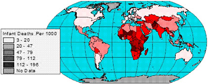
FIGURE 11.1 Map of infant mortality rates.
be essential to later activities and investigations in the unit. Following my own introduction to GIS, however, I decided to try a new approach and introduce sub-Saharan Africa in an altogether different way.
Our unit on sub-Saharan Africa began with the examination of a world map of infant mortality rates (IMR). Figure 11.1 clearly indicated that sub-Saharan Africa has some of the highest IMR rates in the world.
As we looked at the map, class discussion focused on the regional patterns of infant mortality rates that we observed. When I asked students to identify questions that were raised by those patterns, many asked why infant mortality rates in Africa were so high. The question became the springboard for a challenging activity—an investigation of the causes of and potential cures for the high rates of infant mortality in this region.
Before we began our investigation, I asked students to speculate about what might cause a region—any region—to have a high infant mortality rate. We listed possibilities on the board: not enough doctors, not enough hospitals, lack of food, disease, poverty, war. The preliminary list became the basis of our investigation.
I presented students with a scenario to shape their investigation. In the scenario, the students had been asked to serve on a World Health Organization (WHO) task force charged with recommending programs to address the high rates of infant mortality in sub-Saharan Africa (Figure 11.2). The WHO had several program options but, because of cost, they could not implement all of them. The WHO wanted the IMR Task Force to identify the programs that would be most likely to result in reductions in the high infant mortality rates. Among WHO’s program options were providing immunization against preventable childhood diseases, creating public service messages on radio and television regarding key health issues, funding the construction of sanitation systems for water and sewage, training more doctors and nurses, and expanding opportunities for elementary and secondary education. The students’ task was to discover the leading causes of infant mortality in sub-Saharan Africa and identify the programs that would most effectively target those causes.
The class was enthusiastic about the assignment and anxious to get underway. Our investigation began in the computer lab; GIS was to be the IMR Task Force’s principal investigative tool. In a GIS project that I created for them, students began their search for a cause by looking for other indicators that correlated closely with patterns of infant mortality rates (Figure 11.2b). Using GIS, they compared spatial patterns of infant mortality rates with spatial patterns of the following variables: percent of the population with access to safe water, average number of calories consumed
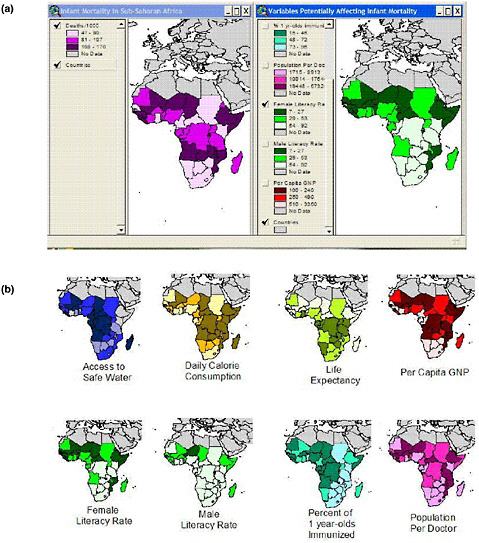
FIGURE 11.2 Maps of variables affecting infant mortality.
per day, percent of one-year-olds immunized against common childhood diseases, population per doctor, life expectancy, female literacy rate, male literacy rate, and per capita gross national product (GNP).
In this initial phase of investigation each student worked independently at his or her own computer although they were free to question one another or share observations while they worked. As they moved between on-screen maps in the project they made notes and listed observations about specific countries and regions, and about the relationships and patterns they detected. Each student was becoming an “expert” in preparation for their upcoming work as a Task Force member.
For the next phase of the investigation, I grouped the students into teams of four or five members. Each team would assume the responsibilities of the Task Force. They had to reach within-group consensus on the most important causal factors in sub-Saharan Africa’s infant mortality rates and on program recommendations to the WHO to address those causal factors. The students had reading materials describing those programs and the costs associated with each. We worked in the classroom at this point, but each group had access to a computer with the GIS project to aid in their discussions and in the preparation of their final report. Each group was to prepare maps and an oral presentation to the WHO, supporting and explaining their decision.
The IMR Task Force groups got to work eagerly. They began to compare notes about the inferences they had drawn from their GIS investigation. It was obvious they were enthusiastic about the activity, but I was totally unprepared for the impassioned debates that ensued! As the teams began their discussions, the classroom erupted with the sounds of spirited argument and deliberation. “Television ads make no sense at all—just look at the per capita GNP. The countries with the highest infant mortality rates have the lowest GNP. These people don’t have televisions—they’re poor.” “It’s got to be education—look at the female literacy rate map. It’s practically a mirror image of infant mortality. Besides, education will help people get better jobs.” “Look how much it costs to train doctors—let’s send in nurses to give vaccinations. The countries that aren’t vaccinating babies have high rates of infant mortality. That program is inexpensive, and it will reduce infant mortality now, not ten years from now.”
The GIS-based classroom presentations by each Task Force group provided clear evidence that the project had fostered appreciation for and new understanding about the complex and interrelated factors that contribute to high rates of infant mortality in sub-Saharan Africa. Not only did students appreciate the complexity of causal variables, but they also recognized the myriad obstacles and problems associated with eliminating those causes. The groups’ conclusions and recommendations were not identical, but all were supported by maps and data from their GIS-based investigation. Some groups were convinced that health care initiatives—immunization programs and training doctors—offered the greatest possibility of reducing infant mortality rates. Others felt it was essential to address at once the most basic human needs for food and safe water, while still others focused on education as the only way to bring about lasting and sustained change. Their arguments were eloquent, informed, and credible.
There were several unexpected benefits from this activity. Although I had decided to forgo my traditional map labeling activities, I found that the students had acquired place name recognition as a side effect of working with the project. They noted countries that were high or low in each variable and, in the process, began to learn their names. They’d ask questions like “What’s going on in Mali (or Sierra Leone or Niger)—it’s on practically every map?” Such questions set the stage for later investigations into subjects like desertification in Africa’s Sahel or the legacy of colonialism in sub-Saharan Africa. Essentially, I discovered that the project not only accomplished its primary objective of teaching about infant mortality in sub-Saharan Africa, but it also provided a foundation for investigations and lessons yet to come.
The success of this project reinforced all my beliefs about the value of GIS in the classroom. GIS enabled me to be the facilitator of a learning process, not the disseminator of information. My students loved the sense of discovery they experienced with GIS and felt empowered by the opportunity to investigate and draw their own conclusions. Students experienced active learning through their own hands-on exploration and analysis of data rather than passively absorbing and restating information from secondary sources or information authority figures. Their powerful learning experience resulted from an inquiry process, not from being provided with “the right answer,” and GIS was the engine that powered the inquiry process. (Lyn Malone, personal communication, 2003).
11.3 MEETING THE CHALLENGE TO LEARN TO THINK SPATIALLY
As this example shows, GIS is a powerful support system that can, with well-trained and imaginative teachers and the appropriate school infrastructure, help to reshape learning across the curriculum.
These students did show a developing spatial literacy. They broadened and deepened their spatial knowledge (through, for example, the search for explanatory factors that would account for patterns of infant mortality). They showed an increasing command over spatial ways of thinking and acting (through the comparison of spatial patterns of infant mortality with the spatial patterns of the possible explanatory factors). They developed spatial capabilities (through the use of GIS). They also became more critical spatial thinkers. They had to find and then use spatial data. They had to construct, articulate, and defend a line of reasoning (“Television ads make no sense at all—just look at the per capita GNP. The countries with the highest infant mortality rates have the lowest GNP. These people don’t have televisions—they’re poor”).
As Lyn Malone rightly concludes, the power of this learning experience is the result of an inquiry process that is supported by a tool (in this case GIS). However, GIS is only one of a suite of support systems, high and low tech in nature, that must be brought to bear in fostering an understanding for and appreciation of spatial thinking. All students deserve and need the opportunity to be challenged, to be supported, and to become critical spatial thinkers.
The premise for this report is the need for systemic change. Fundamental to that change is a national commitment to the goal of spatial literacy. Spatial thinking must be recognized as a fundamental and necessary part of the process of K–12 education.
The committee does not view spatial thinking as one more piece to be added on to an already overburdened curricular structure. Instead, spatial thinking is seen as an integrator and a facilitator for problem solving across the curriculum. Spatial thinking is not an add-on but a missing link across the curriculum. Thus, integration and infusion of spatial thinking can help to achieve existing curricular objectives. The idea of spatial thinking does not and should not stand alone, but equally well, without explicit attention to it, we cannot meet our responsibility for equipping the next generation of students for life and work in the twenty-first century.


